
جميع الكتب

مهني

1 Markets I: The Ecosystem and Exchange-Traded Marketsالأسواق عبر الإنترنت 2 Markets II: Rates, FX and Creditالأسواق عبر الإنترنت 3 Markets III: Commodities, Energy and Cryptoالأسواق عبر الإنترنت 4 Quantitative Methodsالأساليب عبر الإنترنت 5 Derivatives and Volatilityالمشتقات عبر الإنترنت 6 Rates, Credit, XVA and Riskالفائدة والائتمان والمخاطر عبر الإنترنت 7 Research Craft: Predictors, Backtests, Measurement, Portfoliosالبحث عبر الإنترنت 8 Strategies I: Equities and Futuresالاستراتيجيات عبر الإنترنت 9 Strategies II: Volatility, Relative Value, Macro and the Bank Desksالاستراتيجيات عبر الإنترنت 10 Microstructure and Executionالتنفيذ عبر الإنترنت 11 Market Making and High-Frequency Tradingصناعة السوق عبر الإنترنت 12 Machine Learning for Marketsتعلم الآلة عبر الإنترنت 13 Low-Latency Softwareالتكنولوجيا عبر الإنترنت 14 Networks, Hardware and Trading Infrastructureالتكنولوجيا عبر الإنترنت 15 Research, Data and Risk Platformsالتكنولوجيا عبر الإنترنت 16 The Desk and the Firmالشركة عبر الإنترنت 17 The Industry: Firms, Roles and Careersالمسارات المهنية عبر الإنترنت 18 The Interview Bookالمسارات المهنية عبر الإنترنت
التطبيقات حول المدرب تسجيل الدخول ابدأ القراءة

Quantitative Finance · المسرد

ما معنى Geodesic distance؟

Definition 10.1 Networks, Hardware and Trading Infrastructure · الفصل 10 — The North American Map

The geodesic distance between two points on the Earth is the length of the shortest path between them along the surface of a reference ellipsoid (for maps and satellite positioning, WGS-84), computed from their latitudes and longitudes.
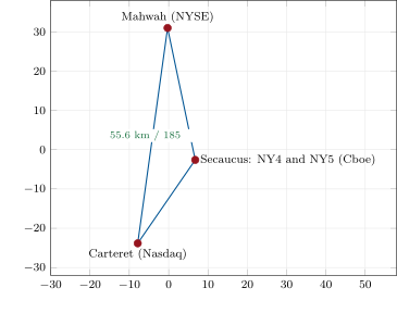
The New Jersey triangle from computed coordinates: each site from its sourced street address and a cited geocoder (), each side labelled with its WGS-84 geodesic distance and light-time in vacuum. The projection is a local equirectangular one centred on 40.8° N, 74.15° W. Data: fig_map.py on firm.geomap.
Figure 10.1. The New Jersey triangle from computed coordinates: each site from its sourced street address and a cited geocoder (Box 10.1), each side labelled with its WGS-84 geodesic distance and light-time in vacuum. The projection is a local equirectangular one centred on 40.8° N, 74.15° W. Data: fig_map.py on firm.geomap.
FromToGeodesicVacuumAirFibre
(km)(µs\text{µ}\mathrm{s})(µs\text{µ}\mathrm{s})(µs\text{µ}\mathrm{s})
MahwahCarteret55.6185.4185.4271.0
MahwahSecaucus NY434.5114.9115.0168.0
Secaucus NY4Carteret25.986.386.3126.2
AuroraCarteret1 180.93 939.03 940.15 758.8
AuroraMahwah1 179.03 932.63 933.85 749.4
AuroraSecaucus NY51 191.13 973.13 974.35 808.7
Aurora350 Cermak52.3174.5174.5255.1
350 CermakCarteret1 129.23 766.73 767.85 506.9
MarkhamMahwah523.71 747.01 747.62 554.2
MarkhamSecaucus NY4550.21 835.31 835.92 683.3
MarkhamCarteret553.11 844.91 845.42 697.2
Table 10.1. Distances and one-way latency floors between the sites of Box 10.1: WGS-84 geodesics (Vincenty’s inverse method) and the time light needs along them in vacuum, in air (n=1.0003n = 1.0003) and in standard single-mode fibre (ng=1.4620n_g = 1.4620). Data: nw_map.pair_rows().
اقرأ في الفصل →