 Coach
CoachThe geodesic distance between two points on the Earth is the length of the shortest path between them along the surface of a reference ellipsoid (for maps and satellite positioning, WGS-84), computed from their latitudes and longitudes.
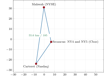
fig_map.py on firm.geomap.| From | To | Geodesic | Vacuum | Air | Fibre |
| (km) | () | () | () | ||
| Mahwah | Carteret | 55.6 | 185.4 | 185.4 | 271.0 |
| Mahwah | Secaucus NY4 | 34.5 | 114.9 | 115.0 | 168.0 |
| Secaucus NY4 | Carteret | 25.9 | 86.3 | 86.3 | 126.2 |
| Aurora | Carteret | 1 180.9 | 3 939.0 | 3 940.1 | 5 758.8 |
| Aurora | Mahwah | 1 179.0 | 3 932.6 | 3 933.8 | 5 749.4 |
| Aurora | Secaucus NY5 | 1 191.1 | 3 973.1 | 3 974.3 | 5 808.7 |
| Aurora | 350 Cermak | 52.3 | 174.5 | 174.5 | 255.1 |
| 350 Cermak | Carteret | 1 129.2 | 3 766.7 | 3 767.8 | 5 506.9 |
| Markham | Mahwah | 523.7 | 1 747.0 | 1 747.6 | 2 554.2 |
| Markham | Secaucus NY4 | 550.2 | 1 835.3 | 1 835.9 | 2 683.3 |
| Markham | Carteret | 553.1 | 1 844.9 | 1 845.4 | 2 697.2 |
nw_map.pair_rows().