
全部书籍

专业

应用 关于 Coach 登录 开始阅读

书籍暂未推出简体中文版——当前显示英文版。

Earth and Space Sciences · 术语表

什么是 Buffer; overlay?

又称: buffer (GIS) · overlay (GIS)

Definition 25.20 University Earth and Space Sciences — Year 3 · 第 25 章 — Remote Sensing and GIS

The buffer of a feature at the distance dd is the region of the map within dd of it. An overlay combines two or more layers of the same area into one, each place of the result carrying the attributes of all of them; the selection of the places that meet several conditions at once is the commonest use.
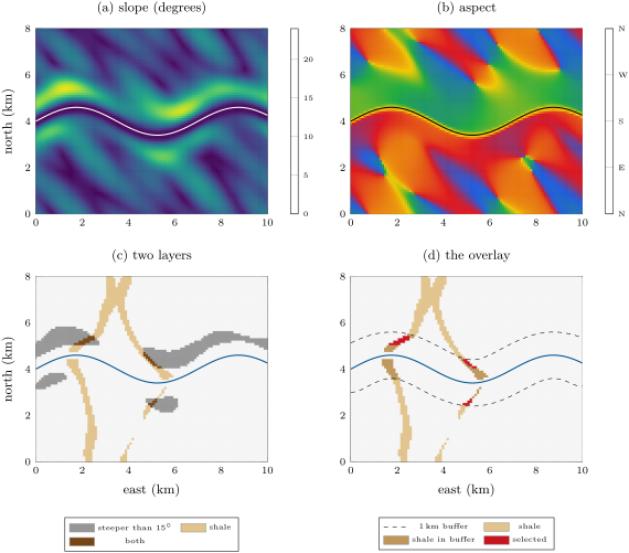
A GIS session on the Varden Hills, from their elevation model on a 100\, m grid. (a) The slope, up to 23 on the valley sides; (b) the aspect, the direction the ground faces, the two sides of the river facing each other; (c) two layers, the cells steeper than 15 and the outcrop of the Jurassic shale; (d) their overlay with the 1\, km buffer of the river (dashed): the 0.32\, km2 of steep shale above the river, a first screen for ground that may slide.
A GIS session on the Varden Hills, from their elevation model on a 100 m100\,\mathrm{m} grid. (a) The slope, up to 23∘23{}^{\circ} on the valley sides; (b) the aspect, the direction the ground faces, the two sides of the river facing each other; (c) two layers, the cells steeper than 15∘15{}^{\circ} and the outcrop of the Jurassic shale; (d) their overlay with the 1 km1\,\mathrm{km} buffer of the river (dashed): the 0.32 km20.32\,\mathrm{km}^{2} of steep shale above the river, a first screen for ground that may slide.
在原文中阅读 →