全部书籍

专业

应用 关于 Coach 登录 开始阅读

书籍暂未推出简体中文版——当前显示英文版。

Earth and Space Sciences · 术语表

什么是 Physical map?

Definition 9.3 Primary & Middle School Earth and Space Sciences · 第 9 章 — The Physical Map of the World

A physical map shows the relief of the land and the depth of the sea with colours, one colour for each step of altitude or depth, and the great rivers, lakes, deserts and ice.
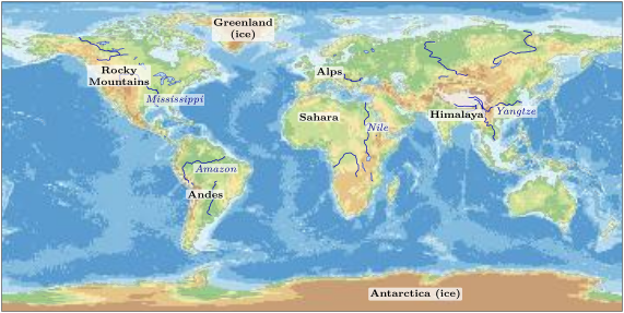

The physical map of the world, with its legend. Each colour is one step of altitude (on land) or of depth (under the sea). Rivers in dark blue. The relief is drawn from one value every degree of latitude and longitude (about every 100 kilometres), so it is smoothed: single summits and narrow trenches do not show. Data: NOAA ETOPO1 relief; rivers, lakes and coastlines from Natural Earth. The physical map of the world, with its legend. Each colour is one step of altitude (on land) or of depth (under the sea). Rivers in dark blue. The relief is drawn from one value every degree of latitude and longitude (about every 100 kilometres), so it is smoothed: single summits and narrow trenches do not show. Data: NOAA ETOPO1 relief; rivers, lakes and coastlines from Natural Earth.
The physical map of the world, with its legend. Each colour is one step of altitude (on land) or of depth (under the sea). Rivers in dark blue. The relief is drawn from one value every degree of latitude and longitude (about every 100 kilometres), so it is smoothed: single summits and narrow trenches do not show. Data: NOAA ETOPO1 relief; rivers, lakes and coastlines from Natural Earth.
在原文中阅读 →
