书籍暂未推出简体中文版——当前显示英文版。
Primary & Middle School Earth and Space Sciences · 1–9 年级
9The Physical Map of the World
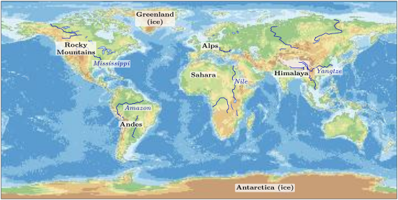
Sami and Noor unfold a big map of the world on the classroom floor and kneel around it. It is not like the maps they know. There are no countries, no borders and no towns. Instead, the land is painted in colours: green along the coasts and in the great flat lands, then pale yellow, then brown, and in a few places almost white. The sea, too, has several blues: pale near the coasts, darker and darker far out in the oceans.
“Why is that part of Asia white?” asks Noor. “Is it snow?” Not quite. On this map, every colour tells how high the land is, or how deep the sea.
You already know
A map shows a place from above, made smaller; its legend explains its colours and symbols (Chapter 4). The land is gathered in seven continents, between five oceans, and a world map is a flattened globe (Chapter 6). Mountains, hills, valleys and plains are the landforms; rivers flow from high land down to the sea (Chapter 2).
9.1 Reading a physical map
To say how high a place is, we need a starting level, the same everywhere on Earth. We take the level of the sea.
Definition 9.1 (Altitude and sea level)
Sea level is the average level of the surface of the sea, between high and low tide. The altitude of a place is its height above sea level, in metres. Under the sea, we speak of depth: how far the sea floor lies below sea level.
A town by the sea has an altitude of a few metres. A village in the mountains may stand at 1 500 metres: one and a half kilometres above the level of the sea, even if it is hundreds of kilometres from any coast.
Definition 9.2 (Relief)
The relief of a region is the shape of its land: where it is high and where it is low, its mountains, plateaus, valleys and plains.
Definition 9.3 (Physical map)
A physical map shows the relief of the land and the depth of the sea with colours, one colour for each step of altitude or depth, and the great rivers, lakes, deserts and ice.

Method 9.4 (Reading a colour on a physical map)
To find the altitude of a place on a physical map:
- find the place, and look at its colour;
- find the same colour in the legend;
- read the step under it: the altitude of the place lies between the two numbers.
The same works at sea, for the depth.
Example 9.5 (Three places)
The mouth of the Amazon, on the coast of South America, is dark green: its altitude is between 0 and 200 metres. The middle of the Sahara is pale green or pale yellow: between 200 and 1 000 metres. The plateau north of the Himalaya, in Asia, is almost white: above 4 000 metres.
9.2 The great mountain ranges
On the map, the brown and white colours are not spread evenly. They form long, narrow bands.
Definition 9.6 (Mountain range)
A mountain range is a long line of mountains, joined together, that stretches over hundreds or thousands of kilometres.
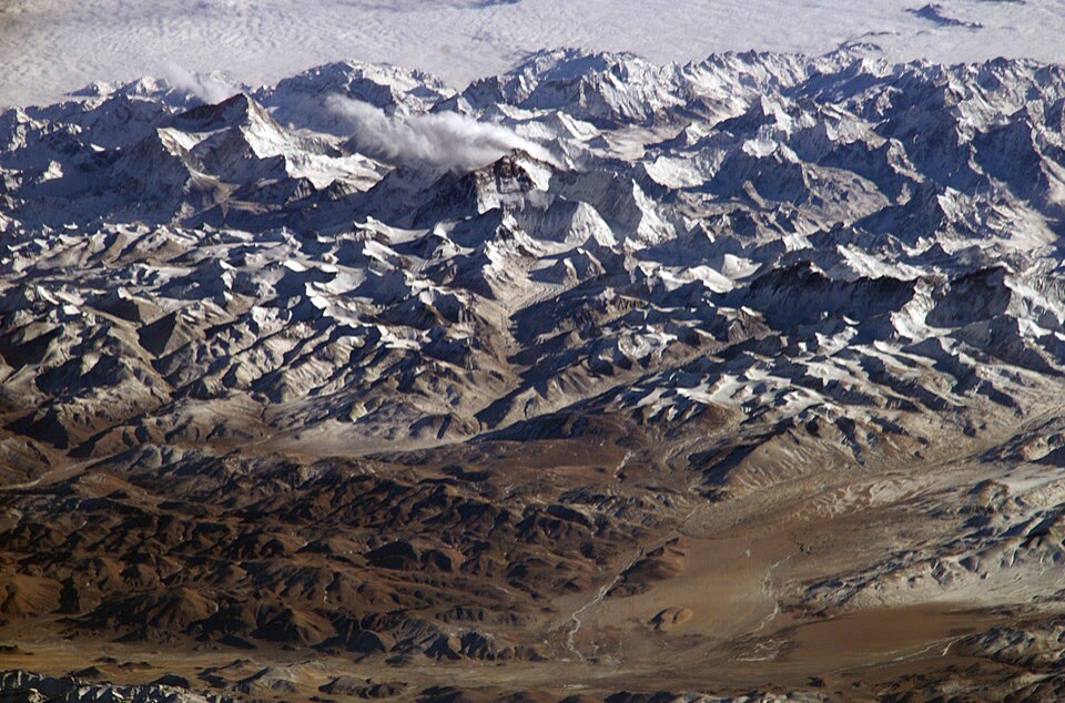
The Andes run along the whole west side of South America. North America has the Rocky Mountains, Europe the Alps, and Asia the highest of all: the Himalaya. There stands the highest mountain on Earth: Mount Everest, 8 849 metres high, measured again in 2020.
9.3 The great rivers and lakes
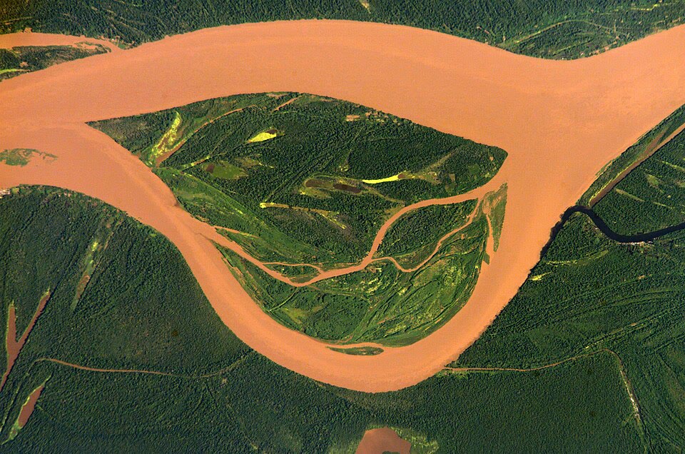
Rain and melted snow run off the land, join into streams and then into rivers, and the rivers carry the water down to the sea. The largest rivers drain whole regions of a continent.
The two longest rivers on Earth are the Nile, in Africa, and the Amazon, in South America. Each is close to 7 000 kilometres long. Which one is the longest? Nobody agrees for sure, because it depends on where you decide that a river starts: among all the little streams that join to make it, which one counts as its true beginning? In 2007, a team that followed the Amazon to a farther source said it was about 6 800 kilometres long, a little longer than the Nile; many reference books still call the Nile the longest.
The Amazon is, without any doubt, the largest river: it carries more water than any other.
Lakes also break records. The largest lake on Earth is the Caspian Sea, between Europe and Asia: it is so big that it is called a sea, but it is closed in by land on every side. It covers more than 370 000 square kilometres. The deepest lake is Lake Baikal, in Russia: in places its bottom lies nearly 2 kilometres below its surface.
9.4 Deserts and the great ice
Two kinds of places stand out on the physical map because almost nothing grows there: the great deserts, where it almost never rains, and the great ice.
The Sahara, in the north of Africa, is the largest hot desert on Earth. It covers about eight and a half million square kilometres. Africa as a whole covers about 30 million square kilometres, so the Sahara is a little more than a quarter of the continent: more than , but less than .
The great ice covers Antarctica, around the South Pole, and most of Greenland, in the far north of the Atlantic. There, the snow of thousands of years has piled up and turned into a thick layer of ice. On the physical map, their colours are those of high land, because the top of the ice is high above sea level.
9.5 The highest and the deepest
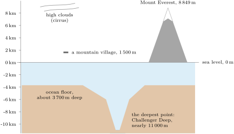
The physical map shows the shape of the Earth’s surface, but it is so small that it hides the extremes. Let us put them side by side, to scale.
Example 9.7 (Everest in the deep)
If we could lift Mount Everest and set it down at the bottom of the Challenger Deep, its summit would still be under the water: about 11 000 metres of trench, against 8 849 metres of mountain. More than 2 kilometres of sea would still cover it.
9.6 Exercises
Exercise 9.1 ★
What is the altitude of a place? From which level is it measured?
Exercise 9.2 ★
Using the legend of the physical map, give the altitude of a place coloured: (a) dark green; (b) pale yellow; (c) almost white.
Solution
Solution of Exercise 9.2.
(a) Dark green: between 0 and 200 metres. (b) Pale yellow: between 500 and 1 000 metres. (c) Almost white: above 4 000 metres.
Exercise 9.3 ★
On which continent is: (a) the Andes; (b) the Himalaya; (c) the Sahara; (d) the Rocky Mountains?
Solution
Solution of Exercise 9.3.
(a) South America. (b) Asia. (c) Africa. (d) North America.
Exercise 9.4 ★
Name the highest mountain on Earth, the largest lake and the deepest lake.
Exercise 9.5 ★
On the physical map, the sea near the coasts is pale blue and the middle of the oceans dark blue. What does that tell you about the depth of the sea?
Exercise 9.6 ★
Why are Antarctica and Greenland coloured like high land on the physical map?
Solution
Solution of Exercise 9.6.
The physical map shows the altitude of the surface. In Antarctica and Greenland the surface is the top of a thick layer of ice, which lies high above sea level, so they get the colours of high land.
Exercise 9.7 ★★
Put in order, from the lowest to the highest: a beach; a village at 1 500 metres; the top of Mount Everest; the bottom of the Challenger Deep; the average floor of the ocean.
Exercise 9.8 ★★
Why can’t we say for sure whether the Nile or the Amazon is the longest river?
Solution
Solution of Exercise 9.8.
A river is made of many streams that join together, and people do not agree on which stream is its true beginning. Measured from a farther source, a river is longer. The Nile and the Amazon are so close in length (each about 6 700 to 6 800 kilometres) that the answer depends on that choice.
Exercise 9.9 ★★
Africa covers about 30 million square kilometres. Which part of it is a quarter? A third? The Sahara covers about eight and a half million square kilometres: is it more or less than a quarter of Africa? More or less than a third?
Solution
Solution of Exercise 9.9.
A quarter of 30 million is seven and a half million square kilometres (30 divided by 4); a third is 10 million (30 divided by 3). The Sahara, eight and a half million, is more than a quarter of Africa but less than a third.
Exercise 9.10 ★★
A mountain hut stands at 2 500 metres, and a lake below it at 1 000 metres. How many metres higher is the hut? Which colours do they have on the physical map?
Solution
Solution of Exercise 9.10.
: the hut is 1 500 metres higher. The hut, between 2 000 and 4 000 metres, is brown; the lake, at 1 000 metres, is at the boundary between pale yellow (500 to 1 000) and light brown (1 000 to 2 000): either is accepted.
Exercise 9.11 ★★★
A plane flies 10 kilometres above sea level. Is it higher than Mount Everest? By how many metres? If it flew over the Challenger Deep, how far above the bottom of the trench would it be (take 11 000 metres for the trench)?