
全部书籍

专业

应用 关于 Coach 登录 开始阅读

书籍暂未推出简体中文版——当前显示英文版。

Earth and Space Sciences · 术语表

什么是 Raster and vector data?

又称: raster data · vector data (GIS)

Definition 25.16 University Earth and Space Sciences — Year 3 · 第 25 章 — Remote Sensing and GIS

Raster data represent a layer by a grid of cells, each holding one value: a reflectance, an elevation, a class. Vector data represent it by points, lines and polygons given by the coordinates of their vertices, each carrying a row of attributes in a table.
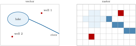
The same map as vector data (left: a polygon, a line and two points, exact in position, each with its attributes) and as raster data (right: one value per cell, the lake by the cells whose centre lies in it, the river and the wells by the cells they cross). A raster is easy to compute with, cell by cell; a vector layer keeps shapes and topology at any scale.
在原文中阅读 →