
All books

Professional

Apps About Coach Log in Start reading

Earth and Space Sciences · Glossary

What is River-, wave- and tide-dominated deltas?

Also known as: river-dominated delta · wave-dominated delta · tide-dominated delta

Definition 21.13 University Earth and Space Sciences — Year 1 · Chapter 21 — Clastic Sediments and Their Environments

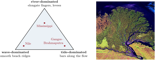
A delta is river-dominated when the river’s supply overwhelms the waves and tides, and its distributary channels, confined by their own levees, build long fingers of sand into the sea; it is wave-dominated when waves rework the sand brought to the mouths into beaches and beach ridges along a smooth, arched coast; it is tide-dominated when tidal currents, flowing in and out of the mouths, shape its sand into bars and ridges parallel to the flow, separated by funnel-shaped channels.
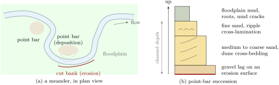
(a) A meandering river (schematic): the current erodes the outer bank of each bend and lays sand on the point bar inside it; the curved scroll lines are the bar’s successive positions. (b) The succession left by a migrating point bar, the width of each layer proportional to its grain size (schematic). It fines upward, and its thickness records the depth of the channel.
Left: the three end members of deltas, after the process that shapes them (schematic; the positions of the three examples are indicative). Right: the delta of the Lena, in Siberia, built into the Laptev Sea (top); the river enters from the bottom right and splits into hundreds of distributaries. Landsat 7 false-colour image of 27 February 2000, U.S. Geological Survey, public domain, via Wikimedia Commons.
Read in context →