全部书籍

专业

应用 关于 Coach 登录 开始阅读

书籍暂未推出简体中文版——当前显示英文版。

Earth and Space Sciences · 术语表

什么是 Steady-state river profile?

Definition 18.8 University Earth and Space Sciences — Year 3 · 第 18 章 — Quantitative Geomorphology

A river profile is in steady state when its elevation no longer changes in time: at every point incision balances rock uplift relative to the outlet.
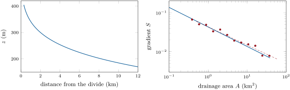

The steady-state profile of the invented upland river west of the Varden Hills (U = 0.043\, mm/ yr, K = 10-6\, yr-1, m = 0.5, n = 1), from its channel head to the outlet at 170\, m. Right, gradient against area: the model (blue line) and twelve gradients measured over reaches of 200\, m with a scatter of about 10\,\% (red dots), whose least-squares line (dashed) has a slope of -0.47.
The steady-state profile of the invented upland river west of the Varden Hills (U=0.043 mm/yrU = 0.043\,\mathrm{mm}/\mathrm{yr}, K=10−6 yr−1K = 10^{-6}\,\mathrm{yr}^{-1}, m=0.5m = 0.5, n=1n = 1), from its channel head to the outlet at 170 m170\,\mathrm{m}. Right, gradient against area: the model (blue line) and twelve gradients measured over reaches of 200 m200\,\mathrm{m} with a scatter of about 10 %10\,\% (red dots), whose least-squares line (dashed) has a slope of −0.47-0.47.
在原文中阅读 →