
সব বই

পেশাদার

1 Markets I: The Ecosystem and Exchange-Traded Marketsবাজার অনলাইন 2 Markets II: Rates, FX and Creditবাজার অনলাইন 3 Markets III: Commodities, Energy and Cryptoবাজার অনলাইন 4 Quantitative Methodsপদ্ধতি অনলাইন 5 Derivatives and Volatilityডেরিভেটিভস অনলাইন 6 Rates, Credit, XVA and Riskসুদহার, ঋণ ও ঝুঁকি অনলাইন 7 Research Craft: Predictors, Backtests, Measurement, Portfoliosগবেষণা অনলাইন 8 Strategies I: Equities and Futuresকৌশল অনলাইন 9 Strategies II: Volatility, Relative Value, Macro and the Bank Desksকৌশল অনলাইন 10 Microstructure and Executionএক্সিকিউশন অনলাইন 11 Market Making and High-Frequency Tradingমার্কেট মেকিং অনলাইন 12 Machine Learning for Marketsমেশিন লার্নিং অনলাইন 13 Low-Latency Softwareপ্রযুক্তি অনলাইন 14 Networks, Hardware and Trading Infrastructureপ্রযুক্তি অনলাইন 15 Research, Data and Risk Platformsপ্রযুক্তি অনলাইন 16 The Desk and the Firmপ্রতিষ্ঠান অনলাইন 17 The Industry: Firms, Roles and Careersক্যারিয়ার অনলাইন 18 Interviews I: Maths, Probability and Speedক্যারিয়ার অনলাইন 19 Interviews II: Markets, Trading Games and the Final Roundক্যারিয়ার অনলাইন 20 Interviews III: Codeক্যারিয়ার অনলাইন
অ্যাপ পরিচিতি Coach সাইন ইন পড়া শুরু করো

বইগুলো এখনো বাংলা ভাষায় পাওয়া যায় না — ইংরেজি সংস্করণ দেখানো হচ্ছে।

Earth and Space Sciences · পরিভাষা

Depression and anticyclone কী?

অন্য নাম: depression (weather) · anticyclone

Definition 25.3 Primary & Middle School Earth and Space Sciences · অধ্যায় 25 — Air Masses, Fronts and Weather Maps

A depression, or low, is a region where the pressure at sea level is lower than all around it. An anticyclone, or high, is a region where it is higher than all around it.
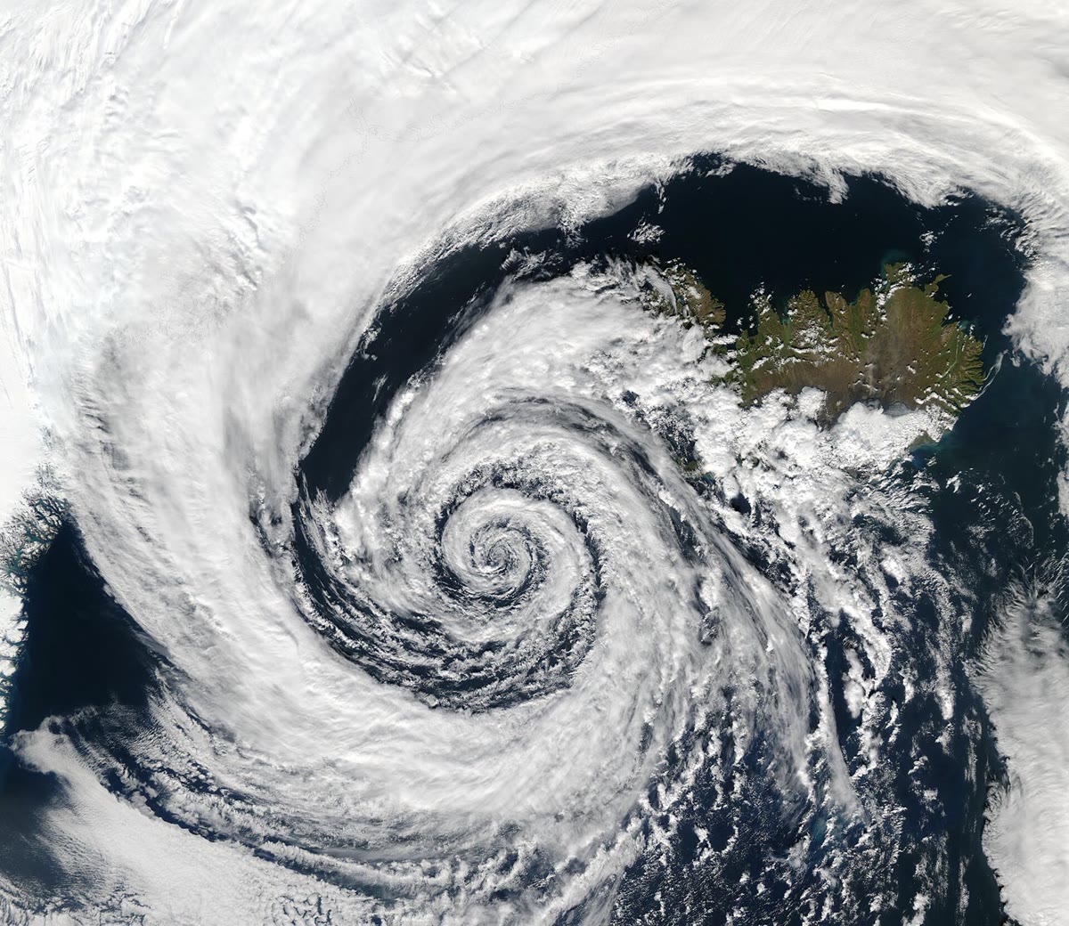
A depression south-west of Iceland (the island at the top right) seen by NASA’s Aqua satellite on 4 September 2003. Its clouds spiral in towards the centre, turning anticlockwise as in every depression of the northern hemisphere. NASA/GSFC, MODIS Rapid Response Team, Jacques Descloitres (public domain, via Wikimedia Commons).

উদাহরণ

Example 25.7 (Reading a barometer’s record)

For the first 8 hours the pressure rises to about 1031 hPa1031\,\mathrm{hPa}: the anticyclone passes over S, with settled weather. Then it falls for 30 hours, by about 45 hPa45\,\mathrm{hPa}: the depression is coming. It falls fastest a few hours before the warm front passes, more slowly in the warm air behind it, and reaches its lowest, about 986 hPa986\,\mathrm{hPa}, just as the cold front passes. Then it rises: the depression is moving away, and the cooler, clearer air behind the cold front arrives.

প্রসঙ্গসহ পড়ো →