All books

Professional

Apps About Coach Log in Start reading

Earth and Space Sciences · Glossary

What is Isobar?

Definition 25.4 Primary & Middle School Earth and Space Sciences · Chapter 25 — Air Masses, Fronts and Weather Maps

An isobar is a line on a map joining places where the pressure at sea level is the same. Isobars are labelled in hectopascals and are often drawn every 4 hPa4\,\mathrm{hPa}.

A weather map of an imaginary day in the northern hemisphere, computed from a model of the pressure. Isobars every 4\, hPa; the depression L (980\, hPa) carries a warm front (red) and a cold front (blue); the anticyclone H (1034\, hPa) lies to the east. Green arrows: the wind, longer where it is stronger. T: the town of the problem.
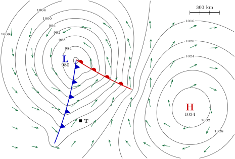
A weather map of an imaginary day in the northern hemisphere, computed from a model of the pressure. Isobars every 4 hPa4\,\mathrm{hPa}; the depression L (980 hPa980\,\mathrm{hPa}) carries a warm front (red) and a cold front (blue); the anticyclone H (1034 hPa1034\,\mathrm{hPa}) lies to the east. Green arrows: the wind, longer where it is stronger. T: the town of the problem.
Read in context →