
全部书籍

专业

应用 关于 Coach 登录 开始阅读

书籍暂未推出简体中文版——当前显示英文版。

Earth and Space Sciences · 术语表

什么是 Map projection?

又称: Mercator projection · equal-area projection

Definition 32.1 Primary & Middle School Earth and Space Sciences · 第 32 章 — Maps of the Whole Earth

A map projection is a rule that sends every point of the globe, given by its latitude and longitude, to a point of a flat map. On a Mercator projection, the parallels and the meridians are straight lines crossing at right angles, and the shape of every small region is kept, but areas are enlarged more and more towards the poles. On an equal-area projection, every region keeps its true area compared with the others, but shapes are bent, more and more towards the edges of the map.
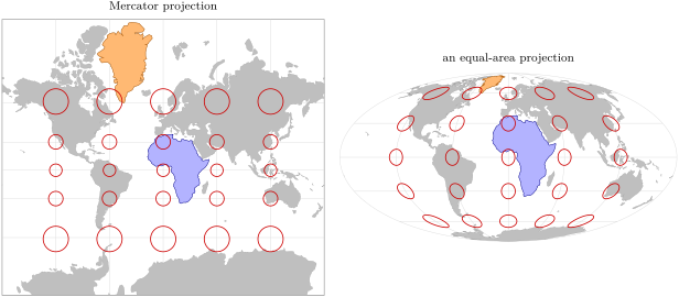
The same world on two projections. Red: circles of the same size on the globe, centred every 30 of latitude and 60 of longitude. Orange: Greenland; blue: the African mainland. On the Mercator map (left, cut at 80 S and 84 N, since the poles would be infinitely far), the two look about the same size; on the equal-area map (right), Africa is about 14 times larger, as on the globe. Coastlines from Natural Earth.
The same world on two projections. Red: circles of the same size on the globe, centred every 30∘30{}^{\circ} of latitude and 60∘60{}^{\circ} of longitude. Orange: Greenland; blue: the African mainland. On the Mercator map (left, cut at 80∘80{}^{\circ} S and 84∘84{}^{\circ} N, since the poles would be infinitely far), the two look about the same size; on the equal-area map (right), Africa is about 14 times larger, as on the globe. Coastlines from Natural Earth.
在原文中阅读 →