
সব বই

পেশাদার

1 Markets I: The Ecosystem and Exchange-Traded Marketsবাজার অনলাইন 2 Markets II: Rates, FX and Creditবাজার অনলাইন 3 Markets III: Commodities, Energy and Cryptoবাজার অনলাইন 4 Quantitative Methodsপদ্ধতি অনলাইন 5 Derivatives and Volatilityডেরিভেটিভস অনলাইন 6 Rates, Credit, XVA and Riskসুদহার, ঋণ ও ঝুঁকি অনলাইন 7 Research Craft: Predictors, Backtests, Measurement, Portfoliosগবেষণা অনলাইন 8 Strategies I: Equities and Futuresকৌশল অনলাইন 9 Strategies II: Volatility, Relative Value, Macro and the Bank Desksকৌশল অনলাইন 10 Microstructure and Executionএক্সিকিউশন অনলাইন 11 Market Making and High-Frequency Tradingমার্কেট মেকিং অনলাইন 12 Machine Learning for Marketsমেশিন লার্নিং অনলাইন 13 Low-Latency Softwareপ্রযুক্তি অনলাইন 14 Networks, Hardware and Trading Infrastructureপ্রযুক্তি অনলাইন 15 Research, Data and Risk Platformsপ্রযুক্তি অনলাইন 16 The Desk and the Firmপ্রতিষ্ঠান অনলাইন 17 The Industry: Firms, Roles and Careersক্যারিয়ার অনলাইন 18 Interviews I: Maths, Probability and Speedক্যারিয়ার অনলাইন 19 Interviews II: Markets, Trading Games and the Final Roundক্যারিয়ার অনলাইন 20 Interviews III: Codeক্যারিয়ার অনলাইন
অ্যাপ পরিচিতি Coach সাইন ইন পড়া শুরু করো

বইগুলো এখনো বাংলা ভাষায় পাওয়া যায় না — ইংরেজি সংস্করণ দেখানো হচ্ছে।

Earth and Space Sciences · পরিভাষা

Volcanic arc কী?

Definition 22.1 High School Earth and Space Sciences · অধ্যায় 22 — Magmatism at Subduction Zones

A volcanic arc is a line of volcanoes on the overriding plate of a subduction zone, parallel to the trench, standing above the place where the slab has reached a depth of about a hundred kilometres. It is an island arc when it rises from the sea floor, as in Japan or Indonesia, and a continental arc when it stands on a continent, as in the Andes or the Cascades.
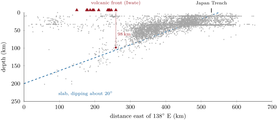
A section across north-east Japan at true scale: the earthquakes of magnitude 4.5 or more between 37.5 and 40.5 N, 1976–2025 (grey), the volcanoes of the same band (red triangles) and the line fitted to the earthquakes deeper than 70\, km (blue, dashed). Two out of five of the shallow events east of 141.5 E date from 2011, the year of the great earthquake of March. Data: USGS earthquake catalogue; Smithsonian Global Volcanism Program; plate boundaries of Bird (2003).
A section across north-east Japan at true scale: the earthquakes of magnitude 4.5 or more between 37.5∘37.5{}^{\circ} and 40.5∘40.5{}^{\circ} N, 1976–2025 (grey), the volcanoes of the same band (red triangles) and the line fitted to the earthquakes deeper than 70 km70\,\mathrm{km} (blue, dashed). Two out of five of the shallow events east of 141.5∘141.5{}^{\circ} E date from 2011, the year of the great earthquake of March. Data: USGS earthquake catalogue; Smithsonian Global Volcanism Program; plate boundaries of Bird (2003).

উদাহরণ

Example 22.4 (North-east Japan)

In the band of the figure, the easternmost volcano is Iwate, at 141.0∘141.0{}^{\circ} E, and the Japan Trench lies at 144.1∘144.1{}^{\circ} E. One degree of longitude there is 111.2cos⁡39∘≈86.4 km111.2\cos39{}^{\circ} \approx 86.4\,\mathrm{km}, so d≈3.12×86.4≈270 kmd \approx 3.12 \times 86.4 \approx 270\,\mathrm{km}. The deep earthquakes dip at about 20∘20{}^{\circ}, and

H=270×tan⁡20∘≈98 km.H = 270 \times \tan20{}^{\circ} \approx 98\,\mathrm{km}.

The earthquakes deeper than 70 km70\,\mathrm{km} that lie beneath the front itself have a median depth of 98 km98\,\mathrm{km}: the two agree, close to the world average.

প্রসঙ্গসহ পড়ো →