书籍暂未推出简体中文版——当前显示英文版。
High School Earth and Space Sciences · 10–12 年级
22Magmatism at Subduction Zones
On 18 May 1980, at 8:32 in the morning, a magnitude 5.1 earthquake shook Mount St. Helens. At once the north flank of the volcano, which had been bulging outwards by about two metres a day, slid away: the largest debris avalanche in recorded history, about of rock. Freed of its load, the gas-rich magma inside blew out sideways through the scar, at no less than , flattening forests over . Within fifteen minutes a column of ash stood more than high, and the eruption went on for nine hours. Sixty-one people were killed or never found.
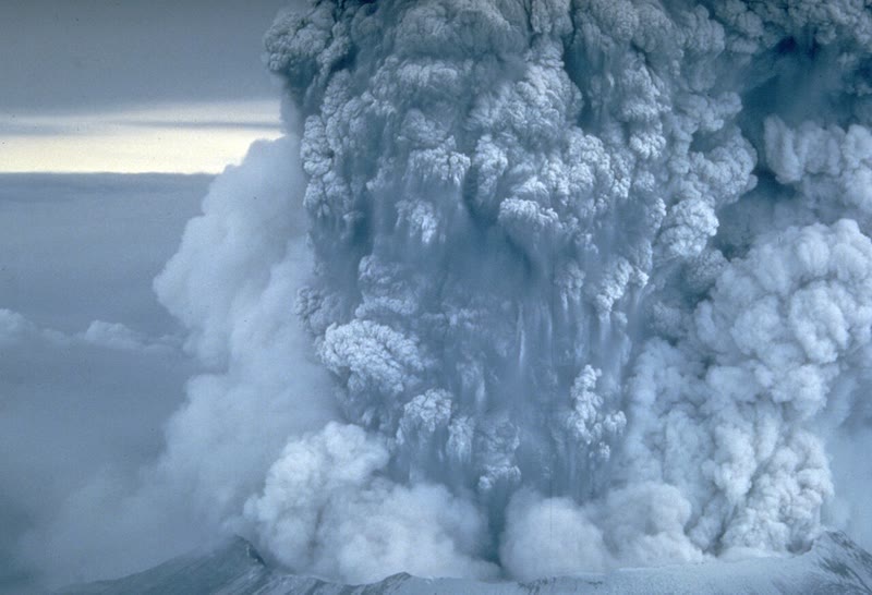
Mount St. Helens is one of a line of volcanoes — Baker, Rainier, Hood, Shasta and others — that stands above the place where a small oceanic plate, the Juan de Fuca Plate, sinks beneath North America. This chapter asks why volcanoes are found there, why their eruptions are so often violent, and what becomes of the magma that never reaches the surface.
You already know
At a subduction zone, a plate of oceanic lithosphere sinks back into the mantle beneath another plate; its earthquakes, the Wadati–Benioff zone, trace the slab down to as deep as (Chapter 15). The mantle is made of peridotite; it is solid, but a rock that rises and is less squeezed may melt in part, by decompression melting, as beneath a ridge (Chapter 14). Andesite is a volcanic rock between basalt and rhyolite, diorite its plutonic equivalent, and a pluton a large body of magma that cooled underground (Chapter 17). The continental crust is thick and light, mostly granitic rock on top (Chapter 19). An explosive eruption blows the magma to pieces with its own gas (Book 1, grade 7).
22.1 Volcanic arcs
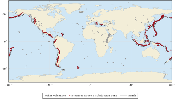
Most of the active volcanoes on land do not stand at random. Of the 1214 volcanoes that have erupted since the end of the last ice age and are listed in the catalogue of the Global Volcanism Program, 838 — more than two out of three — stand above a subduction zone. Around the Pacific they make an almost unbroken ring, often called the Ring of Fire, and every line of them runs parallel to a trench, on the side of the plate that does not sink.
Definition 22.1 (Volcanic arc)
A volcanic arc is a line of volcanoes on the overriding plate of a subduction zone, parallel to the trench, standing above the place where the slab has reached a depth of about a hundred kilometres. It is an island arc when it rises from the sea floor, as in Japan or Indonesia, and a continental arc when it stands on a continent, as in the Andes or the Cascades.
The edge of the arc nearest the trench is called the volcanic front: on the trench side of it, there are no volcanoes at all. How deep is the slab beneath it?
Proposition 22.2 (The slab beneath the volcanic front)
If the slab is a plane that dips at an angle from the trench, and the volcanic front lies at a horizontal distance from the trench, then the top of the slab lies beneath the front at a depth
Proof. Take a vertical section across the trench. The slab, the surface and the vertical line beneath the front make a right triangle, with the right angle beneath the front: the side along the surface is , the vertical side is , and the angle at the trench is . So . ∎
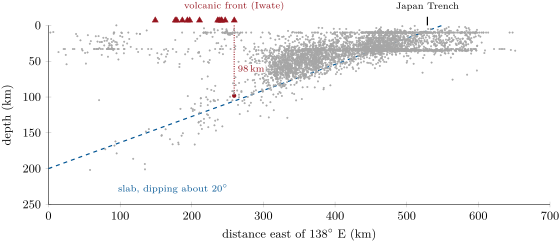
A compilation of 839 volcanic centres along of arcs measured beneath each of them: averaged over stretches of arc long, it ranges from 72 to , with a mean of . Arcs above steep slabs lie close to their trench, arcs above gently dipping slabs far from it, but the slab beneath them is always about a hundred kilometres down.
Method 22.3 (Finding the slab under a volcano)
- Take the earthquakes of a narrow band across the arc, and plot their depth against their distance across it, at true scale.
- Keep the earthquakes deeper than about : shallower ones also occur in the overriding plate and on the fault between the two plates.
- Draw the line, or read the depth, of the deep earthquakes beneath the volcanic front: that is the depth of the slab there.
- Check it with , measuring from the trench and the dip on the section.
Example 22.4 (North-east Japan)
In the band of the figure, the easternmost volcano is Iwate, at E, and the Japan Trench lies at E. One degree of longitude there is , so . The deep earthquakes dip at about , and
The earthquakes deeper than that lie beneath the front itself have a median depth of : the two agree, close to the world average.
22.2 Water melts the mantle
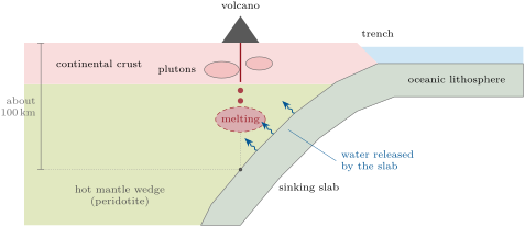
Beneath an arc, the slab is cold, and so is the oceanic crust on top of it: it cannot melt. The magma must come from the hot mantle above the slab, the mantle wedge. But the wedge is not rising, so it cannot melt by decompression as it does beneath a ridge. Something else lowers its melting temperature: water.
The oceanic crust is soaked in sea water near the ridge where it forms, and much of that water ends up locked inside its minerals, above all in serpentine, made from the olivine and pyroxene of the crust. As the slab sinks and warms, these minerals break down and give their water away. The water rises into the hot peridotite of the wedge above.
Definition 22.5 (Hydrous melting)
Hydrous melting (or flux melting) is the partial melting of a rock caused by the addition of water, which lowers the temperature at which the rock begins to melt.
The temperature at which a rock begins to melt, at a given pressure, is its solidus. For dry peridotite it is well known; with water it is much harder to measure, and published values still differ by 200 to . The most recent experiments place it between 950 and at , about down, and just above from 5 to . Dry peridotite at begins to melt only at about : water lowers the solidus by about .
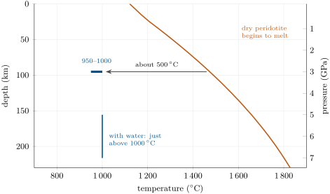
So the water does what heating alone could not: it makes part of the hot wedge melt. The magma, lighter than the solid mantle around it, rises towards the surface; some erupts, much more stays and cools underground. The place where the water is set free, and where the wedge above it is hot enough to melt once wet, is what fixes the volcanic front about a hundred kilometres above the slab.
22.3 Andesites and granodiorites
The first melts of wet peridotite are not basaltic. In experiments at , water-saturated peridotite gives melts of andesitic composition. Rising through the thick crust of the arc, magmas also change as they cool, from basaltic towards andesitic and rhyolitic. Arc magmas are therefore richer in silica than the basalts of ridges — andesitic magma holds 55 to of it — and they carry the water that made them.
Both properties make their eruptions violent. The more silica a magma holds, the more viscous it is, and the harder it is for its gas to escape; explosive eruptions are favoured by a high gas content and a high viscosity, as in andesitic and rhyolitic magmas. Almost all composite volcanoes stand above subduction zones: cones thousands of metres high and up to across, with slopes of 10 to 30 degrees, whose eruptions range from quiet lava flows to explosions. Beneath Mount St. Helens, a magma chamber about wide extends from about 6 to down.
Most arc magma never erupts. It cools slowly in the crust and crystallises into coarse-grained rocks.
Definition 22.6 (Granodiorite)
Granodiorite is a coarse-grained plutonic rock like granite, but with more plagioclase than potassium feldspar: 20 to of its light minerals are quartz, and 65 to of its feldspar is plagioclase; it often holds biotite or hornblende.
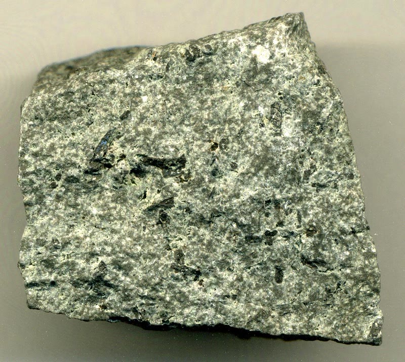
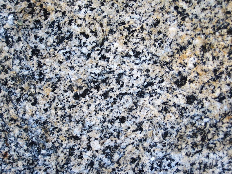
On average, the upper continental crust holds about : it is felsic, like the granites that arcs make in quantity in their batholiths.
Definition 22.7 (Batholith)
A batholith is a large mass of plutonic rock that covers more than where erosion has exposed it. It forms where many plutons, intruded one after another, join beneath the surface.
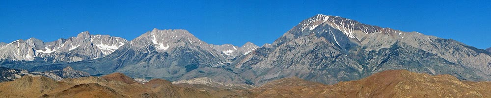
One of the largest in the world, the Coast Plutonic Complex, runs along the Pacific coast from the Vancouver region of western Canada to south-eastern Alaska. The Sierra Nevada batholith of California formed above a subduction zone; most of its granites in Yosemite crystallised in the Cretaceous, 105 to 85 million years ago. The rocks above them were worn away over millions of years, and the plutons that cooled deep down now form the mountains.
22.4 How continents grow
Definition 22.8 (Continental growth)
Continental growth is the addition of new continental crust, made from the mantle, mostly by the magmatism of arcs. The net growth of the continents is that addition minus the continental crust that returns to the mantle.
Arcs are where the light rock of the continents is made. Estimates of the magma that arcs add today are about a year at island arcs and a year at continental arcs; averaged over the long term, about a year. But subduction zones also take continental crust back into the mantle: sediment carried down with the slab and pieces of the overriding plate scraped from beneath, about a year. The two are close, and the net growth of the continents over the last several hundred million years may have been nil, or even negative.
Continents also grow at their edges in another way. Continental crust is too light to be subducted, so when a plate carries a continent into a trench the two continents are welded together in a collision (Chapter 20). Each continent has an old core, a craton, surrounded by belts of younger rock, the deformed roots of former mountain belts, added one after another at its edges (Chapter 19).
22.5 Exercises
Exercise 22.1 ★
Give the word: (a) a line of volcanoes parallel to a trench, on the plate that does not sink; (b) melting caused by adding water to a rock; (c) a plutonic rock with more plagioclase than potassium feldspar and more than quartz; (d) a mass of plutonic rock larger than ; (e) the addition of new continental crust made from the mantle.
Solution
Solution of Exercise 22.1.
(a) a volcanic arc; (b) hydrous melting (flux melting); (c) a granodiorite; (d) a batholith; (e) continental growth.
Exercise 22.2 ★
On 18 May 1980 the ash column of Mount St. Helens rose more than in less than 15 minutes. (1) What was its least mean rising speed, in and in ? (2) Compare it with the speed of the lateral blast, at least .
Solution
Solution of Exercise 22.2.
(1) At least , that is . (2) The blast was at least times faster.
Exercise 22.3 ★
Of the 1214 volcanoes of the catalogue active since the end of the last ice age, 838 stand above a subduction zone. (1) What percentage is that? (2) On which side of a trench are these volcanoes? (3) Why are there none between the trench and the volcanic front?
Solution
Solution of Exercise 22.3.
(1) , about . (2) On the side of the plate that overrides, the one that does not sink. (3) Between the trench and the front the slab is not yet deep enough: it has not reached the depth, about a hundred kilometres, where its water is set free into a mantle hot enough to melt once wet.
Exercise 22.4 ★
A coarse-grained rock holds quartz, plagioclase, potassium feldspar and biotite and hornblende. (1) What fraction of its feldspar is plagioclase? (2) Is it a granodiorite?
Solution
Solution of Exercise 22.4.
(1) : of the feldspar is plagioclase. (2) Yes: it is coarse grained, holds more than quartz, and its plagioclase fraction lies between 65 and .
Exercise 22.5 ★
Give two reasons why the volcanoes of arcs erupt more explosively than those of ridges.
Solution
Solution of Exercise 22.5.
Arc magmas are richer in silica, so they are more viscous; and they carry the water that made them, so they are rich in gas. A high viscosity and a high gas content both favour explosive eruptions.
Exercise 22.6 ★★
(1) A volcanic front lies from its trench, above a slab that dips at . How deep is the slab beneath it? (2) Compare with the average of .
Solution
Solution of Exercise 22.6.
(1) . (2) It is the world average.
Exercise 22.7 ★★
Take the slab to lie beneath every volcanic front. How far from the trench is the front when the slab dips at , and when it dips at ? What does that tell you about where to look for the arc?
Solution
Solution of Exercise 22.7.
: at , and at . The gentler the slab, the farther from the trench the arc stands.
Exercise 22.8 ★★
At , the pressure is about . (1) Using ( in , in ), compute the temperature at which dry peridotite begins to melt there. (2) With water, it begins to melt at about . By how much does water lower it? (3) The mantle wedge there is at, say, . Does it melt dry? Wet?
Solution
Solution of Exercise 22.8.
(1) . (2) By about . (3) Dry, no: is below . Wet, yes: it is above .
Exercise 22.9 ★★
The debris avalanche of Mount St. Helens moved about of rock. Arcs add about of new crust a year. (1) How many days of the world’s arc magmatism does the avalanche represent? (2) Why is the comparison only a matter of size?
Solution
Solution of Exercise 22.9.
(1) of a year, about 340 days. (2) The avalanche moved old rock that already existed; arcs make new rock from the mantle. Only the volumes are compared.
Exercise 22.10 ★★
(1) How much new crust do arcs add in a million years at a year? (2) The continental crust holds about . How long would arcs alone take to make that volume, if none of it were lost? (3) Compare with the age of the Earth, 4.5 billion years.
Solution
Solution of Exercise 22.10.
(1) . (2) years, 3.3 billion years. (3) It is less than the age of the Earth, so arcs could have made the whole continental crust; but subduction also takes crust back, so in fact much of the crust has been made and destroyed more than once.
Exercise 22.11 ★★
(1) In the section across Japan, why are many earthquakes shallower than left out when the slab is fitted? (2) The deep earthquakes lie down at E and at E, with per degree. Compute the dip of the slab.
Solution
Solution of Exercise 22.11.
(1) Shallow earthquakes also occur in the overriding plate and on the fault between the two plates; only the deep ones lie in the slab alone. (2) over : , .
Exercise 22.12 ★★★
Show that, for a front at distance from the trench above a slab of dip , the distance measured down the slab from the trench to the point beneath the front is . For Japan (, ), how long is it? The Pacific Plate moves towards Japan at about a year; taking that speed all along the slab, how long does a piece of sea floor take to travel from the trench to beneath the volcanoes?
Solution
Solution of Exercise 22.12.
In the right triangle of the proposition, the slab is the hypotenuse and the side next to the angle , so and . For Japan, . At a year: years, about 3.5 million years.
Exercise 22.13 ★★★
The magma chamber of Mount St. Helens is about wide and extends from about 6 to down. (1) Treating it as a vertical cylinder, estimate its volume. (2) Compare it with the of the avalanche. (3) Compute the lithostatic pressure at its top and bottom (, ).
Solution
Solution of Exercise 22.13.
(1) . (2) About times the volume of the avalanche. (3) : at , ; at , about = .
Exercise 22.14 ★★★
Arcs add about of crust a year, and subduction zones take back about . (1) What is the net change per million years? (2) Over 500 million years, what fraction of a crust of is that? (3) The authors call the net growth “effectively nil”. Why, given the uncertainty of each estimate?
Solution
Solution of Exercise 22.14.
(1) a year, a loss of per million years. (2) , that is of the crust. (3) Each rate is an estimate, uncertain by much more than the difference of a year between them: within the errors, the two balance.
Exercise 22.15 ★★★
A batholith exposes of granodiorite whose plutons solidified between 5 and down. (1) Estimate the volume of magma it represents, taking it thick. (2) At a year, the rate of all the world’s continental arcs together, how long would they take to make it? What does that tell you about the time over which a batholith is built? (3) How much rock had to be eroded from above it before it could be seen?
Problem 22.1
Weekend problem — Beneath the volcanoes of Japan
The volcanoes of north-east Japan between and N lie between E (Megata, the westernmost) and E (Iwate, the easternmost); the Japan Trench lies at E. The table gives the median depth of the earthquakes deeper than in three strips of longitude, 1976–2025. Take for one degree of latitude.
| longitude ( E) | 140.5 | 141.0 | 141.5 |
|---|---|---|---|
| median depth () | 116 | 98 | 80 |
Part I — The volcanic front.
- Show that one degree of longitude at N is about .
- How far is the volcanic front from the trench?
- How wide is the arc, from Iwate to Megata?
- On which plate do the volcanoes stand, and on which side of the trench?
- Why are there no volcanoes between the trench and Iwate?
Part II — The earthquake section.
- By how many kilometres do the median depths change from to E?
- Over what horizontal distance?
- Compute the dip of the slab.
- Continue the line from E, , up to the surface. Where does it reach it, and how far is that from the trench?
- Suggest why the slab is less steep near the trench than deeper down.
Part III — The slab beneath the volcanoes.
- Compute with the distance of question 2 and a dip of .
- Compare it with the median depth beneath the front.
- Compare both with the world range, 72 to , and mean, .
- How deep is the slab beneath Megata, using the line of question 9?
- Taking the crust of the arc to be about thick, is the top of the slab beneath the front in the crust or in the mantle? How far below the base of the crust is it?
Part IV — Where the water comes from.
- Where did the water of the slab enter its rocks, and in which mineral is much of it held?
- At the pressure is about . Compute the dry solidus there with .
- With water, the solidus is between 950 and . By how much does water lower it?
- Why can the cold slab itself not be the source of the magma?
- Sum up: how deep is the slab beneath the volcanic front of north-east Japan?
Solution
Solution of Problem 22.1.
1. .
2. , about .
3. .
4. On the overriding plate, the one that does not sink, west of the trench: the Pacific Plate sinks beneath it.
5. There, the slab is not yet deep enough to release its water into a mantle hot enough to melt.
6. .
7. One degree of longitude, .
8. , so .
9. The line rises every eastwards, so it reaches the surface east of Iwate, at E: about west of the trench.
10. The slab is not a flat plane: it enters the trench almost horizontal and bends down more and more as it sinks.
11. .
12. They agree: both ways.
13. Both lie within the world range, a little shallower than the mean of .
14. Megata lies west of Iwate, so the slab beneath it is about deep.
15. In the mantle, about below the base of the crust.
16. It entered near the ridge where the crust formed, from sea water; much of it is held in serpentine.
17. .
18. By to : about .
19. The slab is several hundred degrees colder than the mantle around it, too cold to melt even with water: it is the hot mantle wedge above it, once wetted, that melts.
20. The slab lies about beneath the volcanic front of north-east Japan ( by both methods).