全部书籍

专业

应用 关于 Coach 登录 开始阅读

书籍暂未推出简体中文版——当前显示英文版。

Earth and Space Sciences · 术语表

什么是 Contour line and contour interval?

又称: contour line · contour interval

Definition 32.7 Primary & Middle School Earth and Space Sciences · 第 32 章 — Maps of the Whole Earth

A contour line is a line on a map joining points of the ground at the same altitude. The contour interval is the difference in altitude between two neighbouring contour lines; it is the same all over the map.
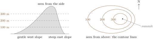
A hill sliced every 100\, m (a sketch). Seen from above, each slice gives a closed contour line around the summit. Where the slope is steep (east), the lines are close together; where it is gentle (west), they are far apart.
A hill sliced every 100 m100\,\mathrm{m} (a sketch). Seen from above, each slice gives a closed contour line around the summit. Where the slope is steep (east), the lines are close together; where it is gentle (west), they are far apart.
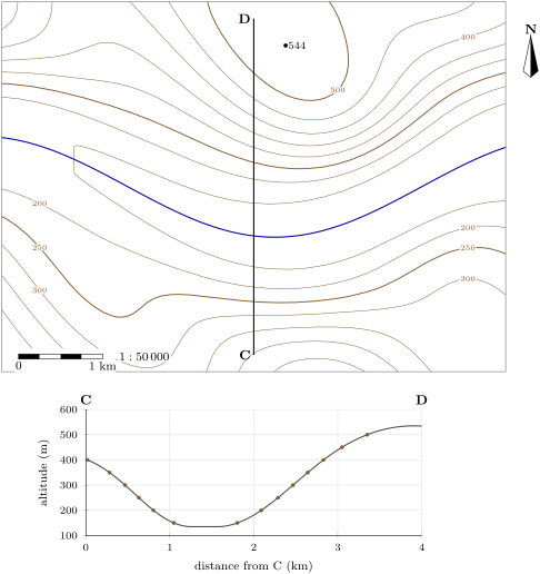
Top: a topographic map of part of the Varden Hills at 1 : 50\,000 (1 cm on the map for 500\, m on the ground). Contour interval 50\, m; the index contours, thicker, are at 250 and 500\, m. The river flows east along a flat valley floor. Bottom: the topographic profile along C–D, from south to north; the dots are the points where C–D crosses a contour line (the vertical scale is stretched three times).
Top: a topographic map of part of the Varden Hills at 1:50 0001 : 50\,000 (1 cm on the map for 500 m500\,\mathrm{m} on the ground). Contour interval 50 m50\,\mathrm{m}; the index contours, thicker, are at 250 and 500 m500\,\mathrm{m}. The river flows east along a flat valley floor. Bottom: the topographic profile along C–D, from south to north; the dots are the points where C–D crosses a contour line (the vertical scale is stretched three times).
在原文中阅读 →
