
全部书籍

专业

应用 关于 Coach 登录 开始阅读

书籍暂未推出简体中文版——当前显示英文版。

Earth and Space Sciences · 术语表

什么是 Structure contour, structure-contour map?

又称: structure contour · structure-contour map

Definition 5.10 University Earth and Space Sciences — Year 1 · 第 5 章 — Cross-Sections

A structure contour of a geological surface is a line joining points of the surface at the same elevation. A structure-contour map draws the structure contours of one surface at a regular interval, whether the surface lies underground or has been eroded away.
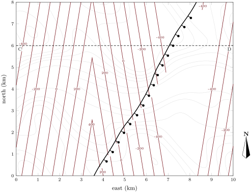
Structure contours of the base of the limestone of the Varden Hills, every 100\, m (red, labelled every 200\, m), over the topographic contours (grey). On the limbs they run nearly north–south, parallel to the strike; round the hinges of the plunging folds they form V-shapes; at the fault (ticks on the downthrown side) they stop on the two cutoff lines of the surface, which are separated by the heave, and resume offset in the hanging wall. Section C–D is dashed.
Structure contours of the base of the limestone of the Varden Hills, every 100 m100\,\mathrm{m} (red, labelled every 200 m200\,\mathrm{m}), over the topographic contours (grey). On the limbs they run nearly north–south, parallel to the strike; round the hinges of the plunging folds they form V-shapes; at the fault (ticks on the downthrown side) they stop on the two cutoff lines of the surface, which are separated by the heave, and resume offset in the hanging wall. Section C–D is dashed.
在原文中阅读 →