书籍暂未推出简体中文版——当前显示英文版。
University Earth and Space Sciences — Year 1 · 本科一年级
5Cross-Sections
An engineering company plans a tunnel under the Varden Hills, straight from west to east at a constant elevation of . Before a single metre is bored, the geologists must say which rocks the machine will cut, where it will cross the fault, and how long it will spend in the limestone, a rock that may hold open cavities and water. Nobody can see inside the hills; but the geological map of Chapter 4, a few boreholes and the geometry of planes are enough to draw a vertical slice through the ground — a cross-section — and to read the answers from it. This chapter teaches how a section is built from a map, how dips and thicknesses change when a slice is cut obliquely, how boreholes are correlated, and how a section tells the history of the rocks it cuts. It ends with the tunnel.
You already know
The attitude of a plane is given by its dip direction and its dip , and the plane through a point of elevation at the origin is ; three points of a contact fix its attitude; the V-rule reads the dip from the outcrop pattern in valleys (Chapter 4). A contour line joins points of equal elevation on a topographic map (Book 1, grade 9). Younger rocks lie on older ones, and whatever cuts a rock is younger than it (Book 1, grade 7).
5.1 From the map to the section
Definition 5.1 (Geological cross-section, topographic profile, vertical exaggeration)
A geological cross-section is a drawing of the rock units and structures in a vertical plane through the ground, along a line drawn on the map. Its upper edge is the topographic profile, the curve of ground elevation along the line. The vertical exaggeration of a section is the ratio of its vertical scale to its horizontal scale; a section is true to scale when .
Method 5.2 (Constructing a cross-section from a map)
- Draw the line of section on the map and lay the edge of a strip of paper along it; mark where each contour line crosses it, with its elevation, and where each contact and fault crosses it.
- Draw a horizontal base line of the same length and a vertical scale of elevation (choose , and write it on the section).
- Transfer each contour mark to its elevation and join the points smoothly: this is the topographic profile.
- Transfer each contact and fault to the profile, at the point where it crosses the line.
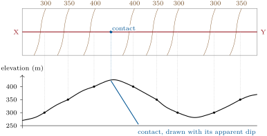
- From each such point, draw the contact into the ground with its dip in the plane of the section — its apparent dip (Section 5.2) — exaggerated by if ; use boreholes and structure contours where there are any.
- Complete the units between the contacts, respecting the order of superposition and the cuts, and add the legend, the scales, the orientation of the line and .
The section below was built by computer from the model of the Varden Hills along the line C–D, which runs due east across the map at . It shows the anticline whose core of sandstone and basement appears at , the limestone and shale on its limbs, the chalk in the syncline to the east, and the normal fault. The tunnel line, at , and the boreholes B1, B2, B3 of Section 5.4 are drawn on it.
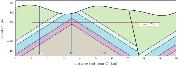

Vertical exaggeration makes thin units and gentle relief readable, but it distorts every angle: the limbs of the fold appear at about in the upper section. The next section says exactly how.
5.2 Apparent dip
Definition 5.3 (Apparent dip)
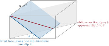
The apparent dip of a plane in a given vertical section is the angle between the horizontal and the trace of the plane in that section. It equals the true dip when the section runs along the dip direction, and is zero when it runs along the strike.
Theorem 5.4 (Apparent dip)
A plane of dip and dip direction , cut by a vertical section of azimuth , shows the apparent dip with
the plane going down in the direction when . In particular , with equality only along the dip direction.
Proof. Take the plane of Chapter 4. Along the section, a horizontal step of length in the direction is , so . The trace is a straight line that descends by per unit horizontal distance: that is . Since , . ∎
Proposition 5.5 (Angles in an exaggerated section)
In a section drawn with vertical exaggeration , a line of apparent dip is drawn at the angle with .
Proof. Over a horizontal distance the line drops by ; drawn with vertical scale times the horizontal scale, the drop appears as over the same drawn length . ∎
Example 5.6
The east limb of the Varden anticline dips toward (Chapter 4). In the east–west section C–D, , and : . Drawn with , it appears at . In the section A–B of azimuth , and as well: both sections run close to the dip direction. The fault, which dips toward , has in C–D the apparent dip .
5.3 Thickness
Definition 5.7 (True thickness, vertical thickness)
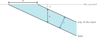
The true thickness of a layer is the distance between its base and its top measured perpendicular to the bedding. Its vertical thickness is the same distance measured along the vertical, as a vertical borehole meets it.
Proposition 5.8 (Thickness of a dipping layer)
For a layer of dip :
- ;
- on horizontal ground, if the outcrop of the layer has the width measured perpendicular to the strike, ;
- on ground sloping at the angle in the direction perpendicular to the strike, with measured along the ground, if the ground slopes the opposite way to the dip, and if it slopes the same way less steeply than the beds.
Proof. In the vertical plane perpendicular to the strike, the base and the top of the layer are two parallel lines inclined at , a distance apart. (1) A vertical segment joining them makes the angle with their common normal, so . (2)–(3) A segment of length joining them along the ground makes with the bedding the angle when the ground is flat, when the ground rises toward the dip direction’s opposite (the two inclinations add), and when it falls the same way; the distance between the parallel lines is the length of the segment times the sine of that angle. ∎
In the Varden Hills, a borehole that enters the limestone from above crosses it over of core: that is its vertical thickness. Its true thickness is . A thin unit and a thick unit can show the same outcrop width if their dips differ, and a steep layer can show a wide outcrop on a slope that runs with it: thickness is never read off a map directly.
5.4 Boreholes and structure contours
Definition 5.9 (Borehole log, correlation)
A borehole log is the record, against depth, of the rocks met by a borehole: the units, the depths of their contacts, and any measured property. Correlation is the matching of the same units and contacts from one log to another.
Three boreholes drilled on the line C–D give the following depths below the ground of the base of each unit (a dash: the contact lies above the ground, eroded):
| borehole | (km) | ground (m) | chalk | shale | limestone | sandstone |
|---|---|---|---|---|---|---|
| B1 | 1.5 | 524.02 | 388.98 | 488.98 | 668.98 | 788.98 |
| B2 | 3.5 | 380.64 | — | — | 100.48 | 220.48 |
| B3 | 5.5 | 529.98 | 394.93 | 494.93 | 674.93 | 794.93 |
B2 starts in the limestone, on the crest of the anticline; B1 and B3 start in the chalk, on its limbs. Subtracting depths from the ground elevation gives the elevations of the contacts: the base of the limestone lies at in B2 and at in B3, lower over , a slope of : the apparent dip of found above. B1 and B3 give the same thicknesses, of shale, of limestone and of sandstone: the units have the same vertical thickness on both limbs.
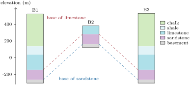
Where there are many boreholes, the shape of a buried contact is mapped with structure contours.
Definition 5.10 (Structure contour, structure-contour map)
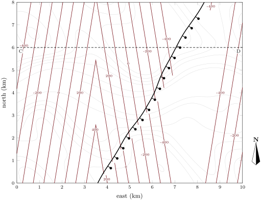
A structure contour of a geological surface is a line joining points of the surface at the same elevation. A structure-contour map draws the structure contours of one surface at a regular interval, whether the surface lies underground or has been eroded away.
For a plane, the structure contours are straight, parallel to the strike, and equally spaced: an interval between contours corresponds to the horizontal spacing . Where a surface folds, its contours bend round the fold; where a fault cuts it, they stop and resume offset, with a gap or an overlap.
Method 5.11 (Drawing a structure-contour map)
- For each borehole, and each point where the surface crops out, compute the elevation of the surface (ground elevation minus depth; at an outcrop, the ground elevation itself).
- Where the surface is close to a plane, take three points and find its attitude by the three-point method of Chapter 4; draw contours parallel to the strike, spaced apart.
- Where it is not, interpolate linearly between neighbouring points (triangles of points), and join equal elevations.
- Draw the faults first, and contour each fault block separately.
5.5 From the section to the history
A section shows not only where the rocks are but how they came to be there. The contacts between units record continuous deposition, or a gap.
Definition 5.12 (Unconformity, angular unconformity, disconformity)
An unconformity is a surface of erosion or non-deposition that separates younger rocks from older ones, and so marks a gap in the record. In an angular unconformity the older beds were tilted or folded before the younger ones were laid across their eroded edges, so the two sets of beds meet at an angle. In a disconformity the beds above and below are parallel, and the gap shows only as an erosion surface or as missing fossils or ages.
Definition 5.13 (Fault throw, heave)
The throw of a fault is the vertical component of the displacement of a marker surface across it; its heave is the horizontal component, measured in the dip direction of the fault. For a dip-slip fault of dip , .
The normal fault of the Varden Hills dips and has a throw of : its heave is . In section C–D, oblique to the fault’s dip direction, the fault appears at , and the same of throw separates the two cutoffs of a contact by along the section. To restore the section — to see the rocks as they were before the fault moved — the hanging-wall block is slid back up the fault plane by the slip; restoring the folding as well, by unbending the layers, would bring back the flat-lying cover over the eroded basement. Reading a section from the bottom up, the history of the Varden Hills follows: the schist, the granite that intrudes it, erosion, the angular unconformity, the cover laid flat, the folding, the faulting, and the erosion that made today’s hills.
History — Hutton at Siccar Point
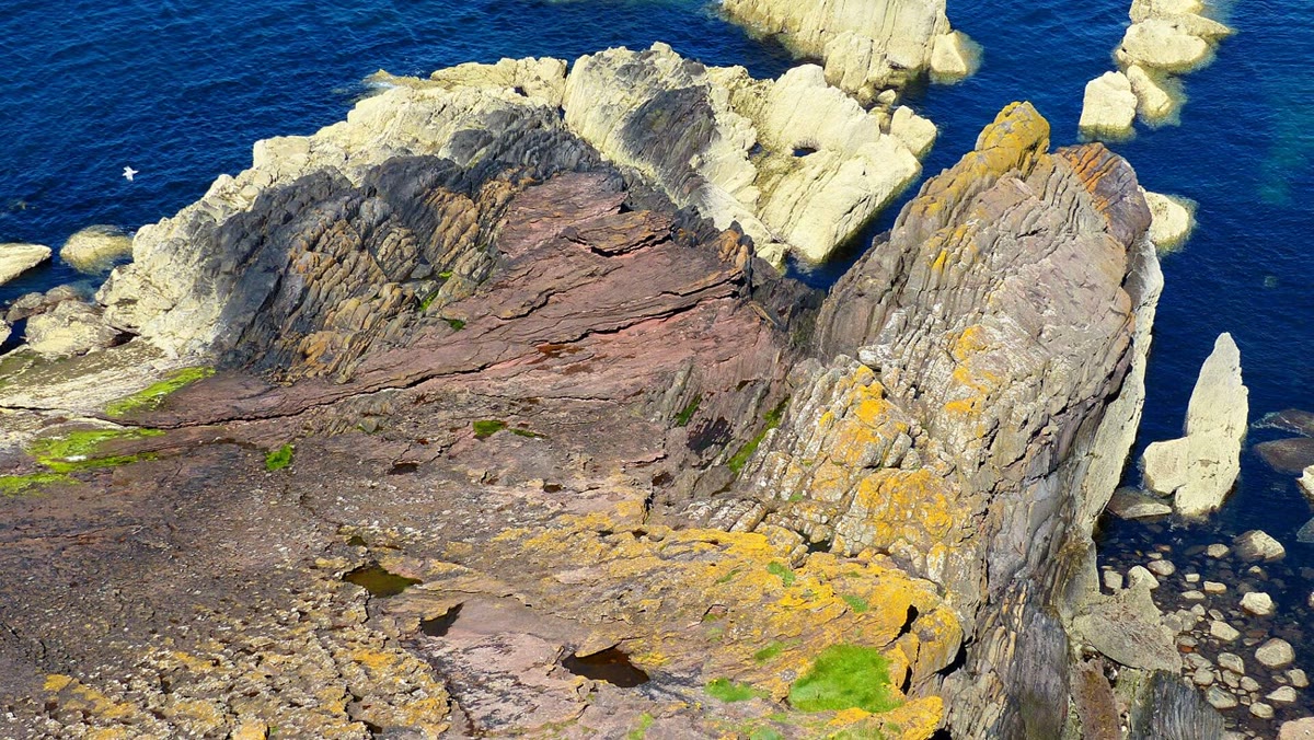
At Siccar Point, on the south-east coast of Scotland, near-vertical layers of grey sandstone and mudstone of early Silurian age are cut by an erosion surface and covered by gently inclined red breccia, conglomerate and sandstone of Late Devonian age. James Hutton described this angular unconformity in his Theory of the Earth, read to the Royal Society of Edinburgh and printed in its Transactions in 1788, then expanded in a book in 1795, and a sketch by Sir James Hall records what Hutton saw. The lower beds had been laid down flat on a sea floor, turned up on edge, raised and worn down; only then were the upper beds deposited across them, and the whole raised again. Each step demanded a span of time far longer than anyone had imagined, and Hutton’s reading of this outcrop is often cited as the moment geology discovered how old the Earth is.
In the field — Geology for a tunnel
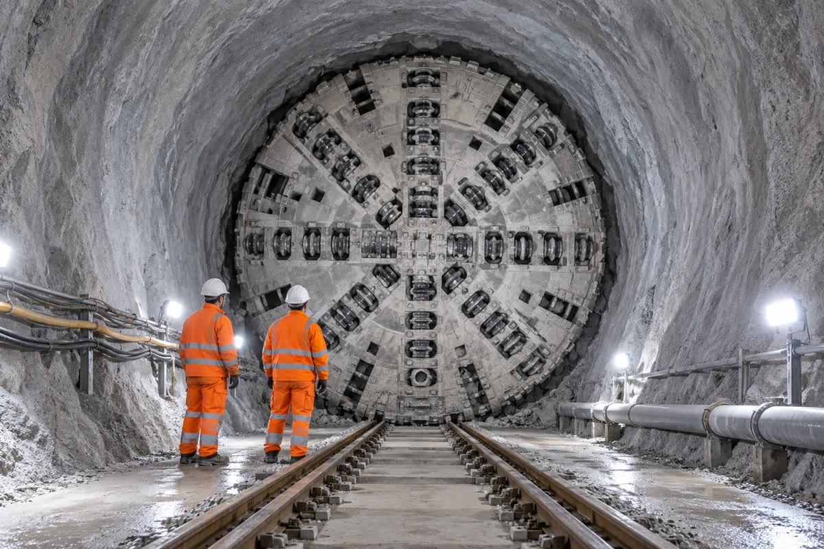
Before a tunnel is designed, engineering geologists build sections along its line from the geological map, from boreholes drilled at intervals along the route, and from geophysical surveys. They predict each unit the tunnel will cut, the faults it will cross, and where water may enter. During boring, the geologists of the contractor log the rock exposed at the face at every advance, compare it with the prediction, and update the section; probe holes drilled ahead of the machine test the ground before the machine reaches it, especially near a predicted fault or in limestone that may hold cavities. A fault zone of crushed rock is a classic hazard, all the more when the same rock lies on both sides and nothing in the face warns of it.
5.6 Exercises
Exercise 5.1 ★
A section is drawn from a map at the scale 1:25 000, with a vertical scale of for . What is its vertical exaggeration?
Solution
Solution of Exercise 5.1.
At 1:25 000, on the map is on the ground. The vertical scale is for , so the vertical scale is times the horizontal one: .
Exercise 5.2 ★
A bed dips toward . What is its apparent dip in a vertical section of azimuth ? Of azimuth ?
Exercise 5.3 ★
A vertical borehole crosses of sandstone whose beds dip . What is the true thickness of the sandstone?
Solution
Solution of Exercise 5.3.
.
Exercise 5.4 ★
A contact dipping in the plane of a section is drawn with vertical exaggerations of 2, 3 and 5. At what angles does it appear?
Solution
Solution of Exercise 5.4.
. With : ; with : ; with : . The angle grows much less than itself, and never reaches .
Exercise 5.5 ★★
A layer dips . Its outcrop is wide, measured perpendicular to the strike. Compute its true thickness (a) on flat ground; (b) on ground sloping at the opposite way to the dip, the width being measured along the ground; (c) on ground sloping at the same way as the dip.
Solution
Solution of Exercise 5.5.
(a) . (b) . (c) . The same outcrop width can mean thicknesses differing by more than a factor of two: the slope of the ground must always be taken into account.
Exercise 5.6 ★★
A bed shows an apparent dip of to the north in a north–south section, and of to the east in an east–west section. Find its dip direction and its true dip.
Solution
Solution of Exercise 5.6.
With dip direction and dip , the theorem gives in the north–south section () , and in the east–west section () . Dividing, , ; adding the squares, , . Both apparent dips are smaller than the true dip, as they must be.
Exercise 5.7 ★★
The base of the limestone on the east limb dips . What is the horizontal spacing of its structure contours drawn every ? Check it on the structure-contour map.
Solution
Solution of Exercise 5.7.
. On the map, the structure contours of the east limb are indeed a little less than half a kilometre apart, equally spaced and parallel: the limb is a plane.
Exercise 5.8 ★★
From the borehole table, compute the elevation of the base of the shale in B1 and B3. Above B2 the shale has been eroded: from the vertical thickness of the limestone, find the elevation its base would have there, and the apparent dip of that contact between B1 and B2 in section C–D. What does the comparison of B1 and B3 tell about the fold?
Solution
Solution of Exercise 5.8.
B1: ; B3: . Above B2, the base of the shale is the top of the limestone, above its base: , higher than the ground (), which is why it is eroded there. Between B1 and B2 the contact rises by over : a slope of , an apparent dip of . B1 and B3, at the same distance on either side of B2, find every contact at the same elevation within : the fold is symmetric about a vertical axial plane at , its two limbs dipping equally, and no fault cuts the section between them.
Exercise 5.9 ★★
A normal fault dipping toward has a throw of . Compute its heave. In a vertical section of azimuth , what are the apparent dip of the fault and the separation of the two cutoffs of a horizontal bed along the section?
Solution
Solution of Exercise 5.9.
Heave . In the section of azimuth , and : the fault appears with the apparent dip . The cutoffs of a horizontal bed are apart vertically on that trace, hence apart along the section, more than the heave, since the section crosses the fault obliquely.
Exercise 5.10 ★★★
For a bed dipping , in which section directions is the apparent dip half the true dip, that is ? Show that the apparent dip varies little near the dip direction and fast near the strike.
Solution
Solution of Exercise 5.10.
, so : the sections of azimuths (and the opposite directions, where the bed rises). The apparent dip is , , and for , , , , but , , and for , , , . Indeed, differentiating , , which is zero at and equals at : a section a little off the dip direction shows nearly the true dip, while near the strike every degree of azimuth changes the apparent dip by almost a degree.
Exercise 5.11 ★★★
A borehole crosses the limestone of the east limb (true thickness , dip toward ). What length of core does it recover (a) if vertical; (b) if inclined at below the horizontal toward ; (c) inclined at toward ? (Hint: the length is , where is the angle between the borehole and the normal to the bedding.)
Solution
Solution of Exercise 5.11.
The beds dip east, so the normal to the bedding, followed downward, is tilted from the vertical toward the west, toward . (a) A vertical borehole makes the angle with it: , the vertical thickness. (b) A borehole plunging toward is tilted from the vertical on the same side as the normal: , , and the core is long. (c) Toward it is tilted on the other side: , , and the core is long. The core is shortest, equal to , when the borehole runs along the normal, plunging toward .
Exercise 5.12 ★★★
At an angular unconformity, the beds below dip toward and the beds above dip toward , with the same strike. Rotate the whole outcrop about the strike to bring the upper beds back to horizontal: what was the dip of the lower beds when the upper ones were deposited? Write the history of the outcrop in order.
Solution
Solution of Exercise 5.12.
In the east–west vertical plane, with the angles measured from the east, the upper beds rise toward the east at and the lower beds go down toward the east at . Rotating the outcrop about the strike by , east side down, makes the upper beds horizontal and brings the lower beds to : they were vertical when the upper beds were deposited. History, from the oldest event: the lower beds are deposited flat; they are turned up on edge, to the vertical, and raised; their edges are eroded to a surface; the upper beds are deposited across that surface; the whole is tilted by down to the west; erosion cuts today’s ground surface. It is the history of Hutton’s outcrop at Siccar Point.
5.7 Problem: A tunnel under the Varden Hills
Problem 5.1
Weekend problem — which rocks a tunnel will cut, where it will meet the fault, and how much limestone it will bore
The tunnel runs due east along the line C–D () at the constant elevation of , from to . The ground elevation along C–D is, every kilometre from :
| (km) | 0 | 1 | 2 | 3 | 4 | 5 | 6 | 7 | 8 | 9 | 10 |
| (m) | 509 | 556 | 467 | 370 | 435 | 534 | 501 | 455 | 406 | 339 | 405 |
Use the borehole table of the chapter, the section C–D drawn with , the attitude of the east limb (dip toward ; the west limb is its mirror image, dipping toward ), and the normal fault, which dips toward , has a throw of , and passes through the point , , .
Part I — The profile and the units.
- What are the greatest and the smallest thicknesses of rock above the tunnel at the kilometre points between and ?
- On the printed section, of horizontal distance measures and of elevation measures . Check that .
- From log B2, find the elevation of the base of the sandstone on the crest of the anticline.
- In which unit is the tunnel at ?
- Compute the elevation of the base of the limestone in B1 and B3.
- From the section, list in order the units the tunnel crosses from to .
Part II — Dips in the section.
- Compute the apparent dip of the east limb in C–D from its attitude.
- Check it from the elevations of the base of the limestone in B2 and B3.
- At what angle is the east limb drawn in the section with ?
- Compute the apparent dip of the fault in C–D.
- Why is the apparent dip of the limbs in C–D so close to their true dip, and that of the fault less so?
Part III — The fault.
Show that, on the plane , the fault lies at
- Where does the tunnel meet the fault?
- Compute the heave of the fault, and the separation of the cutoffs of a contact along C–D.
- Which block is downthrown, and which unit lies at tunnel level on each side of the fault?
- Why is the fault a hazard that the tunnelling crew could not see coming from the rock at the face? How do the engineers guard against it?
Part IV — The limestone.
- What is the vertical thickness of the limestone in B1?
- What is its true thickness?
Show that, west of the fault on C–D, the base of the sandstone lies at
- The tunnel is in the limestone when its base lies below and its top above. Show that this happens for .
- Give the four points where the tunnel enters and leaves the limestone.
- Show that the length bored on each limb is , where is the vertical thickness and the apparent dip, and compute it.
- What total length of limestone does the tunnel bore through?
Solution
Solution of Problem 5.1.
1. The thickness above the tunnel is : largest at , ; smallest at , .
2. of elevation measures and of distance : .
3. .
4. In B2 the base of the limestone is at and the base of the sandstone at : the tunnel, at , is in the sandstone.
5. B1: ; B3: .
6. From west to east: chalk, shale, limestone, sandstone (in the core of the anticline), limestone, shale, and chalk again as far as , through the syncline and across the fault.
7. ; : , down toward the east.
8. : .
9. .
10. ; : .
11. The limbs dip toward or , only from the line of section, and ; the fault dips toward , from it, and .
12. The fault plane is . With , , so , and .
13. At : , that is from C.
14. Heave ; separation along C–D .
15. The fault dips east-south-east and is normal: the hanging wall, to the east, is downthrown. At tunnel level the chalk lies on both sides of the fault: west of it, the chalk of the syncline; east of it, chalk brought down .
16. The tunnel stays in chalk across the fault, so no change of rock at the face announces it; only a zone of crushed rock, and perhaps water, does. The engineers predict its position from the section (here ), drill probe holes ahead of the machine as it approaches, and prepare support for the crushed zone.
17. .
18. .
19. On the crest () the base of the sandstone is at (question 3); it goes down on both limbs with the apparent dip of question 7, that is by per metre of horizontal distance from the axis.
20. The base of the limestone is above the base of the sandstone, at with , and its top higher, at . With : the base is below when , and the top above it when .
21. and : the tunnel is in the limestone from to and from to .
22. Along a horizontal line, the base and the top of the limestone, apart vertically and both sloping at , are crossed a horizontal distance apart: on each limb, the same to rounding as .
23. : the tunnel bores through about of limestone, more than a fifth of its length, in two stretches of on either side of the sandstone core of the anticline.