সব বই

পেশাদার

1 Markets I: The Ecosystem and Exchange-Traded Marketsবাজার অনলাইন 2 Markets II: Rates, FX and Creditবাজার অনলাইন 3 Markets III: Commodities, Energy and Cryptoবাজার অনলাইন 4 Quantitative Methodsপদ্ধতি অনলাইন 5 Derivatives and Volatilityডেরিভেটিভস অনলাইন 6 Rates, Credit, XVA and Riskসুদহার, ঋণ ও ঝুঁকি অনলাইন 7 Research Craft: Predictors, Backtests, Measurement, Portfoliosগবেষণা অনলাইন 8 Strategies I: Equities and Futuresকৌশল অনলাইন 9 Strategies II: Volatility, Relative Value, Macro and the Bank Desksকৌশল অনলাইন 10 Microstructure and Executionএক্সিকিউশন অনলাইন 11 Market Making and High-Frequency Tradingমার্কেট মেকিং অনলাইন 12 Machine Learning for Marketsমেশিন লার্নিং অনলাইন 13 Low-Latency Softwareপ্রযুক্তি অনলাইন 14 Networks, Hardware and Trading Infrastructureপ্রযুক্তি অনলাইন 15 Research, Data and Risk Platformsপ্রযুক্তি অনলাইন 16 The Desk and the Firmপ্রতিষ্ঠান অনলাইন 17 The Industry: Firms, Roles and Careersক্যারিয়ার অনলাইন 18 Interviews I: Maths, Probability and Speedক্যারিয়ার অনলাইন 19 Interviews II: Markets, Trading Games and the Final Roundক্যারিয়ার অনলাইন 20 Interviews III: Codeক্যারিয়ার অনলাইন
অ্যাপ পরিচিতি Coach সাইন ইন পড়া শুরু করো

বইগুলো এখনো বাংলা ভাষায় পাওয়া যায় না — ইংরেজি সংস্করণ দেখানো হচ্ছে।

Earth and Space Sciences · পরিভাষা

Hazard map কী?

Definition 29.4 Primary & Middle School Earth and Space Sciences · অধ্যায় 29 — Living with Natural Risks

A hazard map shows the places that a natural hazard can reach, often with several levels of danger. It is drawn from what the hazard has done in the past and from the shape of the ground.
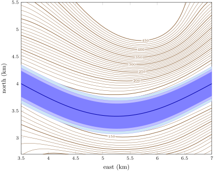

The floodplain of the river of the Varden Hills, which flows east. Each shade is the ground that a flood would cover if it rose 2, 5 or 10\, m above the normal level of the river: each zone contains the smaller ones. The zones stay narrow because the sides of the valley rise quickly from its flat floor. The thin lines join points at the same height, every 10\, m, labelled every 50\, m; such maps are the subject of . The floodplain of the river of the Varden Hills, which flows east. Each shade is the ground that a flood would cover if it rose 2, 5 or 10\, m above the normal level of the river: each zone contains the smaller ones. The zones stay narrow because the sides of the valley rise quickly from its flat floor. The thin lines join points at the same height, every 10\, m, labelled every 50\, m; such maps are the subject of .
The floodplain of the river of the Varden Hills, which flows east. Each shade is the ground that a flood would cover if it rose 2, 5 or 10 m10\,\mathrm{m} above the normal level of the river: each zone contains the smaller ones. The zones stay narrow because the sides of the valley rise quickly from its flat floor. The thin lines join points at the same height, every 10 m10\,\mathrm{m}, labelled every 50 m50\,\mathrm{m}; such maps are the subject of Chapter 32.
প্রসঙ্গসহ পড়ো →
