
সব বই

পেশাদার

1 Markets I: The Ecosystem and Exchange-Traded Marketsবাজার অনলাইন 2 Markets II: Rates, FX and Creditবাজার অনলাইন 3 Markets III: Commodities, Energy and Cryptoবাজার অনলাইন 4 Quantitative Methodsপদ্ধতি অনলাইন 5 Derivatives and Volatilityডেরিভেটিভস অনলাইন 6 Rates, Credit, XVA and Riskসুদহার, ঋণ ও ঝুঁকি অনলাইন 7 Research Craft: Predictors, Backtests, Measurement, Portfoliosগবেষণা অনলাইন 8 Strategies I: Equities and Futuresকৌশল অনলাইন 9 Strategies II: Volatility, Relative Value, Macro and the Bank Desksকৌশল অনলাইন 10 Microstructure and Executionএক্সিকিউশন অনলাইন 11 Market Making and High-Frequency Tradingমার্কেট মেকিং অনলাইন 12 Machine Learning for Marketsমেশিন লার্নিং অনলাইন 13 Low-Latency Softwareপ্রযুক্তি অনলাইন 14 Networks, Hardware and Trading Infrastructureপ্রযুক্তি অনলাইন 15 Research, Data and Risk Platformsপ্রযুক্তি অনলাইন 16 The Desk and the Firmপ্রতিষ্ঠান অনলাইন 17 The Industry: Firms, Roles and Careersক্যারিয়ার অনলাইন 18 Interviews I: Maths, Probability and Speedক্যারিয়ার অনলাইন 19 Interviews II: Markets, Trading Games and the Final Roundক্যারিয়ার অনলাইন 20 Interviews III: Codeক্যারিয়ার অনলাইন
অ্যাপ পরিচিতি Coach সাইন ইন পড়া শুরু করো

বইগুলো এখনো বাংলা ভাষায় পাওয়া যায় না — ইংরেজি সংস্করণ দেখানো হচ্ছে।

Earth and Space Sciences · পরিভাষা

Meridional overturning circulation; thermohaline circulation; deep-water formation কী?

অন্য নাম: meridional overturning circulation · thermohaline circulation · deep-water formation

Definition 29.11 University Earth and Space Sciences — Year 1 · অধ্যায় 29 — The Circulation of the Ocean

The meridional overturning circulation (MOC) of an ocean basin is its circulation in the latitude–depth plane, obtained by adding up the northward flow across the whole width of the basin. At a given latitude its strength is the maximum of the overturning streamfunction, the northward transport integrated from the surface down to a given depth, in sverdrups; in the Atlantic it is the AMOC. The older name thermohaline circulation describes the same deep circulation as one driven by differences of temperature and salinity. Deep-water formation is the sinking of surface water, made dense by cooling and by the salt left behind when sea ice forms, to intermediate or abyssal depths.
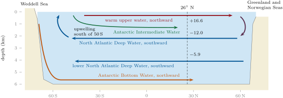
The overturning circulation of the Atlantic in a meridional section (schematic, depth exaggerated). Warm upper water flows north, gives its heat to the atmosphere and sinks in the Greenland and Norwegian Seas; North Atlantic Deep Water returns south at depths of a few kilometres and is brought up south of 50 S by the Ekman divergence under the westerlies. Antarctic Intermediate Water spreads north above it, Antarctic Bottom Water along the bottom, beneath the lower North Atlantic Deep Water. Numbers at 26 N: mean transports in sverdrups measured by the moored array, 2004–2024, northward positive, for the layers 0–800\, m, 1100 to 3000\, m and 3000 to 5000\, m.
The overturning circulation of the Atlantic in a meridional section (schematic, depth exaggerated). Warm upper water flows north, gives its heat to the atmosphere and sinks in the Greenland and Norwegian Seas; North Atlantic Deep Water returns south at depths of a few kilometres and is brought up south of 50∘50{}^{\circ} S by the Ekman divergence under the westerlies. Antarctic Intermediate Water spreads north above it, Antarctic Bottom Water along the bottom, beneath the lower North Atlantic Deep Water. Numbers at 26∘26{}^{\circ} N: mean transports in sverdrups measured by the moored array, 2004–2024, northward positive, for the layers 0–800 m800\,\mathrm{m}, 1100 to 3000 m1100\text{ to }3000\,\mathrm{m} and 3000 to 5000 m3000\text{ to }5000\,\mathrm{m}.
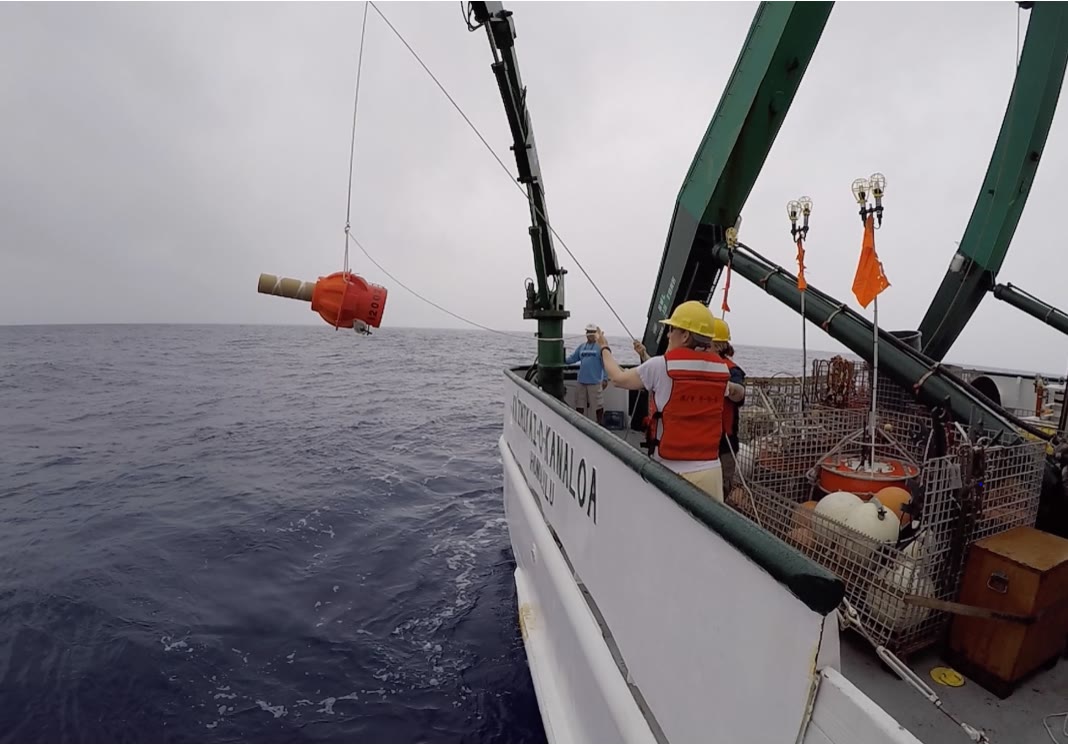
A deep-ocean profiling float (the orange instrument hanging from the crane) being lowered from a research vessel in 2018; once released, it sinks to its working depth and surfaces at regular intervals to send its data. (Unidentified NOAA photographer, public domain, via Wikimedia Commons.)
প্রসঙ্গসহ পড়ো →