书籍暂未推出简体中文版——当前显示英文版。
High School Earth and Space Sciences · 10–12 年级
1Measuring the Earth
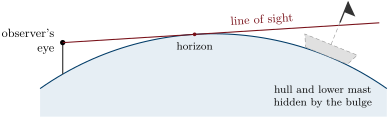
Stand on a beach and watch a ship sail away towards the open sea. It does not simply shrink until it is too small to see: first its hull disappears, as if it were sinking, then the lower part of its superstructure, and the top of its mast goes last. The sea between you and the ship is not flat; it bulges. More than twenty-two centuries ago, a scholar of Alexandria turned a similar observation — the length of a noon shadow — into a measurement of the size of the whole planet. This chapter follows that measurement and those that came after it: the chains of triangles that surveyors stretched across countries, the expeditions sent to the Arctic and to the equator to find out whether the Earth is flattened, the birth of the metre, and the satellites with which the planet is measured today.
You already know
A place on the Earth is located by its latitude, its angle north or south of the equator, and its longitude, its angle east or west of a reference meridian; meridians join the poles, parallels circle the Earth parallel to the equator (Book 1). In a uniform medium light travels in straight lines, and the rays that reach the Earth from the very distant Sun are parallel (the physics books). In a right triangle, the sine of an acute angle is the opposite side divided by the hypotenuse, its cosine the adjacent side divided by the hypotenuse, its tangent the opposite side divided by the adjacent side (the mathematics books).
1.1 A round Earth
Long before anyone could look at the Earth from space, several observations showed that it is round.
- Ships over the horizon. A ship sailing away disappears from the bottom up, in every direction and on every sea: the surface of the sea is curved everywhere.
- The shadow on the Moon. During an eclipse of the Moon, the Earth’s shadow falls on the Moon. Its edge is always an arc of a circle, whatever the time of night; only a sphere casts a round shadow in every direction.
- The stars change with latitude. A traveller going north sees the Pole Star climb higher above the horizon, and stars of the southern sky disappear below it: the traveller’s horizon tilts as the traveller moves over a curved surface.
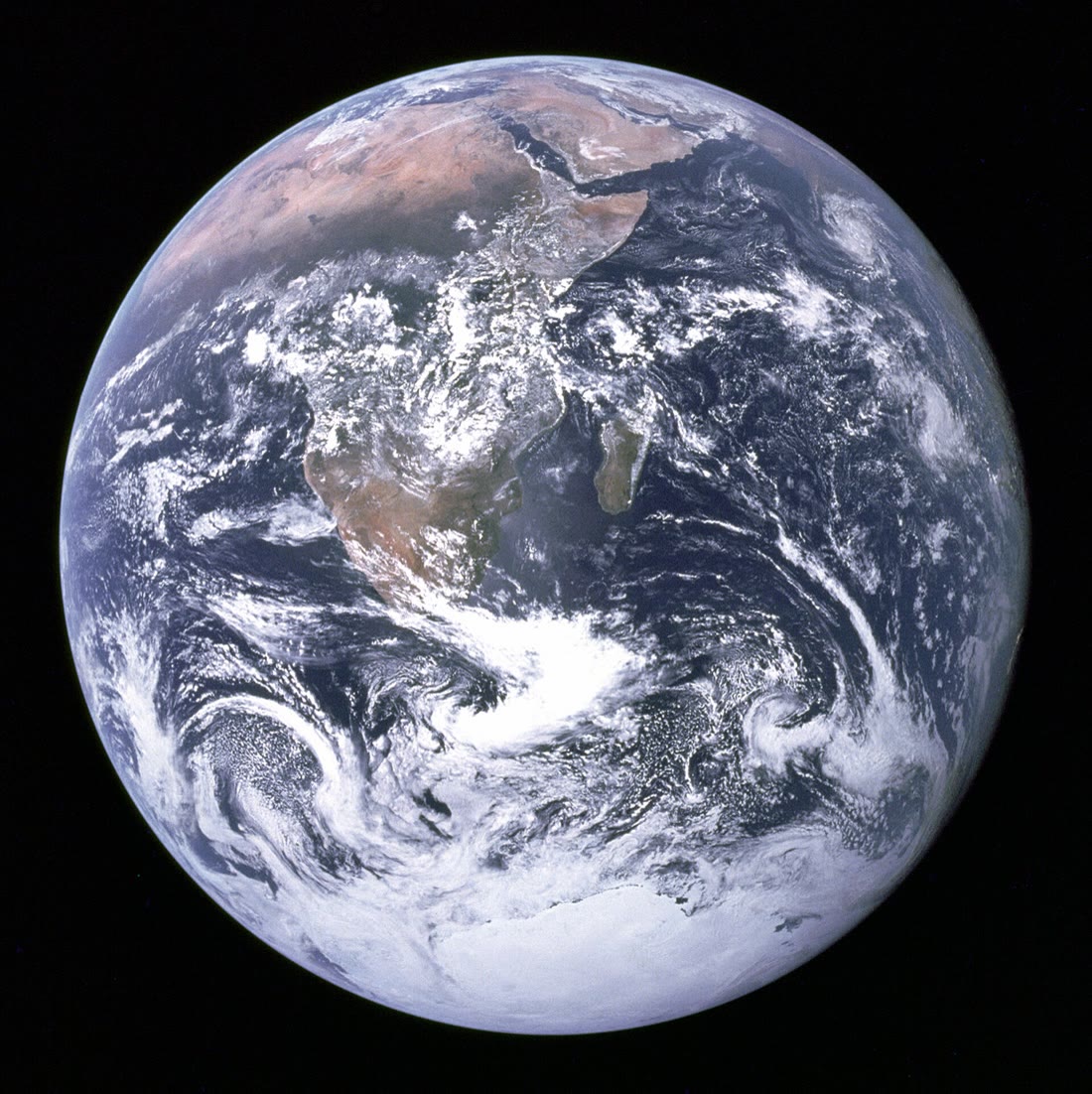
- Circumnavigation and the view from space. Ships, then aircraft, have travelled around the world in every direction; since the 1960s the whole round planet has been photographed.
1.2 Eratosthenes measures the Earth
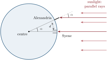
Eratosthenes of Cyrene (276–194 BC) was the librarian of Alexandria. He had heard that at Syene, the present Aswan, far up the Nile, the Sun lit the whole bottom of a well at noon on the day of the summer solstice: it was then exactly overhead. At Alexandria, at the same moment, a vertical stick cast a short shadow: the Sun’s rays made an angle of about with the vertical, one fiftieth of a full circle.
Proposition 1.1 (Eratosthenes’ relation)
If two places lie on the same meridian, a distance apart, and the Sun’s rays at noon make angles with the vertical that differ by (in degrees), the circumference of the Earth is
Proof. The Sun is so far away that its rays reaching the two places are parallel. At each place the vertical points towards the centre of the Earth. In the figure, the ray reaching the stick and the radius through Syene are two parallel lines, and the radius through Alexandria crosses both: the angle between the stick and the ray and the angle at the centre between the two radii are alternate angles, hence equal. The arc is the same fraction of the whole circumference as the angle is of a full turn: . ∎
Method 1.2 (Measuring a circumference from two shadows)
- Choose two places on (nearly) the same meridian and measure the north–south distance between them.
- At local noon on the same day, measure at each place the angle between a vertical stick and the Sun’s rays: , where is the height of the stick and the length of its shadow. Never look at the Sun itself: the angle is read from the shadow alone.
- Take the difference of the two angles and apply .
Example 1.3 (Eratosthenes’ numbers)
Eratosthenes took the distance from Alexandria to Syene to be 5000 stadia, a Greek unit of length. With of a circle,
How long was a stadion? Historians still debate it. With , ; with , . The true meridian circumference is : either way, Eratosthenes was within a few per cent.
Remark 1.4 (What was assumed)
Eratosthenes assumed a spherical Earth, a Sun far enough for its rays to be parallel, Syene exactly on the tropic (where the Sun can be overhead), and Syene due south of Alexandria. Each was nearly but not exactly true: Aswan lies about of longitude east of Alexandria. What matters is the north–south part of the distance, the one along the meridian.
1.3 Triangulation
To measure a long distance on the ground with a chain or a rod is slow, and across rivers, forests and mountains impossible. Angles, on the other hand, can be measured very precisely with a telescope on a graduated circle, pointed in turn at two distant signals. From the eighteenth century on, surveyors used this to measure whole countries.
Definition 1.5 (Geodesy)
Geodesy is the science that measures the shape and the size of the Earth and the positions of points on its surface, and follows how they change with time.
Definition 1.6 (Triangulation)
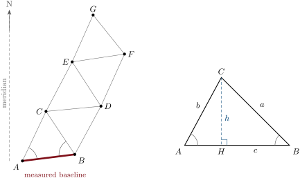
Triangulation locates distant points by a chain of triangles: one side, the baseline, is measured on the ground with great care; all the angles of the triangles are measured from their corners; every other side is then computed.
The computation rests on one relation between the sides and the angles of any triangle. In a triangle , write , , for the sides opposite the corners , , , and , , also for the angles at these corners.
Proposition 1.7 (The sine rule)
In any triangle ,
Proof. Draw the height from , meeting the line at (second panel of the figure below); write . In the right triangle , , so . In the right triangle , , so . Hence , that is . (If the angle at is obtuse, falls beyond and the angle of the right triangle at is , which has the same sine.) The same argument with the height from gives . ∎
Method 1.8 (Computing a triangulation chain)
- In the first triangle , the baseline and the angles at and are measured; the third angle is (and its measurement checks the others).
- The sine rule gives the two other sides: and .
- A computed side becomes the known side of the next triangle, and so on along the chain.
- Finally, the north–south part of each side is computed with the cosine of its angle to the meridian, and the parts are added.
Example 1.9 (One triangle)
A baseline is measured; from the signal is seen at from the direction of , from at from the direction of . Then and
No distance but the baseline was walked.
Example 1.10 (The meridian of the metre)
In March 1791 the metre was defined as one ten-millionth of the distance from the pole to the equator along a meridian. To find that distance, two astronomers, Jean-Baptiste Delambre and Pierre Méchain, measured by triangulation the meridian arc from Dunkirk, on the North Sea, to Barcelona, on the Mediterranean — almost seven years of work, Delambre in the northern two thirds, Méchain in the southern third. The two towns differ by of latitude; on the modern ellipsoid the arc between their parallels is long. Knowing the length of an arc and its difference in latitude gives the length of a degree; the shape of the Earth then gives the whole quarter meridian. Platinum standards of the new metre were made in 1799 and kept in the national Archives.
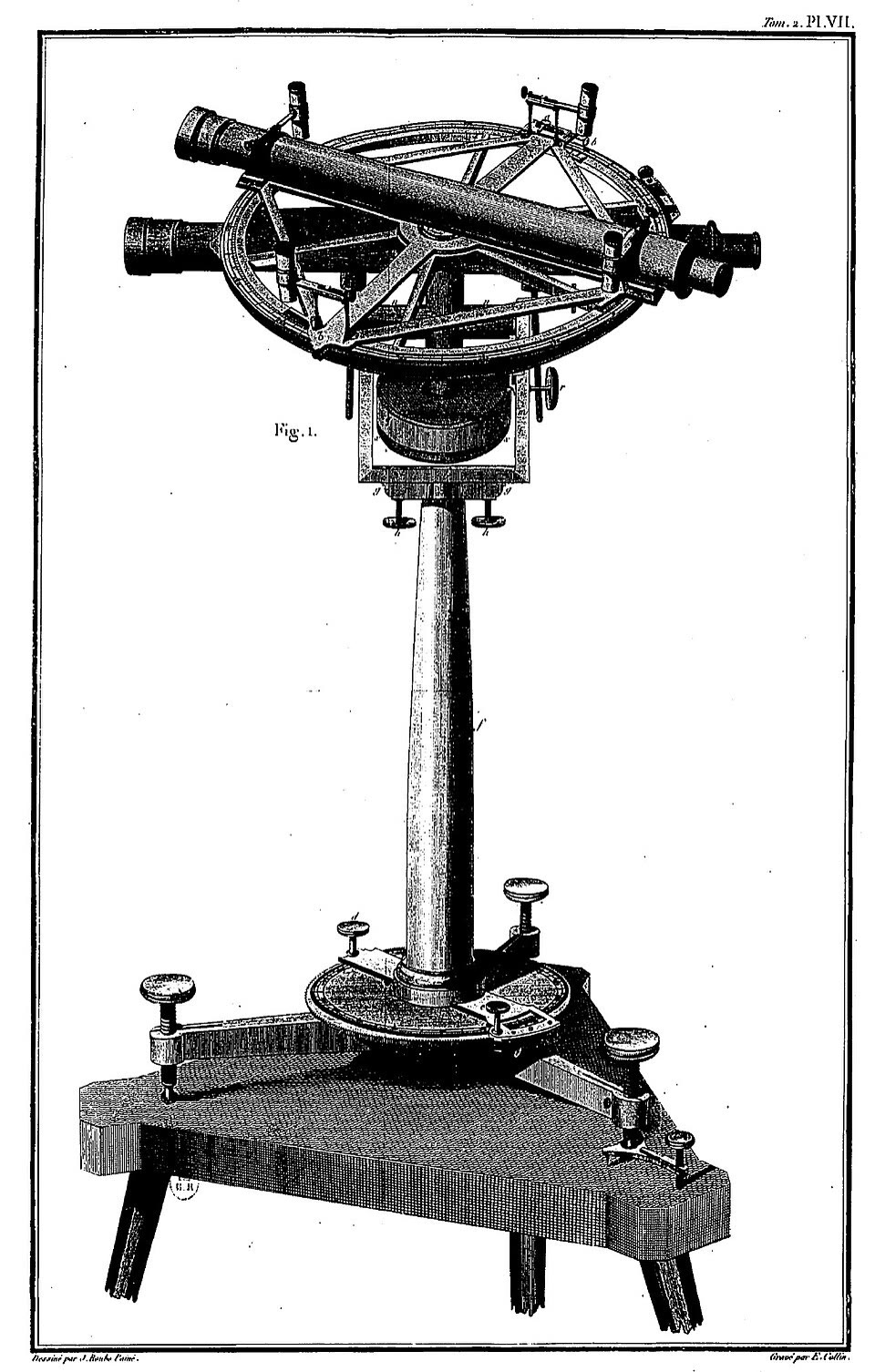
History — The repeating circle
The angles of the meridian of the metre were measured with a repeating circle, an instrument built by Jean-Charles de Borda: two telescopes on a graduated circle, pointed alternately at two signals many times over, so that the errors of reading the graduation are divided by the number of repetitions.
1.4 A flattened Earth
Around 1687, Isaac Newton argued from his theory of gravitation that a rotating Earth must be a spheroid flattened at the poles and bulging at the equator. Measurements of degrees of the meridian made by the astronomers of the Paris Observatory seemed to say the opposite: an Earth elongated at the poles. The question was settled by measuring the length of one degree of latitude as far apart as possible.
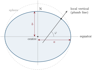
Latitude is measured from the stars: it is the angle between the local vertical and the plane of the equator. On a flattened Earth the surface is less curved near the poles than near the equator. Where the surface is less curved, one must travel farther along it for the vertical to turn by one degree: a degree of latitude is longer near the poles.
History — Lapland and Peru
In 1735 the Paris Academy of Sciences sent an expedition to the equator, in the Spanish province of Peru (now Ecuador); it worked there for nine years, until 1744. In 1736–1737 a second expedition, led by Pierre-Louis Moreau de Maupertuis with the young mathematician Alexis Clairaut, measured a degree of the meridian in Lapland, near the Arctic Circle. The Lapland degree came out at 57 437 toises (the old unit of length; about ), the Peru degree at only 56 737 toises: the degree is longer near the pole, and Newton was right. The two numbers implied a flattening of about — too large, as later surveys showed, but the question of the sign was settled.
Definition 1.11 (Reference ellipsoid and flattening)
A reference ellipsoid is the surface obtained by rotating an ellipse about its short axis, chosen to fit the shape of the Earth as closely as possible. Its equatorial radius is , its polar radius , and its flattening is
Proposition 1.12 (The dimensions of the Earth)
The reference ellipsoid used by satellite positioning (WGS 84) has
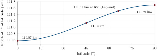
The polar radius is shorter than the equatorial radius. The equator is long and a meridian, from pole to pole and back, ; the quarter meridian, from the equator to a pole, is . One degree of latitude is long at the equator and at the poles. A degree of longitude is long on the equator and shrinks towards the poles about as .
Example 1.13 (A degree of longitude)
A parallel at latitude is a circle whose radius is the distance from the axis, about . At N its circumference is about half that of the equator, and a degree of longitude is about (the ellipsoid gives ).
Remark 1.14 (How round is round?)
A flattening of is small. On a globe across, the polar diameter would be only shorter than the equatorial one — invisible. The deepest ocean trench, nearly below sea level, would be a scratch about a quarter of a millimetre deep. For most purposes the Earth is a sphere of mean radius ; for precise positions, the ellipsoid is needed.
1.5 Geodesy today
The great triangulations of the eighteenth and nineteenth centuries have been replaced by satellites. A receiver on the ground picks up the signals of several satellites whose positions are known at every instant, and computes its own position from the travel times of the signals (Book 1). Networks of permanent receivers, fixed to bedrock all over the world, measure their positions continuously. They define the reference frame in which every map and every satellite position is given, and they move: they show the plates of the lithosphere drifting by a few centimetres a year (Chapter 13).
In the field — Measuring the ground today
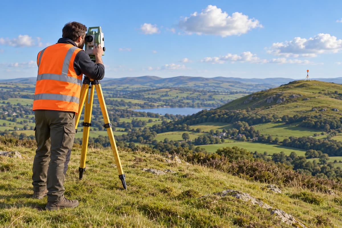
Geodesists anchor antennas on concrete pillars set in bedrock, far from buildings and trees, and record their positions every few seconds for years. They combine these with measurements from radio telescopes that observe very distant galaxies and with laser beams fired at satellites carrying mirrors. Surveyors on building sites and in the countryside still measure angles and distances with instruments on tripods, and tie them to the satellite frame.
1.6 Exercises
Exercise 1.1 ★
Give three observations, possible without leaving the ground, that show that the Earth is round. For each, explain in one sentence why a flat Earth could not produce it.
Solution
Solution of Exercise 1.1.
A ship disappears hull first: over a flat sea it would only shrink, all of it remaining visible. The Earth’s shadow on the Moon in an eclipse is always an arc of a circle: a flat disc would cast an elongated shadow when seen edge-on. Travelling north, the Pole Star rises above the horizon: on a flat Earth its height would stay almost the same.
Exercise 1.2 ★
What is geodesy? What is triangulation, and which single length must be measured on the ground in a triangulation?
Solution
Solution of Exercise 1.2.
Geodesy measures the shape and size of the Earth and the positions of points on it, and their changes with time. Triangulation locates points by a chain of triangles in which all the angles are measured; only one length, the baseline, is measured on the ground.
Exercise 1.3 ★
Eratosthenes found that the angle between the Sun’s rays and the vertical at Alexandria was of a full circle when the Sun was overhead at Syene, 5000 stadia away. Compute the circumference in stadia, then in kilometres, taking a stadion of .
Solution
Solution of Exercise 1.3.
stadia; .
Exercise 1.4 ★
One degree of latitude is about long. How long is one minute of latitude ( of a degree)? How long is the meridian from the equator to the pole, roughly?
Solution
Solution of Exercise 1.4.
. Quarter meridian: .
Exercise 1.5 ★
Using the equatorial radius and the polar radius , compute the difference of the two radii and the flattening . Express as one divided by a whole number.
Solution
Solution of Exercise 1.5.
; .
Exercise 1.6 ★★
Two towns lie on the same meridian, apart. At noon on the same day, a vertical stick high casts a shadow of in the southern town and of in the northern town. Compute the angle between the Sun’s rays and the vertical in each town, then the circumference of the Earth.
Solution
Solution of Exercise 1.6.
South: , . North: , . , so .
Exercise 1.7 ★★
In a triangle , the baseline , the angle at is and the angle at is . Compute the angle at and the lengths and .
Solution
Solution of Exercise 1.7.
. ; .
Exercise 1.8 ★★
An aircraft flies due west along the parallel N, from longitude E to longitude W. Using a degree of longitude of km, compute the distance it covers. How long would the same change of longitude be on the equator?
Solution
Solution of Exercise 1.8.
The change of longitude is . At N a degree is , so the distance is . On the equator: , twice as far.
Exercise 1.9 ★★
An observer’s eye is above a calm sea. The line of sight to the horizon grazes the sea at ; the centre of the Earth is , the eye . Explain why the triangle has a right angle at , then use Pythagoras’ theorem with to show that the distance to the horizon is about , and compute it.
Solution
Solution of Exercise 1.9.
The line of sight touches the sea at : a tangent to a circle is perpendicular to the radius at the point of contact, so the angle at is a right angle. Pythagoras: , so ; is tiny compared with , so , about .
Exercise 1.10 ★★
Read the curve of degree lengths. Between which latitudes does the length of a degree change fastest? Explain in two sentences why a degree of latitude is longer near the poles than near the equator.
Solution
Solution of Exercise 1.10.
The curve is steepest in the middle latitudes, around to , and flat near the equator and the pole. On a flattened Earth the surface is less curved near the poles; the less curved the surface, the farther one must travel for the vertical (and so the latitude) to turn by one degree.
Exercise 1.11 ★★
The meridian arc from Dunkirk to Barcelona spans of latitude and is long. Compute the mean length of a degree along it. If every degree had that length, how long would the quarter meridian be? Compare with and explain the small difference.
Solution
Solution of Exercise 1.11.
per degree; , more than the true quarter meridian. The arc is centred near , where a degree is slightly longer than the average degree from the equator to the pole ().
Exercise 1.12 ★★★
Eratosthenes measured an angle of and a distance of 5000 stadia. If his angle had been wrong by (too small), by what percentage would his circumference have been wrong, and in which direction? Which of his two measurements do you think was the less precise?
Solution
Solution of Exercise 1.12.
With : stadia instead of : about 1.4 % too large (a smaller angle for the same distance means a bigger Earth). The distance, paced by walkers along the Nile, was much less precise than the angle.
Exercise 1.13 ★★★
A chain of two triangles: in , , , . In the next triangle , built on the side , the angle at is and the angle at is . Compute , then .
Solution
Solution of Exercise 1.13.
In : , . In : the angle at is , and .
Exercise 1.14 ★★★
At what latitude is a degree of longitude half as long as on the equator? At what latitude is it one tenth as long? Explain why both answers do not depend on the size of the Earth.
Solution
Solution of Exercise 1.14.
gives ; gives . A degree of longitude at latitude is the degree on the equator multiplied by : the ratio depends only on the angle, not on the radius.
Exercise 1.15 ★★★
Use the ellipsoid’s values: a degree of latitude is at the equator and at the pole. On a sphere of the same mean radius, a degree would be everywhere. By how many metres would a surveyor who assumed a sphere be wrong over one degree at the equator, and over one degree at the pole? Why must a map that gives positions to the metre be computed on the ellipsoid?
Solution
Solution of Exercise 1.15.
At the equator: ; at the pole: . Errors of several hundred metres per degree, adding up degree after degree, are far larger than the metre: positions converted from latitudes and longitudes must use the ellipsoid.
1.7 Problem: The Metre and the Meridian
Problem 1.1
Weekend problem — from Eratosthenes’ shadow to the length of the first metre
A student retraces the history of the measurement of the Earth with modern numbers. Aswan, the ancient Syene, lies at latitude N and Alexandria at N; on the modern ellipsoid, the meridian arc between their two parallels is long. On the ellipsoid, one degree of latitude measures at the equator, at and at , and the quarter meridian is .
Part I — Eratosthenes again.
- Compute the difference of latitude between Aswan and Alexandria.
- What fraction of a full circle is it? Compare with Eratosthenes’ .
- Compute the circumference of the Earth that Eratosthenes’ method gives with these modern numbers.
- The two cities are not on the same meridian: Aswan lies about of longitude east of Alexandria. Which distance must be used in the method: the straight distance between the cities or the meridian arc between their parallels? Why?
- Why must the two shadows be measured on the same day, at local noon?
Part II — A small triangulation. A baseline is measured. From , the signal is seen at from ; from , at from . In the next triangle , the angle at is and the angle at is . The side points east of north.
- Compute the angle at in the triangle .
- Compute the side .
- Compute the side .
- Compute the angle at in the triangle , then the side .
- Compute the north–south distance between and .
- Using the degree length at , compute the difference of latitude between and , in degrees and in minutes of arc.
Part III — A flattened Earth.
- By how many metres is a degree of latitude at longer than one at the equator?
- Explain what this difference shows about the shape of the Earth.
- On the ellipsoid, and . Compute and the flattening.
- Explain why, on a flattened Earth, the plumb line at a place of latitude does not point exactly at the centre of the Earth.
Part IV — The first metre.
- According to the definition of 1791, how long should the quarter meridian be, in metres?
- The platinum metre of 1799 was made from a measured value of the meridian. If the quarter meridian is in fact , how long is one ten-millionth of it?
- Was the metre of 1799 too long or too short compared with its own definition? By what fraction?
- The platinum bar copied faithfully the length computed in the 1790s. Was the quarter meridian computed then too long or too short? Explain.
- By how many millimetres was the first metre shorter than one ten-millionth of the true quarter meridian? Compare with the thickness of a sheet of paper, about .
Solution
Solution of Problem 1.1.
1. .
2. , very close to Eratosthenes’ .
3. .
4. The meridian arc between the parallels: the difference of the noon angles is the difference of latitude, which measures only the north–south separation of the two places; the east–west part of the distance plays no role.
5. At local noon the Sun is in the plane of the meridian, the same for both places; on the same day it has the same position among the stars, so that the two angles differ only because of the curvature of the Earth.
6. .
7. .
8. .
9. The angle at is ; .
10. .
11. , that is minutes of arc.
12. : .
13. The vertical turns more slowly with distance near the pole: the surface is less curved there. The Earth is flattened at the poles and bulges at the equator.
14. ; .
15. The plumb line is perpendicular to the surface of the ellipsoid. On an ellipse the perpendicular to the curve passes through the centre only at the equator and at the poles; at it crosses the axis below the centre.
16. metres, that is .
17. .
18. Too short: the true ten-millionth is of the 1799 metre, so the 1799 metre is short by about of its length, 0.02 %.
19. Too short. The bar is one ten-millionth of the quarter meridian as computed in the 1790s; since the bar is shorter than one ten-millionth of the true quarter meridian, the computed quarter meridian was shorter than the true one.
20. m: the first metre was about too short — about two sheets of paper over a metre, an astonishing precision for a survey made with telescopes and angles across a whole country.