বইগুলো এখনো বাংলা ভাষায় পাওয়া যায় না — ইংরেজি সংস্করণ দেখানো হচ্ছে।
High School Earth and Space Sciences · শ্রেণি 10–12
18The Geology of Coal, Oil and Gas
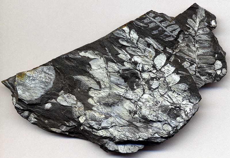
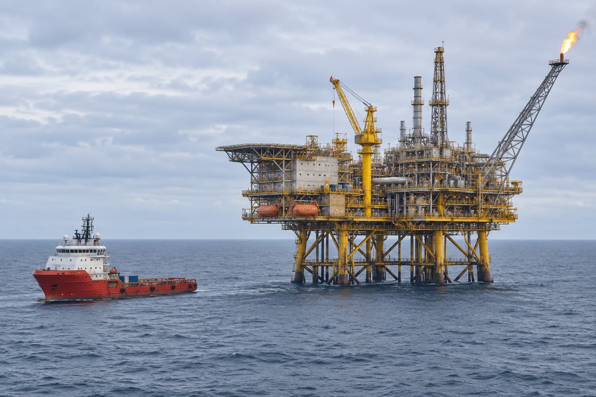
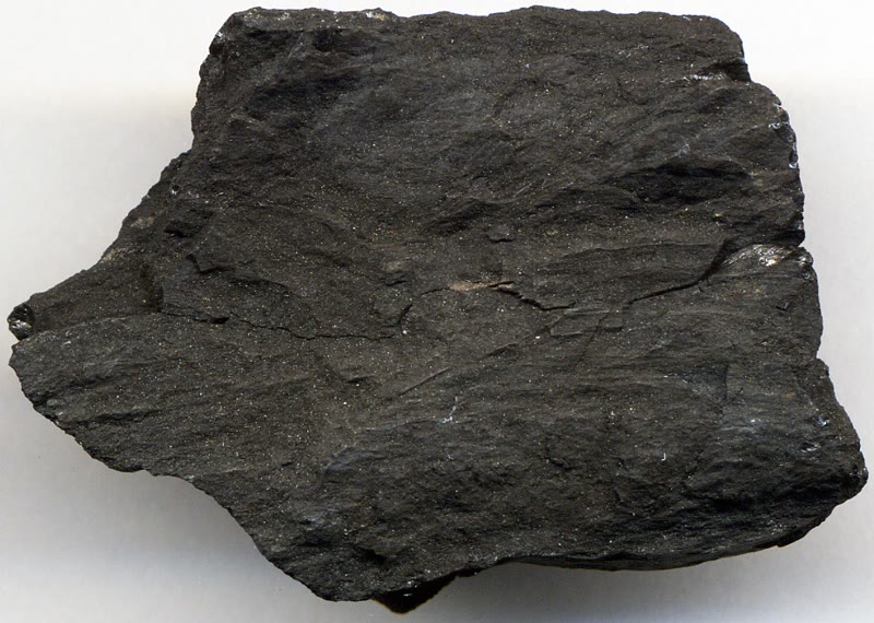
A slab of black shale taken from an old coal mine in Pennsylvania carries the leaves of fern-like plants, flattened and silvery against the dark rock. They grew in a swamp more than three hundred million years ago, in the Carboniferous; buried before they could rot, they kept their shape, and the carbon of the swamp’s plants became coal. Oil and gas, pumped today from platforms out at sea, have the same kind of origin: the remains of living things that escaped decay and were then buried and heated. This chapter follows that buried carbon from the swamp and the sea floor to the coal seam and the oil field.
You already know
Coal, oil and natural gas are fossil fuels: oil and gas are mixtures of hydrocarbons, compounds of carbon and hydrogen, and burning a fossil fuel releases energy and carbon dioxide (the chemistry books). Plants and algae make organic matter from carbon dioxide and water by photosynthesis (the biology books). Coal, oil and gas come from organic matter buried in sediments, and they are stored in sedimentary rocks (Book 1, grade 9). A rock is porous when it holds empty spaces, permeable when water can flow through it (Book 1, grade 6). Temperature rises with depth along the geotherm, by 25 to per kilometre in the first kilometres (Chapter 12).
18.1 Preserving organic matter
Most organic matter never becomes a fuel. A dead leaf or a dead alga is eaten by animals and bacteria or reacts with the oxygen of the air: within weeks or years its carbon has returned to the atmosphere as carbon dioxide. Organic matter survives only where it is cut off from oxygen — at the bottom of a stagnant swamp, or on a sea floor or lake floor whose water holds no oxygen. Buried there under more sediment, it can be kept for tens or hundreds of millions of years.
Coal comes mostly from land plants that piled up in swamps. Oil and gas come mostly from the microscopic algae and other plankton of the sea: where the surface waters are very productive, dead plankton rains onto the sea floor fast enough for some of it to escape decay, and it is buried in the mud.
Definition 18.1 (Source rock; kerogen)
Kerogen is the organic matter scattered in a sedimentary rock, in small particles that do not dissolve in organic solvents. A source rock is a sedimentary rock rich in kerogen, in which oil and gas form when it is buried and heated.
Most source rocks are shales and mudstones, laid down as muds rich in organic matter. Near the surface their kerogen stays solid: bacteria living without oxygen turn some of the organic matter into methane, but most of that methane escapes back to the surface. Making oil takes heat, and heat takes depth.
18.2 Burial and maturation
Definition 18.2 (Sedimentary basin)
A sedimentary basin is a region of the crust that sinks over millions of years, so that sediments pile up in it, often several kilometres thick.
In a sinking basin, each layer is buried deeper and deeper under the layers that pile up on top of it. As it goes down, it follows the geotherm: it is heated. Its kerogen is slowly cooked, its large molecules broken into the smaller ones of oil and gas.
Definition 18.3 (Maturation; oil window; gas window)
The maturation of a source rock is the transformation of its kerogen into oil and gas as it is buried and heated. The oil window is the range of temperature, from about 60 to , in which the kerogen mostly forms oil. Beyond about , in the gas window, it forms mostly methane.
Because the temperature rises with depth, the oil window is also a range of depths. Where the geotherm is a straight line, it is easy to find.
Proposition 18.4 (Depth of the oil window)
Let the temperature be at the surface and rise with depth at a constant geothermal gradient : . Then the oil window lies between the depths
temperatures in . Its thickness is : the steeper the geotherm, the shallower and the thinner the window.
Proof. The top of the window is the depth where , that is ; the base is where . The difference is . ∎
With a surface at and a gradient of per kilometre, the oil window lies between and . In drill holes across the United States, the gradient averages per kilometre, in the east and in the west; a source rock usually has to be buried more than about before it makes oil. When no measurement of the kerogen is available, petroleum geologists have taken a source rock buried under more than about of younger rocks as mature.
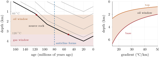
A diagram like this one is a burial-history diagram: age runs from left to right towards today, depth downwards. It turns a column of rocks, dated layer by layer, into a story.
Method 18.5 (Reading a burial-history diagram)
- Find the line of the source rock: it starts at the surface on the day the rock was laid down.
- Draw the top and the base of the oil window, as depths, from the geotherm (Proposition 18.4).
- Read the age at which the source rock’s line crosses the top of the window: the source rock begins to make oil. Read the age at which it crosses the base: from then on it makes gas.
- Compare those ages with the age of the trap: only oil and gas formed after the trap exists can be held in it.
In the Merrow Basin, the source rock enters the oil window about 117 million years ago and leaves it about 51 million years ago; its deepest burial, at , comes 20 million years ago, before uplift and erosion raise it again. Today it is still in the gas window. The weekend problem computes these ages.
18.3 From source to trap
Oil and gas are lighter than water, and the pores of buried rocks are full of water. Once formed, they are pushed out of the source rock and creep upwards, through any rock that lets them pass.
Definition 18.6 (Migration)
Migration is the slow movement of oil and gas out of the source rock where they formed, upwards through permeable rocks, driven by their lower density than the water around them.
Definition 18.7 (Reservoir rock; seal)
A reservoir rock is a porous and permeable rock in which oil and gas collect: its pores store them, and their links let them flow towards a well. A seal is an impermeable rock above the reservoir, through which oil and gas cannot pass.
Sandstones and some limestones make good reservoirs; mudstones, shales and salt make good seals. Where nothing stops them, oil and gas reach the surface, where they seep out and are oxidised: their carbon goes back to the atmosphere. They gather only where a seal is shaped so that they cannot slip past it.
Definition 18.8 (Trap)
A trap is an arrangement of reservoir rock and seal that holds oil and gas in place, closing the way up on every side.
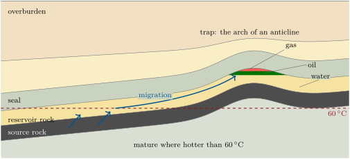
In a trap, the fluids sort themselves by density: gas on top, oil beneath, water at the bottom. The simplest trap is an anticline, an arch in the layers (folds are the subject of Chapter 20). Faults, salt domes and changes in the rocks themselves also make traps.
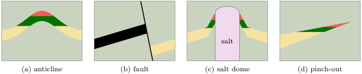
Example 18.9 (A trap in an anticline)
A seismic survey maps the top of a sandstone sealed by mudstone. It forms an arch whose crest lies below the surface. Around the crest, the deepest contour line that still closes all the way round lies at ; below it, the sandstone opens to the side. A well at the crest finds gas down to . How tall a column of oil and gas can the trap hold, and how thick is the oil?
Solution. Oil and gas fill the arch from the crest downwards; any that sinks below the last closed contour spills out to the side, at the spill point, and migrates on. The column is at most tall. If the trap is full, gas fills the top and oil the next , with water below.
Each of the pieces — a source rock, a reservoir, a seal, the rocks on top that bury the source rock, a trap — is necessary, and they must come in the right order.
Definition 18.10 (Petroleum system)
A petroleum system is a body of mature source rock together with all the oil and gas that came from it, and the elements and processes they need: the source rock, the reservoir rock, the seal and the overburden (the rocks above, which bury the source rock), and the formation of traps, the generation, migration and accumulation of oil and gas.
The order matters most. A trap that forms after the oil has gone by catches nothing: the burial-history diagram dates the generation of oil, the history of the folds and faults dates the trap, and the petroleum system works only if the trap came first. Petroleum geologists also call the time that best shows generation, migration and accumulation together the critical moment.
18.4 Where oil and gas gather
Where does a petroleum system come together? It needs a basin that sinks for a long time, waters poor in oxygen to keep organic matter, and seals. Rifts and the continental margins they grow into have all three.
When a continent begins to split, as Africa does today along the East African Rift (Book 1, grade 7), its crust stretches and breaks into blocks along normal faults (Chapter 14). Some blocks drop, others tilt, and the troughs between them fill with sediments, often several kilometres thick, and with lakes, whose muds rich in organic matter can become source rocks. When stretching stops, the thinned crust cools and keeps sinking slowly, so that the basin goes on filling. If the sea then floods into a basin only partly connected to the ocean and evaporates, it leaves thick layers of salt. Once the rift has opened into an ocean, its edges become passive margins: continental edges inside a plate, far from any plate boundary, which go on sinking and receiving sediment from the land.
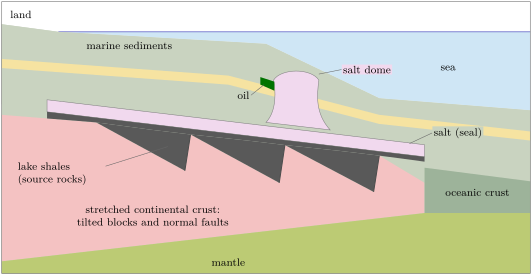
The margins of the South Atlantic were built this way. Africa and South America began to separate in the Late Triassic or Early Jurassic. Off western Central Africa, the rift troughs filled with several kilometres of sediments, among them lake shales up to thick holding up to of organic carbon by mass. In the Early Cretaceous the sea began to flood in, again and again, and evaporated, leaving more than a kilometre of salt; where the salt has stayed in place, it seals the oil and gas of the rocks below. In the Gulf of Mexico, salt that is lighter than the sediments around it has risen in domes, and the layers bent against them are traps.
18.5 Coal
Coal forms on land, mostly in swamps beside rivers and deltas, in humid climates from tropical to temperate, where plants grow fast and their remains fall into stagnant water poor in oxygen. Over centuries to millennia they pile up as peat. When a river changes course, or the sea rises, sand and mud bury the peat; buried deeper, it is squeezed and heated.
Definition 18.11 (Coal; coalification; rank)
Coal is a sedimentary rock made mostly of the remains of land plants, rich in carbon. Coalification is the transformation of peat into coal and of coal into richer coal, by burial and heating. The rank of a coal is how far coalification has gone: from lignite through subbituminous and bituminous coal to anthracite, the carbon content rises.
Lignite forms at depths from a few hundred metres to about , up to about ; bituminous coal between 1 and , up to about ; anthracite beyond and . As the rank rises, carbon makes up more and more of the coal: about 25 to in lignite, up to 86 to in anthracite. Methane formed on the way stays in the pores of the coal, which is why a coal mine can hold explosive gas. Forming a coal seam takes millions of years.
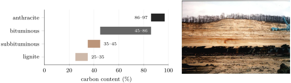
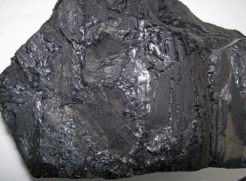
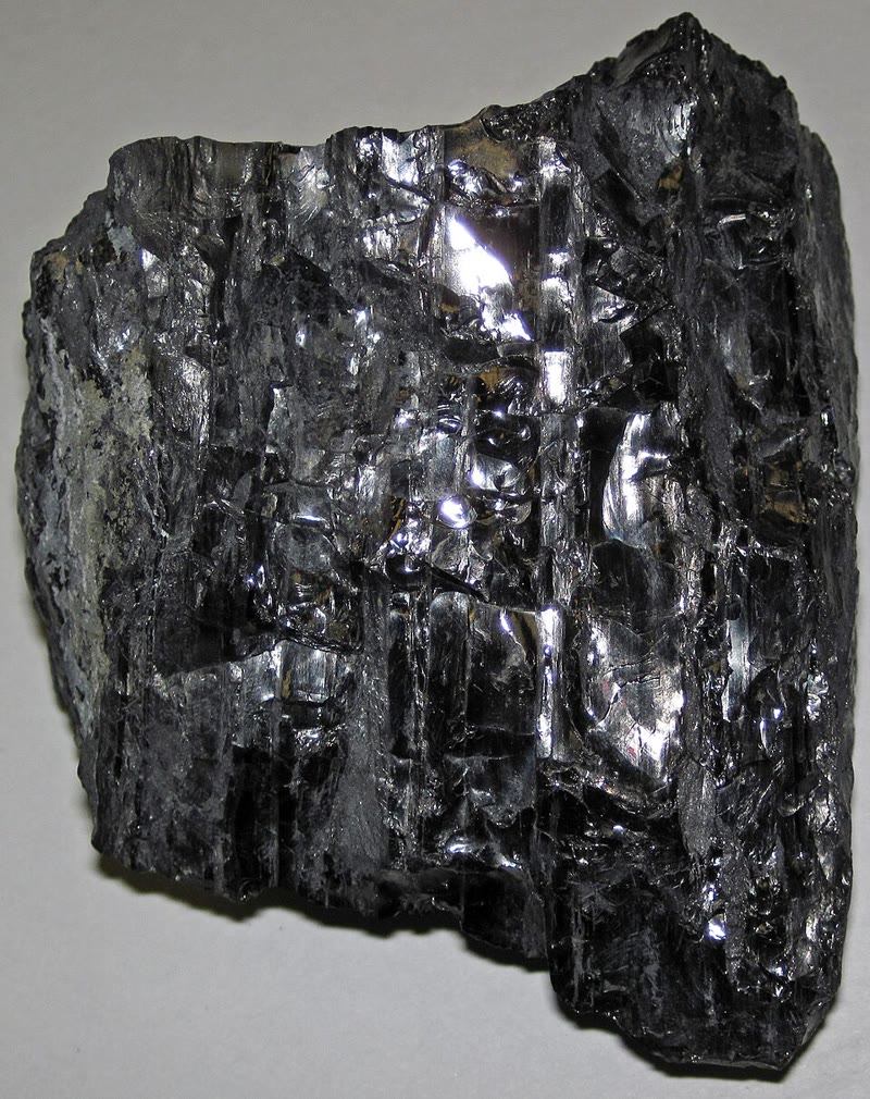
Peat loses most of its volume on the way. In a coal bed of central Utah, comparing the peat cut away by an ancient river channel with the coal missing beside it gives a ratio of thicknesses of about : every metre of that bituminous coal was once some eleven metres of peat.
18.6 Exercises
Exercise 18.1 ★
Put in order the steps that lead from plankton to oil in a trap: migration; maturation in the oil window; burial under younger sediments; dead plankton settles on a sea floor poor in oxygen; oil gathers under a seal; the organic matter becomes kerogen in a mud.
Solution
Solution of Exercise 18.1.
Dead plankton settles on a sea floor poor in oxygen; the organic matter becomes kerogen in a mud; burial under younger sediments; maturation in the oil window; migration; oil gathers under a seal.
Exercise 18.2 ★
For each rock, say whether it is more likely a source rock, a reservoir rock or a seal: (1) a dark shale rich in organic matter; (2) a well-sorted sandstone with connected pores; (3) a layer of salt; (4) a mudstone with no organic matter; (5) a limestone full of open cavities.
Solution
Solution of Exercise 18.2.
(1) Source rock. (2) Reservoir rock. (3) Seal. (4) Seal. (5) Reservoir rock.
Exercise 18.3 ★
In a basin, the surface is at and the geothermal gradient is . Between which depths does the oil window lie? How thick is it?
Solution
Solution of Exercise 18.3.
Top: ; base: . The window is thick.
Exercise 18.4 ★
(1) Put lignite, anthracite, bituminous coal and peat in order of rising rank. (2) Which has the highest carbon content? (3) Which formed at the greatest depth and temperature?
Solution
Solution of Exercise 18.4.
(1) Peat, lignite, bituminous coal, anthracite. (2) Anthracite, 86 to carbon. (3) Anthracite, beyond about and .
Exercise 18.5 ★
(1) In a trap, why does gas lie above oil, and oil above water? (2) Why must the rock above a reservoir be impermeable? Name two rocks that make good seals.
Solution
Solution of Exercise 18.5.
(1) The fluids sort themselves by density: gas is the lightest, then oil, then water. (2) Oil and gas rise because they are lighter than water; only a rock they cannot pass through stops them. Mudstone (or shale) and salt.
Exercise 18.6 ★★
Two basins have the same surface temperature, . Basin A has a gradient of , basin B of . (1) Compute the depths of the top and the base of the oil window in each. (2) A source rock lies deep in both basins. What does it make in each? (3) In which basin must a well go deeper to find oil formed in place?
Solution
Solution of Exercise 18.6.
(1) A: and . B: and . (2) At : in A, , not yet mature, no oil; in B, , in the oil window, it makes oil. (3) In basin A: oil forms there only below .
Exercise 18.7 ★★
Take the ratio of measured in central Utah between the thickness of a peat and that of the coal it became. (1) What thickness of peat made a coal seam thick? (2) Suppose the peat piled up at a year. How long did it take to accumulate? (3) Why must the swamp have been sinking all that time?
Solution
Solution of Exercise 18.7.
(1) of peat. (2) at a year: about years. (3) The peat stays only where it is under stagnant water, out of reach of oxygen; as it piles up, the ground must sink at the same pace to keep its surface waterlogged.
Exercise 18.8 ★★
Use the burial-history diagram of the Merrow Basin (surface , gradient ). The source rock was deep 120 million years ago, deep 95 million years ago and deep 20 million years ago. (1) Compute its temperature at each date. (2) At each date, was it immature, in the oil window or in the gas window?
Solution
Solution of Exercise 18.8.
(1) ; ; . (2) 120 million years ago, immature; 95 million years ago, in the oil window; 20 million years ago, in the gas window.
Exercise 18.9 ★★
The top of a reservoir sandstone forms an arch whose crest is deep; its deepest closed contour is at . A well at the crest finds gas to , then oil. (1) What is the greatest height of the column the trap can hold? (2) If the trap is full, how thick is the oil? (3) The oil and gas that keep arriving after the trap is full: where do they go?
Solution
Solution of Exercise 18.9.
(1) . (2) Gas fills , oil . (3) They spill out at the spill point, below the deepest closed contour, and migrate on upwards, to another trap or to the surface.
Exercise 18.10 ★★
When no measurement of the kerogen is available, petroleum geologists have taken a source rock buried under more than of rocks as mature. With a surface at : (1) Which gradient puts at the top of the oil window? at its base? (2) With the gradients of 25 to measured in drill holes, where does fall? Is the rule reasonable?
Solution
Solution of Exercise 18.10.
(1) Top of the window at : ; base: . (2) At the temperature is to : in the oil window, or at its base for the steepest gradients. The rule is reasonable: in most basins a source rock under of rocks has started to make oil.
Exercise 18.11 ★★
Three coal samples hold , and of carbon. (1) Give the rank of each. (2) Using the depths and temperatures given in the course, which was buried deepest? (3) The lignite has a dull, brown-black look; how does the anthracite look?
Solution
Solution of Exercise 18.11.
(1) : lignite; : bituminous coal; : anthracite. (2) The anthracite, beyond about and . (3) Black and glassy.
Exercise 18.12 ★★★
Between 120 and 95 million years ago, of mud piled up in the Merrow Basin. (1) Compute the rate of burial in metres per million years. (2) With a gradient of , by how many degrees did the source rock warm per million years? (3) Had this rate gone on, how long would the source rock have taken to cross the whole oil window? (4) The model gives about 66 million years. Why longer?
Solution
Solution of Exercise 18.12.
(1) per million years. (2) per million years. (3) The window spans : million years. (4) Burial slowed down after 95 million years ago (about 24, then 23 and per million years): the source rock warmed more slowly.
Exercise 18.13 ★★★
In the Merrow Basin, the source rock was in the oil window from about 117 to about 51 million years ago, and the anticline that traps the oil formed 80 million years ago. (1) Assume the source rock made oil at a steady rate while in the window. What fraction of its oil formed after the trap existed? (2) What became of the rest? (3) Had the anticline formed 40 million years ago, what could it hold?
Solution
Solution of Exercise 18.13.
(1) : about . (2) It migrated upwards before any trap existed above: it escaped to the surface, where it was oxidised, or gathered in some other trap. (3) By 40 million years ago the source rock had left the oil window: it made only gas, and the anticline could hold only gas from it.
Exercise 18.14 ★★★
Take the burial history of the Merrow Basin (Exercise 18.8: at 150 million years ago, at 120, at 95, at 66, depth growing steadily in between), but a hotter basin: gradient , surface . (1) Compute the depths of the top and the base of the oil window. (2) Compute the ages at which the source rock entered and left the window. (3) The anticline still forms 80 million years ago. Would it hold oil? Gas?
Solution
Solution of Exercise 18.14.
(1) Top: ; base: . (2) lies between (150 million years ago) and (120): million years ago. lies between (95) and (66): million years ago. (3) No oil: the source rock left the oil window before the anticline formed, and its oil had migrated away. It could hold gas made after 80 million years ago.
Exercise 18.15 ★★★
A seam of anthracite of the Carboniferous now crops out at the surface. The Carboniferous ended about 299 million years ago. (1) Using the depths given in the course, how deep was the seam buried at least? (2) With a surface at and a gradient of , what temperature did it reach at that depth? Is it consistent with the temperature given for anthracite? (3) What has happened to the rocks that lay above it? Give a lower bound of the average rate, in millimetres per year, assuming it all happened after the Carboniferous.
Solution
Solution of Exercise 18.15.
(1) At least . (2) , above : consistent. (3) At least of rock has been uplifted and eroded. in at most million years gives at least a year on average.
18.7 Problem: When Did the Source Rock Make Oil?
Problem 18.1
Weekend problem — dating the oil of an invented basin
A well drilled through the crest of an anticline in the Merrow Basin, an invented basin, crosses the layers below. Dated by their fossils, they record how the basin filled. From the oldest:
| interval (millions of years ago) | thickness | rocks |
|---|---|---|
| 165 to 150 | black shale rich in organic matter, then mudstone | |
| 150 to 120 | porous sandstone | |
| 120 to 95 | mudstone | |
| 95 to 66 | chalk | |
| 66 to 35 | sands and clays | |
| 35 to 20 | sands | |
| 20 to today | uplift: the top eroded |
The surface is at and the geothermal gradient is , both taken as constant. The layers keep their thickness once laid down (compaction is ignored). The anticline formed 80 million years ago. Follow the black shale at the base, laid down 165 million years ago.
Part I — The rocks.
- Which layer is the source rock, which the reservoir, which the seal?
- What made the black shale rich in organic matter?
- The Jurassic lasted from about to million years ago. In which period was the source rock laid down? The sandstone?
- What is kerogen? Why does the black shale make no oil at the surface?
- What thickness of rocks lies on top of the source rock today?
Part II — Burial against time.
- Compute the depth of the source rock 150, 120, 95, 66, 35 and 20 million years ago, and today.
- Compute the rate of burial, in metres per million years, during each of the first six intervals.
- When was the source rock deepest, and how deep?
- Why did its depth decrease over the last 20 million years?
- How deep is the base of the sandstone today?
Part III — Temperature against time.
- Compute the temperature of the source rock at each date of question 6.
- Between which depths does the oil window lie in this basin?
- Between which two dates of question 6 did the source rock pass ?
- Assuming its depth grew steadily in that interval, compute the age at which it reached .
- In the same way, compute when it reached .
Part IV — Into the window, and the trap.
- What is the highest temperature it reached? What does it make today?
- What became of the oil formed before the anticline existed?
- Assuming oil formed at a steady rate while the source rock was in the window, what fraction of it formed after the anticline existed?
- Which fluids would the well expect at the crest of the anticline, and in which order from the top?
- Conclude: when did the source rock enter the oil window?
Solution
Solution of Problem 18.1.
1. Source rock: the black shale; reservoir: the porous sandstone; seal: the mudstone above it.
2. Plankton that settled on a sea floor poor in oxygen escaped decay and was buried in the mud.
3. The source rock in the Jurassic (165 lies between 201.4 and 143.1). The sandstone began in the Jurassic and was mostly laid down in the Early Cretaceous.
4. The organic matter scattered in a sedimentary rock, insoluble in organic solvents. It makes oil only once heated to about , which takes burial.
5. .
6. , , , , , ; today .
7. ; ; ; ; ; ( per million years).
8. 20 million years ago, at .
9. The basin was uplifted and of rock eroded from its top.
10. The sandstone’s base was laid down 150 million years ago, on top of of shale and mudstone: .
11. : , , , , , ; today .
12. and .
13. Between 120 million years ago () and 95 million years ago ().
14. The temperature rose by 33 degrees in 25 million years; it took million years to rise by the 4 degrees from to : about million years ago.
15. Between 66 million years ago () and 35 (): million years ago.
16. , 20 million years ago. At today it is in the gas window: it makes mostly methane.
17. With no trap above it, it migrated up and escaped, to the surface or to other traps.
18. .
19. Gas at the top, then oil, then water.
20. The source rock entered the oil window about 117 million years ago.