书籍暂未推出简体中文版——当前显示英文版。
High School Earth and Space Sciences · 10–12 年级
20Building Mountains
Climbers who reach the top of Mount Everest, above sea level, stand on limestone. Geologists who brought samples down from the summit found in them broken pieces of trilobites, ostracods and crinoids: sea creatures that lived more than 440 million years ago, in the Ordovician. The highest rock in the world was laid down on the floor of a sea. This chapter explains how a sea floor ends up on the roof of the world: two continents collide, and the crust between them is squeezed, folded, stacked and thickened into a mountain range.
You already know
A plate of oceanic lithosphere, made at a ridge, sinks back into the mantle at a trench; its slab pulls it down (Chapter 15). The continental crust is thick and light, about on average against for the mantle beneath it, so it floats high, and a thick crust stands higher than a thin one, over a root (Chapters 19 and 12). A fault is a break along which the two blocks have moved; at a normal fault the block above the fault plane has moved down, as where the crust is stretched at a slow ridge (Chapter 14).
20.1 From subduction to collision
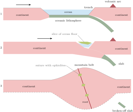
An ocean that is consumed at a trench faster than it is made at its ridge shrinks. A continent riding on the sinking plate comes nearer the trench at the speed of the plate, and in the end it arrives there. The oceanic lithosphere ahead of it has gone down; the continent cannot follow it, because its crust is too light to sink into the denser mantle. Subduction stops. The two continents are squeezed against each other, and the slab that hung from the ocean floor eventually breaks off and sinks into the mantle.
Definition 20.1 (Continental collision)
A continental collision is the meeting of two continents at a convergent plate boundary, once the oceanic lithosphere between them has been subducted. Neither continent sinks: the crust between them is deformed and thickened into a mountain belt.
20.1.1 The trace of a vanished ocean
When the ocean has closed, the two continents are welded along a line.
Definition 20.2 (Suture)
A suture is the line, or narrow zone, along which two continents have been joined by a collision, once subduction between them has stopped: the trace of a former plate boundary. It marks where the ocean between them used to be.
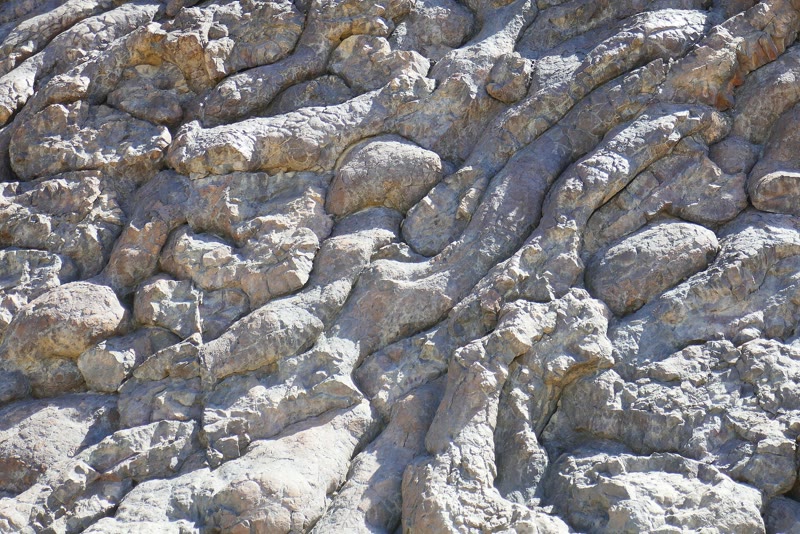
What marks a suture? Along many of them lie bodies of rock that belong nowhere on a continent: from top to bottom, marine sediments, pillow basalts, a mass of vertical dykes standing side by side, gabbro, and at the base peridotite of the mantle: the layers of the ocean floor (Chapter 14), with the top of the mantle beneath them.
Definition 20.3 (Ophiolite)
An ophiolite is a piece of oceanic lithosphere — sediments, pillow basalts, sheeted dykes, gabbro and mantle peridotite — pushed onto continental crust.
An ophiolite is stranded ocean floor: a slice of the vanished ocean, pushed onto a continent instead of sinking with the rest. The mountains raised by a collision commonly hold some ocean crust and upper mantle, because that is where an ocean closed. In southern Tibet, ophiolites strung out along the Indus–Tsangpo suture are remnants of an ocean called the Neo-Tethys, which lay between India and the region of Lhasa; a gabbro there has been dated at 243 million years.
20.2 Shortening the crust
Squeezed from the sides, a body of rock breaks if it is cold and brittle; if it is warm enough to behave in a plastic way, it folds. A mountain belt is full of both folds and faults.
20.2.1 Folds
Definition 20.4 (Fold; anticline; syncline; fold axis)
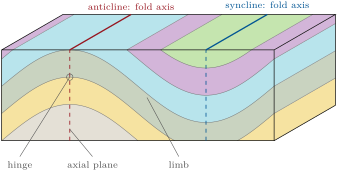
A fold is a bend in layers of rock. Its sloping sides are the limbs; they meet at the hinge, where the layers are most curved, and the line along the hinge is the fold axis. An anticline is a fold whose layers bend upward, its limbs dipping away from the axis; a syncline is a fold whose layers bend downward, its limbs dipping toward the axis.
The plane through the hinges of the successive layers is the axial plane. Anticlines and synclines usually come in pairs, the limb of one being the limb of the next. Folds come in every size, from microscopic to tens of kilometres across. Once eroded, an anticline shows its oldest layers in its core and a syncline its youngest; an anticline is not necessarily a ridge, nor a syncline a valley, because erosion follows the hard and the soft layers rather than the shape of the fold.
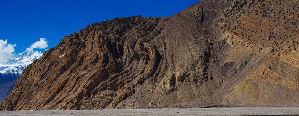
The cover of the Varden Hills is folded in the same way, much more gently. Its sandstone, limestone, shale and chalk were laid down flat, then bent into an anticline and a syncline whose limbs dip ; a later normal fault cuts them.
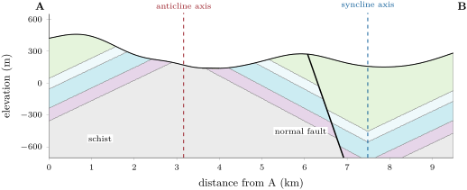
 schist
 sandstone
 limestone
 shale
 chalk vertical exaggeration Section A–B across the Varden Hills, from the south-west to the north-east. The cover rests on the schist basement and is folded into an anticline and a syncline; the normal fault, younger than the folds, drops the north-eastern block. The vertical scale is stretched 2.5 times, which makes the limbs look steeper than they are. Data: the series’ model of the region.
20.2.2 Reverse faults, thrusts and nappes
Where the crust is squeezed while cold and brittle, it breaks along faults of another kind than the normal faults of stretched crust.
Definition 20.5 (Reverse fault; thrust)
A reverse fault is an inclined fault along which the block above the fault plane has moved up relative to the block below it. Reverse faults form where the crust is squeezed. A thrust is a reverse fault with a gentle dip, less than .
A thrust can carry a sheet of rock for tens of kilometres, and then older rocks come to rest on top of younger ones, against the order in which they were laid down. In the Rocky Mountains, the McConnell Thrust has pushed a pile of sedimentary rocks about thick some from west to east: limestone about 500 million years old now lies on a mudstone about 75 million years old.
Definition 20.6 (Nappe)
A nappe is a large sheet of rock that has been carried a long distance, often tens of kilometres, over the rocks beneath it along a thrust that is nearly flat.
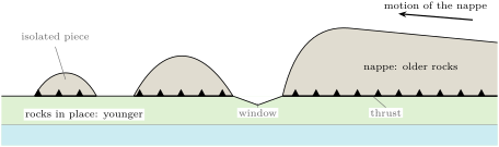
A nappe can carry rocks that formed far away, even slices of ocean floor; it can itself be folded, its layers overturned. Mountain belts pile up nappes one on top of another. Erosion later cuts holes through a nappe, opening windows onto the rocks below, and leaves isolated pieces of it standing on the younger rocks.
20.2.3 Measuring the shortening
Folds and thrusts both make the crust shorter in the direction it is squeezed.
Definition 20.7 (Shortening)
The shortening of a layer is the fraction of its length that it has lost: if it was long and now spans ,
To measure it, one needs the original length . In many folds the layers keep their thickness as they bend, sliding over one another like the pages of a bent book; such a layer is not stretched along its length. This gives the original length.
Proposition 20.8 (The shortening of a folded layer)
If a layer has folded without being stretched or squeezed along itself, its original length is its length measured along the folded layer. For a fold with straight limbs dipping at an angle ,
Proof. Unfolding the layer, without stretching it, lays it out flat with its length unchanged; so is the length along the layer. On a straight limb of length dipping at , the horizontal distance covered is (right triangle). Adding all the limbs, the layer of length spans , and . ∎
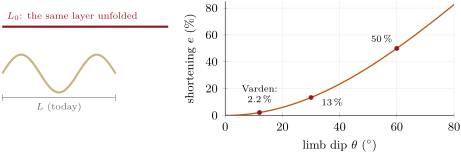
Method 20.9 (Measuring the shortening on a cross-section)
- Check that the section is drawn at true scale. If its vertical scale is stretched, dips and lengths along the layers are too large: redraw it, or correct each dip first.
- Choose one layer boundary that can be followed across the section; where a fault cuts it, join the two cut ends as they were before the fault moved.
- Measure its length along the layer, : follow it with a thread, or add up short straight pieces.
- Measure the horizontal distance between its two ends, .
- Compute ; for straight limbs of known dip, gives it at once.
Example 20.10 (The Varden folds)
The limbs of the Varden folds dip , so the cover was shortened by , about : a stretch of the region wide today was wide before folding. Measured on section A–B as drawn, the limbs would look about steep, because the vertical scale is stretched 2.5 times: is multiplied by 2.5, and . Read at face value, that would give a shortening of , more than five times too much.
Gentle folds absorb little. A tightly folded belt, with limbs dipping , has been shortened by half; and a single nearly flat thrust that has carried a nappe absorbs of shortening, as much as a very wide belt of gentle folds.
20.3 Thickening and uplift
Shortening does not destroy rock. A strip of crust squeezed to a fraction of its former width keeps its volume, so it must grow thicker: if a crust thick is shortened from a width to along the whole length of the belt, its cross-section keeps its area, , and
A crust thick shortened by becomes thick. Then isostasy does the rest: a thicker crust floats higher, over a deeper root (Proposition 12.5). With Airy’s model and the densities of the recall, a crust thicker by stands higher by , about a sixth of the extra thickness; the other five sixths form the root. The crust is to thick away from mountain belts, and 50 to thick beneath them: the higher the mountains, the thicker the crust.
This is how sea-floor limestone came to the top of Everest: laid down on the floor of a sea, it was carried north with India, stacked in the thrust sheets of the Himalaya, and lifted as the crust beneath it thickened and rose. Such a vertical movement of the crust is called uplift.
20.4 Two ranges
20.4.1 The Himalaya
The Himalaya stretch along the border between India and Tibet. About 80 million years ago India lay roughly south of Asia, across an ocean, and moved north at about a year; it met Asia between 40 and 50 million years ago, and its northward advance then slowed. Plate reconstructions show the journey in detail: built from many kinds of evidence, among them the tracks of hotspots (Chapter 13), they move the plates back in time step by step.
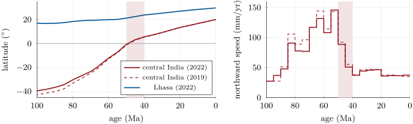
The two reconstructions agree within a few degrees. Between 65 and 50 million years ago India moved north at about a year; between 50 and 40 million years ago its speed dropped, and since 40 million years ago it has moved at about a year, less than a third as fast. Lhasa, on the Asian side, moved north too, but much more slowly.
Example 20.11 (India’s speed)
In the 2022 reconstruction, central India was at S 60 million years ago and at S 50 million years ago. One degree of latitude is . India moved north by in 10 million years: per million years, that is , about , a year.
The slowdown is read as the mark of the collision: continental crust arriving at the trench could not sink, and India was held back. The exact date of the first contact is still debated: estimates range from about 60 to 54 million years ago, and some geologists argue that India first met a chain of volcanic islands and reached Asia itself only about 34 million years ago. India has not stopped: the rotation poles of today’s plates move it toward Eurasia at about a year across the Himalaya (Chapter 13), and the pressure squeezes parts of Asia eastward.
North of the Himalaya, the Tibetan Plateau stands about high on average, over a crust about thick (Chapter 12). Between India and Tibet lies the Indus–Tsangpo suture with its ophiolites; south of it, the Himalaya are made largely of sediments laid down on India’s northern edge, then stacked, folded and faulted, the summit limestone of Everest among them.
20.4.2 The Alps, and a whole belt
The Alps have a similar history on a smaller scale: they rose where Africa collided with Europe. They too contain ophiolites, and great thrusts: at the Glarus Thrust, Permian rocks have been carried over much younger ones. The Alps and the Himalaya belong to one long belt of mountains, through the Zagros of Iran, where Africa and India have collided with Eurasia.
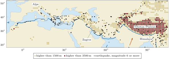
The high ground and the earthquakes follow the same narrow band. The collision is not over: the earthquakes show that the crust is still breaking along the whole belt, and that the mountains are still being built.
20.5 Exercises
Exercise 20.1 ★
Match each term to its description: anticline, syncline, thrust, nappe, suture, ophiolite. (a) a reverse fault with a gentle dip; (b) a piece of ocean floor found on land; (c) a fold whose limbs dip toward its axis; (d) the line where two continents were joined; (e) a fold whose limbs dip away from its axis; (f) a large sheet of rock carried far along a thrust.
Exercise 20.2 ★
Across a valley, the layers on the west side dip to the west and those on the east side dip to the east. (1) Is the fold between them an anticline or a syncline? (2) After erosion, are the oldest or the youngest layers found along its axis? (3) Must the valley lie over a syncline?
Exercise 20.3 ★
A layer is folded with straight limbs dipping . (1) Compute its shortening. (2) It spans today. How long was it?
Solution
Solution of Exercise 20.3.
(1) , about . (2) .
Exercise 20.4 ★
(1) Along a fault, the block above the fault plane has moved down. Is it a normal or a reverse fault, and was the crust stretched or squeezed? (2) A reverse fault dips : is it a thrust?
Solution
Solution of Exercise 20.4.
(1) A normal fault; the crust was stretched. (2) Yes: it is a reverse fault dipping less than .
Exercise 20.5 ★
(1) Put these rocks of an ophiolite in order from top to bottom: gabbro, marine sediments, peridotite, pillow basalts, sheeted dykes. (2) Why do the pillow basalts show that the rock formed under water? (3) Why are ophiolites found along sutures?
Solution
Solution of Exercise 20.5.
(1) Marine sediments, pillow basalts, sheeted dykes, gabbro, peridotite. (2) Lava forms pillows only when it cools in water. (3) An ophiolite is a piece of the ocean that lay between two continents; when they collided, slices of its floor were pushed onto their edges instead of sinking, so they are found where the ocean closed, along the suture.
Exercise 20.6 ★★
On a true-scale cross-section, a sandstone boundary is followed across four straight pieces , , and long; its ends are apart. (1) Compute the shortening. (2) If the four limbs all dip at the same angle, what is it?
Solution
Solution of Exercise 20.6.
(1) ; , . (2) , .
Exercise 20.7 ★★
The upper block of a thrust dipping has moved along the fault plane. (1) By how much has it moved horizontally? (2) By how much has it risen? (3) How wide a belt of folds with limbs dipping would absorb the same horizontal shortening?
Solution
Solution of Exercise 20.7.
(1) . (2) . (3) Such folds shorten by : the belt must have been wide before folding.
Exercise 20.8 ★★
Along the McConnell Thrust, limestone about 500 million years old lies on mudstone about 75 million years old. (1) Which principle of relative dating would mislead a geologist who ignored the fault? (2) How much older is the upper rock? (3) The thrust sheet is about thick and moved : how many times its own thickness is that?
Solution
Solution of Exercise 20.8.
(1) Superposition: read without the fault, the upper rock would be taken for the younger. (2) million years. (3) times.
Exercise 20.9 ★★
In the 2022 reconstruction, central India was at S 80 million years ago and at S 66 million years ago. (1) How far north did it move? (2) At what mean speed, in a year? (3) Compare with the summary of the US Geological Survey, about a century.
Solution
Solution of Exercise 20.9.
(1) . (2) per million years, or about a year. (3) a century is a year: the two agree within about .
Exercise 20.10 ★★
A crust thick is shortened by across a whole belt. (1) How thick does it become? (2) With and , how much higher does it stand, and how deep is its extra root?
Exercise 20.11 ★★
On a section drawn with its vertical scale stretched 3 times, a limb seems to dip . (1) What is its true dip? (2) Compute the shortening from the true dip and from the dip read on the drawing. (3) Why must sections used to measure shortening be drawn at true scale?
Solution
Solution of Exercise 20.11.
(1) The drawing multiplies by 3: , . (2) True: , ; read on the drawing: , . (3) A stretched vertical scale steepens the dips and lengthens the layers, so it makes the shortening look several times too large.
Exercise 20.12 ★★★
The rounded folds drawn in this chapter, as high as a quarter of their wavelength, have a shortening of ; their steepest dip is about . (1) A layer folded this way spans : how long was it? (2) Compute the shortening of a fold with straight limbs at . (3) Explain why the straight-limbed fold shortens more for the same steepest dip.
Exercise 20.13 ★★★
North of the Himalaya, at E N, the rotation poles give India a velocity relative to Eurasia of to the east and to the north. Over the last 5 million years, the 2022 reconstruction gives central India a northward speed greater than that of Lhasa. (1) Find the speed of India relative to Eurasia. (2) Assuming the north components can be compared, how much north–south shortening per million years is left for the region north of Lhasa? (3) Where in the chapter is a sign that this region is deforming?
Solution
Solution of Exercise 20.13.
(1) . (2) a year, that is about of north–south shortening per million years north of Lhasa. (3) Lhasa itself has moved north, and the earthquakes of the belt spread far north of the Himalaya across Asia: the crust there is still breaking.
Exercise 20.14 ★★★
In the Alps, a nappe has been carried along a thrust whose dip is close to zero. (1) What shortening did that thrust absorb? (2) What width, before folding, of folded cover like that of the Varden Hills (limbs ) would absorb the same shortening? (3) What does this show about how mountain belts absorb large convergences?
Solution
Solution of Exercise 20.14.
(1) Its dip is close to zero, so the shortening is the displacement, . (2) . (3) Large convergences are absorbed mainly by thrusts and nappes and by tight folds; gentle folds absorb very little.
Exercise 20.15 ★★★
The summit limestone of Everest was laid down on a sea floor, at least a little below sea level, and stands today at . (1) Taking the collision to have begun 50 million years ago, what is the least mean rate of uplift, in a year? (2) Compare it with India’s speed since 40 million years ago, about a year. (3) Why is the uplift of the rock probably larger than its present height?
Solution
Solution of Exercise 20.15.
(1) in years: about a year. (2) : the rise is more than two hundred times slower than India’s motion. (3) The limestone was laid down below sea level, and erosion has removed the rocks that lay above it: it has been lifted by more than its present height.
Problem 20.1
Weekend problem — India’s journey
The table gives the latitude of a point in central India and of Lhasa, north of the suture, in the 2022 plate reconstruction (negative = south). Take one degree of latitude as , and per million years as a year.
| age () | 80 | 66 | 60 | 55 | 50 | 45 | 40 | 20 | 0 |
|---|---|---|---|---|---|---|---|---|---|
| India () | 3.30 | 5.59 | 13.40 | 20.00 | |||||
| Lhasa () | 19.48 | 21.15 | 29.65 |
Part I — Latitudes and speeds.
- Check the value of for one degree, with .
- When did central India cross the equator?
- How far north did India move from 66 to 50 million years ago?
- At what mean speed?
- Compute its speed in each step from 66 to 40 million years ago (66 to 60, 60 to 55, and so on). In which step was it fastest?
Part II — The slowdown.
- Compute India’s mean speed from 40 million years ago to today.
- What fraction of its speed from 66 to 50 million years ago is that?
- Between which two dates of the table did the speed fall most?
- Why does a collision slow the plate down?
- How far north did India move from 50 million years ago to today?
Part III — Convergence absorbed.
- How far north did Lhasa move from 50 million years ago to today?
- By how much has the north–south distance between central India and Lhasa shrunk since 50 million years ago?
- What is that distance today, and what was it 50 million years ago?
- Suppose that all of this convergence was taken up by shortening the crust between the two points. What is the shortening ?
- Name the two kinds of structures that absorb such a shortening.
Part IV — The crust thickened.
- If that crust was thick 50 million years ago, how thick would it be now, keeping its cross-section?
- With and , how high would it stand above its former level?
- The Tibetan Plateau stands about high, over a crust about thick. Which crust thickness does Airy’s model give for ?
- Give one reason why the simple model of question 16 overestimates the thickening.
- Adding the distances of questions 3 and 10, how far has India travelled north since the end of the Cretaceous, 66 million years ago?
Solution
Solution of Problem 20.1.
1. .
2. Between 50 million years ago ( S) and 45 ( N): million years ago.
3. .
4. per million years: a year, about .
5. 66 to 60: ; 60 to 55: ; 55 to 50: ; 50 to 45: ; 45 to 40: ( a year). Fastest from 55 to 50 million years ago.
6. a year.
7. : less than a third.
8. From the step 55–50 (146) to the step 50–45 (89): around 50 million years ago.
9. Continental crust is too light to sink: when it reached the trench, subduction could no longer pull India along freely, and the other continent held it back.
10. .
11. .
12. .
13. Today ; 50 million years ago (and ).
14. , .
15. Folds, and reverse faults: thrusts carrying nappes.
16. .
17. ; it would stand higher by .
18. , a crust thick, close to the measured.
19. The crust does not keep its cross-section: parts of Asia are squeezed out eastward, and erosion removes rock from the top of the mountains.
20. : since the end of the Cretaceous, India has travelled about north.