বইগুলো এখনো বাংলা ভাষায় পাওয়া যায় না — ইংরেজি সংস্করণ দেখানো হচ্ছে।
High School Earth and Space Sciences · শ্রেণি 10–12
4Why Clouds Form
On a summer terrace a glass of iced water stands on a table. Within a minute its outside is covered with tiny drops, and a ring of water spreads at its foot. The water did not leak through the glass: it came out of the air, which was cooled where it touched the cold glass. A few hours later, kilometres above the plain, the same thing happens on a grand scale: bubbles of warm air rise, cool, and at a certain height the water they carry appears as the flat-bottomed heaps of white cloud called cumulus. This chapter explains how much water vapour air can hold, why rising air cools, at what height clouds form, why some days they stay flat and others they tower into thunderstorms, and how tiny cloud droplets turn into rain and snow.

You already know
Clouds are made of tiny droplets of water or crystals of ice; they are sorted into families by their shape and height, and they give rain, snow and hail, measured with a rain gauge (Book 1, grade 4). The temperature of the air falls with height through the lowest layer of the atmosphere, on average by about per kilometre; this is the environmental lapse rate, and fronts separate air masses of different temperatures (Book 1, grade 8). Pressure falls with height (the physics books). Water evaporates and condenses, and evaporation absorbs latent heat that condensation gives back (the physics books and Chapter 3).
4.1 Water vapour and saturation
Air always contains some water vapour, an invisible gas. How much it can contain depends above all on its temperature.
Definition 4.1 (Saturation; relative humidity)
Air is saturated when it contains the largest mass of water vapour it can hold at its temperature, its saturation content; any extra vapour condenses into droplets. The relative humidity of air is its content of water vapour divided by its saturation content at the same temperature and pressure, expressed as a percentage.
The water content of air is measured here in grams of vapour per kilogram of dry air (): a parcel of air that rises or sinks without gaining or losing water keeps the same content, even as it expands.
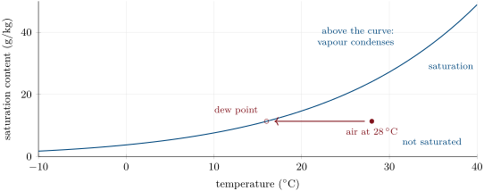
The curve rises steeply: at , at , at . Every of warming nearly doubles the water the air can hold. This is why tropical air can carry torrential rain, and why the air of a polar winter, even saturated, holds almost nothing.
Definition 4.2 (Dew point)
The dew point of air is the temperature to which it must be cooled, keeping its water content and its pressure, to become saturated.
Method 4.3 (Relative humidity and dew point from a table)
- Read in the table the saturation content at the air’s temperature.
- Relative humidity: divide the air’s water content by it.
- Dew point: find in the table the temperature whose saturation content equals the air’s water content.
Example 4.4 (A summer morning)
At the air contains . The saturation content at is , so the relative humidity is . The saturation content is at : that is the dew point. In the afternoon, the same air warmed to (saturation content ) has a relative humidity of only — with exactly the same water in it.
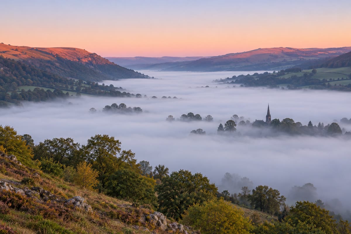
The glass of the opening is colder than the dew point of the air around it: the air touching it is cooled below its dew point and gives up water on the glass. On a clear night, grass and car roofs lose heat by radiating infrared to the sky and grow colder than the air: dew forms on them, or frost below . When a whole layer of air near the ground cools to its dew point, droplets form in the air itself: fog.
4.2 Rising air cools
Most clouds do not form because air touches something cold. They form because air rises. The pressure falls with height; a parcel of rising air expands, pushing back the surrounding air, and the energy for this work is taken from the parcel itself.
Definition 4.5 (Adiabatic cooling; dry adiabatic rate)
Adiabatic cooling is the cooling of a parcel of air that expands without exchanging heat with its surroundings. The rate at which rising unsaturated air cools in this way is the dry adiabatic rate, close to per kilometre of ascent; sinking air warms at the same rate.
Proposition 4.6 (The dry adiabatic rate)
The dry adiabatic rate is , where and is the energy that warms a kilogram of air by one degree at constant pressure: , that is . (Admitted: the proof belongs to the physics books.)
The parcel’s dew point also falls as it rises, but slowly: its water content stays the same, while the drop in pressure makes the vapour a little easier to saturate. The computation for air near the ground gives about per kilometre. The parcel’s temperature therefore closes in on its dew point by about for each kilometre it climbs.
Definition 4.7 (Condensation level)
The condensation level of a parcel of air is the height at which, rising, it becomes saturated. Water condenses above it: the condensation level is the flat base of the clouds that the rising air forms.
Proposition 4.8 (Height of the condensation level)
Air that rises from the ground with temperature and dew point (in ) becomes saturated at about
Proof. At a height (in km) the parcel’s temperature is and its dew point . It is saturated when they are equal: , so and km. One eighth of a kilometre is . ∎
Example 4.9 (An afternoon cumulus)
In the afternoon of Example 4.4, the air at the ground is at with a dew point of . Rising bubbles become saturated at : the cumulus have their flat bases about up. In the morning, at , the same air would have condensed at only : cloud bases rise through the day as the ground warms.
4.3 Stable and unstable air
Whether a rising parcel keeps rising depends on the air around it. A parcel warmer than its surroundings is lighter than the air it displaces and rises, like a hot-air balloon; a parcel colder than its surroundings sinks back.
Definition 4.10 (Stable air; unstable air)
Air is stable when a parcel pushed upwards becomes colder than the air around it, and so sinks back to where it started. It is unstable when the parcel becomes warmer than the air around it and keeps rising on its own.
The rising parcel cools at the dry adiabatic rate, per kilometre, as long as it is not saturated. Once it is saturated it cools more slowly: condensation releases latent heat into the parcel. The computation gives about per kilometre in warm air near the ground, about at , and more in the cold air higher up, where little water is left to condense; this is the saturated rate. (Its formula is derived in the university volumes.)
Method 4.11 (Is this air stable?)
- Find how fast the temperature of the surrounding air falls with height (the environmental lapse rate, from a balloon sounding).
- Compare it with the rate at which the parcel cools: the dry rate, about , below its condensation level; the saturated rate, about , above it.
- If the surroundings cool more slowly than the parcel, the parcel ends up colder: stable. If they cool faster, the parcel ends up warmer: unstable. A layer where the temperature rises with height is very stable: it stops rising air like a lid.
With the average lapse of about , air is stable as long as it is unsaturated (the parcel cools faster) and unstable once it is saturated (the parcel cools more slowly). Such air is said to be conditionally unstable: it is stable unless something lifts it up to its condensation level, and then the cloud grows on its own.
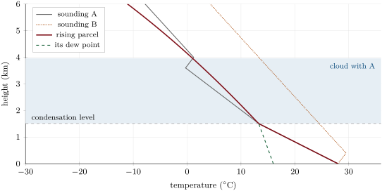
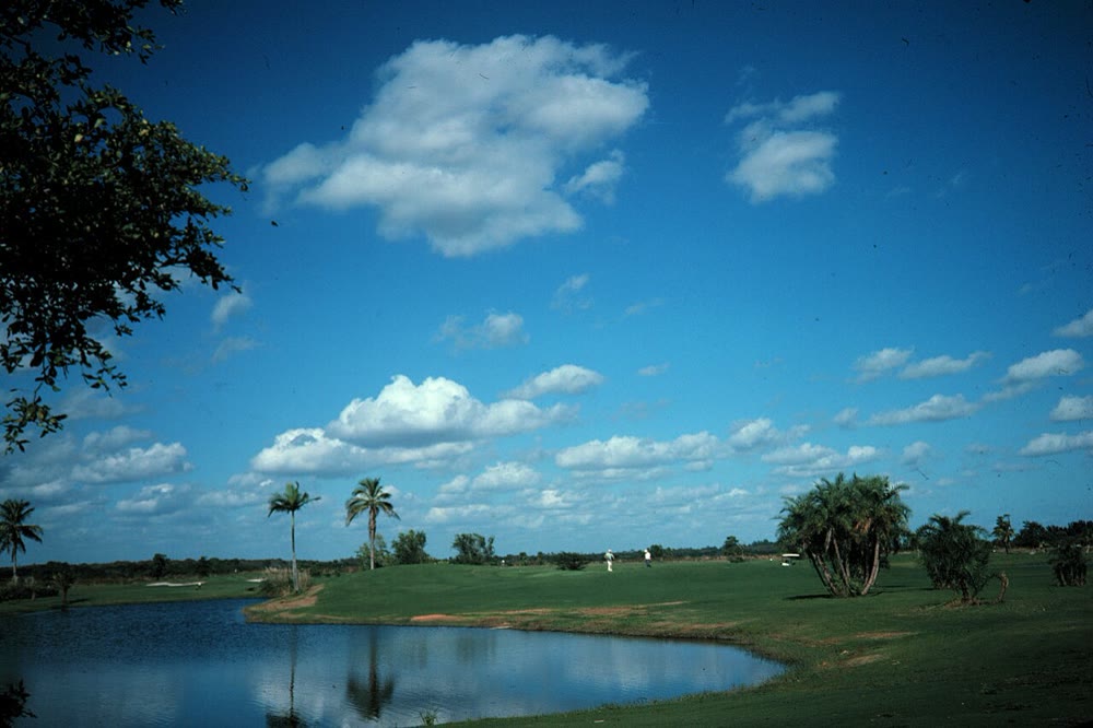
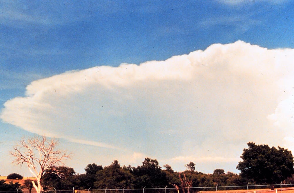
When the air is stable and is lifted all the same — over a mountain, or along a front — the clouds that form spread out in flat grey layers: stratus. When it is unstable, the clouds billow upwards in heaps: cumulus, and, when the instability reaches high enough, the cumulonimbus of thunderstorms, whose tops spread out in an anvil where they meet the very stable air above the lowest layer of the atmosphere.
4.4 Four ways to lift air
Air rises for four reasons.
- Heating from below. On a sunny day the ground warms the air above it; bubbles of warm air rise from the hottest patches. These give the afternoon cumulus.
- Mountains. Wind blowing against a mountain range is forced up its slope.
- Fronts. Where warm and cold air masses meet, the lighter warm air rises over the cold air, or the cold air pushes under it (Book 1, grade 8).
- Convergence. When winds flow together near the ground, the air has nowhere to go but up, as in the belt of rising air near the equator and at the centre of a depression.
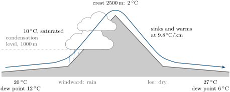
Method 4.12 (Following a parcel over a mountain)
- Find the condensation level with the 125-metre rule; up to it the parcel cools at .
- From there to the crest it cools at the saturated rate; the water that condenses falls as rain or snow on the windward side.
- Beyond the crest the parcel sinks, unsaturated: it warms at all the way down.
Example 4.13 (The warm dry wind of the lee side)
Air at sea level at , with a dew point of , is driven over a ridge high. It becomes saturated at , at about . From there to the crest it cools at the saturated rate, to about , and loses as rain about a third of its water (from to ). Coming down the other side it warms at the dry rate over : it reaches the plain at about , seven degrees warmer than it started, with a relative humidity of about . Such warm, dry winds blow in the lee of many mountain ranges.
4.5 From droplets to rain and snow
Water vapour does not condense easily in perfectly clean air. Droplets form on specks of matter.
Definition 4.14 (Condensation nucleus)
A condensation nucleus is a tiny particle suspended in the air — a grain of sea salt, dust, smoke or soot — on which water vapour condenses to form a cloud droplet.
A typical nucleus measures about , a cloud droplet about , a drop of drizzle and a raindrop about . A raindrop is a hundred times wider than a cloud droplet, so its volume is times larger: a million cloud droplets make one raindrop. Cloud droplets are so small that the slightest updraught keeps them aloft; for rain to fall, droplets must grow a hundred-fold.

Two processes make them grow.
Definition 4.15 (Warm-rain process; ice-crystal process)
In the warm-rain process, the larger droplets of a cloud fall faster than the small ones, collide with them and merge, growing as they fall. In the ice-crystal process, in the part of a cloud colder than where ice crystals and supercooled droplets (liquid below ) are mixed, the crystals grow by taking the vapour that the droplets evaporate; they fall as snowflakes, and melt into raindrops if the air below is warm.
The ice-crystal process works because the saturation content is lower over ice than over liquid water at the same temperature: at the saturation vapour pressure is over water and over ice. Air saturated for the droplets holds more vapour than ice can bear: the vapour condenses on the crystals, the droplets evaporate to replace it.
Remark 4.16 (Latent heat feeds the storm)
Every kilogram of water that condenses in a cloud gives the air about , the latent heat taken from the sea or the ground when it evaporated (Chapter 3). This heat is what makes the saturated rate slower than the dry rate and keeps a cumulonimbus rising; Chapter 5 follows it into the largest storms.
4.6 Exercises
For these exercises, use the saturation contents (in , at sea-level pressure) of the table below, the dry rate , a dew-point fall of and a saturated rate of .
| temperature () | 0 | 4 | 8 | 10 | 12 | 14 | 16 | 20 | 24 | 28 | 30 |
| saturation content () | 3.8 | 5.0 | 6.7 | 7.6 | 8.7 | 10.0 | 11.4 | 14.7 | 18.9 | 24.1 | 27.2 |
Exercise 4.1 ★
Define the relative humidity and the dew point of air.
Solution
Solution of Exercise 4.1.
The relative humidity is the air’s content of water vapour divided by its saturation content at the same temperature and pressure, as a percentage. The dew point is the temperature to which the air must be cooled, keeping its water content and pressure, to become saturated.
Exercise 4.2 ★
From the table, give the saturation content at , , and . By roughly what factor does it grow for each of warming?
Solution
Solution of Exercise 4.2.
, , and . Each multiplies it by about 2 (, , ).
Exercise 4.3 ★
Air at contains of water vapour. Find its relative humidity and its dew point.
Solution
Solution of Exercise 4.3.
Saturation content at : ; relative humidity . The saturation content is at : the dew point.
Exercise 4.4 ★
Explain why a glass of iced water “sweats” in summer, and why it does not on a very dry winter day indoors.
Solution
Solution of Exercise 4.4.
In summer the air is humid and its dew point is well above the temperature of the glass: the air touching the glass is cooled below its dew point and water condenses on it. Very dry winter air indoors has a dew point lower than the temperature of the glass: cooled against it, the air is still not saturated.
Exercise 4.5 ★
Name the four ways in which air is made to rise, with an example of each.
Solution
Solution of Exercise 4.5.
Heating from below (afternoon cumulus over sunny ground); mountains (wind forced up a range); fronts (warm air rising over cold air); convergence (winds flowing together near the equator or into a depression).
Exercise 4.6 ★★
Using Proposition 4.8, find the height of the cloud base for air at with a dew point of , and for air at with a dew point of . Which day is likely to be grey and low?
Solution
Solution of Exercise 4.6.
; . The second day: clouds form only above the ground.
Exercise 4.7 ★★
A parcel of unsaturated air leaves the ground at . What is its temperature and up, if it stays unsaturated? Sinking back from , at what temperature does it reach the ground?
Solution
Solution of Exercise 4.7.
At : ; at : . Sinking, it warms at the same rate and reaches the ground at again.
Exercise 4.8 ★★
A balloon sounding shows the temperature falling by per km. Is the air stable for an unsaturated parcel? For a saturated one? On a hot afternoon, the temperature falls by in the first kilometre above the ground: what happens to the bubbles of warm air?
Solution
Solution of Exercise 4.8.
With , both an unsaturated parcel () and a saturated one () cool faster than their surroundings: stable in both cases. With , even an unsaturated bubble cools more slowly than its surroundings: it stays warmer and keeps rising, and the bubbles of warm air rise freely.
Exercise 4.9 ★★
Saturated air at is cooled to . How many grams of water condense per kilogram of air? Where does the latent heat released go?
Solution
Solution of Exercise 4.9.
per kilogram of air. The latent heat warms the air in which the water condenses, slowing its cooling.
Exercise 4.10 ★★
How many cloud droplets across make one drop of drizzle across? One raindrop across?
Solution
Solution of Exercise 4.10.
Volumes grow as the cube of the diameter: droplets for a drizzle drop; for a raindrop.
Exercise 4.11 ★★
Explain, step by step, why fog forms in valleys rather than on the hilltops at dawn after a clear, calm night.
Solution
Solution of Exercise 4.11.
Under a clear sky the ground radiates infrared and cools, and so does the air touching it. This cold air is denser than the air above; on slopes it flows downhill and collects in the valley bottom. There it keeps cooling through the night until it reaches its dew point, and droplets form in the air itself: fog. On the hilltops the air is not as cold and stays above its dew point.
Exercise 4.12 ★★★
The dry rate is and the dew point falls at the rate (both in ). Show that the condensation level is at . Over a high plateau the dew point falls at : what does the rule “ per degree” become?
Solution
Solution of Exercise 4.12.
At height the temperature is and the dew point ; they are equal when , so . With : , and per degree.
Exercise 4.13 ★★★
Air at sea level at , with a dew point of , crosses a ridge high. Following Method 4.12, find the condensation level, the temperature there, the temperature at the crest, and the temperature at which the air reaches the plain on the other side.
Solution
Solution of Exercise 4.13.
Condensation level: ; temperature there: . Crest: . Down at the dry rate: , about seven degrees warmer than on the windward side.
Exercise 4.14 ★★★
At the saturation vapour pressure is over water and over ice. By what percentage is air saturated for the droplets oversaturated for the ice? Compare with , and say where in a cloud the ice-crystal process works best.
Solution
Solution of Exercise 4.14.
At : , oversaturated for the ice; at : , . Among these temperatures, the colder the cloud, the larger the advantage of the ice: the process works best in the cold upper part of a cloud where droplets and crystals are mixed.
Exercise 4.15 ★★★
The surrounding air cools by . A parcel starts at the same temperature as its surroundings and rises . Compute the difference between its temperature and that of the surroundings if it is unsaturated, then if it is saturated. Explain the phrase “conditionally unstable”.
4.7 Problem: A Summer Afternoon over the Plain
Problem 4.1
Weekend problem — from the morning humidity to the base of the afternoon clouds
Over a wide plain, on a summer day, the air near the ground contains of water vapour all day. It is at in the morning and in the afternoon. A balloon sounding (an invented example) gives the temperature of the air above:
| height (km) | 0 | 0.5 | 1.0 | 1.5 | 2.5 | 3.5 | 3.6 | 4.0 |
| temperature () | 28.0 | 23.1 | 18.2 | 13.4 | 6.9 | 0.4 | 1.2 |
Use the table of saturation contents and the rates given before the exercises.
Part I — Humidity.
- Give the saturation content at .
- Compute the morning relative humidity.
- Find the dew point of the air.
- Compute the relative humidity in the afternoon.
- Has the air become drier in the afternoon? Explain.
Part II — The night and the dew.
- During the night the air near the ground cools. At what temperature does dew begin to form?
- If the air cools to , how many grams of water per kilogram of air have condensed?
- Why does dew form on grass and on car roofs before it forms in the air?
Part III — The sounding.
- Compute the rate at which the temperature falls between and . Compare it with the dry rate.
- Compute it between and .
- Is the air between and stable for an unsaturated parcel? For a saturated one?
- What happens between and ? What does it do to a rising cloud?
Part IV — The cloud base.
- Compute the difference between the air’s temperature and its dew point at the ground in the afternoon.
- Compute the temperature and the dew point of a bubble of this air after it has risen , still unsaturated.
- By how much has the difference between the two shrunk? At what rate does it shrink?
- Show that this rate gives the rule “ per degree”.
- What would the cloud base have been in the morning?
- Explain why cumulus bases rise during the day.
- Write the equation stating that the bubble’s temperature equals its dew point at the height (in km).
- Solve it: at what height is the base of the afternoon cumulus?
Solution
Solution of Problem 4.1.
1. .
2. .
3. , where the saturation content is .
4. .
5. No: it holds the same . Its relative humidity fell because, warmer, it could hold more.
6. At its dew point, .
7. per kilogram of air.
8. Under a clear night sky, grass and roofs radiate infrared and become colder than the air; the air touching them is cooled below its dew point before the rest of the air is.
9. , practically the dry rate: the afternoon bubbles have mixed this layer.
10. .
11. Stable for an unsaturated parcel, which cools faster (); unstable for a saturated one, which cools more slowly ().
12. The temperature rises with height, from to : a very stable layer, which acts as a lid. The rising cloud stops there: its tops are near .
13. .
14. Temperature ; dew point .
15. From 12 to : it shrank by , a rate of per kilometre.
16. One degree of difference is closed in km, that is .
17. .
18. The dew point stays at while the air near the ground warms: the difference grows, and so does the height at which it is closed.
19. .
20. , so : the base of the afternoon cumulus is about above the plain (the exact computation with the properties of water gives ).