High School Earth and Space Sciences · Grades 10–12
5Storms and Tropical Cyclones
A hot summer afternoon ends in a storm. The sky darkens, a gust of cold wind sweeps the street, a flash lights the clouds — and you start counting: one, two, three, … nine seconds later the thunder rolls. The storm is about three kilometres away. In an hour it will be over, and the air will be cool and clean. Over the warm tropical oceans, the same ingredients — warm, humid air that rises and condenses — can organise into storms of another size altogether: tropical cyclones, hundreds of kilometres across, that last for days and bring winds strong enough to flatten forests and a rise of the sea that floods whole coasts. This chapter looks at thunderstorms, tornadoes and tropical cyclones, and at where their energy comes from.
Safety
If you can hear thunder, lightning can reach you. Go into a building or a closed car and stay there until well after the last thunder. Never shelter under an isolated tree, and keep away from hilltops, open fields and water.
You already know
Air masses, fronts, depressions (areas of low pressure) and anticyclones are drawn on weather maps with isobars, lines of equal pressure (Book 1, grade 8). A natural hazard is a natural event that can harm people and what they build (Book 1, grade 5). Sound travels in air at about , light almost instantly (the physics books). Warm, humid air that rises cools, condenses into cloud at its condensation level and releases latent heat; saturated air is often unstable (Chapter 4).
5.1 Thunderstorms
Definition 5.1 (Thunderstorm)
A thunderstorm is a storm produced by a cumulonimbus cloud, with lightning and thunder, usually with heavy showers and gusts of wind, sometimes with hail.
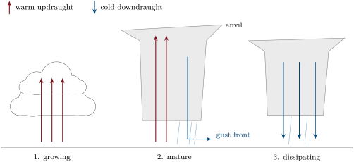
A thunderstorm grows from unstable, humid air. In its first stage a cumulus grows upwards, fed by a strong updraught; condensation releases latent heat and keeps the rising air warmer than its surroundings. In its mature stage the cloud reaches the stable air high above and spreads out in an anvil; drops and hailstones grow large enough to fall, and the falling rain drags cold air down with it: a downdraught that spreads out at the ground as a cold gust front. In its last stage the downdraught takes over the whole cloud, cutting off the supply of warm humid air, and the storm rains itself out.
Inside the cloud, collisions between ice particles carried up and down by the air separate electric charges: the cloud becomes charged, usually negatively at the bottom and positively at the top, and the ground below it gains a charge of its own.
Definition 5.2 (Lightning)
Lightning is a giant electric spark that discharges charged regions of a storm, inside the cloud, between clouds, or between the cloud and the ground. It heats a narrow channel of air so suddenly that the air expands with a shock: the sound of this expansion is thunder.
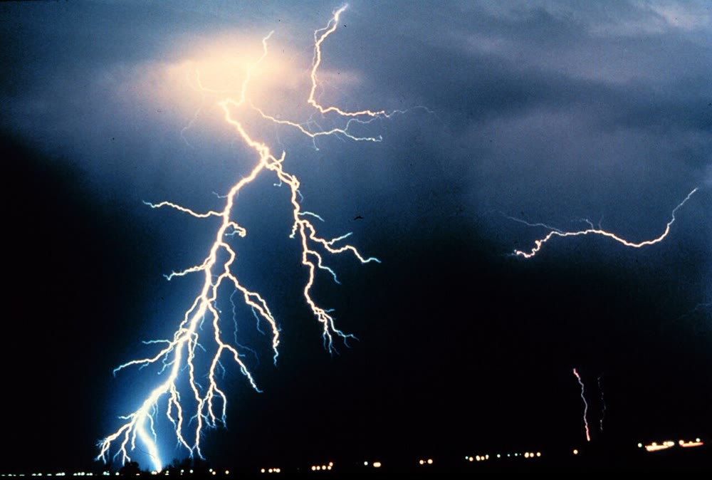
Satellites that count the flashes of light over the whole planet find about 1.4 billion lightning flashes a year, or 44 every second.
Method 5.3 (Distance of a storm from flash to thunder)
- The light of the flash arrives practically at once; the thunder travels at the speed of sound, about at .
- Count the seconds between the flash and the thunder.
- The distance is metres: about for every three seconds.
5.2 Tornadoes
Definition 5.4 (Tornado)
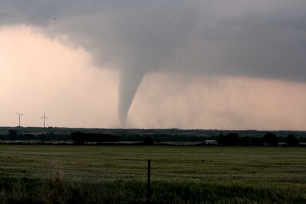
A tornado is a violently rotating column of air in contact with the ground, hanging from the base of a cumulonimbus.
The strongest tornadoes come from supercells, thunderstorms whose updraught rotates as a whole. A tornado is small and brief: typically a few hundred metres across, lasting minutes, with an average path of about . But its winds are the strongest at the Earth’s surface: a mobile radar measured about (some ) above the ground in a tornado in Oklahoma in May 1999. The United States has more tornadoes than any other country, around 1200 a year; other regions where they are frequent include the Canadian prairies, Bangladesh, northern Argentina and southern Brazil, and Britain.
5.3 Tropical cyclones
Definition 5.5 (Tropical cyclone; eye; eyewall)
A tropical cyclone is a storm, hundreds of kilometres across, that forms over a warm tropical sea around a centre of low pressure, with winds spiralling in towards the centre and bands of thunderstorms. When its sustained winds reach knots, about , it is called a hurricane in the Atlantic and the eastern Pacific, a typhoon in the western Pacific, and simply a cyclone in the Indian Ocean and the South Pacific. Its calm, nearly cloudless centre is the eye; the ring of towering thunderstorms around it, where the winds are strongest, is the eyewall.
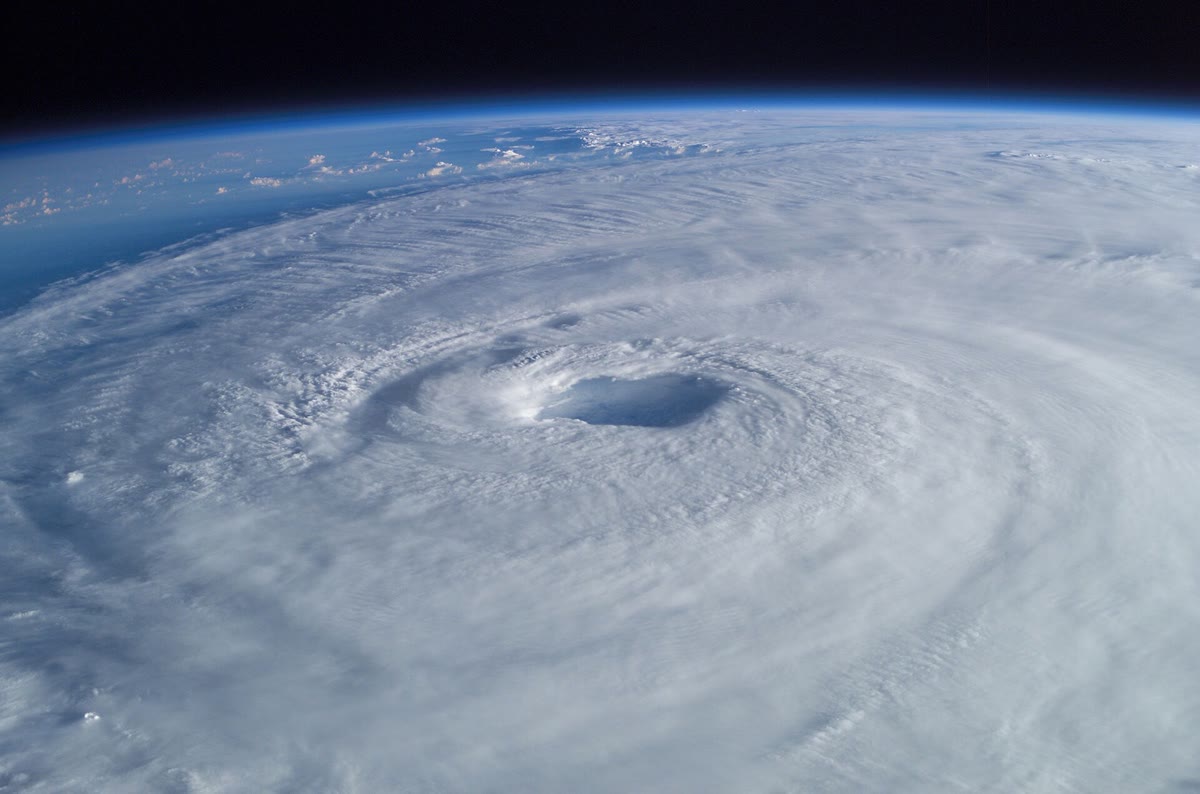
Near the sea surface, humid air flows in towards the low pressure of the centre. The Earth’s rotation deflects moving air to the right in the Northern Hemisphere: instead of going straight to the centre, the air turns around it, anticlockwise seen from above (clockwise in the Southern Hemisphere). Close to the centre it rises in the eyewall, condenses, and flows out at the top of the storm. In the eye a little air sinks, warms and dries: the sky clears.
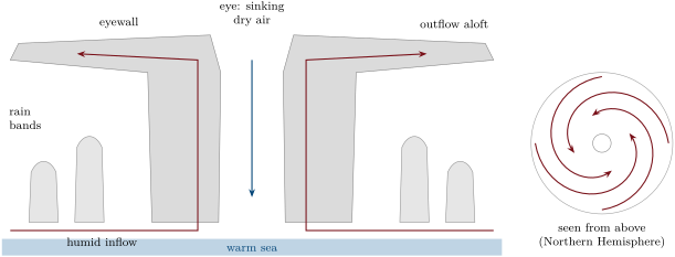
Tropical cyclones need a warm ocean: water of at least about at the surface, warm to a depth of some . They do not form on the equator itself, where the Earth’s rotation gives the inflowing air no turn: a storm must be at least about from the equator for the spin to start.
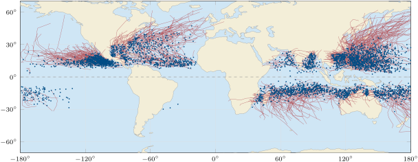
The map shows the rule at work. Of the 3 888 storms of 1980–2024, only 24 reached tropical-storm strength within of the equator. Most form between and of latitude, then drift west with the trade winds and curve away towards the poles, where the cold sea weakens them. The South Atlantic, cooler and less favourable, saw only three in 45 years. About 87 tropical cyclones form in an average year, seven in ten of them in the Northern Hemisphere, and a little over half reach hurricane strength.
Proposition 5.6 (The energy source of a tropical cyclone)
A tropical cyclone draws its energy from the warm sea: the latent heat taken up by evaporation at the sea surface is released in the eyewall and the rain bands when the vapour condenses. An average hurricane releases in this way about ; only a small fraction of it, about , goes into the kinetic energy of its winds.
Justification. An average hurricane rains a day over a circle of radius , an area of : , or , of water a day. Each kilogram that condenses releases about : a day, that is . The power of the winds is an estimate from measured wind fields, quoted from the same source. ∎
The storm works like an engine: heat taken in at the warm sea surface, given off high up in the cold upper air, part of the difference turned into the motion of the wind. This is why a tropical cyclone weakens quickly when it moves over land or over cold water: it loses its supply of evaporating water.
5.4 Intensity, winds and surges
Definition 5.7 (Saffir–Simpson scale)
The Saffir–Simpson scale sorts hurricanes into five categories by their maximum sustained wind; categories 3 to 5 are major hurricanes.
| category | knots | ||
|---|---|---|---|
| 1 | 64–82 | 33–42 | 119–153 |
| 2 | 83–95 | 43–49 | 154–177 |
| 3 | 96–112 | 49–58 | 178–208 |
| 4 | 113–136 | 58–70 | 209–251 |
| 5 | 137 or more | 70 or more | 252 or more |
The deeper the low pressure at the centre, the stronger the winds that blow around it: the pressure difference between the centre and the surroundings is what drives the air inwards.
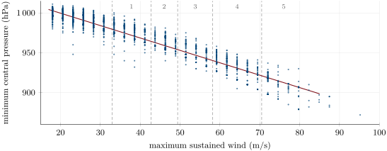
The record of the 1980–2024 storms in the archive belongs to Hurricane Patricia, off the Pacific coast of Mexico in October 2015: sustained winds of 185 knots, about , and a central pressure of .
Definition 5.8 (Storm surge)
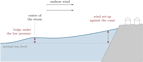
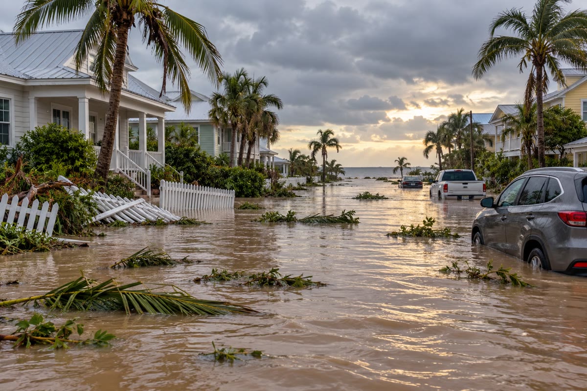
A storm surge is the rise of the sea above its normal level, tide excluded, caused by a storm: the wind piles water against the coast, and the low pressure lets the sea bulge up beneath the storm.
Proposition 5.9 (The pressure bulge)
Under a storm whose central pressure is hectopascals below that of its surroundings, the sea rises by about centimetres.
Proof. Far below the surface the pressure must be the same under the storm and outside it, otherwise the water would flow. The air above the storm weighs less by ; a column of seawater of height makes up for it if . For , with and : , about . ∎
The bulge is the smaller part of most surges: under a central pressure of , below its surroundings, it is about . The wind does the rest, pushing water towards the shore, especially over a wide, shallow sea floor. Arriving with a high tide, a surge of several metres can flood low coasts far inland.
5.5 Exercises
Exercise 5.1 ★
Define a thunderstorm and lightning. What produces the sound of thunder?
Solution
Solution of Exercise 5.1.
A thunderstorm is a storm produced by a cumulonimbus, with lightning and thunder, usually heavy showers and gusts, sometimes hail. Lightning is a giant electric spark that discharges charged regions of the storm. Thunder is the sound of the air of the lightning channel, heated so suddenly that it expands with a shock.
Exercise 5.2 ★
Define a tropical cyclone, its eye and its eyewall. Where are its winds strongest?
Solution
Solution of Exercise 5.2.
A tropical cyclone is a storm hundreds of kilometres across, formed over a warm tropical sea around a centre of low pressure, with winds spiralling in and bands of thunderstorms. The eye is its calm, nearly cloudless centre; the eyewall is the ring of towering thunderstorms around the eye. The winds are strongest in the eyewall.
Exercise 5.3 ★
In which Saffir–Simpson category is a hurricane with sustained winds of knots? Of knots? Of knots? Which of them are major hurricanes?
Solution
Solution of Exercise 5.3.
knots: category 1. knots: category 4. knots: category 5. The last two are major hurricanes (category 3 or more).
Exercise 5.4 ★
You count seconds between a flash and its thunder, then seconds for the next flash. How far away was each, and is the storm coming closer?
Solution
Solution of Exercise 5.4.
, then . The second flash is farther away: the storm is moving away.
Exercise 5.5 ★
Explain why a tree standing alone in a field is a dangerous shelter in a thunderstorm, and where you should go instead.
Solution
Solution of Exercise 5.5.
Lightning tends to strike the highest point around: a tree standing alone in a field is that point, and the current of a strike runs down it and spreads through the ground around it. Go into a building or a closed car, and stay there until well after the last thunder.
Exercise 5.6 ★★
One knot is per hour. Convert knots and knots into and into .
Solution
Solution of Exercise 5.6.
One knot is . knots: , and . knots: , about (the official table, rounded through another unit, gives ).
Exercise 5.7 ★★
There are 44 lightning flashes a second on the Earth. How many is that in a day, and in a year?
Solution
Solution of Exercise 5.7.
flashes a day, and , about 1.4 billion a year.
Exercise 5.8 ★★
A hurricane has a central pressure of in surroundings at . How high is the pressure bulge of the sea beneath it?
Solution
Solution of Exercise 5.8.
: a bulge of about .
Exercise 5.9 ★★
Using the map of tracks, describe where tropical cyclones form and where they go after forming. Why are they absent from the equator itself?
Solution
Solution of Exercise 5.9.
They form over the warm tropical oceans, mostly between and of latitude in both hemispheres, with very few in the South Atlantic. They drift west, then curve away towards the poles, where they weaken over colder water. They are absent from the equator because there the Earth’s rotation gives the inflowing air no turn: without it, the air flows straight into the low pressure and fills it, and no rotating storm can start.
Exercise 5.10 ★★
The straight line of the pressure–wind chart is ( in , in ). What central pressure does it give for the lower limit of category 5, ? For a storm of ?
Solution
Solution of Exercise 5.10.
; .
Exercise 5.11 ★★
Explain why a tropical cyclone weakens quickly when it moves over land, and why it weakens over cold water.
Solution
Solution of Exercise 5.11.
Over land the storm loses its supply of evaporating water, and with it the latent heat that drives it; the rough surface also slows the winds. Over cold water evaporation is much weaker, since cold air holds far less water vapour at saturation: the supply of latent heat dwindles.
Exercise 5.12 ★★★
The speed of sound in air is , with , in kelvin and . Compute it at and at . For a delay of , how much do the two distances differ? Is the rule “ per kilometre” good enough?
Solution
Solution of Exercise 5.12.
At : ; at , with : . For : and , a difference of about , about . The rule gives : good enough to know how close the storm is, which is all it is for.
Exercise 5.13 ★★★
A storm surge of is measured on a coast as a hurricane with a central pressure of (surroundings ) comes ashore. How much of the surge is due to the pressure bulge, and how much to the wind? If it arrives at high tide, above mean sea level, how high above mean sea level does the water reach?
Solution
Solution of Exercise 5.13.
: the bulge is about , the wind’s part , more than four times as much. At high tide the water reaches above mean sea level.
Exercise 5.14 ★★★
A tornado turns with winds of at from its axis; a hurricane with winds of in an eyewall from the centre. How long does the air take to go once round in each case? Compare.
Exercise 5.15 ★★★
Of the 3 888 tropical cyclones of 1980–2024, 24 reached tropical-storm strength within of the equator, 414 within , and 121 beyond . Compute the three percentages. The band within of the equator covers about of the Earth’s surface: what would you expect if latitude did not matter, and what do you conclude?
Solution
Solution of Exercise 5.15.
; ; . If latitude did not matter, about of the storms, some 350, would start within of the equator; only 24 do, about fifteen times fewer. Near the equator the Earth’s rotation is too weak to start the spin.
5.6 Problem: The Heat Engine of a Hurricane
Problem 5.1
Weekend problem — from a day’s rain to the power of the wind
An average hurricane rains a day over a circle of radius . Use a latent heat of , a density of water of , in a day, and the power of the winds of an average hurricane, .
Part I — A day’s rain.
- Compute the area of the circle.
- Compute the volume of rain that falls on it in a day.
- Express it in cubic kilometres.
- Compute its mass.
Part II — The heat released.
- Compute the latent heat released in a day by the condensation of this water.
- Convert it into a power.
- The whole Earth absorbs about of sunlight (Chapter 3). What fraction of it does one hurricane release?
- The average sunlight absorbed is . Compute the sunlight absorbed by the area of the storm and compare it with the storm’s latent heat.
- What does this comparison show about where the storm’s energy was gathered?
Part III — Where the water comes from.
- What mass of water must evaporate each day to feed this rain?
- The average evaporation of the Earth’s surface carries . Over what area would average evaporation supply the storm’s latent heat? Compare with the area of the storm.
- Using the table of saturation contents of Chapter 4, compare the water that saturated air holds at and at .
- Explain why tropical cyclones form only over warm seas.
- Explain why they weaken over land.
Part IV — The wind.
- Compute the kinetic energy given to the winds in a day.
- Convert the lower limit of category 3, knots, into ( knot = ).
- Air near the sea surface has a density of about . Compute the kinetic energy of one cubic metre of it moving at that speed.
- Compare the latent heat released in a day with the energy of the winds in a day.
- What becomes of the rest of the heat released?
- What fraction of the heat released by condensation becomes wind?
Solution
Solution of Problem 5.1.
1. .
2. .
3. One cubic kilometre is : about .
4. .
5. .
6. .
7. , about .
8. . The storm releases nearly twice as much heat as the sunlight absorbed by its whole area.
9. The storm does not run on the sunlight that falls on it: it releases heat stored as water vapour, evaporated from a wider area of warm sea and drawn in by the winds. The storm concentrates energy gathered over a much larger region.
10. The same mass as the rain, about a day (the vapour carried in must be renewed as fast as it rains out).
11. , about five times the area of the storm: the storm must draw vapour from a much wider area, and its winds make the sea beneath it evaporate far faster than the average.
12. at against at : , about more.
13. Warm water evaporates fast and warm air holds much more vapour: the inflowing air carries much more latent heat to release, and, saturated, it rises freely. Over cooler seas the supply is too small to drive the engine.
14. Over land there is no sea to evaporate: the supply of latent heat stops, and the rough ground slows the winds.
15. .
16. .
17. .
18. : the latent heat is some 400 times the energy given to the winds.
19. Most of it warms the upper air of the storm, which spreads out at the top and gives the heat off to space as infrared radiation; the winds themselves lose their energy to friction against the sea and the ground.
20. (the script gives a ratio of 402): about one part in 400 of the heat released by condensation becomes wind.