High School Earth and Space Sciences · Grades 10–12
15Subduction Zones
Beneath the islands of Tonga, in the south-western Pacific, the Earth shakes far deeper than anywhere else. Of the seven thousand earthquakes of magnitude 6 or more recorded worldwide between 1976 and 2025, the deepest happened down, and the section across Tonga in this chapter holds events down to about . At such depths the rock is hot and under enormous pressure; it should flow slowly, like the asthenosphere, not break. Yet it breaks. This chapter explains what is there to break: a slab of cold ocean floor, sinking back into the mantle.
You already know
At a convergent boundary two plates move toward each other; deep trenches line some of them (Book 1, grades 7 and 8). The magnitude of an earthquake measures its size, and an earthquake under the sea can raise a tsunami (Book 1, grade 7). The velocity of a plate relative to another is the difference of their velocities (Chapter 13). Ocean floor sinks as it ages, and after some 60 million years its lithosphere, about thick, is denser than the asthenosphere beneath it (Chapter 14). Seismic waves show a sharp change in the mantle at about (Chapter 11). A metamorphic rock is a rock transformed in the solid state (Book 1, grade 6).
15.1 Trenches and dipping earthquake zones
Most earthquakes are shallow: in the catalogue of magnitude 6 or more since 1976, only about one in five is deeper than , and one in fifteen deeper than . The map below shows where the deep ones are.
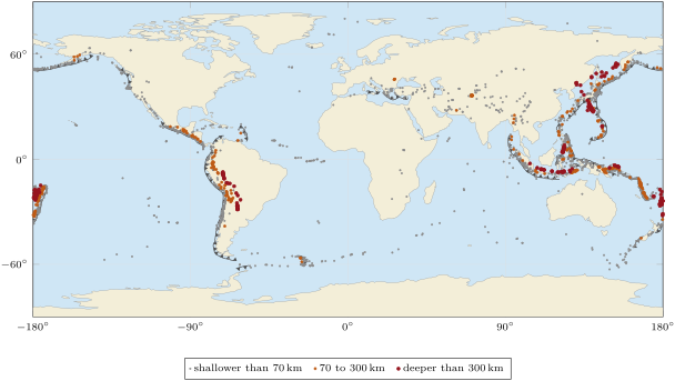
The deep earthquakes are not scattered: they follow the trenches of the western Pacific, from Kamchatka to Japan, the Marianas, Indonesia and Tonga, and the trench along the west coast of South America; and they always lie on one side of the trench, under the plate that does not sink.
Definition 15.1 (Subduction; subduction zone)
Subduction is the sinking of a plate of oceanic lithosphere beneath another plate, back into the mantle. A subduction zone is a convergent plate boundary where subduction takes place; it is marked at the surface by a trench.
Definition 15.2 (Wadati–Benioff zone)
A Wadati–Benioff zone is the inclined band of earthquakes that starts at a trench and goes deeper and deeper beneath the overriding plate, down to as much as about .
History — Wadati and Benioff
In the 1920s leading seismologists argued that earthquakes could happen only in the first few tens of kilometres: the deeper Earth, they reasoned, had no strength to store the strain. The Japanese seismologist Kiyoo Wadati, who worked with the dense network of stations of the Japan Meteorological Agency, gave from 1928 the first convincing evidence that some earthquakes are hundreds of kilometres deep: one of the events he studied, in January 1927, was down. In 1935 he published the first map of the depths of these earthquakes, drawn as contour lines, and noticed that the deepening zone ran parallel to the line of active volcanoes. In 1949 and 1954 the American seismologist Hugo Benioff showed that beneath the Andes and the Tonga–Kermadec islands the earthquakes lie along zones reaching depths of about . The zones were first called Benioff zones, in 1967; the name Wadati–Benioff zone, which gives both their due, follows a suggestion of the Japanese geophysicist Seiya Uyeda in 1971.
Method 15.3 (Reading an earthquake section)
- Choose a line perpendicular to the trench, from the trench toward the overriding plate, and keep the earthquakes within a band on either side of it.
- Plot each earthquake at its distance along the line (horizontally) and at its depth (vertically, downward).
- Look for the inclined band; draw the straight line that follows it best.
- Read the dip of the band from two points of the line (proposition below).
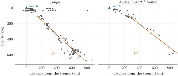
Proposition 15.4 (The dip of a slab from an earthquake section)
If two points of the line that follows a Wadati–Benioff zone lie at horizontal distances from the trench and depths and , its dip , the angle it makes with the horizontal, satisfies
Proof. The two points and the point at depth vertically above the second one form a right triangle. Its horizontal side is , its vertical side , and the angle at the first point is the dip. The tangent of an angle of a right triangle is the opposite side over the adjacent side. ∎
Example 15.5 (The dip beneath Tonga)
The line of the Tonga section passes down at from the trench and down at . So , and . Beneath the Andes, at South, the same method gives about .
The Wadati–Benioff zone traces a plate that goes down. Shallow earthquakes happen where the two plates slide against each other, near the trench; deeper ones happen inside the sinking plate itself.
15.2 Why old lithosphere sinks
Definition 15.6 (Slab)
A slab is the part of a plate that has already sunk into the mantle at a subduction zone: a sheet of oceanic lithosphere, about a hundred kilometres thick, inclined beneath the overriding plate.
What goes down is old ocean floor. From the age of the ocean floor, the floor that reaches the Japan Trench, east of Japan, is about 133 million years old, the floor that reaches the Tonga Trench about 99 million years old; even the floor that reaches the Andes, among the youngest to sink, is about 49 million years old. Such old lithosphere is cold and thick, and, apart from its light crust, denser than the asthenosphere: as soon as one edge of it starts to go down, its own weight pulls it in.
Definition 15.7 (Slab pull; ridge push)
Slab pull is the force that a sinking slab, denser than the mantle around it, exerts on the rest of its plate, pulling it toward the trench. Ridge push is the force that pushes a plate away from a ridge, where the young, hot lithosphere stands high on its raised ridge and slides down its slope.
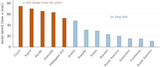
Which of the two matters more? In 1975 Donald Forsyth and Seiya Uyeda worked out the strength of each force from the speeds and the shapes of the plates: the forces on the sinking slabs control the speed of the oceanic plates, and are about ten times stronger than any other force. Today’s plate velocities show it clearly.
Proposition 15.8 (Plates attached to slabs are fast)
The five large plates from which a long slab hangs (Cocos, Nazca, Pacific, Australia, Philippine Sea) move on average at about a year; the eight without one at about a year, nearly three times slower. Each plate of the first group is faster than every plate of the second.
Proof. From the published mean speeds, the slab plates give and the others (millimetres a year); the slowest slab plate, the Philippine Sea plate at 52.6, is faster than the fastest of the others, Arabia at 47.6. ∎
15.3 The slab transformed at depth
As the slab goes down, its crust of basalt and gabbro is buried deeper and deeper while staying cold, since the slab sinks faster than heat can reach its interior. The rocks of the crust change their minerals without melting: they are metamorphosed (Chapter 21). Two rocks mark the path.
Definition 15.9 (Blueschist; eclogite)
Blueschist is a metamorphic rock made from basalt of the oceanic crust buried to high pressure while it stays relatively cold; it is coloured blue by the mineral glaucophane. Eclogite is the dense metamorphic rock that basalt and gabbro become at mantle depths along subduction zones: it has the same chemical composition, but is made of red garnet and green pyroxene.
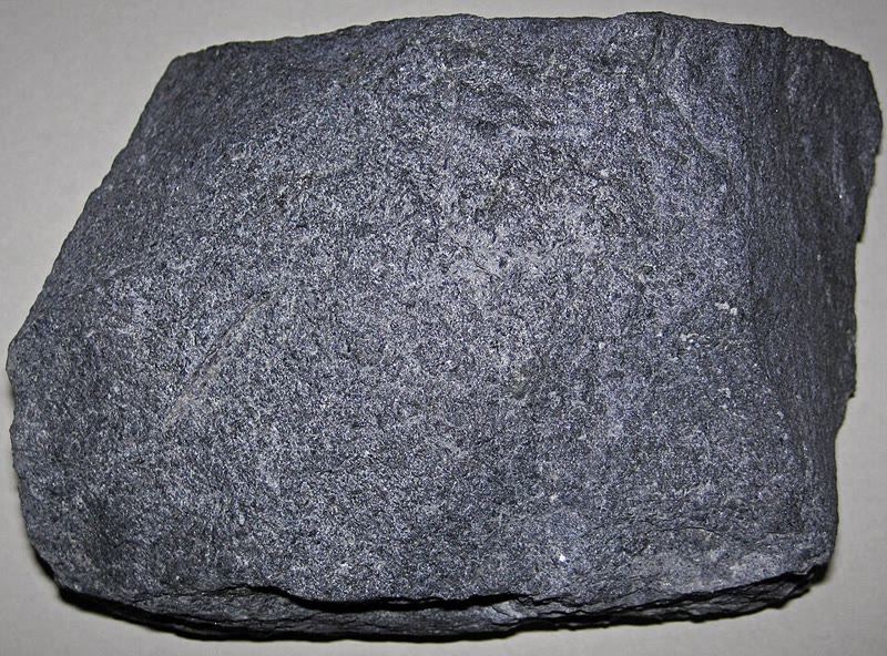
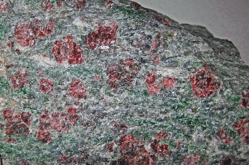
Eclogite is denser than basalt; it is even denser than the peridotite of the mantle, by about . Once its crust has turned into eclogite, the slab no longer carries a light layer on top: the whole slab is denser than the mantle around it, and pulls harder. Rocks of this kind, brought back to the surface by later movements, are among the few direct witnesses of what happens tens of kilometres down in a subduction zone.
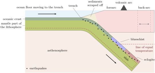
15.4 The anatomy of a subduction zone
From the ocean to the continent, or to the next ocean, a subduction zone has always the same parts.
- The trench, where the sinking plate bends down: the deepest places of the oceans.
- The forearc, between the trench and the line of volcanoes. Its edge is a pile of sediments scraped off the sinking plate; beneath it the two plates slide past each other along the plate boundary, a gently dipping fault on which great earthquakes happen, such as that of 2011 off Japan (example below).
- The volcanic arc, a line of volcanoes parallel to the trench, on islands (Tonga, the Marianas, Japan) or on a continent (the Andes); why it forms is the subject of Chapter 22.
- Behind some arcs, a back-arc, where the overriding plate is stretched; behind Tonga it is being pulled apart.
Behind Tonga the stretching of the back-arc carries the arc itself toward the Pacific plate, as satellite positioning has shown. The rate at which the two sides of the Tonga Trench converge is therefore larger than either plate’s own speed: from the PB2002 model, about a year near South.
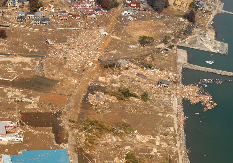
Example 15.10 (The Tōhoku earthquake, 2011)
On 11 March 2011 an earthquake of magnitude 9.1 struck off the north-east coast of Honshu, Japan. It happened about down, on the plate boundary itself, where the Pacific plate, moving west at about a year relative to the plate that carries northern Japan, sinks beneath it at the Japan Trench. The two sides of the fault slipped past each other by as much as 50 to , over an area about long and wide. The sea floor above moved with it, and raised a tsunami that ran up to high on the coast; at least people were killed and were missing. The same coast had been struck by tsunamis from this subduction zone in 1611, 1896 and 1933, and perhaps by one as large as that of 2011 in the year 869.
15.5 Exercises
Exercise 15.1 ★
Define subduction and a subduction zone. Which kind of lithosphere sinks at a subduction zone, and why that kind?
Solution
Solution of Exercise 15.1.
Subduction is the sinking of a plate of oceanic lithosphere beneath another plate, back into the mantle; a subduction zone is a convergent plate boundary where it happens, marked by a trench. Oceanic lithosphere sinks: once it is old, it is cold, thick and denser than the asthenosphere beneath it. The continental crust is too light to sink.
Exercise 15.2 ★
Using the world map of earthquakes by depth: (1) name three regions with earthquakes deeper than ; (2) on which side of a trench do the deep earthquakes lie? (3) Along the Mid-Atlantic Ridge, how deep are the earthquakes?
Solution
Solution of Exercise 15.2.
(1) For example the Tonga–Fiji region, the western Pacific from Japan to the Marianas, Indonesia, and South America. (2) Always on the side of the overriding plate, never on the ocean side. (3) Shallow: all the earthquakes of the Mid-Atlantic Ridge on the map are shallower than .
Exercise 15.3 ★
The catalogue holds earthquakes of magnitude 6 or more, of which are deeper than and deeper than . How many earthquakes is that in each case?
Solution
Solution of Exercise 15.3.
earthquakes deeper than ; deeper than .
Exercise 15.4 ★
Define blueschist and eclogite. What do both have in common with the basalt of the oceanic crust? What differs?
Solution
Solution of Exercise 15.4.
Blueschist is a metamorphic rock made from the basalt of the oceanic crust buried to high pressure while staying relatively cold, coloured blue by glaucophane; eclogite is the dense metamorphic rock that basalt and gabbro become at mantle depths, made of red garnet and green pyroxene. Both come from the oceanic crust and keep its chemical composition; what differs are the minerals, formed in the solid state under the new pressure and temperature, and the density.
Exercise 15.5 ★
List the parts of a subduction zone in order, from the ocean floor that moves toward the trench to the back-arc, saying in one line what happens in each.
Solution
Solution of Exercise 15.5.
Ocean floor: old lithosphere moving toward the trench. Trench: the plate bends down and starts to sink. Forearc: sediments scraped off the sinking plate pile up; beneath, the two plates slide past each other on the plate boundary, where great earthquakes happen. Volcanic arc: a line of volcanoes above the slab. Back-arc: behind some arcs, the overriding plate is stretched.
Exercise 15.6 ★★
On the Andes section, the line that follows the earthquakes passes down at from the trench and down at . Compute the dip of the slab.
Solution
Solution of Exercise 15.6.
, so .
Exercise 15.7 ★★
A straight slab starts at a trench and dips at . (1) How deep is it from the trench? (2) At what distance from the trench does it reach ? (3) What length of slab lies between the trench and ?
Exercise 15.8 ★★
The mean speeds of the plates are, in millimetres a year: Cocos 74.6, Nazca 70.0, Pacific 65.5, Australia 63.1, Philippine Sea 52.6 (with slabs); Arabia 47.6, Somalia 31.0, Nubia 29.2, Eurasia 22.8, North America 19.8, Antarctica 15.2, Caribbean 14.9, South America 10.6 (without). (1) Compute the mean of each group and their ratio. (2) What does this suggest about the force that drives plates?
Solution
Solution of Exercise 15.8.
(1) a year; a year; ratio . (2) Plates move fastest when a slab hangs from them: the pull of the sinking slab is the strongest force driving plates, as Forsyth and Uyeda concluded.
Exercise 15.9 ★★
In 2011 the fault off Japan slipped by as much as 50 to . The Pacific plate approaches at a year. (1) How many years of plate motion does a slip of , then , make up? (2) Compare with the time since 869, a possible earlier earthquake of the same size.
Solution
Solution of Exercise 15.9.
(1) is : years and years of plate motion. (2) From 869 to 2011 is 1142 years: of the same order. If the plate boundary stays locked between great earthquakes, the slip of 2011 released several centuries of stored motion.
Exercise 15.10 ★★
The ocean floor that reaches the Japan Trench is about 133 million years old, that reaching Tonga about 99 and that reaching the Andes about 49. (1) Using the laws of Chapter 14 ( for , beyond), find the depth of each. (2) Which is the coldest and densest lithosphere?
Solution
Solution of Exercise 15.10.
(1) Japan: ; Tonga: ; Andes: . (2) The floor reaching Japan: the oldest, so the coldest and densest lithosphere, and the deepest floor.
Exercise 15.11 ★★
The basalt of the oceanic crust has a density of about , the mantle around the slab , and eclogite is denser than the mantle. (1) Find the density of eclogite. (2) By what percentage does the density of the crust rise when it turns into eclogite? (3) Before and after, is the crust lighter or denser than the mantle, and by how much?
Solution
Solution of Exercise 15.11.
(1) . (2) : a rise of about . (3) Before, the crust is lighter than the mantle by ; after, it is denser by about . It no longer holds the slab up: it pulls it down.
Exercise 15.12 ★★★
Heat spreads by conduction over a distance of about in a time , with for rock. (1) Compute this distance for 6 million years (). (2) Compare it with the thickness of a slab, about . (3) Explain why earthquakes can happen inside a slab at while the mantle around it flows.
Exercise 15.13 ★★★
Beneath the Andes at South, the line of the section reaches at from the trench, and the plates converge at a year. (1) Estimate the length of slab from the trench to . (2) How long does a piece of ocean floor take to reach ? (3) Compare with Tonga, where the same journey takes about 6 million years.
Solution
Solution of Exercise 15.13.
(1) . (2) a year is per million years: million years. (3) About three times longer than beneath Tonga: the slab beneath the Andes sinks more slowly and at a gentler dip.
Exercise 15.14 ★★★
Take a slab thick, denser than the mantle around it by on average, and long, beneath a trench. (1) Compute the mass excess of the slab for each metre of trench. (2) Compute its weight, with . (3) Why can this force pull the whole plate?
Solution
Solution of Exercise 15.14.
(1) A slice wide along the trench has a volume of ; its excess mass is . (2) Its excess weight is for each metre of trench. (3) The slab is attached to the rest of the plate, which is rigid: the force is transmitted to the whole plate, which is dragged toward the trench, all the more since trenches run for thousands of kilometres.
Exercise 15.15 ★★★
Along the Tonga Trench the PB2002 model gives a convergence of a year at South and a year at South. (1) How far apart are the two points, along a meridian ()? (2) By how much does the rate grow per hundred kilometres? (3) The Pacific plate moves at about the same speed at both points. What must the other side of the trench, the Tonga arc, be doing?
Solution
Solution of Exercise 15.15.
(1) . (2) The rate grows by a year over , about a year per hundred kilometres. (3) The convergence is the velocity of the Pacific plate minus that of the arc. Since the Pacific plate’s velocity is about the same at both points, the arc itself must be moving toward the Pacific plate, faster and faster northward: the back-arc behind it is being stretched, more in the north than in the south.
15.6 Problem: The Tonga Slab
Problem 15.1
Weekend problem — from the trench to
Beneath the Tonga Trench the Pacific plate sinks westward. Use the Tonga section of this chapter, whose line is (both in kilometres, measured from the trench toward the arc).
Part I — The earthquake section.
- How deep is the deepest earthquake of the section?
- Why are there no deep earthquakes on the ocean side of the trench?
- Compute the depth of the line at and , then the dip of the slab.
- At what horizontal distance from the trench is the slab deep? And deep?
- The line passes above the trench at . What does this tell you about the shape of the slab near the trench?
Part II — The convergence.
- The plates converge across the trench at about a year. Convert to centimetres a year and kilometres per million years.
- The Pacific plate moves over Hawaii at about a year. How many times faster is the convergence at Tonga?
- Using the sum of relative velocities, explain how the convergence can exceed the speed of the Pacific plate.
- The floor that reaches the trench is about 99 million years old. How deep does it lie (exponential law of Chapter 14)?
- Why can such a lithosphere sink on its own?
Part III — Down to .
- At what horizontal distance from the trench does the line reach ?
- Estimate the length of the slab from the trench to that point, treating it as straight.
- How long does a piece of ocean floor take to travel this length at a year?
- How long would it take at the a year of the Pacific plate over Hawaii?
- On the way, the crust of the slab turns into eclogite, denser than the mantle at . What is its density, and what does this change for the slab?
Part IV — A cold slab in a hot mantle.
- Over the time of question 13, heat spreads by conduction over about , with . Compute this distance.
- Compare it with the thickness of the slab, about . Is the slab still cold inside when it reaches ?
- Why does this explain the earthquakes at and more beneath Tonga?
- What change in the mantle did seismic waves reveal near (Chapter 11)?
- Conclude: how long does Pacific ocean floor take to go from the Tonga Trench down to ?
Solution
Solution of Problem 15.1.
1. About .
2. On the ocean side the plate has not yet sunk: the lithosphere there is near the surface. The deep earthquakes happen inside the slab, which lies only beneath the overriding plate.
3. and ; , so .
4. and .
5. A straight line with this dip starting at the trench would pass through at ; it lies above. The slab is not straight: near the trench it dips more gently, and it steepens deeper down.
6. a year, per million years.
7. times faster.
8. The convergence across the trench is the velocity of the Pacific plate minus the velocity of the arc on the other side. If the arc moves toward the Pacific plate, as it does while the back-arc behind it is stretched, the two speeds add up, and the convergence is larger than the speed of the Pacific plate alone.
9. .
10. After about 60 million years oceanic lithosphere is denser, as a whole, than the asthenosphere beneath it; at 99 million years it is denser still. Once its edge goes down, its weight pulls the rest in.
11. .
12. .
13. million years.
14. million years.
15. : the crust, once lighter than the mantle, becomes denser than it, and the whole slab pulls harder.
16. s, and .
17. is small beside : only the outer part of the slab has warmed; its interior is still cold when it reaches .
18. The cold slab stays rigid enough to break, down to its tip, while the hot mantle around it flows: the earthquakes beneath Tonga happen inside the slab, down to about .
19. Seismic waves show a sharp change in the mantle at about : their speeds jump there.
20. About 6 million years from the trench to .