书籍暂未推出简体中文版——当前显示英文版。
University Earth and Space Sciences — Year 1 · 本科一年级
14Active Margins
On 11 March 2011, at 14:46 local time, the plate boundary off north-east Japan broke over some along the trench and down its dip. The fault slipped by as much as 50 to , most of it up-dip of the hypocentre, towards the Japan Trench; on land, the coast moved horizontally and subsided. The plate that sinks there, the Pacific plate, goes down beneath Japan along a plane that earthquakes outline down to hundreds of kilometres; and where that plane lies about a hundred kilometres deep, a line of volcanoes runs parallel to the coast. This chapter reads such a margin from its shape, its gravity, its heat flow and, above all, its earthquakes.
You already know
Oceanic lithosphere sinks back into the mantle at subduction zones, marked by trenches and by inclined zones of earthquakes, and old lithosphere sinks under its own weight (Book 2, grade 11); water from the sinking plate lowers the melting temperature of the mantle above it (Book 2, grade 12). Heat diffuses over a distance in a time of order (Chapter 10); an infinite slab of density and thickness attracts with (Chapter 11); plates move about Euler poles (Chapter 12); the heat flow of the ocean floor falls as the inverse square root of its age (Chapter 13).
14.1 The anatomy of an active margin
Definition 14.1 (Active margin, oceanic trench, forearc, back-arc basin)
An active margin is a convergent plate boundary at which oceanic lithosphere sinks beneath another plate, either beneath a continent or beneath another oceanic plate. An oceanic trench is the long, narrow, V-shaped depression of the sea floor along which the sinking plate bends down beneath the other. The forearc is the part of the overriding plate between the trench and the line of volcanoes. A back-arc basin is a basin behind the volcanoes, on the side away from the trench, where the overriding plate is stretched and new oceanic crust may form.
Trenches are the deepest places of the oceans, and the deepest of all is the Challenger Deep of the Mariana Trench. Across the Kuril Trench the floor drops from about on the abyssal plain to at the axis, some lower, and the trench is only tens of kilometres wide (figure in Section 14.2). The convergent margins of the Earth measure about in all; in a digital model of the plate boundaries the subduction boundaries add up to about , against about of spreading ridges.
Seaward of the trench the plate rises slightly before it plunges, in a broad, low outer rise. There the plate is bent, and its upper part is stretched: earthquakes of normal faulting strike the outer rises. The width of the outer rise matches the bending of an elastic plate; this flexure of the lithosphere is studied in Book 5. The trench itself is the place where the weight of the dense sinking plate pulls its leading edge down.
Definition 14.2 (Subducting slab)
The subducting slab is the part of the sinking plate that has already gone down into the mantle: a sheet of oceanic lithosphere, with its crust on top, inclined beneath the overriding plate from the trench to depths of several hundred kilometres.
The overriding plate is cut into strips parallel to the trench (figure below): the forearc, often with a pile of scraped-off sediments at its front and a sedimentary basin behind; the volcanic arc; and, behind some arcs, a back-arc basin and an older, extinct arc beyond it. Between the slab and the overriding plate lies a wedge of mantle, dragged down along the top of the slab.
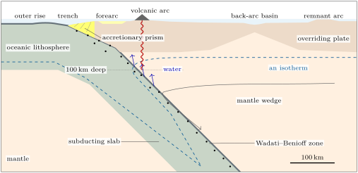
Summed over the same digital model, about of ocean floor go down the subduction boundaries each year, close to the made at the ridges (Chapter 13): within the accuracy of such a model, which leaves out the slow deformation of wide plate-boundary zones, the ocean floor is destroyed as fast as it is made, and the surface of the Earth keeps its size.
14.2 Gravity and heat flow
Felix Vening Meinesz found the long, narrow belts of negative gravity anomalies along the trenches (Chapter 11). Satellites now map them everywhere at sea. Across the Kuril Trench (figure below) the free-air anomaly rises to about over the outer rise, falls to over the trench, and is strongly positive again over the forearc and the islands of the arc.
The size of the trench anomaly tells how the trench is held. Suppose the trench, deeper than the floor around it, were not compensated at all: where the trench is, of rock of density about is replaced by sea water. By the Bouguer slab (Proposition 11.9) gravity there would be lower by
That is the size of the observed low. A trench is therefore not in isostatic equilibrium: it is a depression held down, by the strength of the bent plate and by the pull of the slab, against the buoyancy of the mantle below. (A trench only tens of kilometres wide attracts less than an infinite slab, so the water in it alone gives somewhat less than this; the rest of the deficit lies deeper, where the whole bent plate, its light crust included, is pushed down into the mantle: exercise 14.1.)
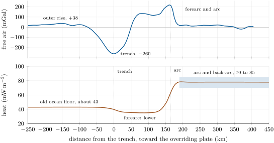
The heat flow tells the same story from the other side. The old ocean floor that comes to a trench loses little heat: about by the law of Chapter 13 for the Kuril plate, old. Over the forearc the flow is lower still: the cold slab beneath it takes up heat from above, and the mantle under the forearc is cold and stagnant. Over the arc and the back-arc it is high, 70 to on average, twice the flow of the old interiors of continents (about ). An active volcanic arc needs a mantle wedge at about some down; behind it the whole back-arc is hot, with a lithosphere only 50 to thick and its Moho at 800 to .
Why does the slab stay cold? It sinks faster than it can warm up. The Kuril slab of Section 14.3 enters at about a year and dips at : it reaches after a path of , in about ten million years. By the conductive time scale (Proposition 10.12), heat from the mantle crosses the to the middle of a slab thick in
about eight times longer. The core of the slab arrives at almost as cold as it was at the trench, and the isotherms are dragged down with it, as the section of a subduction zone above shows.
14.3 Earthquakes and the shape of the slab
Definition 14.3 (Wadati–Benioff zone)
A Wadati–Benioff zone is the inclined zone of earthquakes that starts near a trench and deepens beneath the overriding plate, down to as much as about : it outlines the subducting slab.
Its earthquakes are of two kinds. Down to some tens of kilometres they happen on the plate boundary itself, the gently dipping fault along which the two plates slide past each other; the largest earthquakes on Earth, such as that of 2011 off Japan, break this fault. Deeper, they happen inside the slab, which alone is still cold enough to store stress. At the greatest depths even the slab should flow rather than break, and how deep earthquakes start is still debated. The deepest earthquake of the catalogue, of magnitude 4.2, struck beneath the Vanuatu region in 2004 at . In every subduction zone examined, the zone is double at intermediate depths: two layers of earthquakes, further apart in older plates.
The Kuril Islands, between Hokkaido and Kamchatka, sit above a slab that earthquakes outline from the trench down to more than . There the Pacific plate, about 120 million years old where it reaches the trench, sinks beneath the Okhotsk plate (map below). The earthquakes of magnitude 5 or more since 1976 draw the slab in plan: shallow ones along the trench, intermediate ones beneath the islands, deep ones under the Sea of Okhotsk. On 24 May 2013 an earthquake of magnitude 8.3 struck beneath the Sea of Okhotsk, in the same slab farther north; it was felt as far as Moscow, some away.
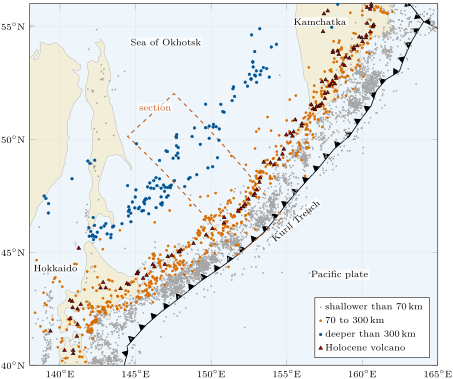
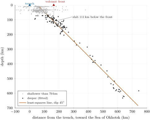
To see the slab in section, keep the earthquakes within of a line that starts at the trench and runs perpendicular to it, towards the overriding plate, and plot each at its distance along the line and its depth (figure below). The points form a band; the straight line that follows it best is found by least squares.
Method 14.4 (Fitting the slab by least squares)
Given earthquakes at inside the slab:
- compute the means and ;
- compute and ;
- the slab line is with and ; its dip is .
The line minimises the sum of the squared vertical misfits , a quadratic function of and that is smallest where both partial derivatives vanish. gives : the line passes through the centre of the points. Substituting , ; since , this is , that is .
Beneath the central Kuril Islands the band holds 599 earthquakes, 121 of them deeper than , inside the slab. The shallower ones are of little use for the fit: they mix the plate boundary and the bending plate, and 147 of the 478 are listed at the same round depth of . The 121 deeper ones give
a dip of , about , down to the deepest earthquake of the band, . The line does not pass through the trench: it reaches the surface landward of it. The slab is not straight: it leaves the trench at a gentler dip and steepens below the forearc, as the shallow earthquakes above the line show.
A cold slab is denser than the mantle around it, and its weight pulls on the plate behind it: this is the slab pull of Book 2, grade 11. Its size follows from the depth of the ocean floor.
Proposition 14.5 (The excess weight of a slab)
Under the hypotheses of the depth–age law (Theorem 13.7), a plate of age carries, per unit area, the excess mass
over the mantle at . A slab of this plate, of length along its dip and not yet warmed, has the excess weight per unit length of trench, of which acts along the slab.
Proof. A layer of the plate at the temperature has the mass per unit area, that is more than the mantle at . Summed over the plate, this excess is , which the proof of the depth–age law showed to equal both and . A slab of length has, per unit length of trench, the area and so the excess mass , whose weight is vertical; its component along a line dipping at is . ∎
The ocean floor thus weighs its own excess mass: each metre it has subsided below the ridge stands for of excess per square metre. For the Kuril plate, old, the half-space law (), which for floor this old somewhat overestimates the subsidence (Chapter 13), gives and , ten thousand tonnes on every square metre. Down to the deepest earthquake, , the slab is long, so
of it along the slab. This is an upper bound: the slab warms at its faces, and much of its weight is held by the viscous mantle it pushes aside rather than passed to the plate at the surface. Still, since the analyses of the driving forces of all the plates in the 1970s, the excess density of the sinking lithosphere is thought to provide most of the power that moves the plates.
14.4 Accretionary and erosive margins
The sinking plate brings its sediments to the trench. Some are scraped off and stay; others go down with the slab, and the slab may even take with it rock from the overriding plate.
Definition 14.6 (Accretionary prism, tectonic erosion)
An accretionary prism is a wedge of sediments, with slices of oceanic crust, scraped off the sinking plate and added to the front of the overriding plate at a trench. Tectonic erosion is the removal of rock from the overriding plate by the sinking plate, which carries it down: from the front of the overriding plate, or from the base of its crust.
A prism grows in two ways. At its front, sediments are bulldozed off the sinking plate and stacked as slices that dip away from the trench; the youngest slices are the outermost, and the older ones farther back are lifted and steepened. At its base, sediments carried down along the plate boundary are stuck to its underside, a growth called underplating. The Franciscan rocks of California are an old prism whose underplated parts are now chaotic mixtures of blocks in a sheared matrix, mélanges. A prism, like a heap of sand pushed by a bulldozer, keeps a constant taper: once the angle between its surface and its base has reached a critical value, it grows only as a larger copy of itself (exercise 14.11).
Whether a margin builds a prism or loses rock depends on the sediment that reaches the trench and on the speed of convergence. Accretionary margins, such as Cascadia, the Aleutians and the southern Peru–Chile Trench, receive plenty. Erosive margins, such as the northern Peru–Chile Trench, Tonga–Kermadec or the Marianas, receive little, and the sinking plate gnaws at their front and at the base of their crust. Erosion prevails where the plates converge faster than about a year and the sediment cover is less than thick; accretion where the convergence is slower or the trench sediment thicker than .
14.5 Volcanic arcs and back-arc basins
Definition 14.7 (Volcanic arc, arc–trench gap)
A volcanic arc is a belt of volcanoes on the overriding plate of a subduction zone, parallel to the trench and convex towards the sinking plate, fed by magma from the mantle wedge above the slab. The arc–trench gap is the horizontal distance between the trench and the volcanic front, the line of the volcanoes nearest to the trench.
Arc volcanoes stand where the top of the slab is about deep on average, though the depth beneath different arcs, averaged over stretches long, ranges from 72 to . The magma is made where water released by the slab, as its hydrous minerals break down, lowers the melting temperature of the hot mantle of the wedge (Book 2, grade 12; the magmas of arcs are studied in the Year 2 volume). Beneath the central Kurils the volcanic front lies from the trench, where the Kuril slab line is deep.
Proposition 14.8 (The arc–trench gap)
Suppose the top of the slab dips at from the trench down to the depth , then at below, and that the volcanic front stands above the place where the top of the slab is at the depth . Then the arc–trench gap is
For a slab of uniform dip , . For given , and , the gentler the dip , the wider the gap.
Proof. On the first segment the slab sinks by while it advances horizontally by , since the tangent of the dip is the depth gained per unit of horizontal distance. On the second it sinks by a further over . The front is above the end of the second run, at the sum of the two horizontal distances from the trench. With the sum is . Finally grows with on , so the second term, and , decrease as the slab steepens. ∎
A slab of with the volcanoes above it would put the front from the trench if it were straight; the Kuril front is at because the slab dips more gently beneath the forearc (exercise 14.6).
Arcs are curved, and their curvature follows from the sphere. A plate that goes down into the mantle must bend without being stretched, for a plate tens of kilometres thick cannot be stretched by tens of percent. On a sphere this fixes how a bent plate can look.
Proposition 14.9 (A bent spherical shell)
Reflect the cap of a sphere cut off by a small circle of angular radius in the plane of that circle. The reflected cap has the same shape and size as the original one, so the surface is bent without being stretched; and along the circle it is bent through the angle . A plate that sinks at the dip along such a fold can do so without stretching along a small circle of angular radius .
Proof. A reflection is an isometry: the reflected cap has the same lengths and angles as the cap, and it meets the sphere exactly along the circle, which the reflection leaves in place. Let be the centre of the sphere and the centre of the cap, on the sphere; the plane of the circle is perpendicular to . At a point of the circle the angle is ; the tangent plane of the sphere at is perpendicular to , so it makes the angle with the plane of the circle, which is perpendicular to . Crossing the circle towards , the sphere therefore rises above the plane of the circle at the angle ; the reflected cap, its mirror image, goes down below that plane at the angle . Where the unbent sphere would have gone on at above the plane, the bent surface goes on at below it: it is bent through . ∎
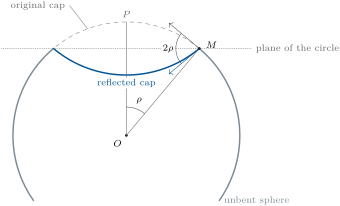
The Kuril slab dips , so the proposition predicts an arc of angular radius about . The PB2002 positions of the Kuril Trench, from Hokkaido to southern Kamchatka, are best fitted by a small circle of radius , centred near N, E, in eastern Siberia, on the side of the overriding plate. The agreement is close here, but the model is rough: the central part of the same trench alone gives . The idea is Charles Frank’s, in 1968: the Kuril–Kamchatka, Aleutian and Sumatra–Java arcs, above slabs dipping about , all have radii of about , about measured to their trenches.
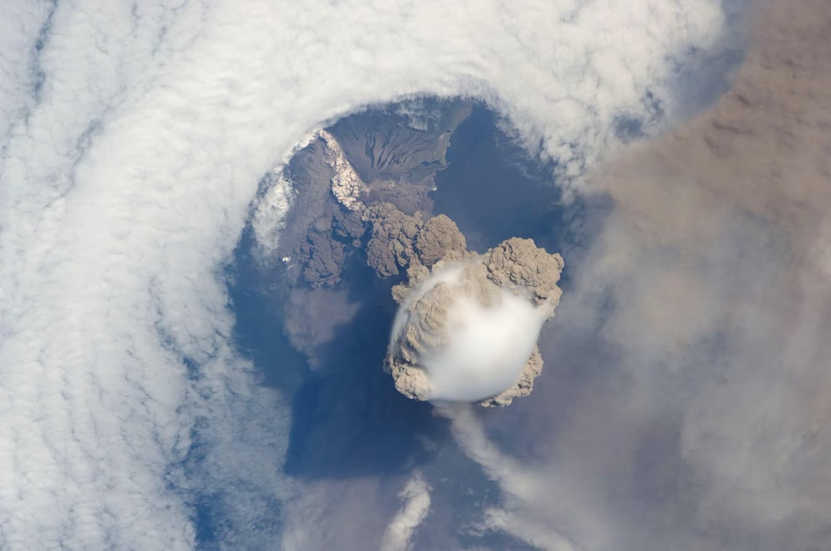
The crust beneath arcs is thickened both by shortening and by the magma added from below; beneath the arcs built on continents, such as the Andes, it is among the thickest on Earth.
Behind some arcs the overriding plate is pulled apart. Dan Karig explained these marginal basins of the western Pacific within plate tectonics, in 1971: when the slab sinks steeply and rolls back, the trench and the arc migrate towards the sinking plate, and the plate behind them is stretched until it splits, sometimes leaving an extinct remnant arc on the far side. In the plate model used above, back-arc spreading runs at about in the Mariana Trough near N, and at more than in the north of the Lau Basin, behind Tonga. Where the slab is shallow, on the contrary, it drags the overriding plate, whose crust is shortened and thickened behind the arc, as behind the Andes.
In the field — Warning of a tsunami
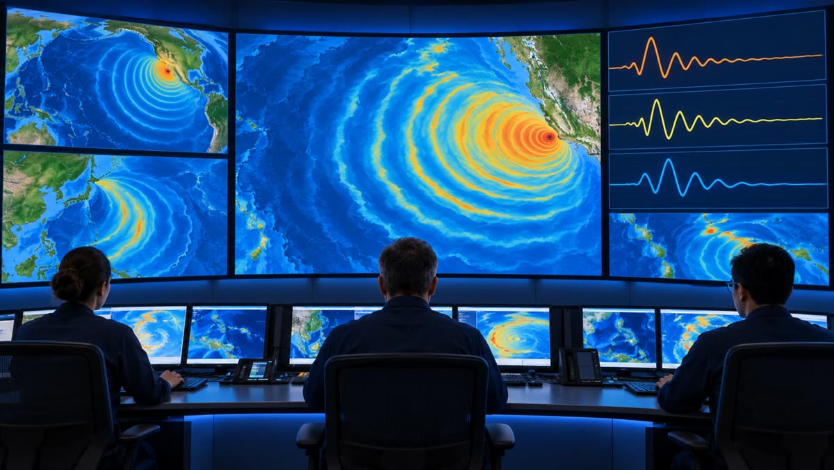
A tsunami warning centre has minutes. In 2011 the first warning for the coast of north-eastern Japan came about three minutes after the earthquake, from a magnitude based on the short-period seismic waves; for earthquakes of magnitude 8 or more such a magnitude is underestimated, and so was the height of the tsunami. The moment magnitude, which does not saturate, took about fifteen minutes: the broad-band seismometers of Japan had been driven beyond their range. Since 2013, when the size of so large an earthquake is uncertain, the first warning assumes the largest earthquake possible there and describes the tsunami in words, such as “huge”, rather than with a number, and the forecasts draw on offshore measurements of the sea itself, from buoys positioned by satellite and pressure gauges on the sea floor, which see the wave before it reaches the coast.
14.6 Exercises
Exercise 14.1 ★
A trench lies below the ocean floor around it. (a) If it were not compensated, by how much would the missing rock, of density , replaced by sea water of density , lower gravity there? Use the Bouguer slab, with . (b) Compare with the observed anomaly over the Kuril Trench, about , where the trench lies below the floor around it: redo the calculation for that depth. (c) Why does the water in a trench only tens of kilometres wide give less than the slab formula, and where must the rest of the deficit lie?
Solution
Solution of Exercise 14.1.
(a) : gravity would be lower by about . (b) For , , : the size of the observed low, so the trench is held far from isostatic equilibrium. (c) The slab formula assumes the missing rock extends without limit on every side; a trench only tens of kilometres wide removes much less mass around the point of measurement, so its water alone gives less than . The rest of the deficit lies deeper: the whole plate is bent down beneath the trench, and its crust, lighter than the mantle, takes the place of mantle at its base.
Exercise 14.2 ★
The Pacific plate enters the Kuril Trench at . (a) What length of plate goes down in 10 million years? (b) If the slab sank along a straight path dipping , how deep would its leading edge then be? (c) How long does it take to reach ?
Solution
Solution of Exercise 14.2.
(a) , so in . (b) . (c) The path to is , covered in .
Exercise 14.3 ★
Volcanoes stand above the place where a straight slab is deep. Compute the arc–trench gap for a slab dipping , and . Which arc lies farthest from its trench?
Solution
Solution of Exercise 14.3.
: for , for , for . The arc above the gently dipping slab lies farthest from its trench.
Exercise 14.4 ★
In the digital plate model of the chapter, about of ocean floor go down the subduction boundaries each year, along about , and about are made along about of spreading ridges. (a) Compute the mean convergence rate and the mean full spreading rate, in . (b) Over all its boundaries the model destroys as much area as it makes. Where does the rest of the new floor go?
Solution
Solution of Exercise 14.4.
(a) Convergence: , about . Spreading: , about . Along a shorter total length, the subduction boundaries consume ocean floor faster than the ridges make it, yet consume less in all. (b) The other or so is taken up along the other converging boundaries of the model, such as continental collisions and convergent zones within the oceans, where the plates are shortened rather than subducted; and the ridges are not the only diverging boundaries: continental rifts and some transforms also open a little.
Exercise 14.5 ★★
Four earthquakes of a section lie at , , and , in kilometres. (a) Fit the slab line by least squares and give its dip. (b) Where does the line reach the surface? (c) Compare with the dip of the line through the first and last earthquakes only.
Exercise 14.6 ★★
A model slab dips from the trench down to , then . The volcanic front stands where the slab is deep. (a) Compute the arc–trench gap. (b) Compare with a slab dipping all the way. (c) The deep segment, extended upwards, reaches the surface: where? Compare with the Kuril line, which reaches it landward of the trench. (d) What gap would a deep segment of give?
Solution
Solution of Exercise 14.6.
(a) . (b) A slab of all the way gives : the gentle shallow segment widens the gap by . (c) The deep segment is ; it reaches at , landward of the trench, as the Kuril line does at : a gentle shallow segment explains the Kuril offset. (d) .
Exercise 14.7 ★★
(a) By the bent-shell proposition, what angular radius, and what radius in kilometres (), should an arc have above a slab dipping ? ? ? (b) Which arcs are the most tightly curved? (c) The Kuril slab dips and the Kuril Trench fits a circle of : compute the relative difference from the prediction.
Solution
Solution of Exercise 14.7.
(a) The radius is half the dip, and with in radians: and for ; and for ; and for . (b) The arcs above gently dipping slabs. (c) The prediction is ; the fit, , is smaller.
Exercise 14.8 ★★
Take a conductivity of and a surface temperature of . (a) Compute the surface temperature gradient beneath a forearc losing and beneath a back-arc losing . (b) Extrapolating these gradients linearly, estimate the temperature at in each. (c) Back-arc Mohos are measured at 800 to . Why is the linear estimate too high?
Solution
Solution of Exercise 14.8.
(a) : beneath the forearc, beneath the back-arc. (b) and . (c) Part of the surface heat flow is produced by radioactivity within the crust itself, so less heat crosses the deeper levels and the gradient decreases with depth: a linear extrapolation of the surface gradient overestimates the temperature at depth.
Exercise 14.9 ★★
In the plate model of the chapter, the Mariana Trough opens near N at a full rate of about . (a) Express this rate in , and give the half-rate if the spreading is symmetric. (b) How long would the trough take to open by at this rate? (c) Give two reasons why the age of a back-arc basin cannot simply be read from its width and its present rate.
Solution
Solution of Exercise 14.9.
(a) is ; the half-rate is . (b) . (c) The rate need not have been constant; part of the width may come from the stretching and rifting of the arc before spreading began; and the axis may have jumped or spread asymmetrically.
Exercise 14.10 ★★★
A slab thick sinks at along a path dipping . Take . (a) How long does it take to reach ? (b) How far does heat diffuse into it in that time, by ? (c) How long would heat take to reach its middle? (d) Conclude about the temperature of the slab at and about its earthquakes.
Solution
Solution of Exercise 14.10.
(a) The path is , covered at in , that is . (b) , about . (c) , about . (d) Heat has reached only the outer of each side of the slab: its core arrives at almost as cold as it left the trench, colder and stronger than the mantle around it, which is why it can still break in earthquakes at that depth.
Exercise 14.11 ★★★
A model accretionary prism has a triangular section: its surface slopes at towards the trench and its base dips at beneath it, both meeting at its toe; it keeps these angles as it grows. (a) Show that its area is for a width , when the angles are small enough for the height at the back to be . (b) Sediment thick arrives on a plate converging at , and all of it is accreted: compute the width after 1, 4 and 10 million years. How does grow with time? (c) What if half the sediment goes down with the slab?
Solution
Solution of Exercise 14.11.
(a) At the distance behind the toe, the surface stands above the level of the toe and the base lies below it: the back of the prism is high, and the triangle has the area . (b) . The prism receives of section, so and : after , after , after . grows as : four times as long gives twice the width. (c) is halved and divided by : , and .
Exercise 14.12 ★★★
(a) Show that the least-squares line passes through the mean point . (b) A catalogue lists every depth too deep. How do the slope and the intercept of the fitted line change? (c) The distances are all measured from a trench point placed too far landward, so that every is too small. How do the slope and the intercept change? (d) Does either error change the dip?
Solution
Solution of Exercise 14.12.
(a) gives , that is . (b) Every and grow by , so the deviations and are unchanged: the slope is the same, and grows by . (c) The deviations are unchanged, so the slope is the same; decreases by 20, so increases by . (d) Neither: the dip depends only on the slope. Errors shared by all the points move the line without turning it.
14.7 Problem: Reading a subduction zone from its earthquakes
Problem 14.1
Weekend problem — the Kuril slab from eight earthquakes, how fast it goes down, what its gravity and heat flow say, and where its volcanoes should stand
Eight earthquakes of the Kuril slab, all deeper than , are listed by their distance from the trench along the section line, towards the Sea of Okhotsk, and their depth , both rounded to the kilometre.
| event | 1 | 2 | 3 | 4 | 5 | 6 | 7 | 8 |
| () | 155 | 222 | 305 | 319 | 431 | 533 | 578 | 609 |
| () | 96 | 169 | 245 | 272 | 389 | 489 | 518 | 573 |
| magnitude | 5.5 | 5.1 | 5.0 | 5.4 | 5.3 | 5.3 | 5.2 | 6.4 |
Part I — The slab line.
- Plot the eight earthquakes at the same scale on both axes, depth downwards.
- Compute , , , and the means and .
- Compute and , then the slope of the least-squares line to three decimals and its intercept to one decimal.
- What is the dip of the slab?
- Where does the line reach the surface? What does this say about the shape of the slab near the trench?
- Compute the misfit of each earthquake. Which lie farthest from the line, and how far?
Part II — How fast the slab goes down. At the start of the section the PB2002 model gives a convergence of : relative to the Okhotsk plate, the Pacific plate moves towards azimuth . The section line, perpendicular to the trench, runs towards azimuth .
- Compute the angle between the convergence and the section line, then the components of the convergence perpendicular and parallel to the trench.
- What length of plate goes down the trench in 10 million years?
- Using the dip of question 4 (rounded to ), how long does the slab take to carry a point of its top from the trench down to the deepest earthquake of the band, ? Neglect the gentler dip near the trench.
- The plate is about old at the trench. How old is the sea floor that is now deep?
- By , with , how far has heat diffused into the slab during that descent? Compare with its thickness, about .
Part III — Gravity and heat flow. Take a conductivity of .
- The old ocean floor in front of the trench loses about , the back-arc about ; take for the forearc. Compute the temperature gradient near the surface of each.
- Explain why the forearc loses less heat than the old ocean floor in front of it.
- The free-air anomaly over the Kuril Trench is about . What thickness of rock, denser than water, would a Bouguer slab need to give this deficit? Compare with the depth of the trench below the floor around it, about .
- Suppose now that the whole plate is pushed down by : water takes the place of rock at its top, and its crust takes the place of mantle at its base, so that, in all, mantle of density is replaced by water. Compute the Bouguer slab anomaly. Why does the real trench, only tens of kilometres wide, give less?
- The trench and the outer rise are not in isostatic equilibrium. What holds them out of it?
Part IV — Where the volcanoes should stand. Use the line of question 3, with its rounded slope and intercept.
- The first volcano of the band is from the trench. How deep is the slab beneath it?
- Is this depth within the range found beneath arcs, 72 to ? How far is it from the average, ?
- At what distance from the trench is the slab deep?
- By the bent-shell proposition, what angular radius should the Kuril arc have, and what radius in kilometres?
- The Kuril Trench fits a small circle of . Compare.
- Arc volcanoes stand, on average, where the slab is about deep. At what distance from the trench does the slab line reach that depth?
- Compare this distance with the observed : by how many kilometres and by what fraction does it differ?
- To the nearest kilometre, what arc–trench gap does the Kuril slab line predict for volcanoes standing above the slab at ?
Solution
Solution of Problem 14.1.
1. The eight points lie close to a straight line dipping about , from deep at from the trench to deep at .
2. , , , ; , .
3. and . Then and : .
4. .
5. At landward of the trench. A slab that left the trench at this dip would reach the surface there; it reaches it at the trench, so it dips more gently near the trench and steepens below.
6. The misfits are , , , , , , and . Event 7 lies above the line, event 8 below it; the others lie within about of it, a fraction of the thickness of the slab.
7. . Perpendicular to the trench: ; parallel: . The convergence is oblique.
8. is : in .
9. The path is , covered in .
10. .
11. and , about from each face: far less than the to the middle of a slab thick, whose core is still cold.
12. : beneath the old ocean floor, beneath the forearc and beneath the back-arc.
13. Under the forearc the cold slab lies only a few tens of kilometres down; it takes up heat from the rock above it, so less heat reaches the surface.
14. , about : as much as, or a little more than, the whole depth of the trench below the floor around it, about . The trench is missing mass that nothing compensates.
15. The density difference is , and , . The slab formula counts the missing mass out to any distance; the real trench is bent down only over a band tens of kilometres wide, so its deficit is smaller, about , between the two slab estimates.
16. The strength of the bending plate, which holds the trench down and the outer rise up as an elastic plate would, and the pull of the dense slab sinking into the mantle.
17. .
18. Yes: lies between 72 and , and only about deeper than the average, .
19. .
20. , and .
21. The fit, , is smaller, about : the bent shell describes the curvature of the Kuril arc well.
22. .
23. nearer the trench than the observed front, : the Kuril volcanoes stand above a slab very slightly deeper than the average, as question 18 found.
24. To the nearest kilometre, the Kuril slab line predicts an arc–trench gap of for volcanoes above the slab at (observed: ).