书籍暂未推出简体中文版——当前显示英文版。
University Earth and Space Sciences — Year 1 · 本科一年级
23Diagenesis and Sedimentary Basins
Beach sand is loose: half of it, by volume, is water between the grains. Buried three kilometres down, the same sand comes back up in a drill core as hard sandstone, its grains pressed together and the space between them much reduced and partly filled with new quartz. Between the beach and the core lie millions of years in which the sediment was buried under more sediment, squeezed, heated and soaked in water that dissolved some minerals and laid down others. This chapter follows those changes, then steps back to the places where sediment can pile up kilometres thick — the sedimentary basins — and to the two things that make room for it there: the sinking of the floor, and the rise and fall of the sea.
You already know
The porosity of a rock is the fraction of its volume made of pores, and its permeability measures how easily water flows through them (Book 1, grade 6). A region is in isostasy when every column down to the compensation depth holds the same mass (Proposition 11.4). Rifts open by normal faulting, and passive margins are the edges of continents left behind when a rift becomes an ocean (Chapter 13). The effective stress is the stress minus the pore-fluid pressure (Definition 16.6). The last glacial cycle reached its Last Glacial Maximum some twenty thousand years ago (Book 2, grade 12). Sandstones, shales and their environments are those of Chapter 21; limestones, chalk, dolomite and evaporites those of Chapter 22.
23.1 Compaction
A sediment newly laid down is a loose packing of grains with water in between. Everything that happens to it after deposition and before metamorphism, while it stays at the low temperatures and pressures of the upper few kilometres of the crust, belongs to one family of processes.
Definition 23.1 (Diagenesis)
Diagenesis is the set of physical, chemical and biological changes that a sediment undergoes after its deposition, at the temperatures and pressures of the upper crust, below those of metamorphism. It includes compaction, cementation, the dissolution of grains, and the replacement of one mineral by another; together they turn a loose sediment into a sedimentary rock.
The first of these changes is mechanical. Each new layer adds its weight to those below. The grains are pressed together, slide and rotate into a tighter packing, the soft ones (clay flakes, rock fragments, mica) bend between the hard ones, and the water between them is driven out.
Definition 23.2 (Compaction, decompaction)
Compaction is the loss of volume of a sediment under the weight of the sediments above it, by the closer packing of its grains, the expulsion of its pore water and, deeper, the dissolution of grains where they touch. Decompaction is the calculation that restores a buried layer to the thickness it had at an earlier, shallower burial, most often at the surface, when it was laid down.
Porosities measured in wells fall with depth, steeply near the surface and then more and more slowly. In 1930 L. F. Athy fitted them with an exponential, and the fit has been the starting point of compaction studies ever since.
Proposition 23.3 (Athy’s law)
In a pile of sediment of one lithology, compacted under its own weight with its pore water free to escape, the porosity at the depth below the surface is
where , the surface porosity, and , the decay length, depend on the lithology. This is Athy’s law.
Proof. Admitted at this level. ∎
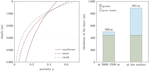
The law is an empirical fit, not a consequence of theory. Its parameters are measured, lithology by lithology, from the porosities of wells; the values of Table 23.1, published with a study of the subsidence of the North Sea, are widely used to correct for compaction. Shale starts with more water than sand but loses it over a shorter distance; chalk, the most porous of the three at the surface, loses it fastest of all. At the law gives a porosity of for sandstone, for shale and for chalk (figure below): the beach sand of the opening paragraph has lost more than half its pores.
| lithology | surface porosity | decay length (m) | grain density () |
|---|---|---|---|
| shale | 0.63 | 1960 | 2700 |
| sandstone | 0.49 | 3704 | 2650 |
| shaly sandstone | 0.56 | 2564 | 2680 |
| chalk | 0.70 | 1408 | 2710 |
Compaction squeezes out water; it neither adds grains nor takes them away, as long as nothing is dissolved and carried off or brought in as cement. The volume of the grains in a column is therefore the quantity to follow as the column is buried.
Proposition 23.4 (Solid thickness of a layer)
Under Athy’s law, a layer between the depths holds, per unit area, a volume of grains equal to the thickness
If the layer is moved to a new depth without loss or gain of grains, its new top and bottom satisfy , and for a given this equation has exactly one solution .
Proof. A slice of thickness at the depth contains the volume of grains per unit area. Integrating from to ,
With the top fixed at , the function has the derivative , since a porosity is less than one; it is continuous, zero at and grows without bound, so it takes the value exactly once. ∎
Method 23.5 (Decompacting a layer)
- Read the top and the bottom of the layer today, and its parameters and (Table 23.1).
- Compute its solid thickness with Proposition 23.4.
- Choose the depth of its top at the earlier time — zero to restore it to the surface.
Solve for the new bottom by Newton’s method: start from and repeat
until the change is below the precision wanted; two or three steps are usually enough.
- The thickness of the layer at that time is ; its mean porosity is .
Take of shale between and . It holds of grains and only of water, a mean porosity of . Brought back to the surface, the same grains make a layer thick, half of it water (figure below). The thickness of a buried shale is barely more than half of what was laid down; rates of sedimentation read from buried sections must be decompacted before they are compared with rates measured today.
Athy’s law holds only while the water can leave. Compaction is driven by the effective stress, the weight of the rock above minus the pressure of the water in the pores (Chapter 16). Where a thick shale is buried faster than its water can seep out, the water carries part of the load, the pore pressure rises above the hydrostatic, and the shale keeps a porosity too high for its depth: it is overpressured, and the correction for compaction must allow for it.
Deeper, compaction becomes chemical. Where two quartz grains press on each other through a film of water, and especially where a flake of clay or mica lies between them, quartz dissolves at the contact; the silica diffuses a short way through the water and is laid down again on clean quartz surfaces facing the open pores. The grains interpenetrate, and dissolution concentrated along surfaces leaves stylolites, jagged seams of the insoluble residue. This pressure solution, which the Year 3 volume treats as a mechanism of deformation, is both the last stage of compaction and the source of the commonest cement of sandstones.
23.2 Cementation and other changes
Compaction alone makes a dense sediment, not a hard rock. The grains are glued into a rock by minerals that grow in the pores.
Definition 23.6 (Cementation, cement)
Cementation is the precipitation of minerals from the pore water in the pores of a sediment, which binds its grains together and reduces its porosity. The minerals so precipitated form the cement of the rock; the commonest are quartz, calcite, iron oxides and clay minerals.
Groundwater carries the cementing minerals in solution, and they need not be of the same composition as the grains. Iron oxides coat the grains and colour the rocks red, brown or yellow, as in the layers of the Colorado Plateau; calcite cements sandstones and limestones alike.
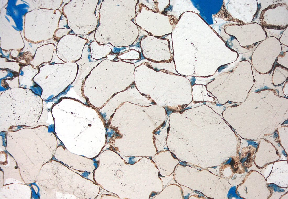
Quartz is the cement of deeply buried sandstones. It grows on the detrital quartz grains in optical continuity with them, as overgrowths: under the microscope a grain and its overgrowth go dark together between crossed polars, and the original outline of the grain shows only as a thin rim of dust or clay (figure below). In sandstones of the North Sea and of Texas studied in detail, the oxygen isotopes of the overgrowths show that the cement began to grow at and went on until the rocks reached their greatest burial temperature; the Texas sandstones hold of quartz cement, the North Sea ones only , and most of the silica came from pressure solution at the grain contacts. Because quartz grows only on clean quartz surfaces, a coat of clay on the grains leaves less surface for the cement and can preserve the porosity of a deep sandstone.
Not every change destroys porosity. Water undersaturated in a mineral dissolves it: grains of feldspar and of carbonate, and earlier carbonate cements, can be removed and leave a secondary porosity, pores shaped like the grains they replace. Clay minerals grow in the pores in turn, as coats on the grains or as crystals that fill the pores and narrow the passages between them, lowering the permeability. The minerals of the sediment change too: the aragonite of shells and of the carbonate factory reverts to calcite, which is stable at the surface, and calcite in the presence of magnesium-bearing water may become dolomite.
The replacement of calcite by dolomite, dolomitisation, is a reaction with magnesium from the water,
and it changes the volume of the solid.
Proposition 23.7 (Dolomitisation creates porosity)
If two moles of calcite of density are replaced by one mole of dolomite of density , the volume of the solid decreases by the fraction
where and are the molar masses. With and this fraction is .
Proof. The molar volume of a mineral is its molar mass divided by its density. Two moles of calcite occupy and one of dolomite ; the fraction lost is one minus their ratio. With and the two volumes are and , and . ∎
If the outer volume of the rock does not change, the solid lost is pore space gained: a limestone of porosity replaced mole for mole by dolomite has a porosity of about . The reaction needs a great deal of magnesium, which seawater holds at about a kilogram; it is favoured where brines or seawater flow through the rock for a long time (Exercise 23.12).
Diagenesis follows the history of the sediment. Just after deposition, near the surface, the pore water is still that of the sea, the lake or the rain: sediments are burrowed, cemented early on the sea floor or in the soil, and aragonite turns to calcite. With burial and heating, compaction, pressure solution and quartz cement dominate. If the basin is later uplifted and eroded, fresh water from the surface flows back into the rocks, and dissolves carbonate and feldspar again. A thin section records the order of these events: a cement that fills the pore left by a dissolved grain is younger than the dissolution, an overgrowth broken by compaction older than the compaction.
23.3 Sedimentary basins
Sediment kilometres thick accumulates only where the floor keeps sinking.
Definition 23.8 (Sedimentary basin)
A sedimentary basin is a region of the Earth’s surface where the crust has subsided for a long time, a few million to a few hundred million years, and where the space so created has been filled with sediment, hundreds of metres to many kilometres thick.
Definition 23.9 (Subsidence, tectonic subsidence)
The subsidence of a basin is the downward motion of its basement, the surface on which its sediments rest, measured relative to a fixed reference such as the centre of the Earth. Its tectonic subsidence is the part due to the processes that make the basin, as distinct from the extra sinking caused by the weight of the sediment and water that fill it; it is measured by the subsidence the basement would have had under water alone.
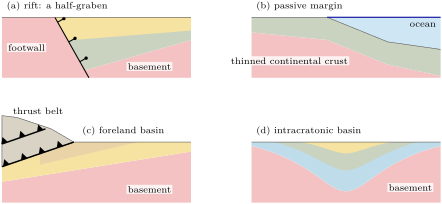
What makes the floor sink is the setting of the basin in the plate (figure below).
- Rift basins. Normal faults stretch the crust, and blocks drop between them (Chapter 13). The basins are narrow and asymmetric, half-grabens filled fastest against their border fault. The oilfields of the North Sea lie in the structures of its Viking and Central Grabens, buried under younger sediments. When the stretching stops, the thinned and heated lithosphere cools, contracts and goes on sinking, slowly, over tens of millions of years. The central North Sea, whose last major stretching ended in the mid-Cretaceous, then sank as a broad, saucer-shaped basin, filled successively by chalks, sandstones and, through most of the Tertiary, shales and mudstones; its basement, loaded by water alone, would have sunk in the middle.
- Passive margins. Where the rift became an ocean, the same cooling makes each margin sink after break-up, and a wedge of sediment thickening towards the ocean builds out over the old rift basins.
- Foreland basins. In front of a thrust belt, the weight of the stacked thrust sheets bends the lithosphere down, by isostasy, into a basin deepest against the belt and filled by the debris eroded from it. Most of the Cretaceous rocks of western Canada were laid down in such a basin in front of the Rocky Mountains.
- Intracratonic basins. In the interior of old continents, far from any plate boundary, broad round or oval regions have sunk slowly for very long times. The Paris Basin is the centre of such a structural depression, between the old massifs of Brittany, the Massif Central and the Vosges and Ardennes.
- Strike-slip basins. Where a strike-slip fault steps aside in the sense that pulls its walls apart — a releasing bend — a parallelogram of crust subsides between the two fault strands: a pull-apart basin, such as those of the Los Angeles region along the San Andreas system.
Why the lithosphere sinks in each setting, at what rate, and how the basins compare, is the subject of the Year 2 volume; here they are told apart by where they lie and by the shape of their fill.
In the field — How basins are known

Almost everything known about the deep fill of a basin comes from the search for oil, gas and water. Seismic reflection surveys image its layers and its faults over thousands of square kilometres; wells sample it at a point. A well returns the chips of rock cut by the bit, at intervals cores, and continuous logs of the physical properties of the rocks around the hole, from which the porosity is read metre by metre. The porosity–depth curves of Athy’s law, and the subsidence histories of basins, were first built from such wells.
23.4 Subsidence, accommodation and sea level
Sediment can pile up only where there is room for it below the level at which it would be moved on. In the sea that level is close to sea level, and the room is a matter of two motions: of the floor, and of the sea surface.
Definition 23.10 (Accommodation)
The accommodation at a point of a basin is the space available for sediment to accumulate there: the vertical distance from the top of the sediment to sea level, the base level of marine deposition. The accommodation created in an interval of time is the increase of the distance from a datum attached to the basement to sea level.
Definition 23.11 (Eustasy, relative sea level)
Eustasy is the change of the level of the world ocean measured relative to a fixed reference, the centre of the Earth, caused by a change in the volume of water in the ocean or in the volume of the ocean basins; it is the same everywhere. The relative sea level at a place is the height of the sea surface above a datum attached to the basement there; it changes by eustasy and by the vertical motion of the ground.
Proposition 23.12 (The accommodation budget)
In an interval of time, let be the eustatic rise of sea level and the subsidence of the basement (both positive upwards for the sea, downwards for the floor). The accommodation created is
and it is shared between the thickness of sediment added above the datum, , and the deepening of the water, : .
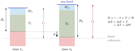
Proof. Measure heights from the fixed reference. Let be the height of the sea surface, that of the datum, the thickness of sediment above the datum, and the depth of water above the sediment, so that . The relative sea level is . Over the interval, and , so ; and . ∎
A sea floor kept at a constant depth () is filled exactly as fast as accommodation is created; one that shallows is filled faster, and the shoreline moves out to sea; one that deepens is starved. is the change of thickness of the whole pile above the datum: it counts the new sediment laid down, minus the thinning of the older sediments below as they compact, so compaction itself makes room for more sediment (figure below).
A basin does not sink by its tectonic subsidence alone: the sediment that fills it is a load, and the lithosphere sinks further under it.
Proposition 23.13 (Sediment loading amplifies subsidence)
In local (Airy) isostasy over a mantle of density , a basin whose basement, loaded by water of density alone, would lie at the depth below sea level holds, when filled to sea level with sediment of mean density , the thickness
of sediment. On land, filled to the level of the surroundings with air above, the factor is .
Proof. Compare the two columns with the same lithosphere, of mass per unit area and thickness , down to a compensation depth below both. The water-loaded column holds ; the sediment-filled one . By Proposition 11.4 the two masses are equal, so , that is . With air in place of water, is replaced by zero. ∎
With , and sediment of mean density , the factor is : a basin whose tectonic subsidence would make room for of water holds of sediment. On land the factor would be . The density of the fill is not constant: it grows as the sediment compacts, and the factor with it, so that turning a sediment thickness into a tectonic subsidence requires the decompaction of each layer, time step by time step. That procedure, backstripping, belongs to the Year 2 volume.
Sea level itself is far from fixed. At the Last Glacial Maximum, ice sheets covered much of North America and northern Europe, and the water locked in them had been taken from the ocean. Corrected for the response of the solid Earth to the changing loads of ice and water, the observations of former shorelines give a sea level that fell quickly by about some years ago and then slowly, to below today’s, from ; the grounded ice then held about more than today. The figure of often quoted is smaller because it is usually not corrected for these isostatic effects. Deglaciation came mainly between about and , at an average of per thousand years, and at a year or more between and .
Older lowstands are read from the oxygen isotopes of foraminifera in deep-sea cores, which record the volume of ice on land. Stacking seven such reconstructions over the last years, and five over the last , averages out the errors of each; scaled to the Holocene and to the last glacial lowstand, the stack carries an uncertainty of (figure below). It shows the glacial cycles as a saw-tooth: slow falls of sea level, each ended by a fast rise — five times in the last years a rise of more than in less than years. Eustasy on this scale moves the shoreline back and forth across the continental shelves.
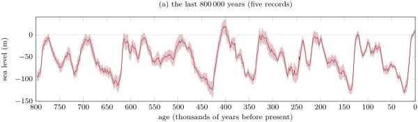
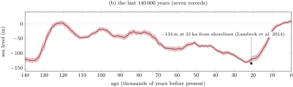
Over the life of a basin such swings are brief. A glacial fall of more than in a few tens of thousands of years is fast and large compared with tectonic subsidence, which adds up to a kilometre or more only over tens of millions of years; but the glacial swings stay within a range of about , so that in the thick fill of a basin subsidence makes most of the room, and eustasy sets the rhythm of its layers.
23.5 Exercises
Exercise 23.1 ★
With the parameters of Table 23.1, compute the porosity of sandstone and of shale at . At what depth has the porosity of each fallen to half its surface value?
Solution
Solution of Exercise 23.1.
Sandstone ; shale . The porosity halves when , at : for sandstone, for shale.
Exercise 23.2 ★
During an interval of time, sea level rises by by eustasy, the basement of a shelf subsides by , and of sediment are added above a datum on the basement. With Proposition 23.12, compute the accommodation created and the change of water depth. Does the shelf deepen or shallow?
Solution
Solution of Exercise 23.2.
. Of it, is filled with sediment, so : the shelf deepens by .
Exercise 23.3 ★
A basin’s tectonic subsidence would make room for of water. With and , how thick is the sediment that fills it to sea level if its mean density is ? ? Why does a denser fill give a thicker one?
Exercise 23.4 ★
Calcite has the molar mass and the density ; dolomite and . (a) Compute the molar volume of each. (b) By what fraction does the volume of the solid change when two moles of calcite become one mole of dolomite? (c) A limestone of porosity is dolomitised mole for mole without change of its outer volume. What is its new porosity?
Solution
Solution of Exercise 23.4.
(a) Calcite ; dolomite . (b) Two moles of calcite occupy , one of dolomite : the solid shrinks by . (c) In a cubic metre, the of calcite becomes of dolomite; the porosity becomes .
Exercise 23.5 ★★
A shale occupies the top of a basin. (a) Compute its solid thickness and its mean porosity. (b) It is buried until its top lies at . Using Method 23.5 with the top moved down instead of up, find its new thickness and its mean porosity. (c) How much water has each square metre of the shale expelled?
Solution
Solution of Exercise 23.5.
(a) ; the mean porosity is . (b) With the top at , solving gives : the layer is thick, of mean porosity . (c) The grains are the same, so the water lost is the thickness lost: of water per square metre.
Exercise 23.6 ★★
A sandstone lies between and . (a) Compute its solid thickness. (b) Decompact it to the surface with Method 23.5, writing down each Newton step from . (c) By what factor has burial thinned it?
Solution
Solution of Exercise 23.6.
(a) . (b) From : , , ; then , , ; a third step changes it by less than a millimetre. The sandstone was thick at the surface. (c) : burial has thinned it by a factor of .
Exercise 23.7 ★★
At the Last Glacial Maximum the grounded ice held about more than today. Take the density of ice , that of meltwater , and the area of today’s ocean . (a) What fall of sea level does this ice represent? (b) Compare with the found from former shorelines. (c) What ocean area would give exactly , and why was the glacial ocean smaller?
Solution
Solution of Exercise 23.7.
(a) The ice holds of water; spread over it is of sea level. (b) The shorelines give , more. (c) , less than today. As sea level fell the continental shelves emerged, so the glacial ocean was smaller, and the same volume of water taken from it lowered it more.
Exercise 23.8 ★★
The sea-level stack gives at and at . (a) Compute the mean rate of rise, in metres per thousand years, and compare it with the per thousand years found from former shorelines for the main deglaciation. (b) Between and sea level rose at a year or more. How many times the average is that, and how much did sea level rise in those five hundred years?
Solution
Solution of Exercise 23.8.
(a) per thousand years, close to the found from shorelines. (b) a year is per thousand years, times the average; in five hundred years, .
Exercise 23.9 ★★
A shelf lies under of water. Its basement subsides at per million years. (a) Over two million years sea level falls by by eustasy while the water depth stays the same. How much accommodation is created, and how much sediment is added? (b) Sea level then falls by in years, at the onset of a glaciation, and no sediment is added. How high above sea level does the former sea floor stand at the end?
Solution
Solution of Exercise 23.9.
(a) and : , all filled with sediment since the depth is unchanged. (b) In years the basement subsides only : the relative sea level falls by . The sea floor, which lay below sea level, ends above it: the whole shelf emerges.
Exercise 23.10 ★★★
(a) Show that a layer of thickness at the depth , thin compared with the decay length , has the thickness when restored to the surface. (b) Apply it to of shale at , and compare with the exact decompaction, . (c) Why is the approximation slightly too large?
Solution
Solution of Exercise 23.10.
(a) For a thin layer the porosity is nearly constant across it: its solid thickness is at depth and at the surface. Equating the two gives . (b) , so , against exactly. (c) Restored to the surface, the layer is thick, no longer thin compared with the decay of porosity near the surface: its porosity falls from at its top to less at its base, so its grains fit in a little less than the thickness computed with throughout.
Exercise 23.11 ★★★
A basin is filled to sea level by of shale, compacted by Athy’s law, its pores full of water of density . (a) Compute the mean porosity and the mean density of the fill. (b) With Proposition 23.13 and , compute the loading factor and the water-loaded subsidence that the fill represents. (c) Why would taking the density of the grains, , give a much larger factor, and why would that be wrong?
Solution
Solution of Exercise 23.11.
(a) ; the mean porosity is and the mean density . (b) The factor is ; the fill represents a water-loaded subsidence of . (c) With the grain density the factor would be and the subsidence only . It would be wrong because a third of the fill is water: the sediment is far lighter than its grains, and only the density of the saturated sediment counts in the balance of masses.
Exercise 23.12 ★★★
A cubic metre of limestone of porosity is to be dolomitised completely, mole for mole. Seawater holds of salt per kilogram, of which the mass fraction is magnesium (). (a) How many moles of calcite does the cube hold (molar volume from Exercise 23.4)? (b) How many moles of magnesium does the reaction need? (c) What mass and what volume of seawater () must flow through the cube if it gives up all its magnesium? (d) What does the answer say about where dolomite forms?
Solution
Solution of Exercise 23.12.
(a) The cube holds of calcite, that is moles. (b) One magnesium per two calcite: moles. (c) A kilogram of seawater holds of magnesium, ; the reaction needs of seawater, — more than two hundred times the volume of the rock, even if every ion of magnesium is taken. (d) Dolomite can form on a large scale only where very large volumes of water flow through the rock for a long time, or where the water is a brine richer in magnesium than seawater: in platforms flushed by sinking brines, for instance, rather than in a sediment that keeps the same pore water.
23.6 Problem: Decompacting a basin’s fill
Problem 23.1
Weekend problem — how thick the sediments of a well were when they were laid down, and how the room for them was made
A well drilled on a coastal plain, at sea level, passes through three units before it reaches the basement at :
| unit | lithology | depth today (m) | time of deposition |
|---|---|---|---|
| 1 | sandstone | 0–800 | |
| 2 | shale | 800–2600 | |
| 3 | chalk | 2600–3200 |
Take the parameters of Table 23.1, pore water of density , , and assume that each unit compacted by Athy’s law, with its water free to escape, throughout its history. Microfossils show that the water was shallow, and of the same depth, at the start and at the end of each interval.
Part I — The column today.
- Compute the porosity at the top and at the base of each unit.
- Compute the mean porosity of each unit.
- How much water does each unit hold under one square metre?
- Compute the bulk density of each unit, saturated with water, and the mean density of the whole column.
- Compute the lithostatic and the hydrostatic pressures at the base of the column, and the effective stress there.
- At what depth are the porosities of sandstone and shale equal? Which is the more porous below it?
Part II — The grains.
- Compute the solid thickness of each unit.
- What is the solid thickness of the whole column, and what fraction of today’s column is water?
- Compute, for each unit, the rate of accumulation of grains, in metres of solid per million years.
- Which unit had the fastest supply of grains? The slowest?
Part III — The units as they were laid down.
- How thick was the sandstone when it was laid down? Why is no calculation needed?
- Decompact the shale to the surface: how thick was it at , when its deposition had just ended?
- Decompact the chalk to the surface: how thick was it at ?
- How thick was the chalk at , buried under the shale of the previous question?
- What was the thickness of the whole column above the basement at and at ?
- Compute the rate of sedimentation of each unit from its thickness today, and from its thickness at deposition. Which is the meaningful one?
- By what fraction has the shale thinned since ?
Part IV — Making room.
- Take the top of the basement as datum. With Proposition 23.12, compute the accommodation created from , from and from to today.
- An eustatic curve for the region gives sea level higher at than at , and higher at than today (assumed values). Compute the subsidence of the basement in the last two intervals.
- Compute the mean rate of subsidence in each, in metres per million years.
- What share of the subsidence did eustasy have to make up in each interval? Did eustasy help or hinder the basin’s filling?
- Of the accommodation filled since , how much was made by the compaction of the shale and the chalk below?
- Why can the subsidence of the basement not be read from the thickness of the column today?
- What was the thickness of the shale unit when it was laid down?
Solution
Solution of Problem 23.1.
1. Sandstone: , . Shale: , . Chalk: , .
2. With from Proposition 23.4 and (question 7): sandstone , shale , chalk .
3. : sandstone , shale , chalk of water per square metre.
4. : sandstone , shale , chalk . The column weighs per square metre: a mean density of .
5. Lithostatic ; hydrostatic ; effective stress .
6. gives . Below it the sandstone is the more porous: shale starts wetter but loses its water over a shorter distance.
7. Sandstone ; shale ; chalk .
8. of grains; water makes of the column.
9. Sandstone , shale , chalk of solid per million years.
10. The shale had the fastest supply, the chalk the slowest — but the three differ by only about a fifth, far less than their thicknesses today suggest.
11. : its top is at the surface today, where its deposition has just ended, so its thickness at deposition is its thickness today.
12. Solving for the shale by Method 23.5 gives : the shale was thick at .
13. for the chalk gives at .
14. With its top at , gives : the chalk was thick.
15. at ; at .
16. From today’s thicknesses: sandstone , shale , chalk per million years. From the thicknesses at deposition: , and . The second set is the meaningful one — the rate at which the sea floor was built up — and it shows a steady rate that today’s thicknesses hide.
17. .
18. The water depth is the same at the start and the end of each interval, so the accommodation created is the growth of the column above the datum: from 75 to , from 55 to , and since .
19. : from 55 to ; since.
20. and per million years.
21. and . Sea level fell in both intervals, so eustasy hindered the filling: the basement had to subside that much more to make the same room. Subsidence made essentially all of the accommodation.
22. The shale and the chalk were thick at and are today: their compaction made of room, of the filled by the sandstone.
23. Each unit has been thinned by the burial that followed it, by an amount that depends on its lithology and on how deep it went; the room made in each interval must be measured with the thicknesses the units had then, which only decompaction gives. And even then the subsidence so found includes the sinking caused by the weight of the sediment, which must be removed to reach the tectonic subsidence.
24. , about — more than the the well finds today.