University Earth and Space Sciences — Year 1 · स्नातक वर्ष 1
4Geological Maps
A geologist crosses a range of low hills with a map board, a notebook and a compass-clinometer. Most of the ground is grass, wood or ploughed field; rock shows only here and there, in a stream bank, a road cutting, a crag. From these scattered glimpses, and from the shape of the land, the geologist must say which rock lies under every square metre of the hills, how the layers are tilted, where they are broken, and in what order all this happened. The result is a geological map: a flat drawing that encodes a three-dimensional body of rock. This chapter explains how such a map is made and how it is read — how the attitude of a surface is measured and computed, why the outcrop of a layer draws the patterns it does, and how a map tells a history. Its examples come from an imaginary but geologically consistent region, the Varden Hills, which recurs throughout this book.
You already know
A topographic map shows the relief with contour lines, lines of equal elevation; its scale relates distances on the map to distances on the ground (Book 1, grade 9). Relative ages follow from superposition (a layer is younger than the layers below it, unless the sequence has been overturned), from cross-cutting (whatever cuts a rock is younger than it) and from inclusion (Book 1, grade 7). A fault is a fracture along which the two blocks have moved (Book 1, grade 7); the geometry of folds and faults is the subject of Chapter 17.
4.1 A map is a cut through three dimensions
Definition 4.1 (Geological map)
A geological map shows, at every point of the ground surface, the rock unit that lies there beneath the soil, with the contacts — the surfaces separating two units — and the structures (faults, fold axes, attitudes of layers) that affect them. A map unit is a body of rock that can be recognised and followed in the field and is drawn in one colour; its outcrop is the area where it lies at the surface.
Definition 4.2 (Digital elevation model)
A digital elevation model is a grid of ground elevations, , at regularly spaced points. A geographic information system stores such grids and the map’s other layers (contacts, faults, measurements, boreholes) in a common frame of coordinates and computes with them.
Proposition 4.3 (The outcrop of a contact)
Let the ground be the surface and a contact the surface . The trace of the contact on the map is the curve
the projection on the horizontal plane of the intersection of the two surfaces. The unit lying above the contact crops out where .
Proof. A point of the map lies on the trace if and only if the ground surface at that point belongs to the contact, that is . Where , the ground is above the contact: the rock at the surface belongs to the unit lying above it. ∎
Remark 4.4 (How the maps of this book are drawn)
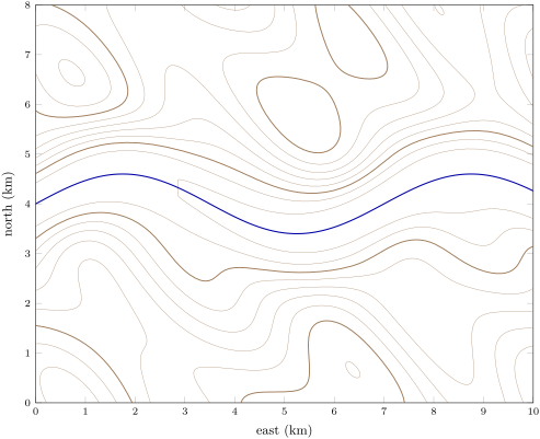
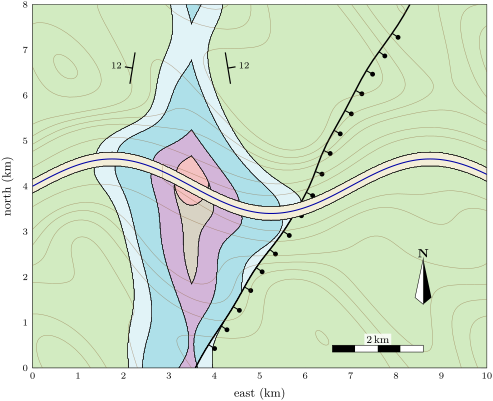
This is exactly how a geographic information system draws a map from a three-dimensional model: it evaluates on the grid of a digital elevation model and traces the curves where it changes sign. The maps of the Varden Hills in this book were drawn that way, from a geological model in which every surface is known.

4.2 The attitude of a plane
Definition 4.5 (Strike, dip and dip direction)
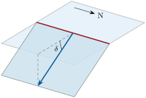
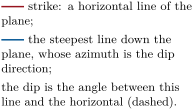
Let a geological surface — a bedding plane, a contact, a fault — be locally a plane. Its strike is the direction of the horizontal lines it contains, given as an azimuth (degrees clockwise from north). Its dip is the angle between the plane and the horizontal, measured in the vertical plane perpendicular to the strike, . Its dip direction is the azimuth of the steepest downward line of the plane. Together they form the plane’s attitude, written dip direction/dip, for instance .
Notation 4.6 (Strike by the right-hand rule)
A strike can be read in two opposite directions. The right-hand rule chooses the one for which the plane dips to the right of an observer looking along the strike: strike (modulo ). On a map, the symbol is a strike line with a short tick pointing down the dip, labelled with the dip.
Proposition 4.7 (The equation of a dipping plane)
With to the east, to the north and upward, the plane of dip direction and dip through the point is
Proof. The horizontal unit vector pointing in the dip direction is (an azimuth is measured from north, the axis, toward east, the axis). Along the strike, perpendicular to , the plane is horizontal; along it descends by per unit of horizontal distance. The horizontal distance of a point from the strike line through , counted positive down-dip, is , whence the formula. ∎
Theorem 4.8 (Attitude from three points)
Let be three non-collinear points of a plane, and , chosen with (replace by otherwise). Then the dip and the dip direction of the plane are
that is the angle with and (the plane is horizontal if ).
Proof. is perpendicular to two independent vectors of the plane, hence normal to it. The dip is the angle between the plane and the horizontal, equal to the angle between their normals, and the vertical : . By Proposition 4.7, the plane is , that is ; its upward normal is proportional to , whose horizontal part points in the dip direction . Since is a positive multiple of this normal, points in the dip direction too. ∎
Method 4.9 (The three-point problem)
To find the attitude of a contact met in three boreholes (or seen at three outcrops):
- for each borehole, take the elevation of the contact: the ground elevation minus the depth at which the contact was met;
- write the three points in metres, east, north;
- compute and make positive;
- apply Theorem 4.8; give the attitude as dip direction/dip and, if asked, the strike by the right-hand rule.
On paper, the same problem is solved with structure contours: on the line joining the highest and the lowest point, find by proportion the point at the elevation of the third one; the line through these two points of equal elevation is a strike line; the dip follows from the elevation difference between two parallel strike lines and their spacing.
Example 4.10 (The east limb of the Varden anticline)
Three boreholes, E1 at , E2 at and E3 at (metres east and north of the map’s south-west corner), meet the base of the limestone at elevations , and . Then , ; their cross product is , which points downward, so
Hence , , and the dip direction is the azimuth of , : the attitude is , strike by the right-hand rule. The base of the limestone dips gently east-north-east.
4.3 Outcrop patterns
Proposition 4.11 (Horizontal and vertical contacts)
The trace of a horizontal contact follows the contour line of its elevation. The trace of a vertical contact is a straight line on the map, whatever the relief.
Proof. For , the trace is the contour (Proposition 4.3). A vertical plane is the set of points whose horizontal position lies on one straight line, at any elevation; its trace on the map is that line. ∎
Theorem 4.12 (The V-rule)
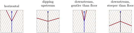
A planar contact crosses a valley whose floor descends downstream with gradient . Let be the tangent of the contact’s apparent dip in the downstream direction ( if it dips downstream, if it dips upstream, if horizontal). Then the outcrop trace makes a V whose apex lies on the valley floor and
- points downstream if : the contact dips downstream more steeply than the valley floor descends;
- points upstream if : the contact is horizontal, dips upstream, or dips downstream less steeply than the floor.
A vertical contact makes no V.
Proof. Let be the distance measured downstream along the valley floor. The floor is at elevation ; in the vertical section along the valley, the contact is at . On the floor the trace is where :
On a valley side, at a point higher than the floor by and at the same distance from the valley’s source, the ground is at , so the trace is where :
If , the trace lies farther downstream on the floor than on the sides: the V points downstream. If , the reverse. A vertical contact crosses the floor and the sides at the same . ∎
Remark 4.13 (The width of an outcrop)
The width of a unit’s outcrop depends on its thickness, on its dip and on the slope of the ground: a thin layer dipping in the same direction as the slope can crop out over a wide area. Thickness is computed from a map and a cross-section in Chapter 5.
4.4 Folds, faults, intrusions and unconformities on a map
Definition 4.14 (Anticline and syncline)
A fold is a bend of once-planar layers. An anticline is a fold whose layers are convex upward (an upfold); a syncline is a fold whose layers are concave upward (a downfold). The two sides of a fold are its limbs; its fold axis is the line along which the layers bend most, and the axis plunges when it is not horizontal. A line such as a fold axis is located by its trend, the azimuth of its horizontal projection taken in the downward direction, and its plunge, the angle it makes with the horizontal (Chapter 6). Fold geometry in three dimensions is the subject of Chapter 17.
Proposition 4.15 (Fold patterns)
On a map of eroded folded layers, an anticline shows the oldest units in its core and younger units outward on both sides; a syncline shows the youngest in its core. If the fold axis plunges, the outcrops close around the fold: the closure of an anticline points in the direction of plunge, that of a syncline the opposite way.
Partial proof. In an anticline the layers rise toward the axis, so a roughly level erosion surface cuts deepest into the sequence there and exposes its oldest, lowest units; in a syncline the youngest units are preserved lowest, in the core. If the axis plunges, consider a contact of an anticline: it is an arch whose crest descends along the plunge. Where the crest is above the ground, the ground cuts the arch along two limbs; where the crest passes below the ground, the contact no longer reaches the surface. The two limbs of the trace therefore join round the point where the crest meets the ground, and that closure lies in the direction of plunge. A syncline is a trough whose bottom rises the opposite way, so its closure points against the plunge. The argument assumes gentle relief compared with the drop of the axis. ∎
Proposition 4.16 (Faults, intrusions and unconformities)
On a map:
- a fault interrupts and offsets the contacts it crosses; on the block that moved down, younger units come to the surface opposite older ones; the trace of a dipping fault obeys the V-rule like any plane;
- a pluton or a dyke cuts across the contacts of the rocks it intrudes, and is younger than them;
- at an unconformity, the contacts of the older rocks are cut off along the base of the younger ones, which may rest on several older units in turn.
Method 4.17 (Reading the history from a map)
- List the units in order of age, from the legend and from superposition.
- Find what cuts what: faults, intrusions, unconformities; each is younger than everything it cuts and older than everything that seals it.
- Find the folds and their axes; a fold is younger than the youngest unit it folds.
- Write the events in order, each with the evidence on the map.
Example 4.18 (The history of the Varden Hills)
On the map of the Varden Hills: the schist is the oldest unit; the granite cuts it, so it is younger; the sandstone rests on both, cutting off the granite’s outline: an unconformity, after a long erosion. The sandstone, limestone, shale and chalk follow one another without a break and are folded together into an anticline (sandstone and basement in the core, near ) and a syncline (chalk in the core, east of the map’s centre): the folding came after the chalk was laid down. The fault offsets the folded contacts: it is younger than the folding. Finally the river has cut down and spread its alluvium, which no fault breaks.
In the field — Measuring an attitude
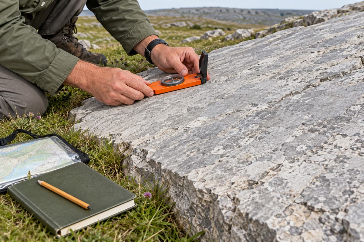
On a clean bedding surface, the geologist lays the edge of a compass-clinometer horizontal and reads the strike on the compass, then sets it down the steepest slope and reads the dip on the clinometer. Every measurement is written in the notebook with its position and plotted on the map at once, so that an inconsistent reading shows up while the outcrop is still at hand. Today, positions come from satellite receivers, measurements are entered on tablets that run a geographic information system, and outcrops are photographed and placed on digital elevation models.
History — The first geological map of a country
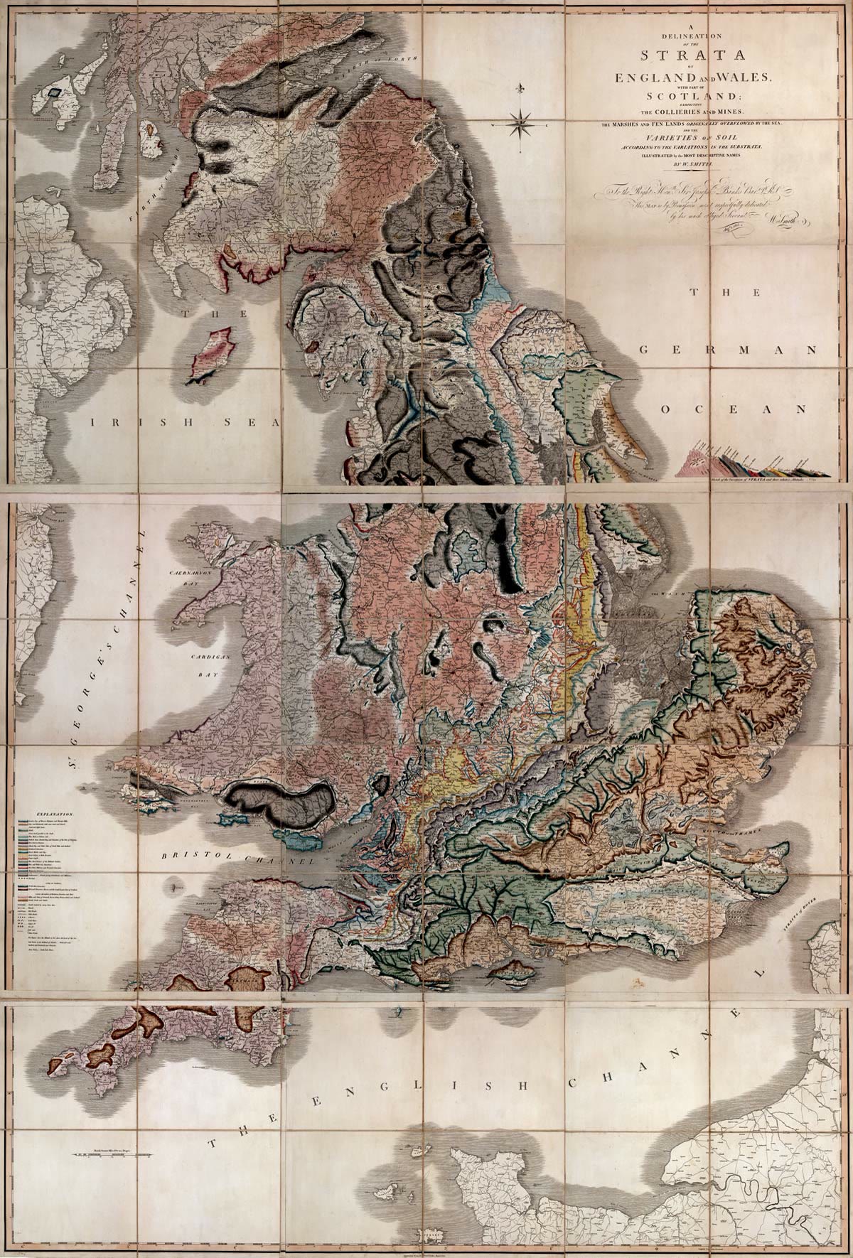
The surveyor William Smith, who dug canals and drained land in England, noticed that each layer of rock carried its own fossils, in an order that was the same everywhere. Using the fossils to recognise the layers, he followed them across the country for more than fifteen years. His map, A Delineation of the Strata of England and Wales, with part of Scotland, dated 1 August 1815, is considered the first geological map of a complete country.
4.5 Exercises
Exercise 4.1 ★
Define the strike, the dip and the dip direction of a plane. A bed has attitude : give its strike by the right-hand rule and draw its map symbol.
Solution
Solution of Exercise 4.1.
Strike: azimuth of the horizontal lines of the plane; dip: angle between the plane and the horizontal, measured perpendicular to the strike; dip direction: azimuth of the steepest downward line. For , the strike by the right-hand rule is . Symbol: a strike line oriented N 45 E, with a tick on its south-east side (toward ) labelled 40.
Exercise 4.2 ★
Write the equation of the plane of attitude through the point , coordinates in metres. At what elevation is it at and at ?
Solution
Solution of Exercise 4.2.
. At : . At : , the plane being horizontal along its north–south strike.
Exercise 4.3 ★
On a map, the trace of a contact follows the contour line exactly, over several kilometres of hills and valleys. What can you say about the contact? And if its trace is a straight line across hills and valleys?
Solution
Solution of Exercise 4.3.
A trace that follows a contour is a horizontal contact, at . A trace that runs straight across hills and valleys belongs to a vertical contact.
Exercise 4.4 ★
On the map of the Varden Hills, which unit crops out in the core of the anticline along the river, and which unit occupies the core of the syncline? Explain why with the principle of superposition.
Solution
Solution of Exercise 4.4.
Along the river, the core of the anticline shows the schist and the granite (beneath the sandstone); the core of the syncline is occupied by the chalk. The oldest units lie lowest in the sequence: where the layers arch upward and erosion cuts deepest into them, the oldest appear; where they sag, the youngest are preserved in the middle.
Exercise 4.5 ★★
A contact is met at elevations at , at and at (metres, east, north). Find its strike, dip direction and dip, first by reasoning on structure contours, then with Theorem 4.8.
Solution
Solution of Exercise 4.5.
The first two points are at the same elevation: the line is a strike line, so the strike is east–west. The contact is lower to the north: it dips north, , ; dip direction , strike by the right-hand rule. With the theorem: , , , , , and points north: the same result.
Exercise 4.6 ★★
A valley floor descends northward at per km. Which way does the V of the outcrop of a contact point if the contact (a) is horizontal; (b) dips south; (c) dips north; (d) dips north? Justify with Theorem 4.12.
Solution
Solution of Exercise 4.6.
Downstream is north, (). (a) : V upstream (south), along the contours. (b) : V upstream. (c) : V upstream. (d) : V downstream (north).
Exercise 4.7 ★★
In the situation of the V-rule, a contact dips downstream with () and the valley floor descends with . A point on the valley side is higher than the floor. How far upstream of the apex is the trace at that point?
Solution
Solution of Exercise 4.7.
: the trace on the side is about upstream of the apex.
Exercise 4.8 ★★
The outcrops of the Varden anticline close around the north end of its core. In which direction does the fold axis plunge? Would the outcrops of the syncline close to the north or to the south?
Exercise 4.9 ★★
On the geological map, along the fault, which side shows younger units at the surface? Which block moved down? Check against the map symbol.
Solution
Solution of Exercise 4.9.
The east-south-east side shows younger units (chalk and shale against older units opposite them): that block moved down. The ticks of the fault symbol are on that side, the downthrown side.
Exercise 4.10 ★★★
Show that two planes of attitudes and intersect along a line parallel to , where . Apply it to the planes and : what is the line, and what kind of fold do the two planes make?
Solution
Solution of Exercise 4.10.
A line common to both planes is perpendicular to both normals, hence parallel to . For : ; for : . Then : a horizontal north–south line. The first plane dips east, the second west: they dip away from the line, which is the crest of an anticline with a horizontal axis.
Exercise 4.11 ★★★
A vertical dyke strikes and crops out at the origin, on a valley floor at elevation . Where can its trace lie on a hill at ? A second dyke has the same strike, dips to the south-east and also crops out at the origin. How far from the origin, and in which direction, does its trace lie on ground at , measured perpendicular to the strike?
Solution
Solution of Exercise 4.11.
The vertical dyke’s trace is the straight line through the origin trending , whatever the elevation: on the hill it lies somewhere on that same line. The dipping dyke is the plane , where is the horizontal distance from the strike line through the origin, counted positive toward the south-east. At : : the trace lies north-west of the strike line through the origin, on the up-dip side.
Exercise 4.12 ★★★
In a digital elevation model with a grid, the ground at and at is at 420 and , and at at . Treating the ground in that cell as a plane, compute its slope (in degrees) and the azimuth toward which it faces (down-slope direction).
Solution
Solution of Exercise 4.12.
so the slope is . The ground descends along , whose azimuth is : the cell faces east-north-east.
4.6 Problem: Solving the Varden Hills
Problem 4.1
Weekend problem — from boreholes and a map to the fold axis, the fault and the history of a region
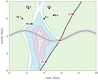
A company drilling for water in the Varden Hills records where its boreholes meet the base of the limestone; its geologists also locate the fault where it crosses the ground. Coordinates are in metres east and north of the map’s south-west corner; elevations in metres above sea level. Part I uses the coloured geological map of Section 4.1.
Part I — Reading the map.
- List the units of the region from the oldest to the youngest.
- Which units does the river cut through, from west to east?
- Which unit occupies the core of the fold near ? What kind of fold is it?
- Which unit occupies the core of the fold near ? What kind of fold is it?
- Why are the schist and the granite visible only near the river, in the core of the first fold?
- What kind of contact separates the sandstone from the granite? Justify from the map.
The boreholes (depth to the base of the limestone, ground elevation ) and the three points F1–F3 where the fault crosses the top of the bedrock (F2, in the valley, lies under the thin alluvium, which the fault does not cut):
| east | north | |||
|---|---|---|---|---|
| E1 | 4000 | 6000 | 435 | 261 |
| E2 | 4600 | 7200 | 432 | 428 |
| E3 | 5100 | 6400 | 512 | 586 |
| W1 | 1500 | 6000 | 524 | 669 |
| W2 | 2200 | 7200 | 421 | 459 |
| W3 | 2600 | 5400 | 319 | 209 |
| east | north | |||
| F1 | 4197 | 1000 | 405 | |
| F2 | 5824 | 3500 | 129 | |
| F3 | 7321 | 6500 | 482 |
Part II — The east limb.
- Compute the elevation of the base of the limestone in E1, E2 and E3.
- Write the vectors and .
- Compute their cross product and orient it upward.
- Deduce the dip of the base of the limestone on the east limb.
- Deduce its dip direction, then its strike by the right-hand rule.
- Is the result consistent with the strike-and-dip symbol of the east limb on the map?
Part III — The fold.
- Compute the elevations of the base of the limestone in W1, W2 and W3.
- Compute an upward normal to the base of the limestone on the west limb.
- Deduce the attitude of the west limb.
- Compute a direction of the intersection of the two limbs, the fold axis, as (with from question 9).
- Give the trend (the azimuth of the axis’s horizontal projection, taken downward) and the plunge (its angle below the horizontal) of the fold axis.
- The base of the sandstone lies on the axis at where the river crosses it, near . How much lower is it on the axis farther north? Is this consistent with question 3 of Part I and with the closure of the outcrops?
Part IV — The fault and the history.
- From F1, F2 and F3, compute the attitude of the fault.
- Along the fault, the units at the surface on the east-south-east side are younger than those opposite them. Which block moved down? Is the fault normal or reverse?
- The straight line from F1 to F3 passes about west of F2. Why does the trace of the fault bend toward the east-south-east where it crosses the river valley, at F2?
- Put in order: folding; deposition of the chalk; faulting; intrusion of the granite; erosion before the sandstone; deposition of the alluvium.
- The chalk is 90 million years old and is folded; the alluvium was laid down in the last 2.58 million years and is not faulted. Between what ages did the folding and the faulting take place?
- To reach the fault at below sea level beneath F1, how far from F1, and in which direction, must a vertical well be drilled?
Solution
Solution of Problem 4.1.
1. Schist, granite, sandstone, limestone, shale, chalk, alluvium.
2. From west to east: chalk and shale, limestone, sandstone, then schist and granite near , sandstone, limestone and shale again, then chalk; alluvium along the whole floor.
3. The sandstone, with the schist and the granite beneath it along the river: the oldest units in the core, an anticline.
4. The chalk, the youngest unit: a syncline.
5. The base of the sandstone is highest on the anticline’s axis, and only along the river has erosion cut down below it.
6. An unconformity: the sandstone rests on two different older units, schist and granite, and cuts off the outline of the granite.
7. , , .
8. , .
9. The cross product is
oriented upward, .
10. ; , .
11. Azimuth of : ; attitude , strike .
12. Yes: the symbol on the east limb has a strike line near north–south and a dip tick to the east, labelled 12.
13. , , .
14. and . Their cross product, oriented upward, is
15. , ; dip direction: azimuth of , . Attitude , strike : the west limb dips west-north-west, the east limb east-north-east.
16. (rounded).
17. The downward direction is : trend , that is north; plunge . The axis plunges toward the north.
18. lower, near . The anticline’s core is highest near the river and sinks to the north, so its outcrop closes to the north, as the map shows.
19. and give the upward normal
and a dip direction . Attitude , strike .
20. The fault dips toward the east-south-east, so that side is the hanging wall, the block lying above the dipping fault plane; it moved down (younger units at the surface): a normal fault.
21. The fault plane dips east-south-east, downstream and far more steeply than the river’s floor descends: lower ground meets the plane farther down-dip, so the trace swings east-south-east in the valley — the V-rule applied to the fault plane.
22. Intrusion of the granite; erosion before the sandstone; deposition of the chalk; folding; faulting; deposition of the alluvium.
23. After 90 million years ago (the chalk is folded) and before 2.58 million years ago (the alluvium is not faulted); the folding came first, the faulting after it.
24. The fault descends from F1 () to ; at a dip of that takes a horizontal distance of down-dip. The well must be drilled about east-south-east of F1 (azimuth ).