书籍暂未推出简体中文版——当前显示英文版。
University Earth and Space Sciences — Year 1 · 本科一年级
13Rifts, Ridges and Passive Margins
In September 2005 the ground of the Afar desert, in the north-east of Ethiopia, opened. Within three weeks a stretch of the rift some long widened by up to , and about of magma rose into the crack from below. The plates there separate at about a year: the crisis released, in a few weeks, the stretching of some four centuries. Afar is a continent breaking apart; a few hundred kilometres to the north, the Red Sea is a young ocean whose floor is already made like the floor of the Atlantic, and the South Atlantic was such a rift before it opened, about 120 million years ago. This chapter follows the birth of an ocean: the stretching of a continent, its break-up, the two passive margins left behind, the ridge that builds the ocean floor, and the slow sinking of that floor as it cools.
You already know
The plates are the upper thermal boundary layer of the mantle; under the oceans a cooling half-space describes them, and their isotherms deepen as the square root of age (Chapter 10). Columns of rock in isostatic equilibrium have the same mass per unit area above a compensation depth (Chapter 11). Plates turn about Euler poles, ridges spread at rates read from magnetic anomalies, and transforms lie on small circles about the pole (Chapter 12). The throw and the heave of a fault were defined in Chapter 5; a normal fault is an inclined fault whose upper block has moved down (Book 2, grade 11).
13.1 Continental rifting
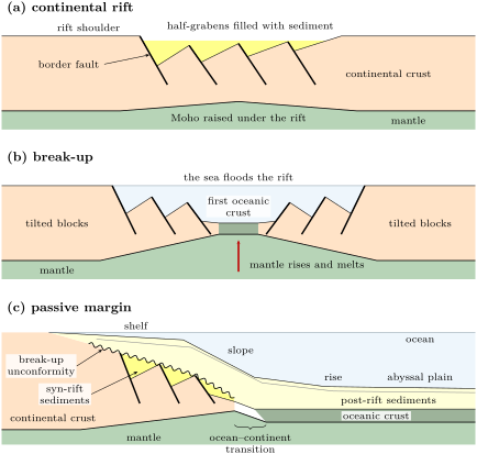
A continent stretched by forces at its edges does not thin evenly. Its brittle upper crust breaks along normal faults, and the blocks between them sink and tilt; below, the warmer lower crust and the mantle flow.
Definition 13.1 (Continental rift, graben, half-graben)
A continental rift is a long, narrow zone where a continent is being stretched: a depression bounded by normal faults, with earthquakes and, often, volcanoes. A graben is a block dropped between two normal faults that dip towards each other. A half-graben is a block dropped and tilted against a single major normal fault, the border fault, on one side only.
Most rift basins are chains of half-grabens. Their border faults hand the displacement over to one another through relay ramps, and the side of the border fault often alternates from one segment to the next. The hanging wall of each border fault tilts down towards it, and the basin fills fastest there: the thickest sediment piles up against the fault, while the footwall is raised into the rift shoulder.
The horizontal stretching carried by a fault is its heave. A planar normal fault of throw and dip has the heave (Chapter 5); adding the heaves of the faults across a rift section gives the extension of the brittle crust. How the whole lithosphere thins as it is stretched, and why it then subsides, is quantified in the Year 2 volume; here the faults are measured, and their sum compared with the motion of the plates.
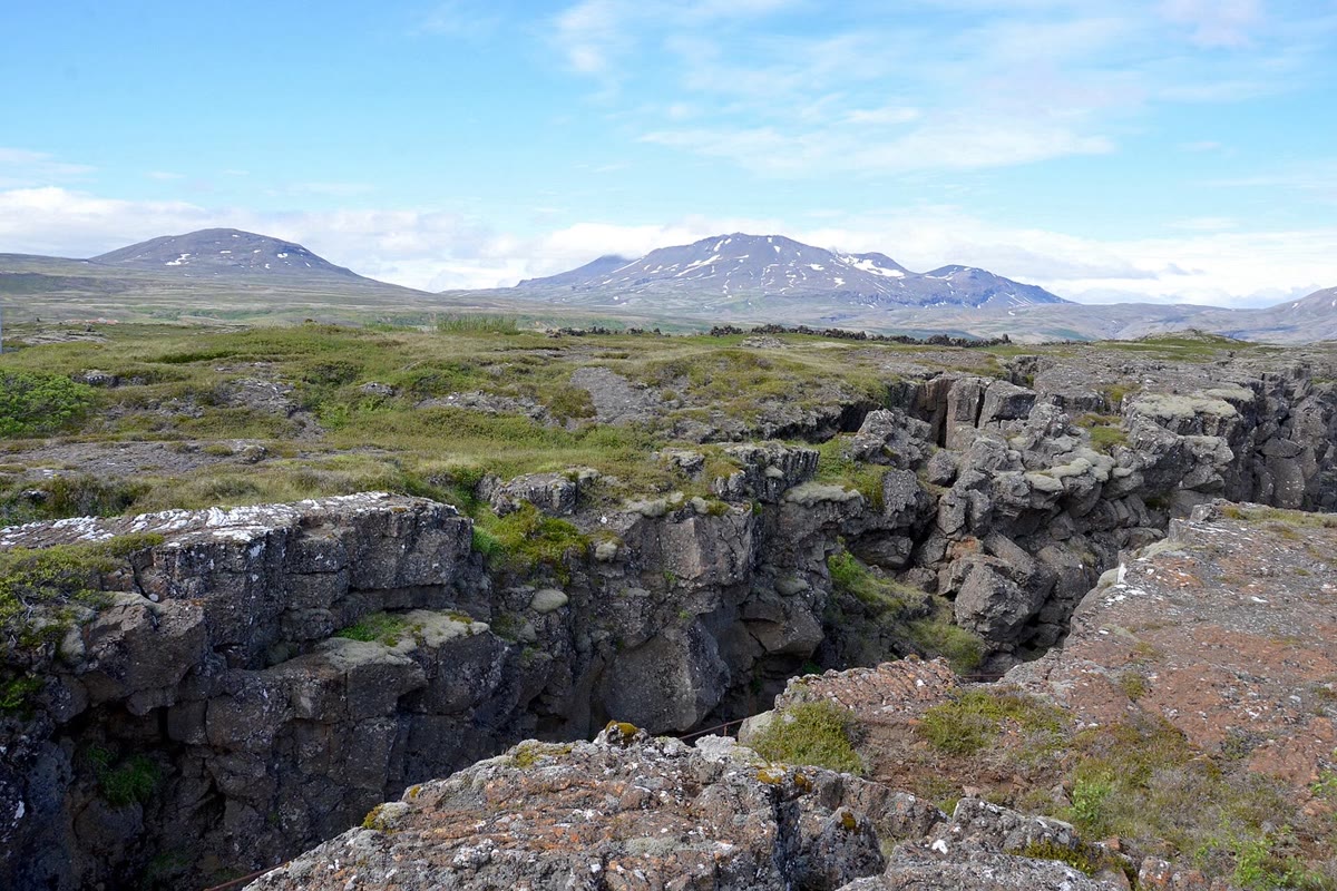
Volcanic and magma-poor rifts
Rifts differ in how much magma they receive. In a magma-poor rift the stretching is taken up by faults, and the crust thins as the blocks slide apart. In a volcanic rift magma takes over: dykes intrude the crust along the axis, each one opening the rift by its own thickness, and lavas flood the surface. The East African Rift shows both, side by side: its eastern branch is strongly volcanic, while its western branch is less so and holds deep sedimentary basins, filled by lakes such as Lake Tanganyika and bounded by faults.
Both branches began to form about 25 million years ago, and the rift splits the African plate into a Nubian plate to the west and a Somali plate to the east. From the Afar triple junction it runs south, in two branches around the old, thick and cold Tanzania craton. Its motion is slow: computed from the plate vectors of Somalia and Nubia, each measured relative to the Antarctic plate, Somalia moves away from Nubia at towards in central Ethiopia ( N, E), and at on the equator. Many earthquakes of the rift show normal faulting.
In Afar, at the northern end, the rift meets the Red Sea and the Gulf of Aden. The bulk of the Ethiopian flood basalts erupted there about 30 million years ago, in a million years or less, and magma has kept arriving since: lava flows at the surface, intrusions in the crust and new material added below it, so much that the intruded crust has kept its thickness through the early stages of rifting. The crisis of 2005 shows how such a rift opens: not steadily, but in episodes, each a dyke metres wide intruded within days or weeks. Since the plates diverge at about there, the dyke of 2005 took up the stretching of about 440 years.
13.2 Break-up and passive margins
If stretching goes on, the continental crust is thinned to nothing, the mantle rises beneath the rift and melts as it rises, and the first oceanic crust forms between the two halves of the continent. That moment is the break-up. From then on the plates move apart at a ridge in the middle of a new ocean, and the two edges of the continent, carried away from the ridge, stop being plate boundaries.
Definition 13.2 (Passive margin, ocean–continent transition, break-up unconformity)
A passive margin is the edge of a continent that was formed by rifting and is no longer a plate boundary: the continent and the adjacent ocean floor belong to the same plate. The ocean–continent transition is the zone of the margin, kilometres to tens of kilometres wide, between thinned continental crust and normal oceanic crust. The break-up unconformity is the unconformity that separates the sediments deposited in the rift basins, tilted with their blocks, from the undisturbed sediments laid over the margin after break-up.
Passive margins line most of the Atlantic, the Arctic Ocean and the western Indian Ocean, and nearly all the coasts of Africa, Australia, Greenland and India. The eastern margin of North America and the north-western margin of Africa were the two sides of one rift: they are conjugate margins. Their profile is the familiar sequence of the ocean floor near land: continental shelf, slope, rise and abyssal plain. Under the shelf and slope lies the thinned continental crust, cut by normal faults that dip towards the ocean, with its rotated blocks buried beneath the sediments.
Two kinds of margin
Margins inherit the character of their rift. On magma-poor margins, such as those of Iberia and Newfoundland, the seismic sections show rotated blocks whose beds dip towards the continent; in places the ocean–continent transition is floored by mantle peridotite, brought up to the sea floor and altered by sea water to serpentinite. On volcanic margins, such as the mid-Norwegian, East Greenland, Namibian and Brazilian margins, the transition is built of basalt: stacks of lava flows that dip towards the ocean, the seaward-dipping reflectors of seismic sections, and below them a lower crust in which P waves travel unusually fast, magma added beneath the crust at break-up. Volcanic margins subside little during break-up.
In the field — Finding the edge of a continent
The ocean–continent transition lies under kilometres of water and sediment, and is located only by geophysics, usually by several methods together. Seismic reflection images the tilted blocks, the break-up unconformity and, where the signal reaches deep enough, the Moho. Wide-angle seismic refraction measures the speeds of P waves through the crust, which differ between continental and oceanic crust. Gravity data, inverted for the depth of the Moho, give the thickness of the crust. The magnetic stripes of the ocean floor stop where the continental crust, magnetically quiet, begins.
After break-up a margin sinks. During rifting the lithosphere was thinned and heated; carried away from the ridge, it cools and contracts, like the ocean floor beside it, and the space that opens above it fills with the wedge of post-rift sediments, whose weight presses it down further. The cooling half of this story is told in Section 13.4; the weight of the sediments is the subject of Chapter 23.
13.3 Fast and slow ridges
Once the ocean is born, it grows at its ridge. Ridges spread at very different rates: the rates measured over the last few million years run from in the northern Red Sea to on the East Pacific Rise. Their shape depends on that rate.
Definition 13.3 (Fast-, slow- and ultraslow-spreading ridges)
A ridge is classed by its full spreading rate. An ultraslow-spreading ridge opens at less than about ; a slow-spreading ridge at 20 to ; an intermediate ridge at 55 to ; a fast-spreading ridge at more than about .
The limits are conventions and vary between authors. What does not vary is the change of form. A slow ridge, such as the Mid-Atlantic Ridge, has an axial valley between inward-facing normal faults: the gap between the plates is not filled by magma as fast as it opens, and the cold lithosphere breaks. A fast ridge, such as the East Pacific Rise, has no rift valley but a smooth axial high over a lens of melt, refilled often enough to keep pace. Either way the axis lies about deep, and the oldest floor of the basins nearly deeper (Section 13.4).
Ultraslow ridges show what happens when magma is scarcest: their volcanism is intermittent, they lack transform faults, and over large regions the mantle itself is brought up to the sea floor. The Gakkel Ridge, under the Arctic Ocean, the slowest of all, is not offset at all; along a central stretch of its axis some long, mantle peridotite lies directly on the axis, between abundant volcanism to the west and large, widely spaced volcanoes to the east. On slow and ultraslow ridges especially, part of the spreading is taken up by long, gently dipping normal faults, detachments, whose footwall is pulled out from under the axis: gabbro and peridotite reach the sea floor in corrugated domes, oceanic core complexes. The Atlantis Massif, beside the Mid-Atlantic Ridge near N, is one: on its top, on crust old about from the axis, sea water reacting with the mantle rock feeds the warm, alkaline springs of the Lost City hydrothermal field.
The oceanic crust
Definition 13.4 (Oceanic crust, pillow lava, sheeted dyke complex)
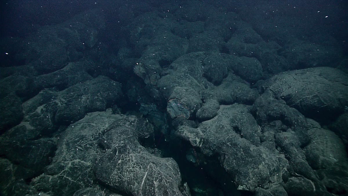
The oceanic crust is the crust made at ocean ridges: 6 to of basalt and gabbro, from the sea floor down to the Moho, beneath a cover of sediments. Pillow lava is lava erupted under water, made of rounded, interconnected tubes and lobes, each with a glassy skin chilled by the sea. A sheeted dyke complex is a layer made almost entirely of parallel vertical dykes, each intruded into the previous ones.
The layers of the oceanic crust were first defined by seismology, then sampled by drilling and recognised in slices of ocean floor thrust onto continents, the ophiolites. From the top:
- layer 1, sediments, thin or absent near the ridge and thickening with the age of the floor;
- layer 2, on average of basalt: pillow lava at the top (layer 2A), sheeted dykes of diabase below (layer 2B);
- layer 3, the remaining four to five kilometres, of gabbro and, at its base, cumulates settled from the magma: some of the thickness of the crust.
Beneath the Moho lies mantle peridotite, the residue left by the melting.
Seismic refraction gives the igneous crust a mean thickness of away from fracture zones and hot spots, and a later synthesis of seismic profiles , much the same at all spreading rates: the amount of melt depends on the temperature of the rising mantle, not on the speed at which it rises. Only very slow ridges make anomalously thin crust: the mantle there has time to cool as it rises, and melts less. Over a hot plume the crust is thicker, about directly above the rising core of a plume, as under Iceland (Chapter 15). Along all the ridges together, about of new sea floor and some of new crust are made each year.
Proposition 13.5 (Each dyke splits the one before)
Suppose that every dyke of a sheeted dyke complex is intruded along the axis of spreading, where the crust is hottest and weakest, and that the crust moves away from the axis symmetrically. Then most dykes are found split in two, each half with a chilled margin against its older neighbour only.
Proof. A dyke chills against the colder rock on both sides: it has two chilled margins when it forms. The next dyke rises where the crust is weakest, along the axis, that is, through the middle of the previous one, still the hottest rock. It splits it into two halves, which the spreading carries away on either side; each half keeps the chilled margin on its outer side and has, on its inner side, the uncooled contact with the new dyke. Every dyke but the last is split in this way. ∎
Dykes with a chilled margin on one side only are indeed the rule in sheeted dyke complexes: the signature of a crust built, dyke after dyke, by spreading.
13.4 The depth–age law
Ocean floor is shallow at the ridge and deep far from it. Since floor is made at the ridge and carried away, distance from the ridge is age, and the depth of the floor depends on its age. The plate cools from above as it ages (Chapter 10); cold rock is denser, and a denser column floats lower.
Lemma 13.6 (An integral of the error function)
With ,
Proof. The derivative of is . Integrating by parts on ,
For and , , so , which tends to 0. Letting gives the result. ∎
Theorem 13.7 (Depth–age law)
Suppose that
- the mantle leaves the ridge at the uniform temperature , and the oceanic plate of age is a half-space cooled since then from its surface, held at , with the thermal diffusivity ;
- the density of the cooled rock is , with the density of the mantle at and its coefficient of thermal expansion;
- every column is in isostatic equilibrium above a compensation depth lying below the cooled layer, and sea water has the density .
Then the depth of the sea floor of age is
where is the depth of the ridge axis. This is the depth–age law of the ocean floor.
Proof. The temperature in the cooled half-space is
with the depth below the sea floor; this solution of the heat equation is admitted here, as in Chapter 10, and derived in the Year 3 volume. Compare the column at the ridge, made of water down to and of mantle at below, with the column of age , made of water down to and of the cooled plate below, both down to the compensation depth . Their masses per unit area are equal:
Hence
Since is negligible below the cooled layer, the integral may be taken to infinity; with and Lemma 13.6,
Dividing by gives . ∎
The water matters: as the plate sinks, water fills the space above it, and its weight presses the plate further down. The effective expansion coefficient is larger than by the factor .
With , , , and , and time counted in millions of years (), the theorem gives . The constants fitted by Parsons and Sclater to the depths of the North Pacific and the North Atlantic, once the sediments are removed, are close: and , from 0 to . The values of and used above are those of their plate model for old floor, a mantle at and , uncertain by a fifth and a third respectively, so that the agreement of 393 with 350 is as good as could be hoped.
Example 13.8 (Ocean floor 25 and 100 million years old)
With (metres, in millions of years), floor old lies at and floor old at . The floor sinks in its first 25 million years, and only more in the next 75.
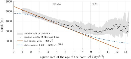
The figure tests the theorem on the whole ocean. Up to about () the medians lie within about a hundred metres of the law. A straight line fitted to the medians younger than has a slope of only : the measured depths are those of the sediment surface, while the law gives the depth of the top of the crust, and the sediment cover thickens with age. Between 60 and , the floor departs from the square-root law even after its sediments are removed: it becomes shallower than the law, and stops sinking. The plate model, a plate thick whose base is held at the mantle temperature, describes this flattening: its depth tends to about , and its heat flow to a constant, as if heat were supplied to the base of old plates by the convecting mantle. That model is studied in the Year 3 volume; in this book the square-root law is used up to .
Method 13.9 (Dating ocean floor from its depth)
To estimate the age of ocean floor where its magnetic anomalies are absent or unmapped:
- measure the depth of the floor and, from seismic profiles, the thickness of its sediments; take the depth of the top of the crust, corrected for the weight of the sediments;
- invert the law: , with and for the ocean concerned;
- check that the floor is younger than about , and estimate the uncertainty: an error on the depth gives .
For floor at , , and an uncertainty of on the depth gives on the age. Where floor is shallower than the law predicts over a broad region, a swell, the cause is not age but heat from below (Chapter 15).
The law also links the ocean to the sea level. A ridge that spreads faster carries young, shallow floor farther from its axis; the ocean basins hold less water, and the sea rises over the continents. Over tens of millions of years, changes in spreading rate are one of the two main causes of the changes of global sea level, with the volume of ice on land.
13.5 Transform faults and fracture zones
Ridges are not continuous lines: they are cut into segments offset by faults that run at right angles to them, along the direction of spreading. Beyond the offsets, the faults continue as long scars across the ocean floor.
Definition 13.10 (Transform fault, fracture zone)
A transform fault is a strike-slip fault that is a plate boundary and ends at other plate boundaries; a ridge–ridge transform links the ends of two offset ridge segments. A fracture zone is the continuation of a transform fault beyond the ends of the ridge segments: a linear valley or step across the ocean floor separating floor of different ages that belongs to a single plate.
Proposition 13.11 (Slip on a ridge–ridge transform)
Two ridge segments spreading symmetrically at the half rate , perpendicular to themselves, are offset by a transform fault of length . Then:
- the two sides of the transform slip past each other at the full rate , in the sense opposite to the one the offset would suggest if a single straight ridge had been cut and displaced by the fault;
- along the fracture zones the two sides do not move relative to each other, and the floor on the two sides differs in age by ;
- the length of the transform does not change with time.
Proof. Take the axis along the transform, towards the east, and the axis towards the north, in the frame of the ridge. Let the northern segment lie on , , and the southern one on , (the offset is to the east going south); the transform is the segment of . The western plate lies west of both segments and moves at along ; the eastern plate lies east of both and moves at .
(1) Just north of the transform, at , the floor lies east of the northern segment: it belongs to and moves east at . Just south of it, the floor lies west of the southern segment: it belongs to and moves west at . The northern side moves east at relative to the southern side: seen from either side, the far side moves to the right, and the slip is right-lateral (dextral). A straight ridge cut by the fault, its southern part now east of its northern part, would instead record a left-lateral (sinistral) displacement.
(2) For , both sides lie east of their segments and belong to : they move together. At the distance from the northern segment, floor north of the fracture zone has the age ; floor south of it is at from the southern segment and has the age . The difference is . The same holds for , where both sides belong to .
(3) Both segments stay at and in the frame of the ridge, since each spreads symmetrically: the transform keeps the length . ∎
J. Tuzo Wilson saw in 1965 that offsets of ridges cannot be read as the displacement of an older, straight ridge, and predicted the sense of slip of the proposition; the focal mechanisms of earthquakes on transforms confirmed it. Earthquakes occur along the active transform, between the ridge ends; the fracture zones are usually quiet. Across a fracture zone the floor of the two sides has different ages, hence, by the depth–age law, different depths: a step that fades slowly with distance from the ridge. In the North Atlantic near N, the two Charlie–Gibbs transforms offset the Mid-Atlantic Ridge by about in all.
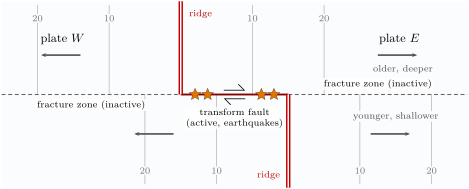
Transforms are the third kind of evidence for the plate motions of Chapter 12: a transform runs along the relative velocity of the two plates, so it lies on a small circle about their Euler pole, and the great circles drawn perpendicular to several transforms meet at the pole. Fracture zones, traced across the ocean floor, record the direction of motion in the past, as the magnetic anomalies record its rate.
13.6 Exercises
Exercise 13.1 ★
In 2005 a segment of the Afar rift long opened by up to , and of magma was intruded. (a) If the dyke had been thick along the whole segment, what would its mean height have been? (b) At the plate rate of , how many years of motion does an opening of represent?
Solution
Solution of Exercise 13.1.
(a) The dyke would cover in plan, so its mean height would be , about : the dyke cut through much of the crust. (b) years, some four centuries.
Exercise 13.2 ★
A half-graben is bounded by a border fault of throw dipping , and cut by a smaller antithetic fault of throw dipping . (a) Compute the heave of each fault and the extension of the section. (b) The section is now wide: how wide was it before the faulting?
Exercise 13.3 ★
Class the following ridges with the limits of the definition, from their full spreading rates computed with plate vectors: Gakkel Ridge ; central Red Sea ; Reykjanes Ridge ; western Carlsberg Ridge ; South Atlantic at S ; East Pacific Rise at S . Which of them would you expect to have an axial valley, and which an axial high?
Solution
Solution of Exercise 13.3.
Ultraslow (below ): the Gakkel Ridge (12), the central Red Sea (15) and the Reykjanes Ridge (19), the last close to the limit. Slow (20 to ): the western Carlsberg Ridge (23) and the South Atlantic (33). Fast (above ): the East Pacific Rise (143). The ultraslow and slow ridges should have an axial valley between normal faults; the East Pacific Rise an axial high.
Exercise 13.4 ★
About of new ocean floor is made each year, with a crust thick. (a) What volume of crust is made each year? (b) At this rate, how long would it take to make the of the ocean floor? Compare with the age of the oldest ocean floor, about , and explain why the two need not agree.
Solution
Solution of Exercise 13.4.
(a) , about a year. (b) , . The oldest floor, about , is older because the floor is not destroyed in order of age: subduction consumes floor of every age, some old floor survives where no trench has reached it, and the rate of production has varied.
Exercise 13.5 ★★
With (metres, in millions of years): (a) compute the depth of floor 4, 36 and 64 million years old; (b) find the age of floor lying at and at ; (c) by how much does the floor sink between 4 and , and between 36 and ?
Solution
Solution of Exercise 13.5.
(a) , , . (b) : and . (c) The floor sinks between 4 and , but only between 36 and , over a similar length of time.
Exercise 13.6 ★★
Compute the constant of the depth–age law (Theorem 13.7) for , , , and , in . Redo it for a mantle colder. Which constant would the floor of a colder ocean follow?
Solution
Solution of Exercise 13.6.
The effective expansion coefficient is , and . Then . For a mantle colder, scales with : . The floor of a colder ocean sinks more slowly and follows the smaller constant. The fitted of the chapter is not such a case: it lies within the uncertainty of the parameters.
Exercise 13.7 ★★
The plate model gives the heat flow of the ocean floor as , in units of , with in millions of years. (a) Convert the constant to () and compare it with the of Chapter 10. (b) Compute at 1, 10 and . The law was fitted to floor up to old, and the plate model makes the heat flow of older floor level off at a constant: is the value at then too high or too low?
Solution
Solution of Exercise 13.7.
(a) , so the constant is , below the 490 of Chapter 10: the two fits agree. (b) , and . The square-root law keeps falling, while the plate model levels off at a constant: at the square-root value is too low, as the depth law goes too deep.
Exercise 13.8 ★★
A ridge trending north–south is cut into two segments; going south along the ridge, the axis jumps to the west at a transform fault. (a) What is the sense of slip on the transform? (b) What does the offset of the ridge seem to show? (c) Where along the line of the transform do earthquakes occur, and why not beyond?
Solution
Solution of Exercise 13.8.
Take the northern segment on and the southern one on (km), the transform on between them. (a) Just north of the transform the floor lies west of the northern segment and moves west; just south of it, it lies east of the southern segment and moves east. Seen from either side, the far side moves to the left: the slip is left-lateral (sinistral). (b) The ridge seems to have been displaced right-laterally, its southern part to the west: the opposite sense, as Proposition 13.11 predicts. (c) Earthquakes occur only on the between the two ridge ends, where the two sides belong to different plates; beyond, along the fracture zones, both sides belong to the same plate and move together.
Exercise 13.9 ★★
The Charlie–Gibbs fracture zones offset the Mid-Atlantic Ridge by in all; the full spreading rate there is . Treat the offset as a single transform. (a) What is the difference in age across the fracture zone? (b) Using , compute the depth step across the fracture zone at the end of the transform, then and beyond it.
Solution
Solution of Exercise 13.9.
The half rate is , . (a) The age step is . (b) At the end of the transform, floor old () faces floor of age 0 (): a step of about . beyond, the ages are and , the depths 4781 and : a step of about . beyond, the ages are 127.4 and , the depths 6450 and : . (These ages are beyond , where the square-root law goes too deep; the plate law would give a smaller step.)
Exercise 13.10 ★★★
An ocean basin is made at a constant rate and holds floor of every age from 0 to in equal areas. (a) Show that its mean depth is . (b) With and , compare and . (c) If the spreading of the basin speeds up so that its oldest floor is instead of , by how much does sea level rise, neglecting the flooding of the continents but allowing for the load of the extra water on the floor, which sinks by times the rise (, )?
Solution
Solution of Exercise 13.10.
(a) With equal areas for every age, the mean depth is the mean of over :
(b) For : ; for : , shallower. (c) Let the sea rise by and the loaded floor sink by . The water, unchanged in volume, must fill the same depth over the same area, so , , and : hundreds of metres, from the spreading rate alone.
Exercise 13.11 ★★★
In the setting of Proposition 13.11, the depth step across a fracture zone at the distance from the farther ridge segment is . (a) Show that, for , . (b) With , and , compare the exact and approximate steps at , 1350 and . When is the approximation good to ?
Solution
Solution of Exercise 13.11.
(a) for , so . (b) At : exact , approximate ; at : and ; at : and . The ratio of the approximate to the exact step depends only on : , which is 0.9 for . The approximation is good to beyond , about three offsets from the ridge.
Exercise 13.12 ★★★
Compare the half-space law with the plate law . (a) Compute at 10, 20, 30 and . (b) Show that the two laws are equal at one age between 20 and and find it to by bisection. (c) Compare their slopes there. Why may the two laws be joined at that age without a visible break?
Solution
Solution of Exercise 13.12.
(a) at ; at 20; at 30; at 40. (b) is positive at 20 and negative at 30, and both laws are continuous: they are equal in between. Bisection: at 25, ; at 27.5, ; at 26.25, ; at 26.875, ; at 26.56, ; at 26.41, ; at 26.33, : the root lies between 26.25 and 26.33, at , where both give . (c) and . The laws have nearly the same value and the same slope there, so the joined curve has no visible kink.
13.7 Problem: The birth of an ocean
Problem 13.1
Weekend problem — a continent stretched by its faults, a young ocean measured by its stripes, and the depth of its floor as it ages
Take . An ocean is born in three stages, each seen today in a different place: a continental rift, a young ocean, an old ocean.
Part I — A rift stretched by its faults. A section across a rift trending crosses six normal faults whose throws and dips were measured on seismic profiles:
The faults cut lavas dated , and the rift is now wide.
- Compute the heave of each fault. Which is the border fault?
- Compute the extension of the section, and the width of the rift before the faulting.
- The two plates separate at towards . Compute the component of this motion perpendicular to the rift.
- How long would the plates take to produce the extension of question 2?
- How much have the plates moved apart since the lavas were erupted? What fraction of it do the faults carry?
- Suggest where the rest of the extension has gone. If it were taken up by dykes like that of Afar in 2005, wide, how many would be needed, and how often?
Part II — A young ocean measured by its stripes. A magnetic profile across the axis of the central Red Sea, at N, E, runs along the direction of spreading. The young edge of chron C2An () lies north-east of the axis and south-west of it; the old edge of chron C3n () lies at and . The edges of anomalies are displaced outward from the axis by in all, on average, over both flanks.
- Compute the full spreading rate from each chron, without correction.
- Correct each rate for the outward displacement. Do the two agree?
- Show that the rate computed from the distance between the two chrons on each flank needs no correction, and compute it.
- Compute the half rates on each flank from the distances between the two chrons. Is the spreading symmetric?
- The Euler pole of Arabia relative to Nubia is at N, E, with the rate . Compute the angular distance from the pole to the profile, and the full spreading rate the plate vector predicts there.
- In the northern Red Sea, at N, E, compute the angular distance from the pole and the predicted rate.
- Compare these rates with those measured, 15 and . Why does the Red Sea open faster in the south?
Part III — Towards an Atlantic.
- How wide is the oceanic floor made in the central Red Sea since the old edge of C3n, at the rate of question 9?
- The South Atlantic opened by about at Recife in (Chapter 12). Compute its mean rate of opening.
- At the present rate of the central Red Sea, how long would an opening of take? And at the rate of the northern Red Sea?
- The Red Sea opens about a pole close to it. What does this imply for its shape as it widens, and for the time the northern part needs to reach the width the central part has now?
- Which kind of ridge is the Red Sea axis, and which form of axis do you expect?
Part IV — The floor sinks. Use (metres, in millions of years) and, for comparison, the plate law .
- Compute the depth of the new floor at the ages of 1, 10 and .
- At what age does the floor reach ?
- The floor next to each passive margin is as old as the ocean. By how much does it sink in the first after break-up, and between 70 and ?
- At what rate, in metres per million years, is that floor sinking when the ocean is old?
- What heat flow does the floor of question 22 lose then, with in ?
- Compute the depth of floor old with each of the two laws, and their difference. Why may the two be compared at this age?
- To the nearest tenth of a kilometre, how deep does the square-root law put the sea floor of the new ocean when it is 80 million years old?
Solution
Solution of Problem 13.1.
1. Heave throw(dip): F1 , F2 , F3 , F4 , F5 , F6 . F3, with the largest throw and heave, is the border fault.
2. The extension is the sum, , about . The rift was wide before the faulting.
3. The normal to a rift trending points to ; the motion, towards , makes with it. The perpendicular component is .
4. .
5. In the plates moved apart by across the rift. The faults carry of it.
6. The other three quarters, , are not in the faults of the section. They may be taken up by dykes intruded along the axis, which open the rift without faulting it, as in Afar, or by faults outside the section. With dykes wide, dykes are needed, one every years on average.
7. From C2An: . From C3n: .
8. and : corrected, the two agree to . The correction matters more for the younger chron, whose distance is shorter.
9. The outward displacement shifts both edges of a flank by the same amount, so it cancels in their difference. Over both flanks, .
10. North-east: ; south-west: . The spreading is symmetric; the difference between the flanks, the same for both chrons, is a constant shift, such as the axis being placed off centre.
11. , so . With , the rate is , the corrected rates of questions 8 and 9.
12. , so and the rate is .
13. The predictions, 15.1 and , match the measured 15 and . The rate is , and the pole lies north-west of the Red Sea, in north-eastern Libya: the farther south, the farther from the pole, the faster the opening.
14. of oceanic floor.
15. , on average.
16. at the central rate; at the northern rate.
17. Opening about a nearby pole, the Red Sea widens like a pair of scissors: its width grows in proportion to , and it stays a wedge narrowing towards the pole. At , the northern part needs to make the of oceanic floor the central part has now.
18. At the Red Sea axis is an ultraslow ridge; an axial valley between normal faults is expected.
19. ; ; .
20. .
21. In the first it sinks ; between 70 and , , five times less over the same time.
22. , about a year.
23. .
24. Square-root law: . Plate law: . They differ by . At both laws still apply: the square-root law up to about , the plate law from about ; beyond, the square-root law goes too deep.
25. The square-root law gives : to the nearest tenth of a kilometre, the floor of the new ocean lies at a depth of when it is 80 million years old (the plate law gives ).