书籍暂未推出简体中文版——当前显示英文版。
University Earth and Space Sciences — Year 1 · 本科一年级
6Field and Lab Methods I
A geologist mapping the Varden Hills carries little: a notebook, a pencil, a satellite receiver, a compass-clinometer, a hand lens and a few sample bags. With them she fixes where she stands, measures the attitude of the beds, names the rocks, and brings back the samples that the laboratory will cut, grind and look at through a microscope. Every number of the earlier chapters — an attitude on a map, a dip in a section — began as a reading of this kind, with its own error. This chapter describes how professionals make these observations, and how repeated readings are averaged and their scatter turned into an uncertainty. It ends with a season of readings on the east limb of the Varden anticline.
You already know
The attitude of a plane is written dip direction/dip, as , or as a strike by the right-hand rule with a dip (Chapter 4). The magnetic declination is the angle between geographic north and the direction in which a compass needle points (physics, grade 11). Minerals are recognised in the hand by their lustre, cleavage, hardness and colour (Book 2, grade 11). The mean and the standard deviation of a set of numbers summarise their centre and their scatter (mathematics).
6.1 The notebook and the map
Definition 6.1 (Field station, field notebook)
A field station is a numbered place where a geologist makes and records observations: its position, the rocks seen, their attitude, and the samples taken. The field notebook is the bound record of the stations, in the order they were visited, with their numbers, sketches and measurements, written on the spot.
The notebook is the primary record: what is not written at the station is lost, and a map drawn in the evening is only as good as the notes behind it. Each station has a number that appears on the field map, in the notebook, and on every sample bag taken there. A sketch shows what a list of numbers cannot — how two units meet, which way younger beds lie, where a reading was taken on a folded surface — and records its scale and orientation. Facts and interpretations are kept apart: “limestone on shale, contact sharp” is an observation; “unconformity” is an inference, written as such.
In the field — A day of mapping

A mapping geologist plans a traverse across the strike, so as to meet every unit in turn, and stops wherever a contact, a change of rock or a measurable surface appears. At each station she writes the station number and the position, sketches what she sees, measures attitudes, and notes the samples. Positions come from a satellite receiver: an ordinary receiver, such as a smartphone’s, is typically accurate to within about under open sky, worse near cliffs and trees, while survey receivers using two frequencies or correction services reach a few centimetres. At a map scale of 1:10 000, is half a millimetre: an ordinary receiver is good enough for mapping, but not for measuring the slow motion of the ground (Chapter 12).
6.2 Measuring orientations
The attitude of a plane — a bed, a fault, a joint — is measured with a compass-clinometer: a magnetic compass to read azimuths, and a pendulum or level to read angles from the horizontal. Its edge is laid along the strike of the surface to read the strike, or the instrument is set on the surface along its steepest line to read the dip and, from the azimuth of that line, the dip direction.
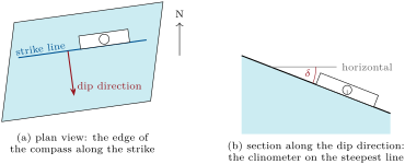
A line — a fold axis, a scratch on a fault surface, the long axis of pebbles — has an orientation of its own.
Definition 6.2 (Trend and plunge)
The trend of a line is the azimuth of its horizontal projection, measured toward the end of the line that points downward. Its plunge is the angle between the line and the horizontal, measured in the vertical plane that contains it. A line plunging toward is written .
A line of trend and plunge has the downward unit vector in east, north and up components; a line lying in a plane of dip direction and dip plunges by the apparent dip of that plane in the vertical plane of azimuth , so that (Theorem 5.4).
6.2.1 The magnetic declination
A compass needle points to magnetic north, not to geographic north; the angle between the two is the magnetic declination, counted positive when magnetic north lies east of geographic north. Maps and the attitudes of this book use geographic azimuths.
Method 6.3 (Correcting a compass azimuth)
- Find the magnetic declination for the place and the date, from a model of the Earth’s field (east positive, west negative).
- Add it to every azimuth read on the compass: geographic azimuth magnetic azimuth , taken modulo .
- Leave dips and plunges alone: they are measured from the horizontal, with gravity, not with the needle.
Most field compasses can be set to add mechanically; the setting, and the year it was made for, are written in the notebook.
Figures as of 2026
On 1 January 2026, the World Magnetic Model (version 2025) gives the magnetic declination as (west) at Edinburgh, changing by a year; at Reykjavik, changing by a year; (east) at Anchorage, changing by a year; and at Wellington. A geologist who forgot the correction at Wellington would misplace every azimuth by more than ; one who reused an Edinburgh setting from ten years before would carry an error of about .
6.2.2 Repeated readings
A single reading of a bedding plane carries errors: the surface is never a perfect plane, the instrument is not perfectly set, and the reading is rounded to the degree. A geologist therefore measures the same surface several times, or several surfaces of the same limb, and averages. Averaging azimuths needs care: the readings and describe directions apart, but their arithmetic mean, , points the opposite way. The right mean works with vectors.
Definition 6.4 (Mean orientation (vector mean))
For a plane of dip direction and dip , let
be its upward unit normal in east, north and up components. The mean orientation (or vector mean) of readings of normals is the plane whose normal is , where is their resultant; is the mean resultant length. The mean dip direction and dip are and .
That is the normal follows from Chapter 4: the plane has the upward normal , whose length is .
Proposition 6.5 (The vector mean is the closest direction)
Among all unit vectors , the mean normal maximises , where is the angle between and ; equivalently, it minimises . Moreover
so that , with only if all readings agree, and, when the scatter is small, the root-mean-square angle between the readings and their mean is
Proof. by the Cauchy–Schwarz inequality, with equality exactly when . Since , the two problems are the same. With the bound is reached: , which is the formula for . Finally for small , so . ∎
How do errors in the two angles move the normal? Differentiating ,
the first has length 1, the second length , and the two are perpendicular. Small errors and therefore turn the normal by the angle
On a gently dipping bed an error in the dip direction hardly changes the plane: on a bed dipping , a error in dip direction turns the plane by only . The converse is the field geologist’s difficulty: the dip direction of a gentle bed is poorly fixed by its plane, and small undulations of the surface scatter it widely. The standard error of a mean of independent readings of standard deviation is (mathematics): to halve it, four times as many readings are needed.
6.3 The hand lens and field identification
Most rocks are named in the field, before any laboratory work, from the minerals a hand lens shows and from the way the rock breaks. The geologist looks at a fresh surface, since weathering coats and discolours the rock, and notes the size of the grains (whether they can be seen with the naked eye, with the lens, or not at all), their shapes, whether they interlock like a mosaic or are cemented like sand, and any alignment. The minerals are recognised by the properties recalled at the start of the chapter: the glassy lustre and absence of cleavage of quartz, the two cleavages and dull whiteness of feldspar, the flakes of mica, the rhombic cleavage of calcite. Hardness is tried against a steel point: quartz is harder than steel and calcite much softer.
Professionals carry a small dropper bottle of dilute hydrochloric acid: a carbonate rock releases bubbles of carbon dioxide where the drop falls (chemistry). Calcite reacts briskly; dolomite reacts weakly unless powdered. The acid is handled with gloves and eye protection, and never by a reader of this book: the description is of professional practice.
6.4 Samples
Definition 6.6 (Oriented sample)
An oriented sample is a rock sample on which the geologist has marked, before removing it, the attitude of one of its surfaces (a strike line and a dip arrow, or the trend of a line), so that the sample can be put back in its field position in the laboratory.
A sample is useful only if it is representative of the unit it stands for — fresh, not weathered, not taken from a vein or a fallen block — and if its origin is certain. Each one receives the station number and a sample number, written on the rock and on the bag, and is listed in the notebook with its position, its unit and the reason it was taken. Samples for chemical or isotopic analysis, whose results may be published decades later, are tracked from the field to the laboratory by a written record of every hand they pass through — a chain of custody — so that no doubt remains about which rock gave which number. Oriented samples are needed whenever the direction of something inside the rock matters: an alignment of minerals, a fabric seen under the microscope, or the direction of the magnetisation the rock acquired when it formed.
6.5 Thin sections and the polarising microscope
Definition 6.7 (Thin section)
A thin section is a slice of rock, glued to a glass slide and ground to a standard thickness of , thin enough for most minerals to transmit light.
In the lab — Making a thin section

In the preparation laboratory, a technician cuts a small block from the sample with a diamond saw, grinds one face perfectly flat, and glues it to a glass slide with an epoxy resin whose refractive index, 1.54 to 1.55, is almost that of quartz. Most of the block is then sawn off, and the slice is ground down on a rotating lap with ever finer abrasive until it is thick. The technician checks the thickness under the microscope from the colours shown by quartz grains (Chapter 8), and finishes with a thin cover glass or a polished surface. Porous or crumbly rocks are first soaked in resin so that they hold together.
The thin section is studied with a microscope fitted with two polarising filters. Linear polarisation is the subject of physics: here it is enough that a polarising filter transmits only light vibrating in one direction, and that two filters set at right angles transmit nothing.
Definition 6.8 (Polarising microscope, plane-polarised light, crossed polars)
A polarising microscope is a transmitted light microscope with a polarising filter (the polariser) below a stage that rotates through against a graduated scale, and a second polarising filter (the analyser) between the objective and the eyepiece, which can be moved in or out of the light path, its vibration direction at right angles to the polariser’s. With the analyser out, the specimen is seen in plane-polarised light; with the analyser in, it is seen between crossed polars.
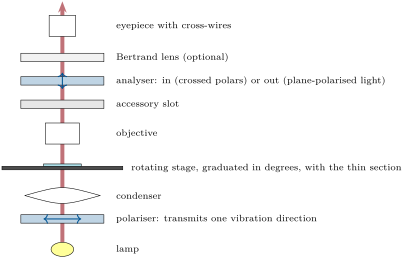
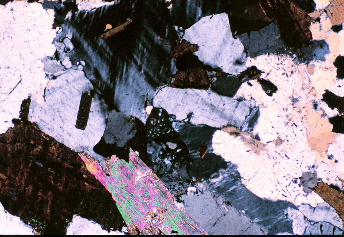
Between crossed polars, the glass of the slide, the epoxy and any isotropic mineral (one whose optical properties are the same in every direction, as in cubic crystals) stay black whatever the rotation of the stage. Most minerals are not isotropic: they change the polarisation of the light that crosses them, and appear in interference colours that change as the stage turns and vanish four times in a full turn. Why they do so, and how the colours and the angles identify a mineral, is the subject of Chapter 8. Minerals in thin section are usually examined at magnifications from about to .
Safety
Field and laboratory work are made safe by professional rules, not by luck. In the field, geologists work in pairs or leave a written plan of their route and return time; they carry weather forecasts, maps and first aid, keep away from the foot and the edge of cliffs and quarry faces, and wear a helmet and eye protection wherever rock can fall or splinter; work on active sites follows the operator’s rules. In the laboratory, saws and laps run behind guards with water to keep dust down, resins and acids are handled with gloves and goggles under extraction, and every chemical has its safety data sheet. None of these activities is for a reader of this book alone: the chapter describes professional practice.
6.6 Exercises
Exercise 6.1 ★
A satellite receiver gives positions within about . How large is that on a map at 1:10 000? At 1:25 000?
Solution
Solution of Exercise 6.1.
At 1:10 000, becomes ; at 1:25 000, , about the width of a pencil line.
Exercise 6.2 ★
A compass with no declination setting reads the dip direction on a bed. Give the geographic dip direction if the reading was made at Reykjavik on 1 January 2026, then at Wellington the same day (dated box).
Solution
Solution of Exercise 6.2.
At Reykjavik : . At Wellington : . The same compass reading means directions apart.
Exercise 6.3 ★
A fold axis plunges toward . Write its orientation as in the text and give its downward unit vector in east, north and up components.
Solution
Solution of Exercise 6.3.
. With and , the downward unit vector is
Exercise 6.4 ★
Three readings of a vertical joint give the azimuths of its normal , and . Compute their arithmetic mean, then the azimuth of the sum of the three horizontal unit vectors. Which mean is right?
Solution
Solution of Exercise 6.4.
The arithmetic mean is , nearly opposite to all three readings. The horizontal unit vectors add up to , whose azimuth is , that is : the right mean, in the middle of the readings.
Exercise 6.5 ★★
Five readings of the dip of one bed are , , , and . Compute their mean, their standard deviation and the standard error of the mean.
Solution
Solution of Exercise 6.5.
Mean . Deviations ; sum of squares 10; . Standard error .
Exercise 6.6 ★★
A geologist averages one reading on each limb of a symmetric fold: and . Compute the vector mean and . What has gone wrong?
Solution
Solution of Exercise 6.6.
The normals are and ; is vertical: the mean is a horizontal plane, and , each reading from the mean. The two readings do not sample one surface with errors: they belong to two limbs of a fold, two different populations, and their average describes neither. Each limb is averaged on its own; together they define the fold axis, the line common to both planes, here horizontal and north–south.
Exercise 6.7 ★★
Scratches on a bedding surface of attitude have the trend . What is their plunge? What would it be for the trend ?
Exercise 6.8 ★★
At Edinburgh the magnetic declination is on 1 January 2026 and changes by a year. Assuming the change stays steady, when does it reach zero, and what is it on 1 January 2030?
Solution
Solution of Exercise 6.8.
years after 1 January 2026, that is in spring 2028. On 1 January 2030: , east of geographic north.
Exercise 6.9 ★★
Three readings of one bed are , and . Show that their vector mean is , compute and the estimate of , and compare with the exact root-mean-square angle.
Solution
Solution of Exercise 6.9.
The three normals lie in the vertical plane of azimuth , at , and from the vertical; the outer two are symmetric about the middle one, so their sum lies along it: the mean is , with . Then , and ; exactly, .
Exercise 6.10 ★★★
A thin section cuts a spherical grain of radius at a distance from its centre, with equally likely anywhere between 0 and . Show that the mean radius of the circle seen in the section is . Quartz grains across appear on average how large in thin section?
Solution
Solution of Exercise 6.10.
The section is a circle of radius . Its mean is , since the integral is the area of a quarter disc. Grains across appear on average across: a thin section underestimates grain sizes.
Exercise 6.11 ★★★
Show that if every dip direction of a set of readings is increased by the same angle , the dip direction of their vector mean increases by and its dip does not change. Why does this matter for the declination correction?
Solution
Solution of Exercise 6.11.
The rotation by about the vertical, , sends to : it adds to every dip direction. Being linear, it sends the resultant to the resultant of the rotated normals; it keeps lengths and the vertical component, so the mean dip is unchanged, and it turns the horizontal part of by , so the mean dip direction increases by . Correcting each reading for the declination, or only their mean, gives the same result.
Exercise 6.12 ★★★
On a bed dipping , the normal of a single reading scatters with a standard deviation of in each of two perpendicular directions: along the line of steepest dip, which changes the dip, and across it, which changes the dip direction. How many readings are needed for a standard error of on the mean dip? Of on the mean dip direction?
Solution
Solution of Exercise 6.12.
The scatter along the line of steepest dip is a scatter of the dip: the standard error is for . Across it, a turn of the normal by changes the dip direction by ; the standard error of the mean dip direction is for , that is 93 readings. A gentle dip is quickly known; its direction is not.
6.7 Problem: A field season on the Varden east limb
Problem 6.1
Weekend problem — averaging twelve compass readings, measuring their scatter, correcting them, and comparing them with the boreholes
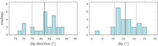
A geologist measured the bedding of the east limb of the Varden anticline at twelve stations, with a compass set for the declination, rounding to the degree. The table gives each reading (dip direction/dip) and the components of its upward unit normal , rounded to four decimals.
| reading | reading | ||||||||
|---|---|---|---|---|---|---|---|---|---|
| 1 | 0.1851 | 0.0462 | 0.9816 | 7 | 0.1894 | 0.0233 | 0.9816 | ||
| 2 | 0.2222 | 0.0352 | 0.9744 | 8 | 0.2064 | 0.0253 | 0.9781 | ||
| 3 | 0.2696 | 0.0573 | 0.9613 | 9 | 0.2071 | 0.0181 | 0.9781 | ||
| 4 | 0.1885 | 0.0298 | 0.9816 | 10 | 0.1866 | 0.0397 | 0.9816 | ||
| 5 | 0.1685 | 0.0420 | 0.9848 | 11 | |||||
| 6 | 0.2401 | 0.0295 | 0.9703 | 12 |
Part I — The mean attitude.
- Compute the arithmetic means of the twelve dip directions and of the twelve dips.
- Give an example of two readings for which the arithmetic mean of the dip directions is absurd, and say why it is safe here.
- Show that is a unit vector perpendicular to the dip line and to the strike line of the plane .
- Complete the table for readings 11 and 12.
- Compute the resultant of the twelve normals.
- Compute and the mean resultant length .
- Deduce the vector mean: its dip direction and its dip.
Part II — The scatter.
- Compute the sample standard deviations of the dip directions and of the dips.
- Using Proposition 6.5, estimate the root-mean-square angle between the readings and their mean, in degrees.
- Predict from the two standard deviations of question 8 and the error formula of the chapter, and compare.
- Which of the two standard deviations contributes most to , and why?
- Compute the standard errors of the mean dip and of the mean dip direction.
- Is the scatter of the dip directions, , a sign of careless measurement? Explain.
Part III — The declination.
- A second geologist forgot to set the declination. Her twelve readings have the vector mean in magnetic azimuths. Suppose the magnetic declination in the Varden Hills that year is west. What is her mean in geographic azimuths?
- Why is her mean dip right without correction?
- Could she have corrected each reading before averaging, rather than the mean? Does it change the answer (Exercise 6.11)?
- Ten years later, a student reuses her declination setting while the declination has changed by a year. How large is the error, compared with the standard error of question 12?
- Give the strike of the mean attitude of the first geologist by the right-hand rule.
Part IV — Compass and boreholes.
- From three boreholes, Chapter 4 found the attitude for the base of the limestone. Compare it with the vector mean of question 7, angle by angle.
- Compute the angle between the two normals.
- The standard error of the mean direction is about . Is the difference of question 20 significant?
- How many readings would halve that standard error?
- Name two errors that no number of readings would reduce.
- Give the mean attitude of the east limb from the twelve readings, in the form dip direction/dip rounded to the degree.
Solution
Solution of Problem 6.1.
1. Dip directions: ; dips: .
2. and average to , the opposite direction. Here all the dip directions lie between and , far from the jump at , so the arithmetic mean works.
3. . The downward dip line has the direction , and its dot product with is ; the strike line is horizontal and perpendicular to the dip direction, , and its dot product with is .
4. Reading 11 is the same as reading 2: . Reading 12:
5. .
6. , and .
7. and : the vector mean is , the same as the arithmetic means here.
8. Dip directions: ; dips: .
9. .
10. , close to : the readings behave as the error model says, within the effects of rounding to the degree and of a small sample.
11. The dip: it contributes 2.82 of the 3.20 (in square degrees). The dip direction counts only through , because on a gentle bed a change of dip direction turns the plane very little.
12. Mean dip: ; mean dip direction: .
13. No: of dip direction on a bed dipping is only of turn of the plane, less than the of the dips. Any slight undulation of a gentle bedding surface scatters its dip direction widely.
14. : ; her mean is , the same as the first geologist’s.
15. The dip is read with the clinometer, against the vertical given by gravity; the needle plays no part.
16. Yes: a rotation about the vertical moves every reading and the mean by the same angle (Exercise 6.11); the answer is the same.
17. of error on every dip direction, more than twice the standard error of : a systematic error that the averaging cannot detect.
18. ; the attitude is strike , dip to the east.
19. Dip directions and : no difference at this precision; dips and : .
20. The normals and make an angle of .
21. ; the difference, , is a quarter of it: not significant. The compass and the boreholes agree.
22. Four times as many: 48 readings.
23. For example: a wrong or outdated declination setting; a compass deflected by iron nearby (a vehicle, tools, magnetic rocks); a clinometer out of adjustment; readings taken only on the best exposed surfaces, which may not represent the limb. Averaging reduces random errors, not systematic ones.
24. The mean attitude of the east limb is 081/12: dip direction , dip .