书籍暂未推出简体中文版——当前显示英文版。
University Earth and Space Sciences — Year 3 · 本科三年级
17Facies Models
A core from a well a kilometre deep: a metre of coarse sand with cross-beds resting on a sharp base, fining upward into silt with the traces of roots, then sand again on another sharp base. The geologist reads a river that wandered across its plain, though no river runs there now. The reading rests on two tools: a set of models, each a summary of many modern and ancient examples of one environment, and a law that turns a vertical succession of beds into a map of neighbouring environments.
You already know
Sedimentary facies, depositional environment, bedforms, cross-bedding, deltas of the three kinds, turbidity currents, turbidites and graded beds are in the Year 1 volume, in its chapter on clastic sediments and their environments; the carbonate factory, reefs and carbonate platforms in its chapter on carbonate, siliceous and evaporite sediments; the borehole log and the correlation of logs in its chapter on cross-sections. Porosity and permeability are in the school books. Parasequences, flooding surfaces and systems tracts are in Chapter 16. Waves on deep water, whose motion fades with depth, are in the physics books.
17.1 Facies, successions and Walther’s law
A sedimentary facies is described from what can be seen in a core or a cliff: grain size, sorting, structures, fossils, colour. A single facies is rarely diagnostic: cross-bedded sand forms in rivers, on beaches, in tidal channels and in deserts. What identifies an environment is the company a facies keeps and the order in which facies follow one another.
Definition 17.1 (Facies association and facies succession)
A facies association is a group of facies that occur together and were deposited in one environment, such as channel sand, levee silt and floodplain mud with roots. A facies succession is a vertical sequence of facies in which some property changes progressively upward; in a fining-upward succession the grain size decreases upward, in a coarsening-upward succession it increases.
Definition 17.2 (Facies model)
A facies model is a general summary of a depositional environment, distilled from many modern and ancient examples: the facies it produces, their geometry, their lateral relations and the successions they build. It serves as a norm to compare a new example with, a guide for further observation, a predictor in new situations, and a basis for interpreting the environment.
The bridge between the lateral and the vertical is a law. Neighbouring environments lie side by side at any moment: the beach next to the shoreface, the shoreface next to the offshore mud. When the shoreline moves, each environment comes to lie over its neighbour.
Theorem 17.3 (Walther’s law)
In a conformable succession, without a significant break in deposition or an erosional surface, facies that lie directly above one another were deposited in environments that lay side by side at the time.
Proof. Consider belts of environments, each a strip parallel to the shoreline, that migrate together across the basin while the floor subsides or the sea level rises. At a fixed place the belts pass over one after the other, in the order in which they lie side by side, and each leaves its deposit on top of the deposit of the belt that preceded it. If deposition is continuous, the vertical order of the deposits is therefore the lateral order of the belts. A break or an erosion surface interrupts the argument: the belts that passed during the gap left nothing, or their deposits were removed, and facies from non-adjacent environments come into contact. ∎
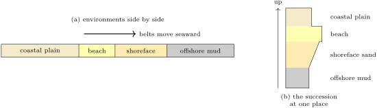
The law works both ways. A regression stacks the belts in their seaward order upward, a transgression in the reverse order; and a vertical succession read in a core gives the map of the neighbouring environments at the time. It fails exactly where Chapter 16 puts its key surfaces: across a sequence boundary, where exposure and erosion bring river sand onto shelf mud, and across a flooding surface, where offshore mud lies directly on the coastal plain.
17.2 Rivers
Definition 17.4 (Braided and meandering rivers)
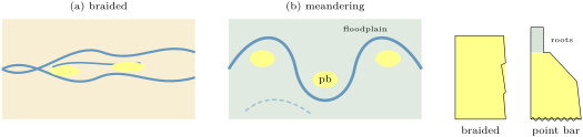
A braided river flows in several shallow channels that divide and rejoin around bars, on a steep plain with abundant coarse load and variable discharge. A meandering river flows in a single sinuous channel on a gentler plain, carrying more fine sediment; it migrates by eroding the outer bank of each bend and depositing on the inner one. The deposit on the inner bank is a point bar. Avulsion is the abandonment of a channel for a new course across the floodplain, usually after a flood breaches a levee.
A point bar grows sideways as the bend migrates, so at any place it records the cross-section of the channel from bottom to top: a lag of the coarsest clasts on an erosional base, cross-bedded sand from the dunes of the deep channel, finer sand with ripples from the shallow top of the bar, then the silt and mud of the floodplain with roots and soils. By Walther’s law this fining-upward succession, a few metres thick, has the thickness of the channel’s depth. A braided river leaves stacked sheets of cross-bedded sand and gravel with little mud, whose grain size hardly changes upward; its fines are carried away. Avulsion moves the channel belt across the plain, so that channel bodies stack at random among floodplain muds, separated by sharp erosional bases.
17.3 Shorelines, deltas and shelves
The deltas of the Year 1 volume, dominated by rivers, waves or tides, all build out by the same mechanism: the mouth deposits its load where the current slows, and the delta front progrades over its own prodelta muds. A prograding delta front or shoreface leaves, by Walther’s law, a coarsening-upward succession: offshore mud, interbedded mud and storm sand, shoreface sand, beach. Each parasequence of the previous chapter is one such succession.
Definition 17.5 (Shoreface and wave bases)
The shoreface is the sloping zone seaward of the beach where waves continually rework the sea floor. Its base is the fair-weather wave base, the depth below which ordinary waves no longer move the bottom sediment. The storm wave base is the deeper limit reached by storm waves; between the two, mud settles in calm weather and is reworked into sand beds during storms. Below the storm wave base the floor is undisturbed by waves.
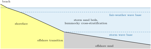
The orbital motion of a wave on deep water fades as with depth , for a wavelength : at half a wavelength it keeps of its surface amplitude, which sets the scale of a wave base. Buoy records of over two million wave spectra from the Caribbean, the Gulf of Mexico and the western Atlantic give modal wavelengths of about in the sheltered seas and about on the open margin, and show that, averaged over weeks to years, wavelengths do not split into a fair-weather class and a storm class: the chance that a wave stirs the bottom rises steadily as the water shallows. The two wave bases remain useful words for zones of a profile, not sharp depths.
Definition 17.6 (Hummocky cross-stratification)
Hummocky cross-stratification is a stratification of fine sand in gently curved laminae, concave-up (swales) and convex-up (hummocks), that cut one another at low angles and thicken and thin laterally, over wavelengths of a metre to several metres. It is formed by the oscillating and combined flows of storm waves, between the fair-weather and the storm wave base.
In the field — Storm beds on a Silurian shelf
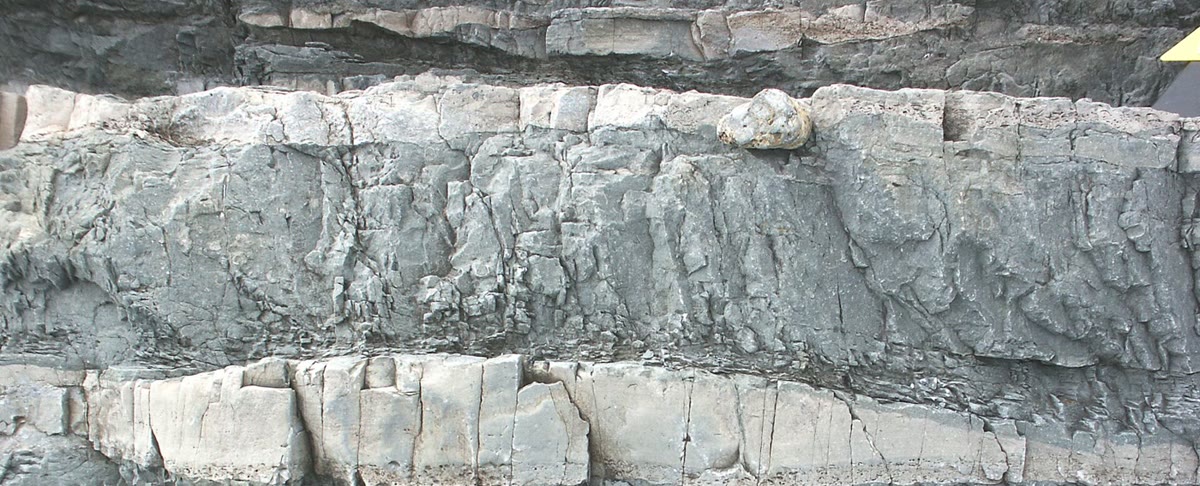
In the Arisaig Formation of Nova Scotia, layers of fine sandstone separate darker mudstone. Geologists who studied such beds recognise the low, curved, intersecting laminae of hummocky cross-stratification: each bed records a storm that stirred the shelf below the reach of everyday waves, and the mud around it the long calm between storms.
Where tides dominate, the facies change: flood and ebb currents build cross-beds that face in opposite directions, mud drapes settle at each slack water, and the thickness of the bundles between drapes waxes and wanes with the cycle of spring and neap tides. Tidal channels, flats and sand ridges have their own models, built the same way.
17.4 Deep water
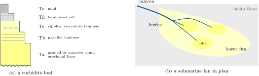
A turbidity current that slows deposits its load in the order of settling: the coarsest grains first, the finest last. A complete turbidite bed shows this order as five divisions.
Definition 17.7 (Bouma sequence)
The Bouma sequence is the ideal succession of divisions in a turbidite bed, from base to top: Ta, massive or graded sand on an erosional base with flute and tool marks; Tb, parallel-laminated sand; Tc, ripple cross-laminated and convolute fine sand; Td, parallel-laminated silt; Te, mud, partly from the turbidity current and partly from the slow settling between flows.
Few beds show all five: near the source the current is fast and leaves thick Ta divisions with the upper ones eroded by the next flow; far from it only the finer divisions, Tc to Te, arrive. The sequence thus records the waning of one flow, and the change of the beds along the fan the waning of the flows with distance.
Definition 17.8 (Submarine fan)
A submarine fan is a cone of sediment at the foot of a continental slope, fed by a canyon: an upper fan with a main channel between levées, a middle fan of distributary channels ending in sand lobes, and a lower fan of thin turbidites passing into basin-floor mud.
Along the margin, deep currents driven by the ocean’s circulation rework the fine sediment of the slope into contourites, mounds and drifts of bioturbated silt and mud that grow along the contours rather than down the slope.
17.5 Carbonate platforms
Carbonate sediment is made where it lies, by organisms in warm, clear, shallow water, and its facies follow the profile of the platform that the carbonate factory builds for itself.
Definition 17.9 (Carbonate ramp and rimmed shelf)
A carbonate ramp is a platform whose floor slopes gently and evenly from the shoreline into the basin, with no break: its facies belts, from tidal flats and beach-barrier sands to shoal grains, bioclastic sand and offshore lime mud, are wide and pass gradually into one another, sorted by the wave energy that decreases with depth. A rimmed shelf is a flat-topped platform with a marked break of slope at its margin, where reefs and sand shoals build a rim that shelters a lagoon behind it; beyond the rim a steep slope sheds blocks and grains into the basin.

On a flat platform top a small rise of relative sea level floods the tidal flats, and the factory, working fastest in the shallowest water, fills the space again up to sea level within a short time. The result is a stack of peritidal cycles a metre or a few metres thick, each a shallowing-upward parasequence from subtidal mud to a tidal flat with desiccation cracks or microbial mats, capped by the next flooding surface.
17.6 Cores and well logs
Most of the rock beneath sedimentary basins is known from boreholes. A few are cored, and their cores are described bed by bed like a cliff; nearly all are logged.
Definition 17.10 (Wireline logs)
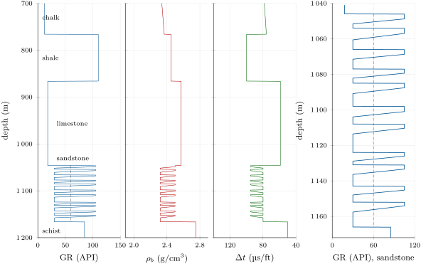
A wireline log is a continuous record of a physical property of the rocks against depth, measured by a probe lowered on a cable into a borehole. The gamma-ray log records the natural gamma radiation of the rock, in API units: high in shale, whose clays hold potassium, thorium and uranium, low in clean quartz sand and in limestone. The density log records the bulk density from the scattering of gamma rays emitted by a source on the probe. The sonic log records the interval transit time of a compressional wave, in microseconds per foot. The neutron log records the slowing of neutrons by hydrogen, and hence the water held in the pores and in clays.
The API gamma-ray unit is defined in a calibration pit: one two-hundredth of the difference between a zone of negligible radioactivity and a zone with the radioisotopes of an average shale at about twice its concentration. Coal, limestone and dolomite are usually less radioactive than shale; quartz sandstone is low, an arkose rich in potassium feldspar higher; any rock can be made radioactive by uranium carried in by ground water.
Proposition 17.11 (Porosity from density and transit time)
A rock of porosity , with grains of density and pores filled with a fluid of density , has the bulk density , so that
If a compressional wave crosses the grains and the fluid in series, in lengths proportional to and , its transit time is (the time-average equation), and .
Proof. A unit volume of rock holds a volume of grains and of fluid; its mass is , which is solved for . For the wave, a path of unit length crosses of grains and of fluid, and the times add. ∎
Grain densities are for quartz and for limestone; the pore water is when fresh and up to as brine. Transit times range from 42 to in dolomite, 48 to 53 in limestone, 53 for a consolidated sandstone, and 189 in brine. The density equation is exact for a known matrix; the time-average equation is an empirical rule that works best in consolidated rocks with intergranular pores. Shale breaks both: clays have their own densities and hold bound water.
Definition 17.12 (Net-to-gross ratio)
The net-to-gross ratio of an interval is the thickness of its reservoir-quality rock, usually sand picked on the gamma-ray log below a cutoff, divided by the total thickness of the interval.
The shape of the gamma-ray curve through a sand body is a facies tool. A bell, clean at the base and shalier upward, is a fining-upward succession, as in a point bar or a channel fill; a funnel, shaly at the base and clean at the top, a coarsening-upward succession, as in a prograding shoreface or delta front; a cylinder, clean throughout with sharp boundaries, a stacked braided-river sand, an aeolian dune or a carbonate shoal. The shapes are hints, not proofs: a core, or at least the neighbouring logs, must confirm them.
In the lab — Logging a core
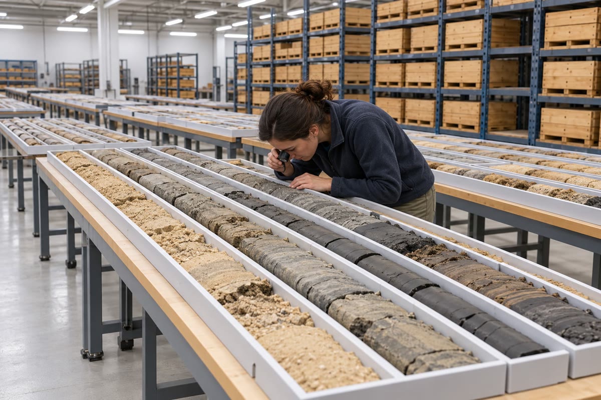
In a core store the cores of a well are laid out in trays, split lengthwise, in the order of their depth. A sedimentologist describes the core bed by bed on a log sheet: grain size with a hand lens and a comparison chart, structures, contacts, fossils, traces of burrows and roots, the colour of the mud. The description is then laid beside the wireline logs of the same depths, which calibrates the log shapes against the rock and lets the uncored wells nearby be read.
17.7 Exercises
Exercise 17.1 ★
A core shows, from the base up: offshore mud, interbedded mud and fine sand, shoreface sand, beach sand, then coal with roots. Using Walther’s law, give the order of the environments along the coast at the time and the direction in which the shoreline moved. What would a transgression have left?
Solution
Solution of Exercise 17.1.
From the sea to the land: offshore, offshore transition with storm sands, shoreface, beach, a coastal plain with swamps. Each environment came to lie over its seaward neighbour: the shoreline moved seaward, a regression. A transgression would have stacked them the other way, coastal plain at the base and offshore mud at the top, often with an erosion surface where the shoreface passed.
Exercise 17.2 ★
Three sand bodies show gamma-ray shapes: (a) a bell thick with a sharp base; (b) a funnel thick; (c) a cylinder thick with sharp top and base. Suggest an environment for each, and the observation in a core that would confirm it.
Solution
Solution of Exercise 17.2.
(a) A channel fill or point bar: a pebbly scour at the base, cross-beds, then ripples and rooted mud. (b) A prograding shoreface or delta front: mud with storm sand beds and hummocky cross-stratification below, cross-bedded shoreface sand and beach above. (c) Stacked braided-river sand, an aeolian dune or a carbonate shoal: cross-bed sets of constant grain size, with large dune foresets for the aeolian case or skeletal and oolitic grains for the shoal.
Exercise 17.3 ★
A sandstone reads . Compute its porosity with a quartz matrix and fresh water, then with brine of .
Solution
Solution of Exercise 17.3.
; with brine, .
Exercise 17.4 ★
Waves of modal wavelength and (the sheltered and the open seas of the buoy study). Estimate the depth at which each keeps of its surface motion, and the fraction left at a depth of .
Solution
Solution of Exercise 17.4.
at : about and . At : and of the surface motion.
Exercise 17.5 ★★
A limestone reads . Compute its porosity with the time-average equation for a matrix of 47.6 and of and brine at . What does the difference teach?
Solution
Solution of Exercise 17.5.
; . A matrix value uncertain by changes the porosity by a third: the time-average equation needs a matrix value checked on cores.
Exercise 17.6 ★★
A interval holds sand beds of 6.0, 3.5, 8.0 and below the cutoff, the rest mud. Compute its net-to-gross ratio. With a porosity of in the sand, how much pore volume does a square kilometre of the interval hold?
Solution
Solution of Exercise 17.6.
. Pore volume: per square kilometre.
Exercise 17.7 ★★
A turbidite bed near the mouth of a canyon is of massive sand (Ta) eroded at the top by the next bed; down the fan a bed of the same flow is of ripple-laminated fine sand and silt under of mud. Name the divisions of each and explain the change.
Solution
Solution of Exercise 17.7.
Near the canyon: Ta only, the upper divisions removed by the next flow; down the fan: Tc (ripples) and Td (silt) under Te (mud). The current loses speed and its coarse load with distance; only the fine fraction travels , and it is deposited by a slower flow that builds ripples, not by fallout from a dense suspension.
Exercise 17.8 ★★
A fining-upward succession thick has a sharp base with pebbles, cross-bedded sand, rippled fine sand and rooted mud. Interpret it, and estimate the depth of the channel that built it. Can Walther’s law be applied across its base? Why?
Solution
Solution of Exercise 17.8.
A point bar of a meandering river: lag on the scoured channel floor, cross-bedded sand of the deep channel, rippled sand of the top of the bar, floodplain mud with roots. The succession records the channel from floor to bank, so the channel was about deep (a little less, after compaction of the mud). Not across the base: it is an erosion surface, and what lay below may have been any older deposit.
Exercise 17.9 ★★
A platform floor drops over ; another keeps a depth of for , then drops over . Compute both gradients, name each platform and the facies expected at the edge of the second.
Solution
Solution of Exercise 17.9.
, : a ramp. , , after a flat top deep: a rimmed shelf, with reef or shoal grains at the margin and blocks and grain flows on the slope below.
Exercise 17.10 ★★★
A shoreline progrades at a speed while relative sea level rises at a rate , and its shoreface belt is wide. Show that the shoreface sand in the vertical succession is thick. Compute it for , and , and say what happens when . Compare with the proposition on the shoreline trajectory of Chapter 16.
Solution
Solution of Exercise 17.10.
The belt takes a time to pass a fixed place, during which the floor rises relative to sea level at under it: the sand fills . . With the shoreface leaves only the thickness of its own profile, a thin sheet, as the belts slide over one another without aggrading. The ratio is the tangent of the trajectory angle of the proposition of Chapter 16: the thickness of each facies is its width times that tangent.
Exercise 17.11 ★★★
A sandstone reads and . Compute its porosity from each log with a quartz sandstone matrix (2.65, ) and brine (1.0 for the density, ). If the sonic porosity is right, what grain density does the density log imply, and what may the cement be?
Solution
Solution of Exercise 17.11.
Density: ; sonic: . With , : denser than quartz, as for a sandstone cemented by calcite (2.71) or holding calcite grains.
Exercise 17.12 ★★★
In a core, black offshore mud rests directly on a coal with roots, with a thin layer of shell debris at the contact. Explain why Walther’s law does not apply across it, what surface it is, and how much of the coastal succession may be missing if waves eroded the floor down to a fair-weather wave base of about as the shoreline passed.
Solution
Solution of Exercise 17.12.
Offshore mud on a coal brings non-adjacent environments into contact: a flooding surface, here a transgressive surface of wave erosion, the shell debris a lag. As the shoreline moved landward, the waves cut the floor down to about the fair-weather wave base: the beach, the upper shoreface and the top of the coastal plain, up to about of section, may be missing.
17.8 Problem: Varden-2, a Well through the Cover
Problem 17.1
Weekend problem — the logs, porosity, facies and net sand of an invented well in the Varden syncline
The well Varden-2 is drilled in the syncline of the Varden Hills, at (7500, 7000) on the region’s grid, from a ground elevation of , to a total depth of . Its logs are drawn in the figure of the last section. Use grain densities of 2.65 (quartz) and (calcite), a pore water of , matrix transit times of 52.6 (sandstone) and (limestone), and for the water.
Part I — Reading the logs.
- The gamma ray jumps from 12 to at , falls to 18 at , becomes irregular from and steady at from . Name the units met, using their logs.
- Compute the thickness of each unit of the cover and the elevation of the base of the cover.
- The chalk reads near the surface and at . Compute its porosity at both depths. What happens to the chalk with depth?
- Why is the shale not given a porosity from its density?
- The schist reads and . What does the fast, dense, non-porous basement tell the driller?
Part II — Porosity.
- The limestone reads : compute its density porosity.
- It reads : compute its sonic porosity and compare.
- The clean sand of the channel fills reads : compute its porosity.
- Check it with its transit time, .
- If the pore water were a brine of , by how much would the density porosity of the sand change?
- Which unit would make the better aquifer or reservoir, and which the seal above it?
Part III — Facies. A core cut from 1108 to shows, from the base: a scoured surface with mud clasts and pebbles; of cross-bedded medium sand; of rippled fine sand passing into silt; of red-brown mud with root traces.
- Draw the gamma-ray shape expected through the cored interval.
- Name the succession and the environment of each part.
- With Walther’s law, describe the environments that lay side by side.
- Estimate the depth of the channel.
- The sandstone holds eleven such units, each on a sharp base. What does the stacking tell about the river and its plain?
- Can Walther’s law be used to go from one unit to the next? Why?
Part IV — Net sand. The eleven channel fills, from the base of the sandstone, are 14, 9, 12, 7, 16, 10, 13, 8, 11, 12 and thick. Each starts with clean sand () over a share of its thickness of 0.60, 0.45, 0.55, 0.30, 0.65, 0.40, 0.55, 0.35, 0.50, 0.45 and 0.30, then fines upward over a share of 0.25, 0.30, 0.25, 0.40, 0.20, 0.30, 0.25, 0.35, 0.25, 0.30 and 0.35, the gamma ray rising linearly to , and ends in mud.
- Which fraction of each fining interval lies below the cutoff?
- Compute the net sand of the lowest unit and of the thickest.
- Compute the clean-sand total and the fining-interval total of the sandstone.
- Compute its net-to-gross ratio.
- How would the net sand change with a cutoff of 45 or of ?
- With the sand porosity of question 8, compute the pore volume of the net sand under a square kilometre.
- State the net sand thickness of the Triassic sandstone at Varden-2.
Solution
Solution of Problem 17.1.
1. Chalk (cold, low density), shale from (hot), limestone from (cold, dense, fast), sandstone from (bell shapes), schist from .
2. Chalk , shale 100, limestone 180, sandstone ; base of the cover at .
3. near the surface, at : the chalk loses half its porosity under the weight of the overburden, by compaction.
4. Its grains are clays of uncertain density, and its water is partly bound to them: the equation’s assumptions fail.
5. Crystalline basement: the cover is crossed, and no reservoir is expected below.
6. .
7. : the same.
8. .
9. : the same.
10. , one point and a third more.
11. The sandstone, with porosity in its sands; the shale above the limestone seals it, and the floodplain muds divide the sandstone into compartments.
12. A bell: low gamma ray in the cross-bedded sand, rising through the fining interval to the high values of the rooted mud, on a sharp base.
13. A fining-upward succession: channel-floor lag on an erosional base, channel dunes (cross-beds), top of the point bar (ripples), floodplain (rooted mud).
14. The channel, its point bar on the inner bank, levées and a floodplain with soils, side by side.
15. About the thickness of sand and fining interval, , a little more before compaction.
16. A meandering river whose channel belt moved repeatedly by avulsion while the basin subsided, each new channel cutting into the floodplain left by the last.
17. No: each base is erosional; the floodplain mud below it and the channel sand above it need not have been neighbours.
18. .
19. Lowest: ; thickest: .
20. Clean sand ; fining intervals ; mud .
21. Net ; net-to-gross .
22. Fractions 0.20 and 0.60: and , a spread of from the choice of cutoff alone.
23. per square kilometre.
24. The net sand thickness of the Triassic sandstone at Varden-2 is .