University Earth and Space Sciences — Year 3 · Bachelor Year 3
21Ocean Dynamics
Through the Strait of Florida the Gulf Stream carries about of water northward, and it grows as it follows the coast north, to about near N. On the other side of the same ocean, off Portugal and north Africa, nothing like it flows south: the water that the Gulf Stream carries north returns towards the equator as a slow, broad drift across thousands of kilometres of open sea. Every ocean basin of the Northern Hemisphere has the same lopsided shape, its fast current on the western side. The asymmetry follows from the wind, from the friction of the sea, and from one fact about the Earth: the Coriolis parameter grows towards the pole.
You already know
The tidal force of the Moon and the Sun, spring and neap tides, are in the physics books. The wind stress, the Ekman layer, the Ekman transport and the Ekman spiral, upwelling and downwelling, the gyres, the western boundary currents, the sverdrup (), the meridional overturning circulation and the formation of deep water are in the Year 1 volume, in its chapter on the ocean circulation; there the wind stress is written , here . The Coriolis parameter, the -plane, the Rossby radius and the geostrophic balance are in Chapter 19; vorticity and potential vorticity in Chapter 20.
21.1 The Ekman layer derived
In the Year 1 volume the Ekman transport was found from a balance of forces on the whole layer, and the spiral of velocities inside it was stated. With a turbulent friction of constant eddy viscosity , the spiral follows from the equations in a few lines. Write the horizontal velocity as a complex number, , and the wind stress as ; a multiplication by turns a vector by clockwise, to its right seen from above.
Theorem 21.1 (Velocity profile of a steady wind-driven surface layer)
In a steady, horizontally uniform ocean of great depth and constant density , with a constant vertical eddy viscosity and the Coriolis parameter , the current driven by a wind stress is
for . The surface current is turned to the right of the stress; with depth it turns further right and decays as ; the total transport is at right angles to the right of the stress.
Proof. Away from coasts there is no horizontal pressure gradient in the layer, and the Coriolis force balances the friction: and , the primes being derivatives in . Multiplying the second by and adding gives . Its solutions are , since ; only the plus sign stays bounded as . At the surface the stress is carried by the friction, , so . As and , this is the stated . The factor turns clockwise as decreases. Finally . ∎
The theorem recovers both results of the Year 1 volume: Ekman’s surface current at and the transport , at right angles to the stress and independent of , which is never well known. At the depth the current flows against the surface current, reduced by , to .
Definition 21.2 (Ekman depth; Ekman pumping)
The Ekman depth is , the depth at which the current of the Ekman spiral flows opposite to the surface current; it measures the thickness of the Ekman layer. Ekman pumping is the vertical velocity at the base of the Ekman layer forced by the convergence or divergence of the Ekman transport: downward where the transports converge, upward, sometimes called Ekman suction, where they diverge.
Proposition 21.3 (Ekman pumping)
With the vertical velocity zero at the sea surface, the Ekman pumping is
upward positive.
Proof. The volume transport of the layer is , the theorem written in components. Integrating the continuity equation through the layer, , so . Expanding with gives the second form. ∎
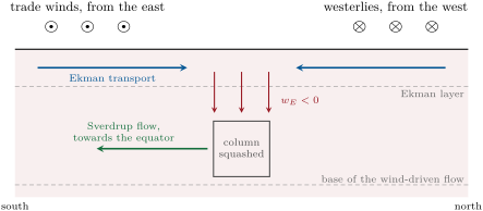
A wind that turns cyclonically over the sea, its curl positive, draws water up from below the layer; an anticyclonic wind pushes it down. Over the subtropical oceans the trade winds blow from the east on the equatorward side, the westerlies from the west on the poleward side. Their Ekman transports, north under the trades and south under the westerlies, converge between them: the surface water piles up and is pumped down, as in the figure below. Along a coast where the wind blows with the coast on its left (in the Northern Hemisphere), the transport leaves the shore and the coastal upwelling of the Year 1 volume is Ekman suction concentrated against a wall.
21.2 The Sverdrup balance
Below the Ekman layer the ocean is geostrophic. A column of water that is squashed by Ekman pumping must, to keep its potential vorticity , move to where is smaller: towards the equator. In 1947 H. U. Sverdrup made the argument quantitative for the whole depth of the wind-driven flow.
Theorem 21.4 (Sverdrup balance)
In a steady ocean in which the non-linear terms and the lateral friction are negligible, the interior is geostrophic below the Ekman layer, and the vertical velocity vanishes at some depth , the total northward volume transport per unit width of the wind-driven flow obeys the Sverdrup balance
Proof. In the geostrophic interior and . Hence , that is , and with continuity, . Integrating from , where , to the base of the Ekman layer, where , gives . By Proposition 21.3, . Adding the Ekman transport , multiplied by , cancels the last term: . ∎
The balance is remarkable for what it does not need: neither the depth of the flow, nor its vertical structure, nor the eddy viscosity, only the curl of the wind and . Sverdrup derived it from the equations of motion integrated down to a depth of no motion, and tested it against the hydrographic sections of the research vessels Carnegie and Bushnell in the eastern tropical Pacific, between N and S, with a depth of no motion at : the transports computed from the wind matched those computed from the density field, even where the currents ran against the wind. Later work with better winds found the best agreement with a depth of no motion near , and measurements of the mean stress in the equatorial Pacific in 1999 found the flow there in Sverdrup balance. Whether the balance holds everywhere is harder to show than to assume: almost every theory of the ocean circulation starts from it.
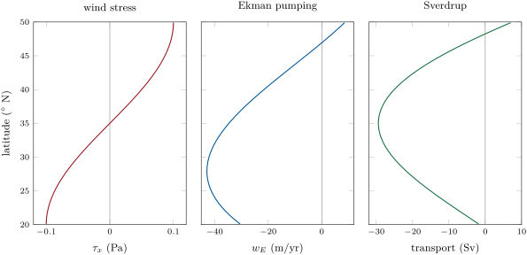
Take the invented basin of this chapter’s problem: between and N, wide, under a zonal stress with , easterly at N, westerly at N, zero at N. Over almost all the basin the stress curl is negative: the water is pumped down, by about a year at N, and the interior flows south, per metre of width at N, across the basin. Computed from the observed winds, the Sverdrup transport of the North Atlantic subtropical gyre reaches about near N.
The Sverdrup transport fixes at every point, but a streamfunction needs a boundary condition, and a meridional wall can take only one. If the interior satisfies no flow through the eastern wall, the southward flow has nowhere to go at the western wall; the mass is returned by a current that Sverdrup’s equations, without friction, cannot describe.
21.3 Western intensification
In 1948 H. Stommel added the simplest friction to the simplest ocean, and found the return flow crowded against the western wall, as in the Year 1 volume’s figure of his gyre. He found it only with a Coriolis parameter that grows northward: with no rotation, or with a uniform one, his gyre was symmetric.
Definition 21.5 (Western intensification; Stommel model; Munk boundary layer)
Western intensification is the crowding of the return flow of a wind-driven gyre into a narrow, fast current against the western side of the basin. The Stommel model is a homogeneous ocean of constant depth in a rectangular basin, driven by a zonal wind stress and slowed by a bottom friction proportional to the depth-integrated velocity, with a rate ; its transport streamfunction (, ) obeys
The Munk boundary layer is the western boundary layer of the same gyre when a lateral eddy viscosity replaces the bottom friction; its width scale is .
The equation is the Sverdrup balance with the curl of the bottom friction added: integrated over the depth, , where is the vorticity of the transport.
Theorem 21.6 (Western boundary layer of the Stommel gyre)
In a basin , , with and , the Stommel streamfunction is, to leading order in ,
The interior carries south; a boundary layer of width against the western wall returns it north; no boundary layer can exist against the eastern wall.
Proof. The stress curl is . Over the width of the basin the friction term is smaller than the term by ; dropping it leaves the Sverdrup balance, , whose solution vanishing at is . It does not vanish at . Near a wall varies fast in , and the equation reduces to for the correction, whose solutions are a constant and . This one decays eastward, away from the western wall: adding makes at and changes nothing in the interior. At the eastern wall a correction would have to decay westward, away from , and grows westward: there is no such layer, so the interior must meet the eastern wall by itself, as does. The northward transport between the wall and the point where changes sign is there, close to . ∎
The same answer comes from vorticity. Over the interior the wind gives each column negative vorticity, and the column pays for it by moving south, to smaller . On the way back north it gains planetary vorticity and must lose it, which only friction can do. In a northward current whose speed falls off eastward from near the western wall, over most of its width: the current’s vorticity is negative, and friction, acting against it, supplies the positive vorticity that the columns need. A northward current against an eastern wall would have positive vorticity, and friction would take away the wrong sign.
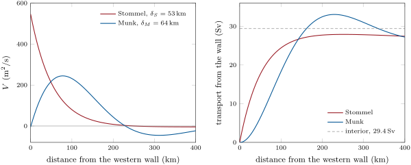
With at N, , and the northward flow occupies the first from the wall. In 1950 W. H. Munk replaced the bottom friction by a lateral eddy viscosity , which acts on the shear within the current; the equation gains a term , and near the western wall the correction becomes times an oscillation, and . With the northward jet is about wide ( in the basin of the figure), with a weak countercurrent beyond it, a shape close to the Gulf Stream and the Kuroshio. As in Stommel’s layer, the transport of the jet does not depend on the friction but only on the wind-stress curl, the width of the basin and . From the winds of his time Munk computed for the Gulf Stream and for the Kuroshio, about half the transports then measured; with a better drag coefficient and finer averages of the stress, was found for the Gulf Stream in 1978. Measured mainly with a submarine cable, the Gulf Stream in the Strait of Florida has carried on average since 2004. Downstream it grows to about near N, and offshore of Cape Hatteras a strong recirculation, which the linear theory does not contain, spoils the agreement.
21.4 The abyssal circulation
The deep ocean is filled from a few places. In the Year 1 volume, deep water forms where surface water is cooled and made dense in the far North Atlantic and round Antarctica, and spreads through the basins as North Atlantic Deep Water and Antarctic Bottom Water. Between 1958 and 1960 H. Stommel, A. B. Arons and A. J. Faller asked how it spreads, using the same vorticity argument as Sverdrup.
Definition 21.7 (Stommel–Arons model)
The Stommel–Arons model of the abyssal circulation supposes that deep water is supplied by convection at a few high-latitude sources, that it returns to the upper ocean by a slow, uniform upwelling through the base of the thermocline, balanced by downward mixing of heat, and that the interior flow is geostrophic and conserves potential vorticity. The circulation is closed by deep western boundary currents.
Proposition 21.8 (Poleward interior flow of the abyss)
In the Stommel–Arons model, over a flat bottom, the depth-integrated northward transport of the abyssal interior is
poleward in both hemispheres when .
Proof. In the geostrophic interior , as in the proof of the Sverdrup balance. Integrating from the flat bottom, where , to the top of the abyssal layer, where , gives , and . In the Southern Hemisphere : the flow is southward, again poleward. ∎
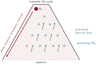
The result is counter-intuitive: the abyssal interior flows towards the sources, not away from them. Stommel and Arons built rotating-tank experiments to convince themselves. The water from the sources travels along the western walls, in deep western boundary currents that feed the interior as they go. In a sector of ocean between the equator and the pole with the whole source near the pole, the western boundary current carries towards the equator, twice the source at the pole and nothing at the equator: the excess over is water recirculating from the interior. The model makes the deep circulation driven by mixing, not by sinking: without the upwelling, convection would only fill the abyss with a stagnant pool of cold water. Its transit times range from a few centuries near the sources to nearly a thousand years in the North Pacific. Over the real ocean floor the ridges divide the basins, mixing is strong over rough topography, and the deep flow is far more zonal than the model’s. Its lasting prediction is the deep western boundary current: in the North Atlantic one returns about of water at to the south, while the Gulf Stream carries the warm water north.
The interior of the model, like Sverdrup’s, is geostrophic, and the geostrophic currents of the deep sea are measured in the way that Sverdrup measured his: from the density.
Definition 21.9 (Dynamic method)
The dynamic method computes the geostrophic current between two hydrographic stations from the density measured at both, relative to a reference pressure level where the current is taken to be zero or known. The geopotential distance between two pressure surfaces, with the specific volume, is split into a standard part, the same at both stations, and the geopotential anomaly ; the current at the upper surface, at right angles to the line between stations and , a distance apart, is
Why not measure the pressure directly, as meteorologists do? A geostrophic current of at needs a pressure gradient of , across : the weight of of sea water. No pressure gauge on the sea floor can be levelled that well. The density, computed to a few parts per million, gives instead the slope of one pressure surface relative to another. The lighter, warmer water lies to the right of the current, looking downstream, in the Northern Hemisphere. Across the Gulf Stream the surfaces of constant density change depth by more than a kilometre over .
Method 21.10 (Geostrophic current from two stations)
- At each station, compute the specific-volume anomaly from the measured salinity, temperature and pressure.
- Integrate it from the reference pressure up to each pressure : .
- At each pressure, is the current relative to the reference level, positive with station on the right.
- Add the current at the reference level if it is known, from a float drifting there or from the sea-surface slope measured by satellite.
In the field — An array of floats
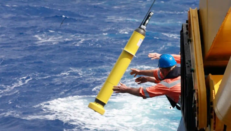
Figures as of 2024
Close to four thousand Argo floats drift through the world ocean. Lowered over the side of a ship, a float sinks to about and drifts there for about nine days; it then sinks to and rises to the surface, measuring conductivity, temperature and pressure on the way, and the cycle starts again about every ten days; Deep Argo floats profile to . In July 2024 the array collected its three millionth profile. From the profiles oceanographers compute the geopotential anomalies of the dynamic method at every float, and the float’s own displacement between two surfacings gives the mean current at its parking depth: the reference velocity that Sverdrup had to assume is now measured.
21.5 Ocean tides
Twice a day, a little less than an hour later each day, the sea rises and falls. The physics books explain the tidal force: the Moon’s attraction is stronger on the near side of the Earth than at its centre, and weaker on the far side, so that relative to the centre the water is pulled out along the line to the Moon on both sides.
Definition 21.11 (Equilibrium tide; tidal constituent)
The equilibrium tide is the shape that the surface of an ocean covering the whole Earth would take if it followed the tide-generating potential instantly, without inertia. A tidal constituent is one of the harmonic terms, each with a fixed frequency set by the motions of the Moon and the Sun and an amplitude and phase found at each place, whose sum makes the tide; they are named by a letter and the number of cycles per day, such as M, the principal lunar semi-diurnal constituent.
Theorem 21.12 (Equilibrium tide of the Moon)
For the Moon, of mass at distance from the centre of the Earth, of mass and radius , the equilibrium tide at an angle from the point under the Moon is
Proof. The potential of the Moon at a point at distance from the Earth’s centre and angle is , with . Expanding in , . The first term is a constant; the second is a uniform field, the one that accelerates the whole Earth in its orbit round the common centre of mass, and has no effect relative to the Earth. What is left is the tide-generating potential . In equilibrium the sea surface is a surface of constant total potential, , with , so . The mean of over the sphere is zero; the volume of water being fixed, . ∎
With the mass ratio , and , : the sea stands high under the Moon and on the opposite side, and low on the great circle between, a range of . At latitude , with the Moon at declination and at hour angle , . As the Earth turns under the two bulges a place passes through two high waters a lunar day, : the semi-diurnal tide. When the Moon stands north or south of the equator the two bulges are tilted, and the two high waters of a day are unequal, as the figure below shows. The Sun raises a tide of the same form, times as large; the two add at new and full moon, at spring tides, and partly cancel at the quarters.
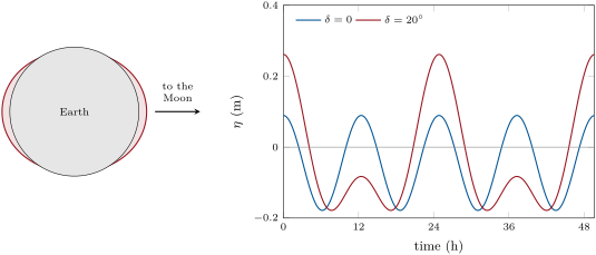
The harmonic analysis of the equilibrium tide gives its constituents. The five largest, with their equilibrium amplitudes, are in the table below. At least 39 constituents are needed to predict a port’s tide to a thousandth of its largest term, and a gauge must run for more than 18.6 years, the period of the modulation of the lunar tides, to separate them all.
| constituent | origin | period () | equilibrium amplitude () |
|---|---|---|---|
| M | principal lunar, semi-diurnal | ||
| S | principal solar, semi-diurnal | ||
| N | lunar elliptic, semi-diurnal | ||
| K | luni-solar, diurnal | ||
| O | principal lunar, diurnal |
The real tide is not the equilibrium tide. To keep a bulge under the Moon on the equator, the tide would have to travel round the Earth in a lunar day, at about , a speed that a long gravity wave reaches only in an ocean deep; and the continents stop it. The tide is instead a forced long wave, sloshing in each basin near resonance, and the rotation of the Earth makes it turn round the basin.
Definition 21.13 (Kelvin wave)
An oceanic Kelvin wave is a long gravity wave that travels along a coast, or along the equator, with no velocity across it, its height decreasing exponentially away from the coast over the Rossby radius. Along a coast it travels with the coast on its right in the Northern Hemisphere, on its left in the Southern.
Theorem 21.14 (Coastal Kelvin wave)
In an ocean of uniform depth on an -plane, with , bounded by a straight coast along and lying in , the linear shallow-water equations have the solutions with
for any profile , and no solution with travels in the direction .
Proof. With the equations are , and . The first and the third give : in each line const carries waves with , and then the first equation gives . The second becomes , so . With the upper sign the wave decays away from the coast; with the lower one it would grow without bound into the ocean, which is excluded. The wave goes towards with the ocean on its left, the coast on its right. ∎
Over the deep ocean, deep, and the Rossby radius is about at mid-latitudes: the tide sweeps round a whole basin. Over a shelf sea deep, , the Rossby radius is under , and an M wavelength is about . In a gulf, the tide entering along one coast as a Kelvin wave returns along the opposite coast, again with the coast on its right; the two waves cancel at points in between.
Definition 21.15 (Amphidromic point; cotidal line; co-range line)
An amphidromic point is a point where the amplitude of a tidal constituent is zero and round which its high water turns. A cotidal line joins the places where a constituent’s high water comes at the same time; a co-range line joins the places of equal tidal range. Cotidal lines radiate from the amphidromic points; co-range lines circle them.
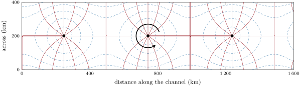
The maps of the ocean tide made from satellite altimetry, accurate to about in the deep sea, show this structure everywhere: the M crest turns anticlockwise round the amphidromes of the Northern Hemisphere basins and clockwise in the Southern, and the largest ranges are on the coasts. The tides dissipate , of it in the ocean, about two thirds of the M energy on the shelves and in shallow seas and one third through internal waves in the deep ocean. That energy lengthens the day by about a century and pushes the Moon away by a year; and the part lost in the deep ocean mixes it, supplying some of the mixing that, in the Stommel–Arons picture, drives the abyssal circulation.
21.6 Exercises
Exercise 21.1 ★
A westerly wind stress of blows over the sea at N (, ). Compute the Ekman volume transport per metre of width and its direction, and the transport across a section long, in sverdrups.
Solution
Solution of Exercise 21.1.
; , to the right of the wind: south. Across , , .
Exercise 21.2 ★
With , compute the Ekman depth at N. What fraction of the surface current remains at that depth?
Solution
Solution of Exercise 21.2.
; . The current there is of the surface current, flowing the opposite way.
Exercise 21.3 ★
At N the curl of the wind stress is across a basin wide (). Compute , the Sverdrup transport per unit width and the total transport, with its direction.
Solution
Solution of Exercise 21.3.
; ; across , : southward.
Exercise 21.4 ★
From the periods of M and S, compute the period of the cycle of spring and neap tides, the time between two alignments of the two constituents.
Solution
Solution of Exercise 21.4.
The two constituents come back into phase after , days, half a synodic month.
Exercise 21.5 ★★
A westerly stress grows linearly from 0 at N to at N, further north. Compute the Ekman pumping at N, keeping both terms of Proposition 21.3, in metres per year. Is the water pushed up or down?
Solution
Solution of Exercise 21.5.
At N, , , and . The first term, ; the second, . , : the water is pushed down.
Exercise 21.6 ★★
In a Stommel gyre with and , compute the width . If the boundary current carries in the upper , within a width , what is its mean speed?
Solution
Solution of Exercise 21.6.
; speed .
Exercise 21.7 ★★
Compute the Munk width and the width of the northward jet, , at N for . How does the width change if is eight times smaller?
Solution
Solution of Exercise 21.7.
; , and the jet is wide. With eight times smaller both are halved, since .
Exercise 21.8 ★★
Two stations apart lie on a line from west () to east () at N. Relative to the surface, the geopotential anomaly of the sea surface is at and at . Compute the surface current relative to and its direction. Which station has the warmer water column?
Solution
Solution of Exercise 21.8.
; , positive with on the right: looking from to , east, the current goes north. The sea surface stands higher at ; the water column at is the lighter, warmer one, on the right of the current.
Exercise 21.9 ★★
With the equilibrium tide of the Moon, , and the ratio of the solar to the lunar tide, compute the equilibrium range (high water under the bodies minus low water at ) at spring and at neap tides, and their ratio.
Solution
Solution of Exercise 21.9.
Spring range ; neap range ; ratio .
Exercise 21.10 ★★★
On the equatorial -plane, with . Show that the Kelvin wave , , becomes , trapped on both sides of the equator, and travels east. Compute its trapping scale for a wave of speed .
Solution
Solution of Exercise 21.10.
As in Theorem 21.14, for , and becomes , so . Only the upper sign, the eastward wave, is bounded on both sides of the equator. , .
Exercise 21.11 ★★★
(a) Derive for the abyssal interior from . (b) With , compute at N and the total poleward transport across a basin wide. (c) Where must the water come from?
Solution
Solution of Exercise 21.11.
(a) Integrating from the bottom, , to the top of the abyssal layer, : , and . (b) , across , poleward. (c) From a deep western boundary current fed by the high-latitude sources; the interior flows towards the sources, the boundary current away from them.
Exercise 21.12 ★★★
A geostrophic current flows over a flat sea floor at , with eddy viscosity and no slip at the floor. (a) Show that , . (b) Show that the transport defect of this bottom Ekman layer pumps the vertical velocity into the interior, the vorticity of the geostrophic current. (c) For , and an ocean deep, compute , the spin-down rate , and its inverse in days.
Solution
Solution of Exercise 21.12.
(a) With upward from the floor, , the pressure gradient being that of the geostrophic flow above. is bounded upward, and gives . (b) The transport defect is , that is . The geostrophic flow being non-divergent, . (c) ; , a spin-down time of days.
21.7 Problem: A Gyre in the Sea of Ammar
Problem 21.1
Weekend problem — Ekman pumping, Sverdrup transport, the western boundary current and the tide of an invented ocean
The Sea of Ammar is an invented ocean basin, a rectangle from to N and wide, deep. The wind stress is zonal, with . Take , , , , and, where a -plane is asked for, its value at N.
Part I — The Ekman layer.
- Compute the wind stress at , and N.
- Compute at the same latitudes.
- Compute the Ekman volume transport per unit width at and N, with its direction. Do the transports converge or diverge in the basin?
- With , compute the Ekman depth at N.
- Compute the Ekman pumping at N, in metres per second and per year.
- How many years would it take this pumping to push the surface water down ?
Part II — The Sverdrup interior.
- Compute the length of the basin from south to north and at N.
- Compute the curl of the wind stress at N.
- Compute the Sverdrup transport per unit width at N, with its direction.
- Compute the total interior transport across the basin at N, in sverdrups.
- If this flow is spread through the upper , what is its mean speed, and how many years does a parcel take to move south?
- Show that at N gives the same transport, and explain why with the potential vorticity of a column.
Part III — The western boundary current.
- Explain why the return flow cannot run along the eastern side of the basin.
- With a bottom friction , compute the Stommel width .
- Compute the northward transport per unit width at the western wall, , and the mean speed if it fills the upper .
- How far from the wall does the northward flow end?
- Compute the northward transport of the Stommel boundary layer, and explain why it falls short of the interior transport by about .
- With , compute and the width of Munk’s northward jet.
- Munk’s jet carries times the interior transport. Compute it, and say where the excess goes.
Part IV — The tide of the Sea of Ammar.
- Compute the speed of a Kelvin wave in the basin and the Rossby radius at N.
- Compute the wavelength of the M Kelvin wave.
- How long does a Kelvin wave take to travel once round the coasts of the basin, and how many M periods is that?
- At what speed would the equilibrium tide have to travel round the N circle to stay under the Moon, and in what depth of ocean would a long wave go that fast?
- Where would you expect the amphidromic point of the basin, and which way does high water turn round it?
- Compute the semi-diurnal equilibrium amplitude at N, , with , for the Moon on the equator.
- Give the transport of the western boundary current that closes the gyre of the Sea of Ammar.
Solution
Solution of Problem 21.1.
1. (easterly), 0 and (westerly).
2. , and .
3. : (north) at N and (south) at N. They converge.
4. .
5. at N, so , , downward.
6. .
7. ; .
8. .
9. , southward.
10. , southward.
11. ; in , years.
12. : the same, because the Ekman transport vanishes where . A column squashed at the rate keeps its potential vorticity only by moving to smaller , south, at the rate .
13. A boundary layer can only be one in which the correction to the interior decays away from the wall; with that is , which decays eastward, from the western wall only. In vorticity terms, friction in a northward current against an eastern wall would remove positive vorticity, the wrong sign.
14. .
15. , : , through .
16. Where : .
17. . The interior flow is still going south in the strip next to the wall; the shortfall, , is the interior transport that would have crossed that strip.
18. ; jet .
19. ; the excess, of the interior transport, returns south in the countercurrent just east of the jet.
20. ; .
21. .
22. Perimeter , , 2.1 M periods.
23. The circle is , covered in a lunar day, : , which needs of water.
24. With a Rossby radius comparable to the width of the basin and the M wavelength comparable to its length, about one amphidromic point, near the centre of the basin; the high water turns anticlockwise round it, keeping the coast on its right.
25. .
26. The western boundary current returns north the that the interior carries south ( by the calculation).