Primary & Middle School Earth and Space Sciences · Grades 1–9
18Plate Tectonics: The Moving Puzzle
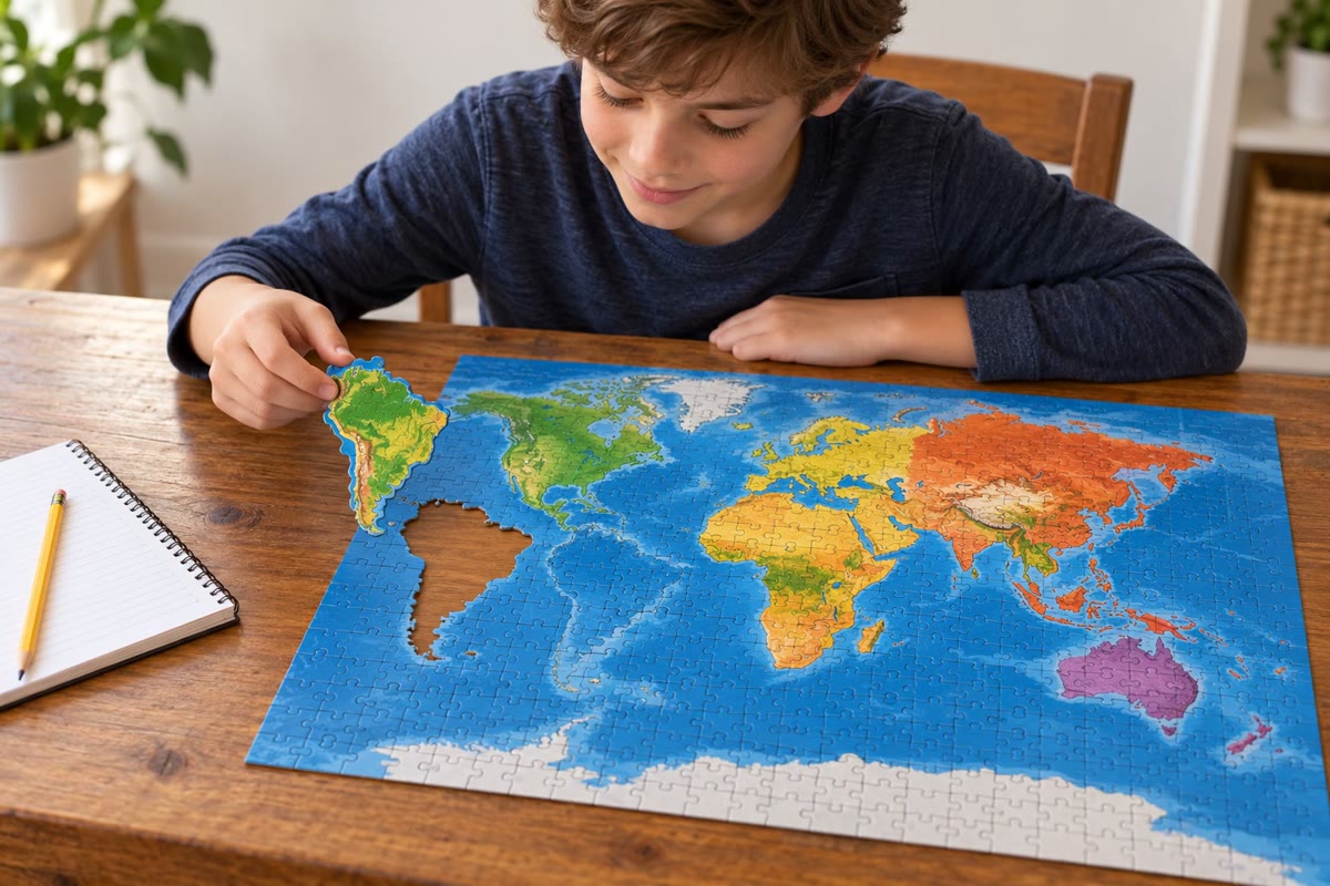
Spread a map of the world on a table and look at the two shores of the Atlantic Ocean. The great bulge of Brazil seems made to slide into the hollow of Africa’s west coast, as if someone had cut a single piece of land in two and pushed the halves apart. The first people to print good maps of both coasts noticed it at once. For three centuries it remained a curiosity. In the twentieth century it became the starting point of the theory that now explains why the ground shakes in Japan, why the Andes are so high, why Iceland is slowly growing wider — and why the map on the table is only a snapshot of a world that is moving.
You already know
The Earth has three main layers: a thin, rocky crust, a thick mantle of hot rock, and a metallic core; temperature rises with depth (Chapter 16). A place on the globe is located by its latitude and its longitude (Chapter 14).
18.1 Continents that once fitted together
Definition 18.1 (Continental drift)
Continental drift is the idea that the continents move slowly across the surface of the Earth, so that their positions, and the shapes of the oceans between them, have changed over the ages.
Definition 18.2 (Supercontinent)
A supercontinent is a single landmass made of all, or almost all, of the continents joined together. The last one, Pangaea (“all lands” in Greek), began to break up between about 225 and 200 million years ago.
The scientist who defended continental drift as a real theory, with evidence, was Alfred Wegener. He gathered four kinds of clues.
- The shapes of the coasts. South America and Africa fit together like two pieces of a jigsaw, and so do several other coastlines.
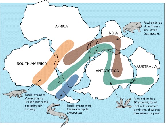
- Fossils. The same fossil animals and plants are found on continents that are now separated by thousands of kilometres of ocean. Mesosaurus was a small reptile that lived in fresh water: it could not have swum across an ocean, yet its fossils lie both in Brazil and in southern Africa.
- Rocks. Rocks of the same kinds and ages, and old mountain chains of the same shape, stop at one coast and start again on the opposite one, as the lines of print on a torn newspaper do.
- Ancient climates. Coal, made from the plants of warm, swampy forests, is found in Antarctica; traces left by ancient glaciers are found in parts of Africa that are now hot and dry. These lands must once have lain in other climates, at other latitudes.
History — Wegener’s idea, 1912–1930
Alfred Wegener, a 32-year-old German meteorologist, set out the theory of continental drift in two articles in 1912. Most geologists rejected it. The strongest objection was that Wegener could not say what moved the continents: he thought they ploughed through the rock of the ocean floor, and the physicist Harold Jeffreys showed that solid continents could not do that without breaking up. Wegener went on collecting evidence until he died on the Greenland ice cap in 1930, during an expedition. The answer he lacked came from the floor of the oceans, explored after the 1950s: it is told in a later year.
18.2 The plates
Wegener’s clues were right, but his continents were the wrong pieces. It is not only the continents that move: the whole outer shell of the Earth, under the continents and under the oceans alike, is broken into pieces.
Definition 18.3 (Tectonic plate)
A tectonic plate (or simply a plate) is a large, rigid slab of rock that forms part of the Earth’s outer shell. A plate is made of the crust and of the uppermost, cold and rigid part of the mantle, together at least 80 kilometres thick on average; it moves slowly over the hotter and softer mantle beneath it.
Definition 18.4 (Plate tectonics)
Plate tectonics is the theory that the outer shell of the Earth is divided into plates that move relative to one another, and that most earthquakes, volcanoes and mountain ranges are produced where plates meet.
Remark 18.5 (How many plates?)
About a dozen plates are large; many more are small. A detailed map used by geologists counts 52 of them. A plate may carry a continent, an ocean, or both: the South American plate carries the whole of South America and the western half of the South Atlantic Ocean. The Pacific plate, the largest, carries almost no land at all.
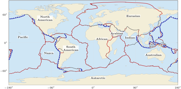
How do we know where one plate ends and the next begins? Look at where the Earth is restless.
Proposition 18.6 (Earthquakes and volcanoes trace the plate boundaries)
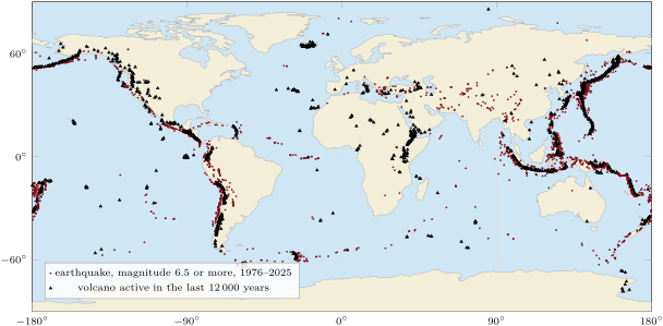
Earthquakes and volcanoes are not scattered at random over the Earth: most of them lie along narrow belts, and these belts are the edges of the plates. Of the 7 031 earthquakes of magnitude 6 or more recorded between 1976 and 2025, 6 472 — that is 92 % — happened less than from a plate boundary.
18.3 Three kinds of plate boundaries
Definition 18.7 (Plate boundary)
A plate boundary is the line, or the narrow zone, where two plates meet. According to how the two plates move with respect to each other, a boundary is of one of three kinds:
Example 18.8 (Divergent boundaries: Iceland and East Africa)
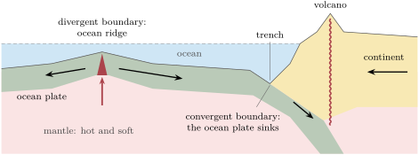
Down the middle of the Atlantic Ocean runs a chain of undersea mountains, the Mid-Atlantic Ridge, where the plates on either side move apart. Hot rock from the mantle rises into the gap, melts in part, and becomes new sea floor: a divergent boundary builds new plate. Iceland is a piece of this ridge that rises above the sea: there, North America moves westward and Eurasia eastward, and the island is slowly torn open. Between 1975 and 1984, the cracks near the Krafla volcano, in the north of the island, widened by about 7 metres in all. A divergent boundary can also cut through a continent: along the East African Rift, Africa is beginning to split, and the Red Sea is a young ocean that has already separated Arabia from Africa.
Example 18.9 (Convergent boundaries: the Andes and the Himalaya)
Off the west coast of South America, the Nazca plate, which carries ocean, moves towards the South American plate, which carries a continent. The ocean plate, heavier, bends and sinks beneath the continent, deep into the mantle. Along the line where it goes down, the sea floor plunges into a deep trench; above the sinking plate, the land is shaken by earthquakes and lined with volcanoes: the Andes. In the western Pacific, where one ocean plate sinks under another, the trenches are the deepest places on Earth: the Mariana Trench is nearly deep. When two continents meet, neither sinks: the crust crumples and thickens. India collided with Asia about 50 million years ago, and the two plates are still pushing; that is how the Himalaya and the Tibetan Plateau were raised.
Example 18.10 (A transform boundary: the San Andreas fault)
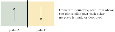
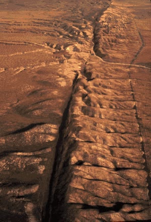
In California, the Pacific plate slides north-westwards past the North American plate along the San Andreas fault, about long. No plate is made or destroyed there; the two plates grind past each other, and the jolts of that grinding are earthquakes.
Method 18.11 (Recognising a plate boundary on a map)
To decide what kind of boundary separates two plates:
- find, on a map of plate motions, the arrows on either side of the boundary;
- if they point away from the boundary, it is divergent; if they point towards it, convergent; if they are parallel to it and point in opposite directions, transform;
- check with the landscape: a ridge in the middle of an ocean or a rift across a continent goes with a divergent boundary; a deep trench with a line of volcanoes, or a high mountain range, with a convergent one; a long straight fault with neither, with a transform boundary.
18.4 How fast do plates move?
Proposition 18.12 (A few centimetres a year)
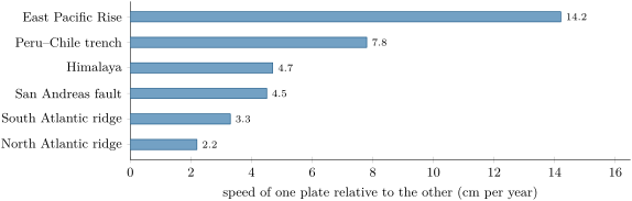
Two neighbouring plates move relative to each other at a speed of a few centimetres per year: from about 2 centimetres per year across the North Atlantic to more than 14 centimetres per year across the East Pacific Rise, the fastest-spreading ridge on Earth.
Method 18.13 (From centimetres per year to kilometres per million years)
A kilometre is centimetres. A speed of per year, kept up for a million years, therefore covers centimetres, that is . Hence:
Multiply a speed in centimetres per year by 10 to get kilometres per million years; then multiply by a number of millions of years to get a distance in kilometres, or divide a distance by the speed to get a time.
Example 18.14 (The Atlantic grows)
On average, the two sides of the Mid-Atlantic Ridge move apart at about per year, that is per million years. In 100 million years that makes : kept up long enough, a speed far too slow to notice in a lifetime opens an ocean.
Remark 18.15 (Measuring the motion today)
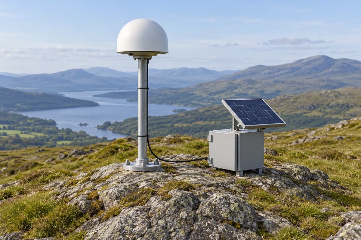
Such slow motions are now measured directly. Permanent stations fixed to the bedrock receive the signals of positioning satellites and work out their own position, day after day, to a few millimetres. Over a few years, stations on different plates are seen to move apart or closer together, at the speeds found from the rocks over millions of years. Satellite positioning itself is the subject of Chapter 32.
18.5 Exercises
Exercise 18.1 ★
What is continental drift? Give the four kinds of clues Wegener used to defend it.
Solution
Solution of Exercise 18.1.
Continental drift is the idea that the continents move slowly across the Earth’s surface, so that their positions have changed over the ages. Wegener’s clues: the fit of the coastlines (South America and Africa); the same fossils on continents now separated by oceans; the same rocks and old mountain chains on either side of an ocean; traces of ancient climates out of place (coal in Antarctica, glacial deposits in hot, dry Africa).
Exercise 18.2 ★
Name the three kinds of plate boundary and say, for each, how the two plates move with respect to each other.
Solution
Solution of Exercise 18.2.
Divergent: the plates move apart. Convergent: they move towards each other. Transform: they slide past each other, side by side.
Exercise 18.3 ★
Look at the map of earthquakes and volcanoes. Name two regions of the world with many large earthquakes, and one continent that has almost none in its middle.
Solution
Solution of Exercise 18.3.
For example, all around the Pacific Ocean (Japan, Indonesia, the Andes), and the belt running from the Mediterranean to the Himalaya. Almost no large earthquakes in the middle of Africa or of Australia (also of North America east of the Rocky Mountains, or of Brazil).
Exercise 18.4 ★
Fossils of Mesosaurus, a small reptile that lived in fresh water, are found in Brazil and in southern Africa. Why is this a clue that the two continents were once joined?
Solution
Solution of Exercise 18.4.
An animal of fresh water could not cross thousands of kilometres of salt ocean. Finding it on both sides means that the two places were once joined by land, in one continent, when Mesosaurus lived.
Exercise 18.5 ★★
Coal is found in Antarctica. What does this tell us about the climate in which the coal formed, and what can we conclude about where Antarctica was at that time?
Solution
Solution of Exercise 18.5.
Coal forms from the plants of warm, wet, swampy forests: the climate was warm and humid. Such forests cannot grow near the South Pole today, so Antarctica must once have been much closer to the equator: it has moved.
Exercise 18.6 ★★
Say which kind of boundary is found at each of these places: the Mid-Atlantic Ridge; the Andes; the San Andreas fault; the Himalaya; the East African Rift.
Solution
Solution of Exercise 18.6.
Mid-Atlantic Ridge: divergent. Andes: convergent (an ocean plate sinks under a continent). San Andreas fault: transform. Himalaya: convergent (two continents collide). East African Rift: divergent (a continent splitting).
Exercise 18.7 ★★
Convert a speed of per year into kilometres per million years. How far apart would two points on either side of the boundary move in 60 million years at this speed?
Solution
Solution of Exercise 18.7.
kilometres per million years; in 60 million years: .
Exercise 18.8 ★★
Between 1975 and 1984 — nine years — the cracks near the Krafla volcano in Iceland widened by about in all. What was the average widening per year, in centimetres? Compare it with the average speed of the Mid-Atlantic Ridge, about per year, and suggest why the two numbers are so different.
Solution
Solution of Exercise 18.8.
, and : about per year, some 30 times the average of per year. The plates do not slide apart smoothly at the surface: the strain builds up for years and is released in short bursts, when the cracks open by metres at once. Over long periods, quiet years and bursts average out to a few centimetres per year.
Exercise 18.9 ★★
Wegener’s theory was rejected for decades. What question could he not answer? What does the theory of plate tectonics change in his picture of moving continents?
Solution
Solution of Exercise 18.9.
He could not say what force moves the continents, and the motion he imagined (continents ploughing through the ocean floor) was impossible. In plate tectonics, the continents do not plough through anything: they are carried, with the ocean floor around them, by plates that move as whole pieces of the Earth’s outer shell.
Exercise 18.10 ★★
Look at the cut through two plate boundaries. Where is the sea floor highest, and where is it deepest? Where is new plate being made, and where does a plate go back into the mantle?
Exercise 18.11 ★★★
Across the East Pacific Rise the plates move apart at about per year, and across the North Atlantic ridge at about per year. How many times faster is the East Pacific Rise (round to the nearest whole number)? How long does each ridge take to open of new ocean floor?
Solution
Solution of Exercise 18.11.
: about 6 times faster. In kilometres per million years the speeds are 142 and 22. Times for : million years for the East Pacific Rise; million years for the North Atlantic ridge.
Exercise 18.12 ★★★
Of the 7 031 earthquakes of magnitude 6 or more recorded from 1976 to 2025, 4 578 happened less than from the line of a plate boundary drawn on the map, 6 472 less than and 6 786 less than . (a) How many happened between and from the line? (b) Work out, to the nearest whole number, the percentage of all these earthquakes that happened less than from the line. (c) Many of the earthquakes between and from the line lie on the same side of a deep ocean trench. Using what happens at a convergent boundary, explain why an earthquake caused by a plate boundary can happen so far from the line drawn on the map.
Solution
Solution of Exercise 18.12.
(a) earthquakes. (b) , that is 65 %. (c) The line on the map marks the trench, where the ocean plate starts to sink. The plate does not go straight down: it sinks slanting beneath the other plate, deeper and deeper as it goes under it. Earthquakes happen all along the sinking plate, so many of them lie under the overriding plate, on the same side of the trench, tens or hundreds of kilometres from the line. A plate boundary is a zone, not a thin line.
18.6 Problem: Opening the South Atlantic
Problem 18.1
Weekend problem — measuring an ocean on the map and finding how long it took to open
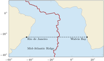
On a map of the South Atlantic, a student follows the parallel at latitude South. It leaves the coast of South America near Rio de Janeiro, at longitude West, crosses the ocean and the Mid-Atlantic Ridge, and reaches the coast of Africa near Walvis Bay, at longitude East. On this parallel, one degree of longitude measures . Across the ridge, at this latitude, the South American and African plates move apart at per year.
Part I — The clues of the fit.
- On the fossil map of this chapter, name the fossils whose bands cross from South America into Africa.
- Why can the fossils of Mesosaurus not be explained by an animal that swam from one continent to the other?
- Which part of South America fits into which part of Africa?
- What kind of plate boundary runs down the middle of the South Atlantic today? How do the two plates move there?
Part II — Measuring the ocean.
- How many degrees of longitude separate the two coasts along the parallel at South?
- What is the width of the ocean, in kilometres, along this parallel? Round to the nearest ten kilometres.
- At the equator, one degree of longitude measures . Why is it only at South?
- The ridge runs roughly down the middle of the ocean. About how far from the ridge is each coast?
Part III — The age of the ocean.
- Convert the speed at which the two plates move apart into kilometres per million years.
- If the ocean had always opened at this speed, how many million years would it have taken to reach its present width? Round to the nearest ten million years.
- Geologists date the break-up of Pangaea at between about 225 and 200 million years ago, and say that the Atlantic has grown over the last 100 to 200 million years. Does your answer agree with this?
- Give one reason why the true age of the South Atlantic may differ from the age you found.
Solution
Solution of Problem 18.1.
1. Mesosaurus, Cynognathus and Glossopteris (the band of Lystrosaurus joins Africa, India and Antarctica).
2. It lived in fresh water: it could not cross a salt ocean thousands of kilometres wide.
3. The bulge of north-east Brazil fits into the hollow of the Gulf of Guinea, on Africa’s west coast.
4. A divergent boundary, the Mid-Atlantic Ridge: the South American plate moves west and the African plate east, away from each other.
5. The coasts are on opposite sides of the prime meridian: .
6. : about .
7. The meridians come closer together as one goes from the equator towards a pole. The parallel at South is a smaller circle than the equator, so each of its 360 degrees is shorter.
8. About half the width: .
9. kilometres per million years.
10. : about 170 million years.
11. Yes: 170 million years lies between 100 and 200 million years, and it comes after the start of the break-up of Pangaea, 225 to 200 million years ago. A simple calculation on a map gives the right order of magnitude.
12. For example: the speed has not been the same all the time; the continents stretched and thinned before they split, so today’s coasts are not exactly the line along which they broke apart.