Primary & Middle School Earth and Space Sciences · الصفوف 1–9
31Landforms
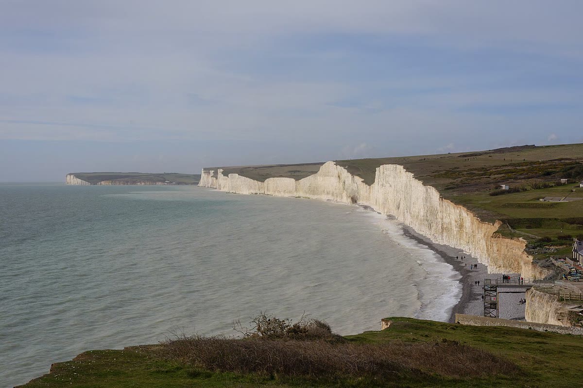
On the south coast of England, the white cliffs of the Seven Sisters drop straight into the sea. In a normal year they lose up to a metre. In the winter of 2014, storms took from the cliffs at Birling Gap as much as they usually lose in seven years, in two months. The chalk of these cliffs was once mud on the floor of a sea, made of the tiny plates of microscopic algae that lived in its water. Today it stands as a wall of white rock that the waves cut back a little further every year. Why does the land have the shapes it has, and why do some of them change so fast?
You already know
A landform is one shape of the land: a hill, a valley, a plain, a cliff (Chapter 2). The relief is the shape of the land in height (Chapter 9). Weathering breaks the rock, erosion wears it away and carries it off, and deposition lays it down elsewhere (Chapter 10). The plates push up mountain ranges where they collide (Chapter 18); glaciers carve U-shaped valleys (Chapter 27); limestone fizzes under a drop of dilute acid (Chapter 15). In chemistry, you learn that acids attack limestone and give off carbon dioxide.
31.1 The relief: a balance between uplift and erosion
Two kinds of forces shape the relief. From inside, the movements of the plates raise the ground. From outside, water, ice, wind and the sea wear it down.
Definition 31.1 (Uplift)
Uplift is the slow rise of the rocks and the ground surface of a region, driven by forces inside the Earth, such as the collision of two plates.
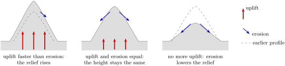
Uplift is slow on the scale of a life but fast on the scale of the Earth. India collided with Asia about 50 million years ago, and the Tibetan Plateau, behind the Himalaya, gained most of its height, about , in the last 10 million years. On average, that is m, or about a year: less than the thickness of a fingernail, but kept up for millions of years.
As soon as the ground rises, erosion attacks it. The higher and the steeper the land, the faster rivers, glaciers and rock falls carry rock away. The height of a mountain range at any moment is the result of a contest: what uplift brings up, minus what erosion takes away.
Rivers (Chapter 10) and glaciers (Chapter 27) are the great carvers of mountains. The rest of this chapter follows three other agents, which make landforms of their own: the wind, the sea, and water that dissolves rock.
31.2 Landforms made by the wind: dunes
Where plants are few, loose sand plentiful and the wind strong, the wind can pick up sand and heap it into hills: in deserts, and behind sandy beaches.
Definition 31.2 (Dune)
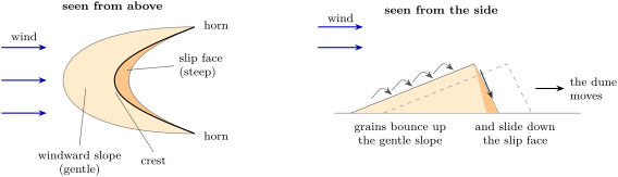
A dune is a mound or ridge of loose sand heaped up by the wind. Its slope facing the wind is long and gentle; its far side, the slip face, is short and steep.
A dune moves. The wind rolls and bounces the grains up the gentle slope; at the crest they pile up until the heap becomes too steep, and a little avalanche of sand slides down the slip face. Grain after grain, sand is taken from the windward side and laid on the far side, and the whole dune creeps downwind without ever being lifted. Dunes rarely stand alone: they cover whole fields.
Where the wind always blows from the same direction and sand is not too plentiful, dunes take the shape of a crescent, a barchan: its round nose faces the wind and its two horns point downwind. The horns hold less sand than the middle, so they move faster and stretch ahead of the dune.
How fast? In the gypsum dune field of White Sands, in New Mexico, the small dunes that form at its upwind edge, a few metres high, move up to a year; a little further on, grown to 6 to high, they move about a year. The more sand a dune holds, the slower it goes. Barchans driven by strong winds can travel more than in a year, enough to bury a road or a field.
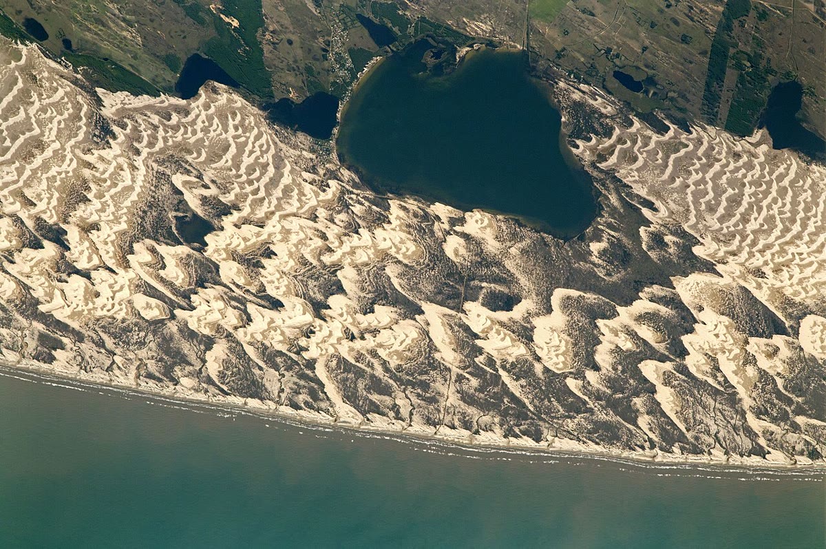
On a coast, a line of dunes behind the beach shields the land behind it from storm waves. Plants that grow on the dunes hold the sand with their roots: where they are trampled or cleared, the wind takes the sand again.
31.3 Landforms made by the sea
31.3.1 Cliffs
Definition 31.3 (Cliff)
A cliff is a steep or vertical face of rock. On a coast, a cliff is cut by the waves, which attack its foot and make it retreat inland.
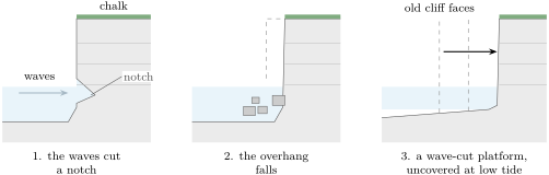
Waves hurl water, sand and pebbles at the foot of the cliff. Little by little they cut a hollow at its base, a notch, between the levels of low and high tide. The rock above overhangs; rain and frost weaken it further. One day the overhang falls. The waves break up the fallen blocks and carry them away, and the attack starts again on a fresh face, a little further inland. Behind it, the cliff leaves a flat shelf of rock, the wave-cut platform, which appears at low tide.
Soft rocks retreat fastest. At Birling Gap, the chalk cliffs lose up to about a metre a year; but the retreat comes in jumps, one fall at a time, and a stormy winter can take years of retreat at once. In 1999, the old Belle Tout lighthouse, built in 1832 on top of the cliffs nearby, was moved back from the edge, in one piece, because the cliff was coming too close.
Safety
The edge of a cliff can give way at any moment, and rocks fall from the face without warning. Cliffs are watched from a safe distance, well back from the edge at the top and well away from the foot on the beach, and a beach below cliffs is left before the tide comes in.
31.3.2 Beaches and spits
The sand and pebbles worn from cliffs, and brought down by rivers, do not stay where they fall: the waves sort them and move them along the coast.
Definition 31.4 (Beach, longshore drift and spit)
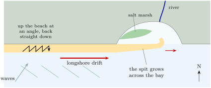
A beach is a strip of sand or pebbles piled up by the waves along the shore. When the waves reach the shore at an angle, each wave pushes the grains up the beach at that angle and the water runs back straight down the slope: the grains zigzag along the coast. This movement of sand and pebbles along the shore is longshore drift. A spit is a long, narrow ridge of sand or pebbles built by longshore drift, joined to the land at one end and running out into the sea where the coast turns.
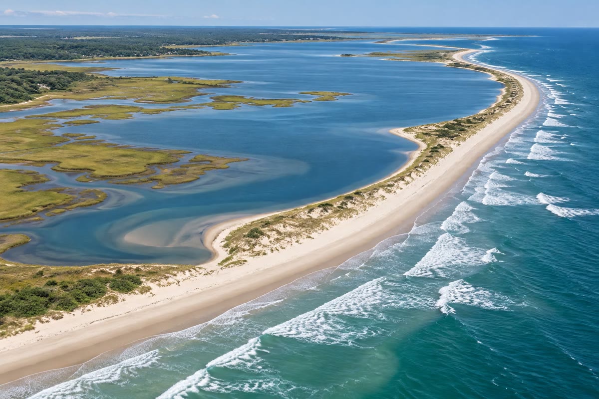
Where the coast bends, at the mouth of a bay or of a river, the drift carries on in the same direction and drops its load in the calmer water: the beach grows out into the sea as a spit. Its end often curls inward, bent by waves coming from other directions. Behind the spit, sheltered from the waves, mud settles and salt marshes grow.
31.4 Landforms made by dissolution: karst
Rainwater is not pure water. Falling through the air and then soaking through the soil, it takes up carbon dioxide, which makes it slightly acidic. This weak acid does slowly what the drop of dilute acid does fast to a piece of limestone: it dissolves the rock. Limestone is full of cracks, along its layers and across them. Water seeps down them and widens them, millimetre by millimetre, over thousands of years.
Definition 31.5 (Karst, cave and sinkhole)
A karst is a landscape shaped by water dissolving a soluble rock, most often limestone. Rivers there tend to vanish underground and come back out as springs. A cave is a natural underground space large enough for a person to enter, dissolved along the cracks of the rock. A sinkhole is a hollow or a hole in the ground surface, formed where the rock below dissolves away or where the roof of a cave collapses.
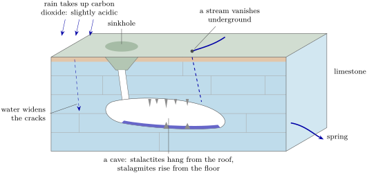
In a cave, dissolution can run backwards. A drop of water seeping from the roof carries dissolved limestone. When it meets the air of the cave, it gives off some of its carbon dioxide, and a thin film of calcite comes out of the water around the drop. Drop after drop, a hollow tube grows from the roof, then thickens into a stalactite, hanging like an icicle. Where the drops land, the rest of the calcite builds a stalagmite up from the floor. When the two meet, they make a column.
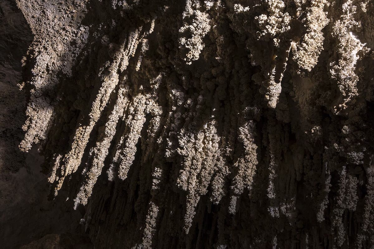
Karst country holds much water underground, but it flows fast through the open cracks and is hardly filtered: whatever is spilled on the ground can reach a spring quickly. And where the rock below has been dissolved, the ground can sink or collapse: where people live, a sinkhole that opens suddenly can swallow roads and houses.
31.5 Reading a landscape
Every landform is a clue. Its shape tells which agent made it; the agent tells which process was at work, erosion or deposition; and the process often tells something about the rock or the loose material underneath.
Method 31.6 (Reading a landform)
- Shape. Describe the landform: a ridge, a hollow, a steep face, a flat shelf; its size; which way it points.
- Agent and process. Decide which agent made it (a river, ice, the wind, the sea, dissolving water) and whether it was carved (erosion) or built (deposition).
- Material. Say what it is made of, or what the rock below is likely to be: loose sand, pebbles, limestone, hard or soft rock.
| shape | agent | process | material |
|---|---|---|---|
| crescent-shaped hills of sand | wind | deposition | loose sand |
| a vertical rock face above a flat rock shelf | sea | erosion | rock (soft rock retreats fast) |
| a narrow ridge of sand across a bay | sea (longshore drift) | deposition | sand or pebbles |
| hollows in fields, streams that vanish | dissolving water | dissolution | limestone |
| a U-shaped valley | ice | erosion | any rock |
| a fan of mud at a river mouth | river | deposition | mud and sand |
Example 31.7 (A walk on a plateau)
On a high grassy plateau, there is no stream at all, although it rains often. The fields are dotted with round hollows a few metres across, and in the valley below a powerful spring gushes out of the foot of a rock face. Shape: hollows, no streams on the surface, a spring lower down. Agent and process: water dissolving the rock and flowing underground. Material: the plateau is most likely limestone, and the hollows are sinkholes. A drop of dilute acid on a loose piece of the rock, put by the teacher, would fizz.
31.6 Exercises
Exercise 31.1 ★
Which agent made each landform: the wind, the sea, a river, ice, or water dissolving the rock? (a) A crescent-shaped hill of sand in a desert. (b) A cave full of stalactites. (c) A long ridge of pebbles across the mouth of a bay. (d) A U-shaped valley with a moraine at its end. (e) A vertical chalk face with a flat rock shelf at its foot. (f) A delta.
Exercise 31.2 ★
Give the word for each description. (a) The slow rise of the rocks and the ground of a region. (b) The steep side of a dune, away from the wind. (c) A hole in the ground formed where the rock below has dissolved or a cave roof has collapsed. (d) The movement of sand and pebbles along the shore. (e) A landscape shaped by water dissolving limestone.
Solution
Solution of Exercise 31.2.
(a) Uplift. (b) The slip face. (c) A sinkhole. (d) Longshore drift. (e) A karst.
Exercise 31.3 ★
True or false? Correct the false sentences. (a) The horns of a crescent dune point towards the wind. (b) The slope of a dune facing the wind is gentle. (c) A dune moves because the wind lifts it all at once. (d) Dunes form more easily where few plants grow.
Solution
Solution of Exercise 31.3.
(a) False: the horns point downwind; the round nose faces the wind. (b) True. (c) False: the wind moves it grain by grain, up the gentle slope and down the slip face. (d) True.
Exercise 31.4 ★
Put these steps of the retreat of a sea cliff in order. (a) The waves break up the fallen blocks and carry them away. (b) The waves cut a notch at the foot of the cliff. (c) The cliff face now stands further inland, and the flat platform in front of it is a little wider. (d) The rock above the notch overhangs. (e) The overhang falls.
Solution
Solution of Exercise 31.4.
(b), (d), (e), (a), (c).
Exercise 31.5 ★★
Seen from an aircraft, the crescent dunes of a desert all have their horns pointing to the east. (a) From which direction does the wind blow? (b) On which side of each dune is the slip face? (c) A road runs east of one of the dunes. The dune moves a year. In how many years will its foot reach the road? (d) A larger dune moves only a year. Why do larger dunes move more slowly?
Exercise 31.6 ★★
The chalk cliffs of a coast retreat by up to about a year. In the winter of 2014, they lost as much as they usually lose in seven years, in only two months. (a) At a year, how much is lost in seven years? (b) Two months is what fraction of a year? (c) How many times faster than usual did the cliffs retreat during those two months? (d) Explain, using the notch and the overhang, why a cliff retreats in jumps rather than smoothly.
Solution
Solution of Exercise 31.6.
(a) . (b) of a year. (c) Seven years of retreat in of a year: times faster. (d) The waves first cut a notch; the rock above hangs over it for a while, without moving; then the overhang falls all at once, and the edge jumps back.
Exercise 31.7 ★★
A straight coast runs west–east, with the sea to the south. The waves come from the south-west. (a) In which direction does the longshore drift carry the sand? (b) Draw the zigzag path of a pebble over three waves, labelling the stroke up the beach and the stroke back down. (c) At its east end the coast turns north into a bay. What landform is likely to grow there? (d) Why does mud settle behind it?
Solution
Solution of Exercise 31.7.
(a) Towards the east. (b) Three strokes up the beach slanting to the north-east, each followed by a stroke straight back down to the south: a zigzag moving east. (c) A spit, growing eastward across the mouth of the bay. (d) The spit shelters the water behind it from the waves; in calm water, the fine mud can settle.
Exercise 31.8 ★★
(a) What makes rainwater slightly acidic? (b) Why are there caves in limestone but hardly any in granite? (c) Why do the caves follow the cracks and layers of the rock? (d) Give two ways a sinkhole can form.
Solution
Solution of Exercise 31.8.
(a) It takes up carbon dioxide from the air and from the soil. (b) The weak acid dissolves limestone slowly, but hardly attacks granite. (c) The water can only enter the rock through its cracks and along its layers; it widens these openings first. (d) The rock below the surface is dissolved and the ground sinks slowly; or the roof of a cave collapses.
Exercise 31.9 ★★
(a) Explain why calcite comes out of a drop of water hanging from a cave roof. (b) Why do stalagmites have no hollow tube inside, unlike young stalactites? (c) Suppose a stalactite has grown a year (an invented rate: real rates vary a lot). How many years has it taken to grow ? Write the answer in scientific notation.
Solution
Solution of Exercise 31.9.
(a) When the drop meets the air of the cave, it gives off some of its carbon dioxide and can no longer hold all of the dissolved limestone, which comes out as calcite. (b) A stalagmite grows from drops that splash on the floor and spread out; there is no drop hanging at its tip to build a tube. (c) ; years.
Exercise 31.10 ★★
The Tibetan Plateau rose about in about 10 million years. (a) Compute the average uplift in metres per year, in scientific notation, then in millimetres per year. (b) Suppose erosion removes a year from the plateau (an invented figure). By how much does the plateau rise each year? (c) A chalk cliff retreats about a year. How many times faster is that than the uplift of (a)? (d) Why can a slow uplift still build a high plateau?
Solution
Solution of Exercise 31.10.
(a) m a year, or a year. (b) a year. (c) ; , about two thousand times faster. (d) It is kept up for millions of years: mm, about .
Exercise 31.11 ★★★
Read each landscape with the method of the chapter (shape, agent and process, material). (a) In a dry country, long lines of sand hills, each shaped like a crescent, with a steep side facing south-east. (b) At the foot of a white cliff, a flat rock shelf covered with seaweed appears at low tide. (c) On a wide plateau of pale rock, a stream flows across a field and disappears into a hole; a spring gushes out of a valley side away.
Solution
Solution of Exercise 31.11.
(a) Shape: crescent dunes with their slip face on the south-east side. Agent and process: the wind, blowing from the north-west, deposition. Material: loose sand. (b) Shape: a cliff above a flat shelf uncovered at low tide. Agent and process: the sea, erosion; the shelf is a wave-cut platform left by the retreating cliff. Material: white rock, probably chalk, a soft rock. (c) Shape: a stream that vanishes into a hole, a spring far away. Agent and process: water dissolving the rock and flowing underground. Material: limestone; the plateau is a karst.
Exercise 31.12 ★★★
In a dune field, the small dunes at the upwind edge move up to a year; a little further on, the dunes, 6 to high, move about a year. A track crosses the field downwind of a dune of each kind. (a) After how many years does each dune reach the track? (b) Dunes driven by strong winds can travel more than in a year. How long would such a dune take to cover the same distance? (c) Name one way to slow the dunes down, and explain how it works.
31.7 Problem: The cliff and the coast road
Problem 31.1
Weekend problem — a coast road runs behind a retreating chalk cliff; the final answer is the year the cliff edge would reach the road at the measured rate
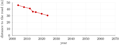
A coast road runs along the top of chalk cliffs. Every few years, a survey team measures the distance from the road to the cliff edge along the same line, from fixed markers set well back from the edge, never at the edge itself. Here are their measurements.
| year | 2004 | 2008 | 2012 | 2014 | 2016 | 2020 | 2024 |
|---|---|---|---|---|---|---|---|
| distance from the road to the edge (m) | 46.0 | 43.1 | 41.0 | 36.2 | 35.5 | 33.0 | 30.4 |
Part I — The measurements.
- By how many metres did the cliff edge move closer to the road between 2004 and 2024?
- Compute the average rate of retreat over these 20 years, in metres per year.
- Between which two surveys did the edge retreat fastest? Compute the rate over that interval.
- How many times faster than the average is it? Suggest what happened during that interval.
Part II — The rate.
- Write the average rate in centimetres per year, then in metres per century.
- On a real chalk coast, the cliffs retreat by up to about a metre a year. Is this cliff’s retreat of the same size?
- A lighthouse on such a coast was once moved back from the edge. At this cliff’s average rate, how many years of retreat does represent?
- Why is the rate measured over 20 years a better guide to the future than the rate measured over two years?
Part III — The road.
- The road is to be moved before the edge comes within of it. In which year, at the average rate, will that be?
- If stormier winters doubled the rate, in which year would the edge reach the road?
- Why does the survey team take its measurements from markers set well back from the edge?
- At the average rate, in which year would the cliff edge reach the road?
Solution
Solution of Problem 31.1.
1. .
2. a year.
3. Between 2012 and 2014: in two years, or a year.
4. times faster. Probably a stormy winter, during which large overhangs fell.
5. a year; per century.
6. Yes: a year is a little less than a metre a year.
7. years.
8. The cliff retreats in jumps: a two-year interval may hold a large fall, or none at all. Over 20 years, the jumps and the calm years average out.
9. The edge has to go: years, so in 2050.
10. a year; years after 2024, so in 2043.
11. The edge of a cliff can give way at any moment; standing on it, or near it, is dangerous.
12. years after 2024: in 2063.