বইগুলো এখনো বাংলা ভাষায় পাওয়া যায় না — ইংরেজি সংস্করণ দেখানো হচ্ছে।
Primary & Middle School Earth and Space Sciences · শ্রেণি 1–9
26The Oceans
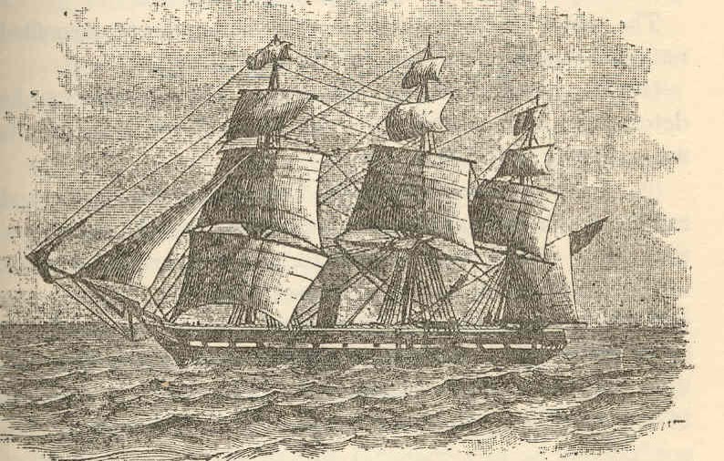
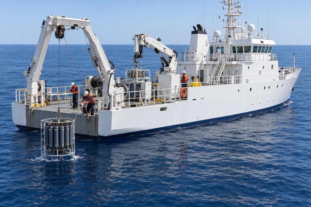
In December 1872, a British navy ship, HMS Challenger, left England for a voyage of three and a half years around the world. Its task was new: to find out what lies at the bottom of the oceans. Again and again the ship stopped in the open sea, and the crew lowered a heavy weight on a long rope until it touched the bottom; the length of rope paid out gave the depth. When the ship came home in May 1876, its soundings had shown that the ocean floor has deep plains and great mountain ranges.
Today a ship maps the sea floor with sound. A device under its hull sends a short pulse of sound downwards; the sound bounces off the bottom and comes back as an echo. The time the echo takes gives the depth, again and again, while the ship keeps sailing. This is sonar.
You already know
Salt water covers most of the Earth, in one world ocean divided into oceans and seas (Chapter 3). Plates move apart at the ocean ridges and one plate sinks under another at the trenches (Chapter 18). Over the oceans, the winds blow in great belts: trade winds, westerlies and polar easterlies, turned aside by the Earth’s rotation (Chapter 24).
26.1 The ocean floor
If the water of the oceans could be drained away, a whole hidden landscape would appear. Along the coasts, the land goes on under the sea as a gentle, shallow shelf. Then the floor plunges down a steep slope to vast, flat plains, kilometres deep. Mountain ranges rise from these plains, and here and there narrow trenches go down deeper than anything else on Earth.
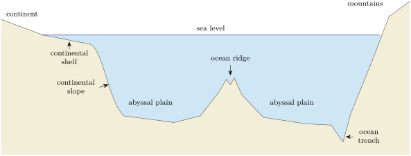
Definition 26.1 (The parts of the ocean floor)
- The continental shelf is the shallow, gently sloping edge of a continent under the sea.
- The continental slope is the steep slope that leads down from the shelf to the deep ocean floor.
- An abyssal plain is a vast, very flat and deep part of the ocean floor.
- An ocean ridge is a long chain of underwater mountains rising from the abyssal plains.
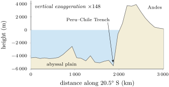
- An ocean trench is a long, narrow and very deep trough in the ocean floor, often next to a chain of mountains or volcanic islands.
The ocean is about deep on average, almost half the height of the highest mountain on land. Its deepest point, the Challenger Deep in the Mariana Trench in the Pacific Ocean, is nearly below the surface.
Method 26.2 (Reading a profile of the ocean floor)
- Read the axes: the distance across, the height or depth up and down, and the vertical exaggeration.
- Find sea level (height 0) and the coasts where the profile crosses it.
- Follow the floor from a coast: the shallow shelf, the steep slope, then the deep flat plains.
- Look for what rises from the plains (a ridge) or drops below them (a trench), and read its depth.
Example 26.3 (Across the South Atlantic)
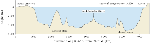
On the top profile, past the coast of South America, the floor drops to more than deep in less than . Abyssal plains, between and deep, fill most of the width. Half-way across, about along the profile, the Mid-Atlantic Ridge rises to about below the surface: more than above the plains, a mountain range hidden under the sea. The plains deepen again to more than before the floor climbs to Africa.
26.2 Salty water
Sea water tastes salty because salts are dissolved in it. Most of them come from the rocks of the continents: rain slowly wears the rocks away and rivers carry their dissolved salts to the sea. Some come from hot springs on the ocean floor.
Definition 26.4 (Salinity)
The salinity of sea water is the mass of salts dissolved in a kilogram of sea water. On average it is about per kilogram: of the mass of sea water is salt.
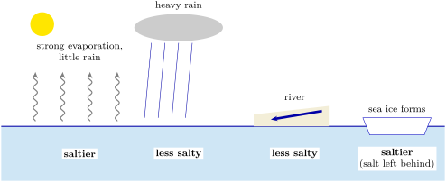
The salinity is not the same everywhere. When sea water evaporates, the water leaves but the salts stay behind: where the Sun is strong and rain is rare, the sea becomes saltier. Where much rain falls, or where a large river flows in, the sea is less salty. When sea water freezes into sea ice, the salt is left in the water around, which becomes saltier too. On the whole, the salinity is low near the equator, where it rains a lot, and near the poles; it is highest in the middle latitudes, under the dry belts near .
26.3 Currents at the surface
The ocean is never still. The winds drag on its surface and set the water moving: the steady trade winds push it towards the west near the equator, and the westerlies push it towards the east in the middle latitudes. Like the winds, the moving water is turned aside by the Earth’s rotation: to the right in the northern hemisphere, to the left in the southern hemisphere.
Definition 26.5 (Ocean current and gyre)
An ocean current is a steady movement of sea water in one direction, like a river in the ocean. A gyre is a very large loop of ocean currents that turns round an ocean basin.
There are five great gyres: in the North and South Atlantic, in the North and South Pacific, and in the Indian Ocean. Those of the northern hemisphere turn clockwise, those of the southern hemisphere anticlockwise. On the western side of each ocean, the gyre’s current is narrow and fast; on the eastern side, it is broad and slow.
In the lab — A gyre in a dish
Indoors, fill a large round dish with water and sprinkle a pinch of pepper on the surface. Blow gently and steadily across the dish through a straw, always in the same direction, close to one edge. Watch the pepper: the water near the surface starts to move with your breath, and soon the whole surface turns in a loop round the dish.
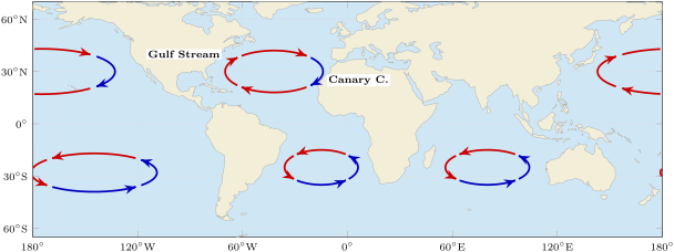
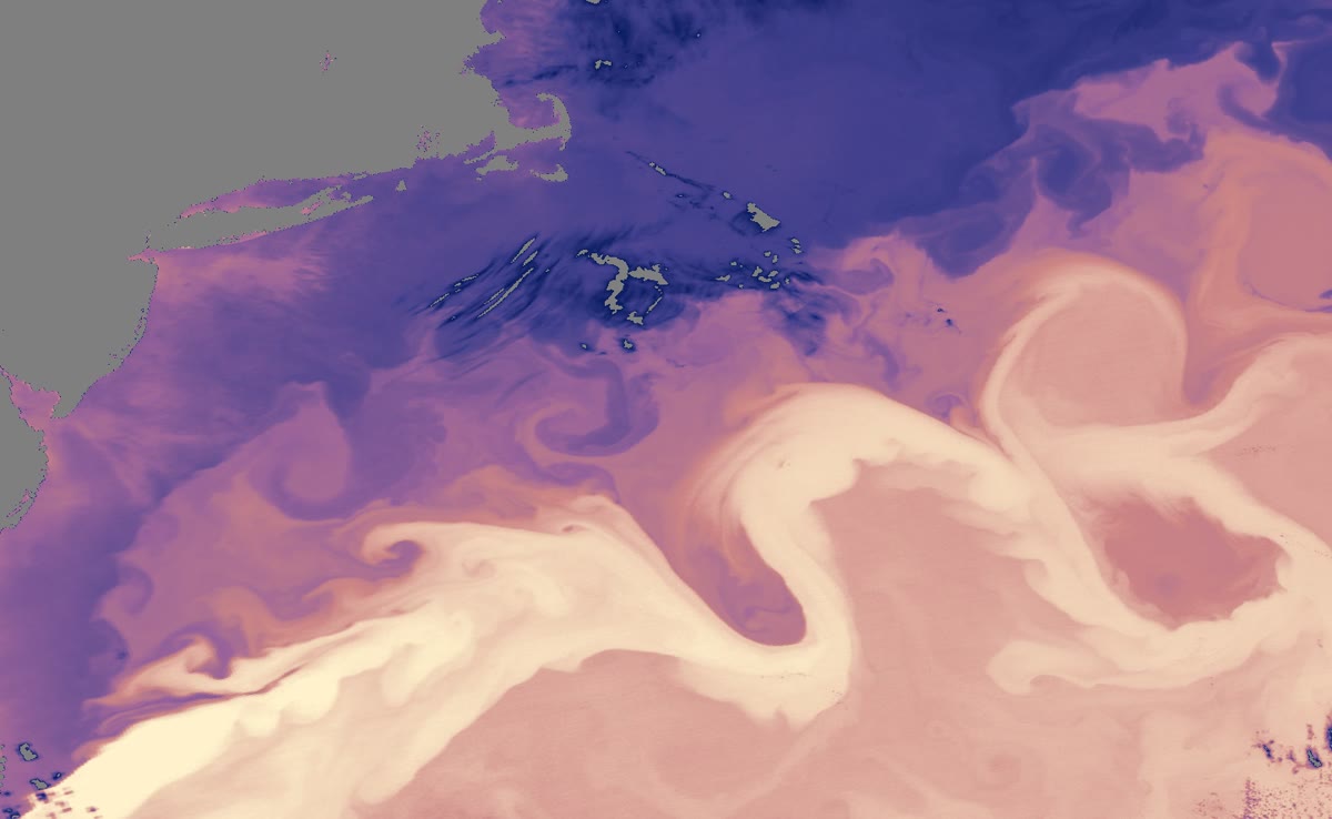
The best known of these currents is the Gulf Stream. It leaves the Gulf of Mexico, runs north along the coast of Florida, turns east off North Carolina and crosses the Atlantic towards the north-east. Its warm water moves on average at about per hour, up to about per hour at the surface, and it carries more water than all the rivers of the world together. It keeps the east coast of Florida warmer in winter and brings mild air to western Europe.
26.4 Deep currents and the ocean’s heat
The winds drive the currents at the surface. Far below, in the cold darkness of the deep ocean, the water moves too, much more slowly. In the far North Atlantic, the warm water brought by the Gulf Stream gives its heat to the cold air; cooled, and made saltier when sea ice forms, it becomes denser and sinks to the bottom. This cold, salty water creeps south along the ocean floor, all the way to Antarctica, then into the Indian and Pacific Oceans, where it slowly rises and returns at the surface. A drop of water can take about years to go once round this great loop, the global ocean conveyor belt.
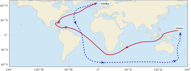
Example 26.6 (How slow is the deep water?)
The loop drawn on the map is roughly long. If a drop of water takes about years to go round it, it moves on average about a year, that is about a day. The Gulf Stream, at an hour, covers about in a day: it goes as far in about 11 hours as the deep water in a whole year.
Together, the surface and deep currents carry heat: warm water flows from the tropics towards the poles, and cold water flows back towards the equator. Like the winds, the ocean evens out the uneven heating of the Earth by the Sun.
26.5 Exercises
Exercise 26.1 ★
Put these parts of the ocean floor in the order in which a submarine meets them as it leaves a coast for the middle of the Atlantic: abyssal plain; continental slope; ocean ridge; continental shelf.
Solution
Solution of Exercise 26.1.
Continental shelf, continental slope, abyssal plain, ocean ridge.
Exercise 26.2 ★
True or false? Correct the false sentences. (a) The ocean is about deep on average. (b) The gyres of the northern hemisphere turn clockwise. (c) Evaporation makes sea water less salty. (d) The Gulf Stream is a warm current.
Solution
Solution of Exercise 26.2.
(a) False: about , that is . (b) True. (c) False: evaporation removes water and leaves the salts, so the water gets saltier. (d) True.
Exercise 26.3 ★
Give the word for each description: (a) a long chain of mountains under the sea; (b) the mass of salt in a kilogram of sea water; (c) a very large loop of ocean currents; (d) a long, narrow and very deep trough in the ocean floor.
Solution
Solution of Exercise 26.3.
(a) An ocean ridge. (b) The salinity. (c) A gyre. (d) An ocean trench.
Exercise 26.4 ★
On the map of the gyres: (a) which way does the gyre of the South Atlantic turn? (b) Name a warm current and a cold current of the North Atlantic. (c) Which winds push the water towards the west near the equator?
Solution
Solution of Exercise 26.4.
(a) Anticlockwise. (b) Warm: the Gulf Stream; cold: the Canary Current. (c) The trade winds.
Exercise 26.5 ★★
A sample of of sea water contains of salts. (a) What percentage of its mass is salt? (b) How many grams of salts are there in of this water? (c) How many kilograms of sea water contain of salts?
Solution
Solution of Exercise 26.5.
(a) . (b) . (c) : about .
Exercise 26.6 ★★
A ship’s sonar sends a pulse of sound straight down. The echo comes back later. Sound travels about each second in sea water. (a) How far does the sound travel in ? (b) Why is the depth only half of this distance? (c) What is the depth? (d) Which part of the ocean floor could the ship be above?
Solution
Solution of Exercise 26.6.
(a) . (b) The sound goes down to the bottom and comes back up: it covers the depth twice. (c) . (d) An abyssal plain (a trench would be deeper, a ridge or a shelf shallower).
Exercise 26.7 ★★
Use the profile across the South Atlantic. (a) How deep are the abyssal plains, roughly? (b) At what distance along the profile is the crest of the Mid-Atlantic Ridge, and how deep is it? (c) By how many metres does the ridge rise above the plains? (d) Why does the profile need a vertical exaggeration?
Solution
Solution of Exercise 26.7.
(a) Between about and . (b) About along the profile, about deep. (c) About (between 1200 and , depending on the plain chosen). (d) The ocean is a few kilometres deep but thousands of kilometres wide: drawn at the same scale, the whole profile would be thinner than a line.
Exercise 26.8 ★★
Sea A lies between two deserts: it hardly ever rains there and no large river flows into it. Sea B, in a rainy region, receives many large rivers. Explain which of the two is saltier than the open ocean, and which is less salty. Use the words evaporation, fresh water, salts stay behind.
Solution
Solution of Exercise 26.8.
Sea A is saltier: the Sun and the dry air cause strong evaporation, the water leaves, the salts stay behind, and almost no rain or river brings fresh water back. Sea B is less salty: its rivers and its rain bring a lot of fresh water, which dilutes the salts.
Exercise 26.9 ★★
A message in a bottle is thrown into the sea off the coast of Florida. (a) Which current carries it first, and in which direction? (b) Which way does it then cross the Atlantic? (c) If it went on round the gyre, along which coast would it travel south? (d) Is this current warm or cold?
Exercise 26.10 ★★
The Gulf Stream moves on average at about per hour. (a) How far does its water travel in one day? (b) In a week? (c) Compare with a person walking at per hour.
Solution
Solution of Exercise 26.10.
(a) : about . (b) . (c) The Gulf Stream is a little faster than a walker, but it never stops, day and night.
Exercise 26.11 ★★★
The ocean is about deep on average, and its deepest point is nearly deep. (a) Write both depths in kilometres. (b) How many times deeper than the average is the deepest point? Round to one decimal. (c) A sonar echo from the deepest point: how many seconds does it take to come back, at each second? (d) A drop of water of the conveyor belt sinks in the North Atlantic. If it takes about years to go round, how many years is that in powers of ten?
Solution
Solution of Exercise 26.11.
(a) and . (b) times. (c) The sound travels ; : about . (d) years.
Exercise 26.12 ★★★
The great conveyor belt of the deep ocean starts in the Norwegian Sea, off the coast of Norway, where warm water brought by the Gulf Stream gives its heat to the cold air. (a) Using the gyres map and the chapter, explain step by step how this warm water travelled there from the tropics, and which winds pushed it. (b) Explain why the water then sinks. (c) Where does it go next?
Solution
Solution of Exercise 26.12.
(a) Near the equator, the trade winds push warm tropical water towards the west. At the western edge of the Atlantic it turns north with the Gulf Stream, a warm current, along Florida and North America. The westerlies then push it across the Atlantic towards the north-east, as far as the seas off Norway. (b) There it gives its heat to the cold air: it cools, and it becomes saltier when sea ice forms, because the salt is left in the water. Cold, salty water is dense, so it sinks to the bottom. (c) It creeps south along the ocean floor, towards Antarctica, then into the Indian and Pacific Oceans, where it slowly rises again.
26.6 Problem: A drifting buoy
Problem 26.1
Weekend problem — a drifting buoy is launched off Florida and carried round the North Atlantic gyre; its journey is followed leg by leg, and the time it takes to go once round is worked out
Scientists launch a drifting buoy off the coast of Florida. It floats just under the surface, moves with the currents, and sends its position to a satellite. Its batteries last about one year. The map shows the four legs of its journey round the North Atlantic gyre.
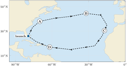
| leg | current | length (km) | average speed (km per day) |
|---|---|---|---|
| A | Gulf Stream | 3800 | 100 |
| B | North Atlantic Current | 2100 | 20 |
| C | Canary Current | 3100 | 20 |
| D | North Equatorial Current | 6100 | 20 |
Part I — The launch.
- In which ocean, and in which hemisphere, is the buoy launched?
- Which way does the gyre turn? Is the buoy carried north or south at first?
- Is the water of leg A warm or cold? And of leg C? Explain.
- Which winds drive the currents of leg B? Of leg D?
Part II — Around the gyre.
- How many days does leg A take?
- How many days do legs B, C and D take?
- What is the total length of the journey round the gyre?
- Why is leg A so much faster than the others?
Part III — The journey’s length.
- How many days does the buoy need to go once round the gyre?
- Taking a month as 30 days, how many months is that? Round to the nearest whole month.
- On which leg will the batteries run out, after about one year (365 days)?
- How many more months of battery would the buoy need to send its position all the way round?
Solution
Solution of Problem 26.1.
1. In the Atlantic Ocean, in the northern hemisphere.
2. Clockwise; the buoy is carried north at first.
3. Leg A (Gulf Stream) is warm: it comes from the tropics. Leg C (Canary Current) is cold: it comes from higher latitudes, towards the equator.
4. Leg B: the westerlies. Leg D: the trade winds.
5. days.
6. B: days. C: days. D: days.
7. .
8. The Gulf Stream is the narrow, fast current on the western side of the gyre; the currents on the other sides are broad and slow.
9. days.
10. : about 20 months.
11. After legs A, B and C, days have passed; 365 days come during leg D (the North Equatorial Current), days into it.
12. more days, that is more months.