Primary & Middle School Earth and Space Sciences · Grades 1–9
24Winds and the Global Circulation
For centuries, sailing ships leaving the ports of Europe and Africa for the Americas relied on a steady wind from the east, which blows on both sides of the equator and carried them across the Atlantic. Sailors all over the world knew it, and the early trade with the Americas depended on it: it is the trade wind. Even now, cargo ships use the trade winds, and the ocean currents they drive, to shorten their voyages.
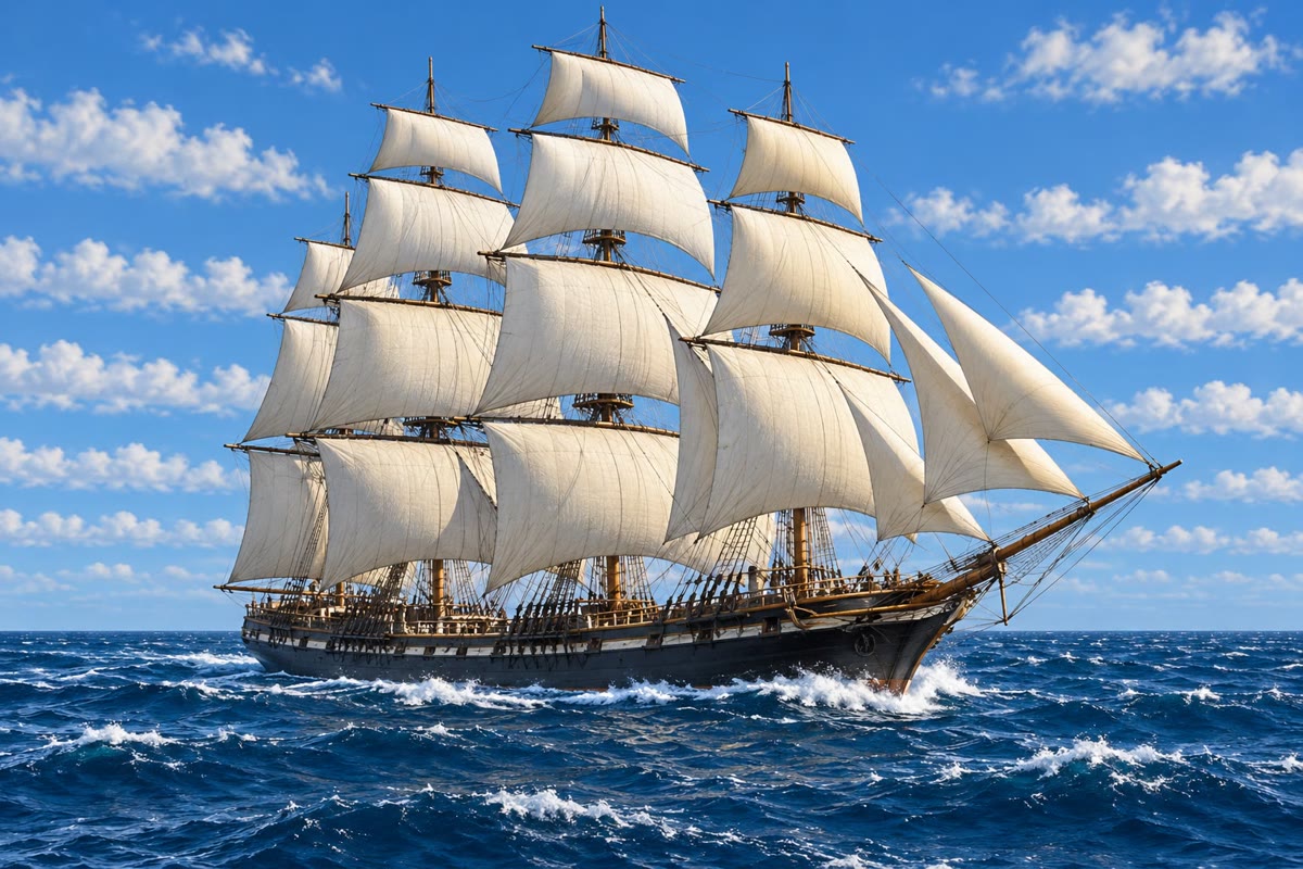
Why does the trade wind blow from the east, and always in the same places? Why are there deserts near the tropics and rainforests near the equator? The answer starts with the Sun.
You already know
Wind is air in motion (the physics books). Air presses on everything it touches, and the pressure falls with height (Chapter 23). The weather happens in the troposphere, the lowest layer of the atmosphere. The Earth has climate zones: hot and wet near the equator, with rainforests; hot and dry deserts near the tropics; temperate, then cold zones towards the poles (Chapter 11).
24.1 The Sun heats the Earth unevenly
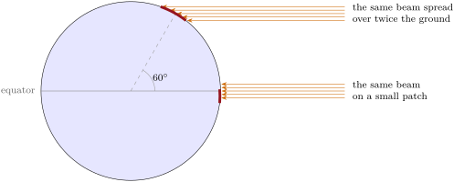
At noon on the day of an equinox, the Sun is straight overhead at the equator. Its rays arrive steeply there and fall on a small patch of ground. Further north or south, the same rays arrive at a slant and are spread over a larger patch: each square metre receives less of their energy. At latitude , the same beam covers twice the ground it covers at the equator, so each square metre gets half as much.
| latitude | |||||
|---|---|---|---|---|---|
| ground covered by the same beam | 1 | 1.15 | 1.41 | 2 | 3.86 |
| energy per square metre (% of the equator’s) | 100 | 87 | 71 | 50 | 26 |
As the Earth goes round the Sun, its tilted axis makes the overhead Sun move between the two tropics, which gives the seasons (the physics books); but all year round, the regions near the equator receive much more energy than those near the poles. This uneven heating is the main driver of the winds: the atmosphere carries warm air towards the poles and cold air towards the equator.
24.2 Rising and sinking air
Warm air is lighter than cold air: it rises, and the cooler air around flows in to take its place. Where air rises, it presses less on the ground: the pressure there is low. Where air sinks, it presses more: the pressure is high. At the ground, the wind blows from high pressure towards low pressure. Rising, cooling, sinking and flowing back, the air turns in a loop.
Definition 24.1 (Convection cell)
A convection cell in the atmosphere is a loop of moving air: air warmed from below rises, spreads out at height, cools and sinks somewhere else, and flows back along the ground to where it rose. Under the rising air the pressure is low; under the sinking air it is high.
In the lab — Warm air rises
Indoors, cut a spiral out of a sheet of thin paper, like the peel of an apple, and hang it by its centre on a thread. Hold it high above a warm radiator in winter (never above a flame or a candle): it slowly starts to turn. The air warmed by the radiator rises and pushes on the spiral. Hold it near a cold window: does it turn the other way, or not at all?
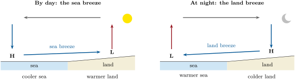
The smallest convection cells can be felt on a sunny day at the seaside. The land and the sea receive the same sunshine, but the Sun’s rays do not go deep into the ground, while the sea spreads its heat through a thick layer of water. So the land warms up much more by day, and cools down much more at night.
Definition 24.2 (Sea breeze and land breeze)
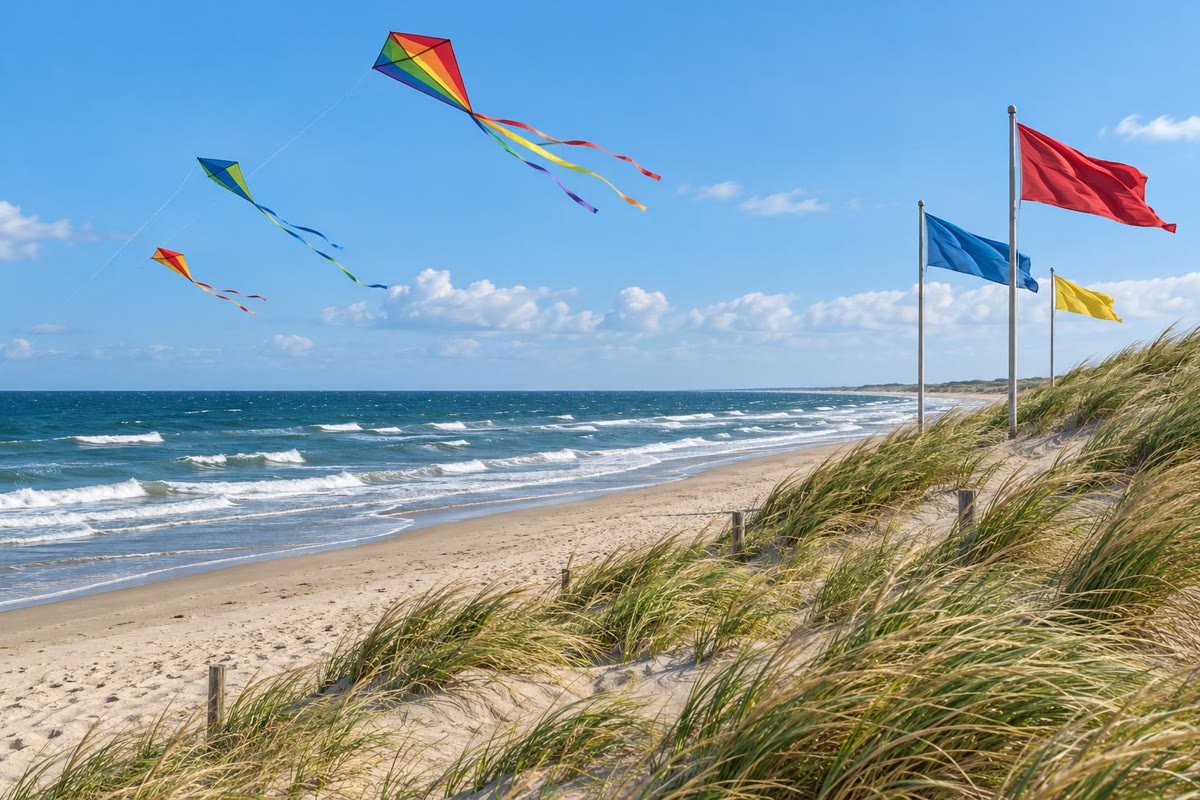
A sea breeze is a wind that blows from the sea towards the land by day, when the land is warmer than the sea. A land breeze blows from the land towards the sea at night, when the land has become colder than the sea.
24.3 The global winds
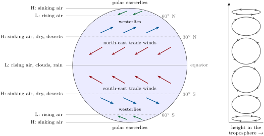
The same thing happens on the scale of the whole Earth. Near the equator, the strongly heated air rises; it spreads towards the poles at height and sinks again near of latitude. Averaged over many years, the troposphere of each hemisphere turns in three great convection cells: one from the equator to about , one from about to about , and one from about to the pole. Meteorologists call them the Hadley, Ferrel and polar cells. Their limits move with the seasons, and the middle cell is a rough average of many passing storms.
The winds that blow at the ground would go straight from high to low pressure if the Earth did not turn. Because the Earth rotates, moving air is turned aside: to the right in the northern hemisphere, to the left in the southern hemisphere. So the air flowing back to the equator does not come from the north, but from the north-east in the northern hemisphere and from the south-east in the southern hemisphere.
Definition 24.3 (The global winds)
The surface winds that blow most often in each belt of latitude are:
- the trade winds, between the equator and about , blowing from the north-east in the northern hemisphere and from the south-east in the southern hemisphere;
- the westerlies, between about and , blowing from the west (from the south-west in the northern hemisphere, from the north-west in the southern);
- the polar easterlies, between about and the poles, blowing from the east.
Method 24.4 (Finding the global wind at a latitude)
- Find the belt: from the equator to about , from to , or from to the pole.
- Find which way the air flows at the ground in that belt: towards the equator in the first and the last belt, towards the pole in the middle one.
- Turn this flow aside: to the right in the northern hemisphere, to the left in the southern hemisphere.
- Say where the wind comes from: winds are named after the direction they blow from.
Example 24.5 (The wind at south)
At S we are in the middle belt, between and . There the air at the ground flows towards the pole, that is towards the south. In the southern hemisphere it is turned to the left: for air going south, the left is the east, so the air ends up moving towards the south-east. It therefore comes from the north-west: it is one of the westerlies, blowing from the north-west.
Near the equator, where the trade winds of the two hemispheres meet, the winds die down: sailors called this belt of calm the doldrums. The warm, damp air rises there, cools and gives persistent showers and thunderstorms. Near , under the sinking air, the winds are light and rain is rare.
Definition 24.6 (Global circulation of the atmosphere)
The global circulation of the atmosphere is the large-scale movement of air around the planet, seen when the winds are averaged over many years. It carries heat from the equator towards the poles, and water vapour from one belt of latitude to another.
24.4 The global circulation and the climate zones
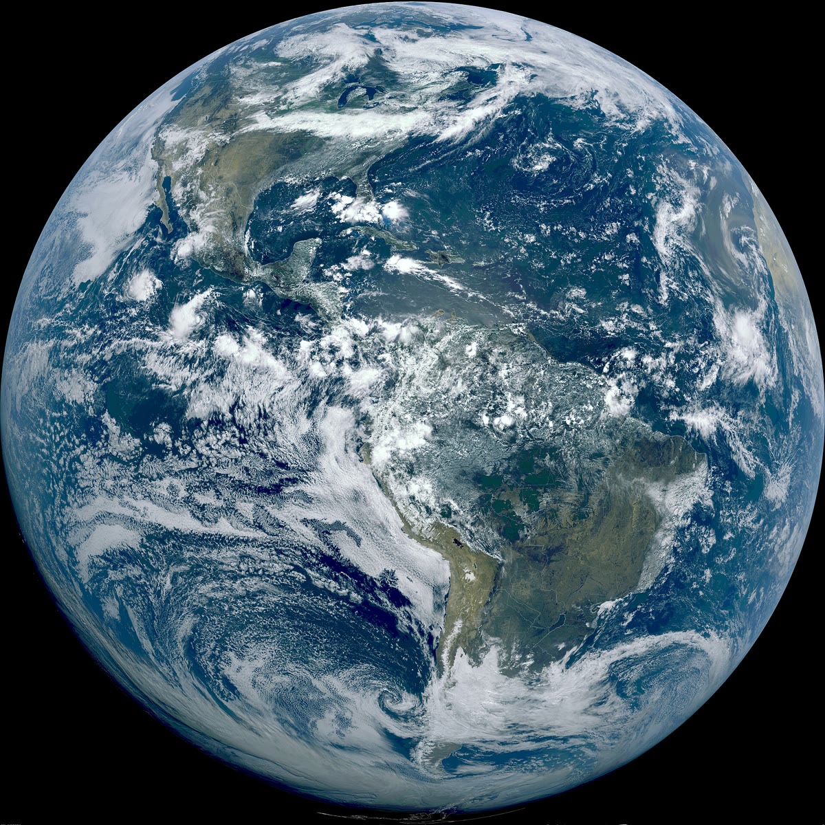
The global circulation explains much of the map of climates. Where air rises, near the equator, it cools and its water vapour turns into clouds: rain is frequent, and rainforests grow. Where the air sinks, near north and south, it warms as it comes down, its clouds dry up, and rain is rare: the great hot deserts, such as the Sahara, lie in these belts. In the middle latitudes, the westerlies bring one storm after another, with rain at all seasons.
Example 24.7 (Four towns, four belts)
The four towns of the climate charts of Chapter 11 all lie in the northern hemisphere, at very different latitudes. Their yearly rain and snow follow the belts of the global circulation (chart below). Hilo, at N, is on an island in the trade-wind belt, in the middle of the ocean, where the trade winds pick up water vapour: about fall there in a year. Phoenix, at N, lies close to , under the sinking air: less than . Seattle, at N, is in the westerlies, whose storms bring about a year, most of it from autumn to spring. Utqiaġvik, at N, lies under the cold air that sinks near the pole: less than , a cold desert.
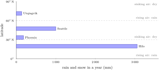
Four towns are only four points: mountains, coasts and cold or warm seas also change how much rain a place receives. The belts give the broad pattern of the map of climates, not the rain of every town.
24.5 Exercises
Exercise 24.1 ★
Name the global wind that blows most often: (a) at north; (b) at south; (c) at north; (d) at south. Give its direction each time.
Solution
Solution of Exercise 24.1.
(a) The north-east trade wind, from the north-east. (b) The westerlies, from the north-west. (c) The polar easterlies, from the east (from the north-east). (d) The south-east trade wind, from the south-east.
Exercise 24.2 ★
Complete each sentence. (a) Warm air … and cold air …. (b) Under rising air, the pressure at the ground is …. (c) At the ground, the wind blows from … pressure towards … pressure. (d) In the northern hemisphere, the Earth’s rotation turns moving air to the ….
Solution
Solution of Exercise 24.2.
(a) Warm air rises and cold air sinks. (b) Low. (c) From high pressure towards low pressure. (d) To the right.
Exercise 24.3 ★
True or false? Correct the false sentences. (a) A sea breeze blows from the land to the sea. (b) The land warms up faster than the sea by day. (c) The trade winds blow from the west. (d) Many great deserts lie near of latitude.
Solution
Solution of Exercise 24.3.
(a) False: a sea breeze blows from the sea to the land (by day). (b) True. (c) False: they blow from the east (from the north-east or the south-east). (d) True.
Exercise 24.4 ★
Draw a coast with the sea on the left and the land on the right. Add the Sun, then draw with arrows the loop of air of the sea breeze. Mark H and L where the pressure at the ground is high and low.
Solution
Solution of Exercise 24.4.
The drawing shows a loop: along the ground, an arrow from the sea to the land; over the land, an arrow going up; at height, an arrow from the land back over the sea; over the sea, an arrow going down. H is marked on the ground under the sinking air (over the sea), L under the rising air (over the land).
Exercise 24.5 ★★
Use the table of beams in this chapter. (a) At , how much more ground does a beam cover than at the equator? (b) What percentage of the equator’s energy does each square metre receive at ? (c) At ? (d) Explain in one sentence why the poles are cold.
Solution
Solution of Exercise 24.5.
(a) 1.41 times as much ground. (b) 50 %. (c) 26 %. (d) Near the poles, sunlight arrives at a slant and is spread over a large area, so each square metre receives little energy.
Exercise 24.6 ★★
A boat sails due south through the northern hemisphere and then the southern hemisphere. (a) Which winds does it meet, in order, from N to S? (b) Where is it likely to find calm air and frequent showers? (c) Where are winds light and rain rare?
Solution
Solution of Exercise 24.6.
(a) Polar easterlies ( to N), westerlies ( to N), north-east trade winds ( N to the equator), south-east trade winds (equator to S), westerlies ( to S), polar easterlies ( to S). (b) Near the equator, in the doldrums. (c) Near N and S, under the sinking air.
Exercise 24.7 ★★
At a beach, it is on the sand at 3 p.m. and over the sea. At 3 a.m. it is on the land and over the sea. (a) Which is warmer at 3 p.m.? Which way does the wind blow? (b) And at 3 a.m.? (c) By how many degrees does the land temperature change between the two times? And the sea temperature? (d) Explain the difference.
Solution
Solution of Exercise 24.7.
(a) The land (): the wind blows from the sea to the land, a sea breeze. (b) The sea (): the wind blows from the land to the sea, a land breeze. (c) The land: degrees; the sea: degree. (d) The Sun’s rays heat only a thin layer of ground, which warms and cools quickly; the sea spreads its heat through a thick layer of water, so its temperature hardly changes between day and night.
Exercise 24.8 ★★
Air flows from the high-pressure belt near N towards the equator. (a) Without the Earth’s rotation, from which direction would it blow? (b) Which way does the rotation turn it in this hemisphere? (c) From which direction does it blow then? (d) Answer the same three questions for the air flowing towards the equator from S.
Solution
Solution of Exercise 24.8.
(a) From the north. (b) To the right. (c) From the north-east (it is the north-east trade wind). (d) Without rotation it would blow from the south; the rotation turns it to the left; it blows from the south-east.
Exercise 24.9 ★★
Explain, step by step, why it rains so often near the equator: use the words heated, rises, cools, clouds. Then explain why there is a desert near N in North Africa: use the words sinks, high pressure, dry.
Solution
Solution of Exercise 24.9.
Near the equator, the ground and the sea are strongly heated by the Sun; the warm, damp air rises; as it rises it cools, and its water vapour turns into clouds, which give showers and thunderstorms. Near N, the air that rose at the equator sinks; under it the pressure at the ground is high; the sinking air warms, its clouds dry up and the region stays dry: a desert.
Exercise 24.10 ★★
A sailing ship leaves a port at N on the west coast of Europe for the Caribbean, at N. (a) Which wind would it meet at N? Would it help the ship sail west? (b) Why should the ship first sail south? (c) Which wind carries them west, and between which latitudes? (d) For the return voyage to Europe, which wind should the ship look for, and at what latitude?
Solution
Solution of Exercise 24.10.
(a) The westerlies. No: they blow from the west, against a ship sailing west. (b) To reach the belt of the trade winds, south of about N. (c) The north-east trade wind, between the equator and about N. (d) The westerlies, north of about N (near N, the latitude of the home port).
Exercise 24.11 ★★★
At latitude , a beam of sunlight at noon on an equinox covers times the ground it covers at the equator (on a calculator, ). (a) Check the value for . (b) Using , check the value for , rounded to two decimals. (c) Suppose a solar panel lying flat receives on each square metre at noon at the equator on that day. About how much would the same panel receive at ? At ?
Solution
Solution of Exercise 24.11.
(a) : the table gives 2. (b) , that is 1.15. (c) At : on each square metre (exactly ). At : .
Exercise 24.12 ★★★
In each hemisphere, the global circulation has three cells. (a) Draw a side view of the northern hemisphere, with the equator at the bottom and the pole at the top, and the three cells as loops; show where the air rises and where it sinks. (b) Mark the high and low pressure belts at the ground. (c) Add the surface winds of each cell, turned to the right. (d) Use your drawing to explain why the westerlies blow towards the north-east.
Solution
Solution of Exercise 24.12.
(a) Three loops: air rises at the equator and sinks near ; rises near and sinks near ; rises near and sinks at the pole. (b) L at the equator and near ; H near and at the pole. (c) From to the equator, the surface air goes south and is turned to the right: north-east trade wind. From to , it goes north and is turned to the right: it comes from the south-west. From the pole to , it goes south, turned to the right: polar easterly. (d) In the middle cell the surface air flows towards the pole, that is north; turned to the right, it heads towards the north-east: these are the westerlies.
24.6 Problem: Sailing with the trade winds
Problem 24.1
Weekend problem — a sailing ship crosses the Atlantic from Cape Verde to Barbados with the north-east trade wind; the route is measured on the map, the wind is read, and the length of the crossing is worked out
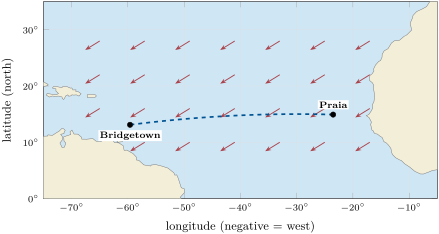
A sailing ship leaves Praia, in the Cape Verde Islands, for Bridgetown, in Barbados. The map shows the route and the trade wind.
Part I — The route.
- Praia lies at N, W; Bridgetown at N, W. How many degrees of longitude separate them?
- Both ports lie close to N. Along this parallel, one degree of longitude measures about . About how many kilometres is the crossing? Round to the nearest hundred.
- Measured exactly on the round Earth, the shortest route is . Is the answer of question 2 a good estimate?
- Do the ports lie in the belt of the trade winds? Explain.
Part II — The wind.
- From which direction does the trade wind blow here?
- The ship sails towards the west. Does the wind push it forwards, backwards or sideways? Explain with the map.
- Why does the trade wind blow in the same direction almost every day of the crossing?
- On the way back to Europe, why should the captain not try to sail east along N?
Part III — The crossing.
- Suppose the ship averages per hour. How many kilometres does it cover in a day of 24 hours?
- If the wind died down for 3 days on the way, how many kilometres of progress would the ship lose?
- With a steady trade wind, how many days does the ship need for ? Round to one decimal.
- To the nearest whole day, how long does the crossing last? Is it more or less than a month?
Solution
Solution of Problem 24.1.
1. degrees of longitude.
2. : about .
3. Yes: km, a tiny difference.
4. Yes: both lie near N, between the equator and about N, the belt of the north-east trade wind.
5. From the north-east (the arrows point towards the south-west).
6. Forwards, and a little sideways: the wind comes from behind the ship, slightly from its right, and pushes it towards the west.
7. It is part of the global circulation: air keeps sinking near N and rising near the equator, so the surface air keeps flowing towards the equator, and the Earth’s rotation always turns it to the right.
8. The trade wind would blow against the ship. The captain should sail north, beyond about N, to find the westerlies.
9. a day.
10. .
11. days.
12. About 23 days: less than a month.