书籍暂未推出简体中文版——当前显示英文版。
Primary & Middle School Earth and Space Sciences · 1–9 年级
14Latitude, Longitude and Time Zones
Night has fallen on the ocean. On the deck of a sailing ship, in the year 1750, the navigator lifts his instrument towards a bright star and measures how high it stands above the sea. A few minutes of work, and he knows how far north of the equator the ship is. But how far east or west? That, he cannot tell. The problem was so serious that in 1714 the British parliament had promised a large prize to whoever found a way to measure it at sea. Today, the phone in your pocket gives both answers in one second.

You already know
A globe is a small model of the Earth. The equator is the line that runs round the middle of the globe, halfway between the North Pole and the South Pole; it cuts the Earth into the northern hemisphere and the southern hemisphere (Chapter 6). The physics books showed that the Earth turns on itself around an axis through the two poles, once in a day: this turning brings day and night.
14.1 Parallels and latitude
To say where a place is on the Earth, we need two numbers, like the row and the column of a seat in a cinema. The first one tells how far north or south of the equator the place lies.
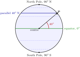
Imagine the Earth cut in two, through both poles, like an apple cut from the stalk downwards. On the cut face (left, below), the equator is the horizontal line through the centre. A place P on the surface is seen from the centre at a certain angle above or below that line: this angle is its latitude.
Definition 14.1 (Parallel and latitude)
A parallel is a circle drawn round the globe parallel to the equator; all the places on the same parallel are at the same distance from the equator. The latitude of a place is the angle, measured at the centre of the Earth, between the equator and that place. It goes from at the equator to at the poles, and we say whether the place is north (N) or south (S) of the equator.
The equator is itself a parallel, the longest one, with latitude . The parallels get shorter towards the poles, and each pole is a single point, at N or S. Along a line from a pole to the equator, each degree of latitude measures about .
Latitude is the easy number: it can be found from the sky. By day, sailors measured the height of the Sun at noon; at night, in the northern hemisphere, they measured the height of the Pole Star. That is what the navigator of the opening picture is doing.
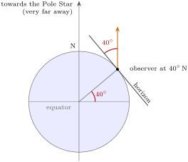
The Pole Star sits almost exactly on the line of the Earth’s axis, prolonged beyond the North Pole, and so far away that its light reaches every place on the Earth along parallel lines. At the North Pole it is straight overhead, at above the horizon; at the equator it lies on the northern horizon, at . In between, the rule is simple: the height of the Pole Star above the northern horizon, measured as an angle, is equal to the latitude. The figure below shows why the two angles are the same.
Example 14.2 (A navigator at night)
A navigator measures the Pole Star at above the northern horizon. The ship is at latitude N, about km north of the equator. Sailing north, she finds the star a little higher each night; sailing south towards the equator, it sinks towards the horizon. South of the equator the Pole Star cannot be seen at all, since it stays below the horizon: there, the noon Sun gives the latitude.
14.2 Meridians and longitude
The second number tells how far east or west a place lies. Here there is no natural starting line like the equator: one has to be chosen.
Definition 14.3 (Meridian, longitude and prime meridian)
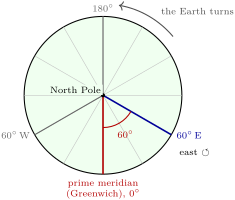
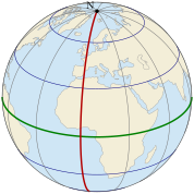
A meridian is a half-circle drawn on the globe from the North Pole to the South Pole. The prime meridian is the meridian chosen as the starting line: the one that passes through the old Royal Observatory at Greenwich, in London. The longitude of a place is the angle between the prime meridian and the meridian of that place, seen from the axis of the Earth. It goes from at the prime meridian to , and we say whether the place is east (E) or west (W) of the prime meridian.
All the meridians meet at the poles, and they all have the same length. On the opposite side of the Earth from Greenwich, the meridian E and the meridian W are the same line.
History — Choosing the prime meridian
For a long time, each country drew its maps with its own starting meridian: London, Paris and other places were all used. In October 1884, delegates of many countries met in Washington to choose one meridian for the whole world. On 13 October, they voted to propose the meridian passing through the observatory of Greenwich: 21 countries voted for it, one against, and two did not vote.
14.3 Finding a place by its two angles
With its latitude and its longitude, any place on the Earth can be found, on a map or on a globe. We write the latitude first: Cairo, for example, is at about N, E.
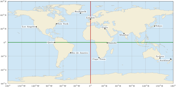
Method 14.4 (Locating a place by its coordinates)
- Latitude: start from the equator and go north (N) or south (S), counting the parallels, up to the right number of degrees.
- Longitude: start from the prime meridian and go east (E) or west (W), counting the meridians, up to the right number of degrees.
- The place is where the parallel and the meridian cross. Between two lines of the grid, estimate: halfway between and is .
Example 14.5 (Reading the coordinates of Sydney)
On the map, Sydney lies below the equator: it is in the southern hemisphere, a little above the parallel S, closer to than to ; its latitude is about S. It lies to the right of the prime meridian, a little beyond the meridian E; its longitude is about E. We write: Sydney, S, E.
14.4 The turning Earth and the time zones
The Earth turns on itself once a day, from west to east. As it turns, the Sun seems to cross the sky from east to west. When the Sun is at its highest in the sky, it is noon. But it is not noon everywhere at the same moment: when it is noon in London, it is already afternoon in Cairo, further east, and still morning in New York, further west.
How much does the Earth turn in one hour? A whole turn is , and it takes 24 hours:
So two places of longitude apart have their noon one hour apart: the place further east has it first. One degree takes 4 minutes.
Definition 14.6 (Time zone)
A time zone is a band of the Earth, from pole to pole, where all the clocks show the same time. Ideally, each zone is of longitude wide, so that there are 24 zones, one for each hour; going one zone to the east, the clocks show one hour more.
In the ideal zones, the zone of a place is its longitude divided by , rounded to the nearest whole number: east of Greenwich we add that many hours to the time at Greenwich, west of it we subtract them. Tokyo, at E: , so the zone is : when it is noon at Greenwich, it is 9 p.m. in Tokyo. Real time zones are not straight bands: they follow the borders of countries and regions, so that a whole country, or a whole region, keeps the same time.
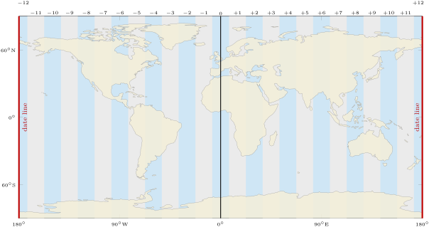
The date line. Travel east from Greenwich, adding one hour per zone: at you are 12 hours ahead. Travel west, subtracting one hour per zone: at you are 12 hours behind. The two travellers meet on the same meridian with clocks showing the same hour, but a whole day apart! One of them must change the date.
Definition 14.7 (International date line)
The international date line is the line, in the middle of the Pacific Ocean, where the date changes. It follows the meridian, with a few bends so as not to cut a country in two. Crossing it towards the west, we move to the next day; crossing it towards the east, we go back to the day before.
History — Harrison’s sea watch
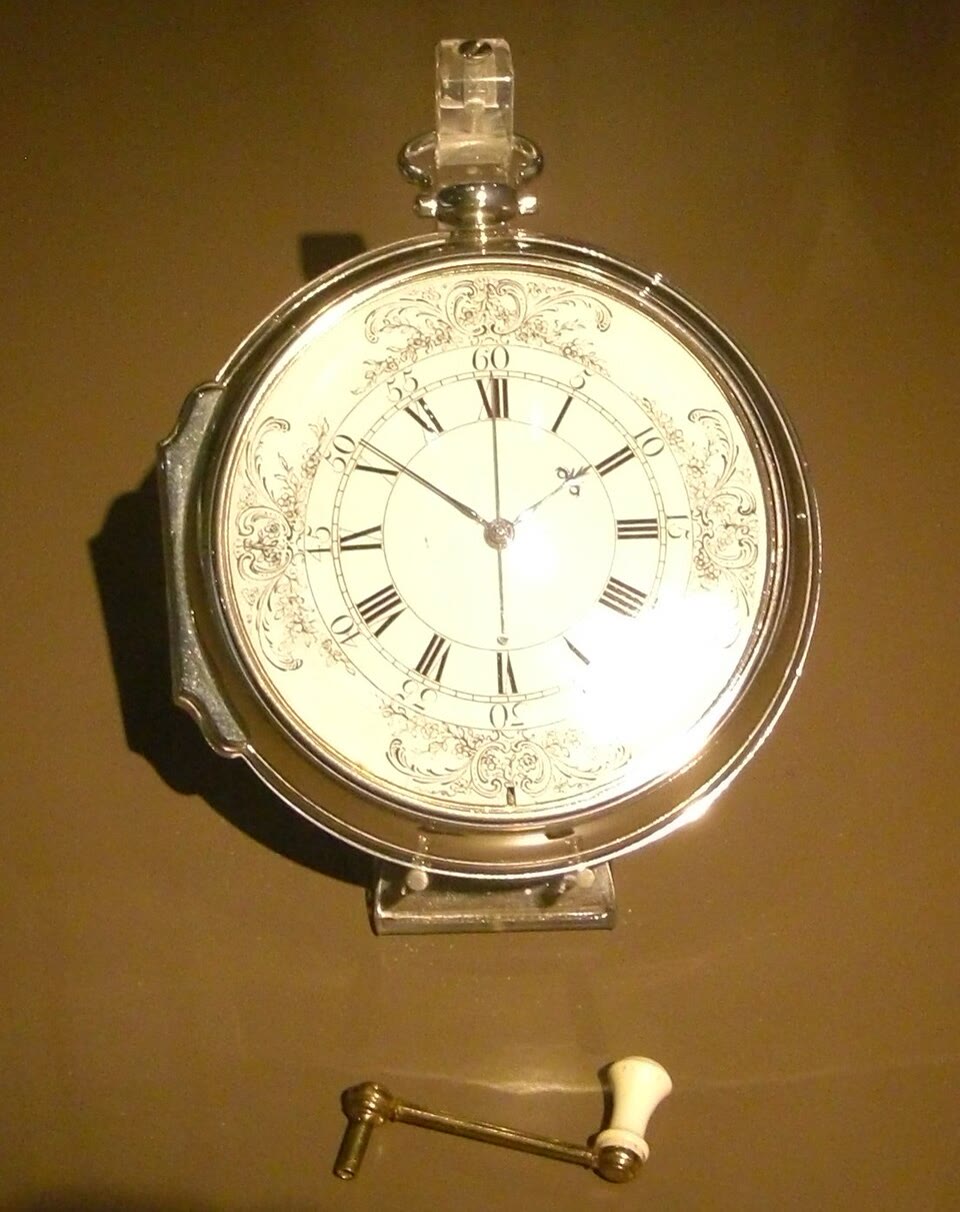
To find his longitude, a navigator compares two times: the local time on the ship, read from the Sun, and at the same moment the time at a home port. Each hour of difference means of longitude. The difficulty was to carry the home time across the ocean: even the best watches of the time were not accurate enough. The English clockmaker John Harrison spent decades on the problem, aiming at a clock that would not gain or lose more than 3 seconds a day. His fourth sea timekeeper, called H4, looks like a large pocket watch and ticks five times a second. In 1761, his son William took it on a voyage to Jamaica to test it.
14.5 Exercises
Exercise 14.1 ★
Copy and complete: “Latitude is measured from the … and goes from to …; longitude is measured from the … meridian and goes from to …”
Solution
Solution of Exercise 14.1.
“Latitude is measured from the equator and goes from to (north or south); longitude is measured from the prime meridian and goes from to (east or west).”
Exercise 14.2 ★
What is the latitude of the North Pole? Of the South Pole? Of a town on the equator?
Exercise 14.3 ★
Using the map of the thirteen cities, say in which hemisphere, northern or southern, and on which side of the prime meridian, east or west, each of these cities lies: Sydney, New York, Cairo, Rio de Janeiro.
Solution
Solution of Exercise 14.3.
Sydney: southern hemisphere, east. New York: northern hemisphere, west. Cairo: northern hemisphere, east. Rio de Janeiro: southern hemisphere, west.
Exercise 14.4 ★
True or false? Correct the false sentences. (a) All the meridians meet at the poles. (b) All the parallels have the same length. (c) The equator is a parallel. (d) The prime meridian passes through Paris.
Exercise 14.5 ★★
Using the map of the thirteen cities, which city lies at about N, E? Which one at about N, W? Give the approximate coordinates of Tokyo.
Exercise 14.6 ★★
Town A is at longitude and town B at longitude E. How many hours apart are their noons? In which town is it noon first?
Solution
Solution of Exercise 14.6.
: their noons are 3 hours apart. It is noon first in town B, which is further east.
Exercise 14.7 ★★
Mumbai is at about E. Work out its ideal time zone. When it is noon at Greenwich, what time is it in Mumbai, in the ideal zones?
Solution
Solution of Exercise 14.7.
, rounded to 5: the zone is . When it is noon at Greenwich, it is , that is 5 p.m., in Mumbai.
Exercise 14.8 ★★
Each degree of latitude measures about . How far from the equator is a town at N, measured along its meridian? How far is the North Pole from the equator?
Exercise 14.9 ★★
New York is in the zone and Tokyo in the zone . How many hours apart are their clocks? When it is 8 a.m. on Monday in New York, what time and what day is it in Tokyo?
Solution
Solution of Exercise 14.9.
hours apart. : it is 10 p.m. on Monday in Tokyo.
Exercise 14.10 ★★
Lena says: “The Sun rises in the east, so the towns in the east see the Sun rise before the towns in the west.” Is she right? Explain with the turning of the Earth.
Solution
Solution of Exercise 14.10.
She is right. The Earth turns from west to east, so the towns in the east are carried towards the Sun first: they see it rise, reach its highest point and set before the towns further west.
Exercise 14.11 ★★★
A ship’s clock gains 3 seconds a day (it runs too fast). (a) How many seconds fast is it after a voyage of 42 days? (b) The Earth turns one degree in 4 minutes, that is 240 seconds. What error, in degrees of longitude, does the clock’s error make? (c) At the equator, one degree of longitude measures about . About how many kilometres is the navigator wrong, at the equator?
Exercise 14.12 ★★★
A plane leaves Tokyo (zone ) at 6 p.m. on Monday and flies east across the Pacific to Los Angeles (zone ). The flight lasts 10 hours. (a) What time is it at Greenwich when the plane leaves? (b) What time is it at Greenwich when it lands? (c) What is the local time and the day in Los Angeles when it lands? Why do travellers say that on this flight “you land before you took off”?
Solution
Solution of Exercise 14.12.
(a) : 9 a.m. on Monday at Greenwich. (b) : 7 p.m. on Monday at Greenwich. (c) : 11 a.m. on Monday in Los Angeles. The plane left at 6 p.m. on Monday (Tokyo time) and lands at 11 a.m. on the same Monday (Los Angeles time): the clocks at arrival show an earlier time than the clocks at departure, because the plane crossed the date line towards the east and went back one day.
14.6 Problem: A video call around the world
Problem 14.1
Weekend problem — five friends, four time zones and one date line: what time is it in Auckland when the call starts?
Lena lives in London. She wants to organise a video call with four friends she met on holiday: Ana in Rio de Janeiro, Kenji in Tokyo, Mia in Auckland and Sam in Los Angeles. In this problem, we use the ideal time zones.
| friend | city | coordinates |
|---|---|---|
| Lena | London | N, |
| Ana | Rio de Janeiro | S, W |
| Kenji | Tokyo | N, E |
| Mia | Auckland | S, E |
| Sam | Los Angeles | N, W |
Part I — Where the friends live.
- Which friends live in the southern hemisphere?
- Which friends live west of the prime meridian?
- Which friend lives farthest from the equator?
- Which friend lives closest to the meridian? How many degrees of longitude away from it?
Part II — What time is it?
- How many degrees does the Earth turn in one hour?
- Work out the ideal time zone of each friend’s city.
- Lena proposes to start the call on Friday at 8 p.m., London time. What time and what day is it then in Rio de Janeiro? In Tokyo?
- Kenji answers that he will be asleep. Explain why it is already Saturday in Tokyo.
Part III — Crossing the date line.
- What time and what day is it in Los Angeles when the call starts?
- How many hours ahead of Los Angeles are the clocks of Auckland?
- Sailing east from Auckland to Los Angeles, a ship crosses the date line. Does it go forward to the next day or back to the day before?
- What is the local time, and the day, in Auckland when the call starts?
Solution
Solution of Problem 14.1.
1. Ana (Rio de Janeiro, S) and Mia (Auckland, S).
2. Ana and Sam ( W and W). Lena is on the prime meridian.
3. Lena: London is at N, farther from the equator than all the others.
4. Mia: Auckland is at E, only degrees from the meridian.
5. .
6. London: . Rio de Janeiro: , west, so . Tokyo: , east, so . Auckland: , east, so . Los Angeles: , west, so .
7. Rio de Janeiro: , 5 p.m. on Friday. Tokyo: ; : 5 a.m. on Saturday.
8. Tokyo is far to the east: its clocks are 9 hours ahead of London’s. At 8 p.m. in London, Tokyo has already passed midnight, so its Saturday has begun.
9. : noon on Friday.
10. hours ahead.
11. Crossing the date line towards the east, the ship goes back to the day before.
12. ; : when the call starts, it is 8 a.m. on Saturday in Auckland. Mia joins the call at breakfast time, while Sam has his lunch on Friday.