বইগুলো এখনো বাংলা ভাষায় পাওয়া যায় না — ইংরেজি সংস্করণ দেখানো হচ্ছে।
Primary & Middle School Earth and Space Sciences · শ্রেণি 1–9
4From a Drawing to a Map
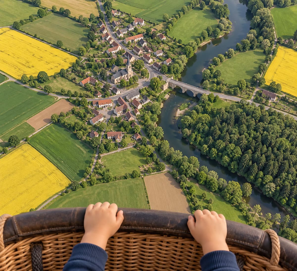
A pigeon flies over the school. What does it see? Not the front doors, not the windows, not the children’s faces: from up there it sees only the tops of things. The roofs of the buildings are grey rectangles. The yard is a big empty shape with a few round treetops. The paths are thin lines. The pigeon sees the school from above — the way a map shows it.
4.1 Seen from the side, seen from above
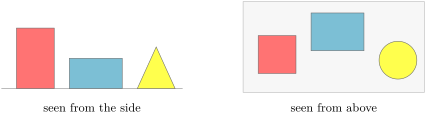
Put a few toy blocks on a table. Look at them from the side: you see their height, and the ones at the back are hidden behind the ones in front. Now stand up and look down on them from above: you no longer see how tall they are, but you see exactly where each one is, and how far apart they are.
Definition 4.1 (Plan)
A plan is a drawing of a small place — a room, a house, a school, a garden — as it is seen from straight above, drawn smaller than it really is but with every part in its right place.
4.2 Drawing smaller: the scale
A classroom is far too big to draw on a sheet of paper as it is. We draw it smaller — but every part must be smaller in the same way, or the plan will lie. The easiest way is to use squared paper: one square of the paper stands for one metre of the classroom.
Definition 4.2 (Scale)
The scale of a plan or a map tells how much smaller the drawing is than the real place: how far on the ground a length on the drawing stands for. For example: 1 square stands for 1 metre.
Method 4.3 (Measuring on a plan)
To find a real length on a plan drawn on squares:
Example 4.4 (How long is the classroom?)
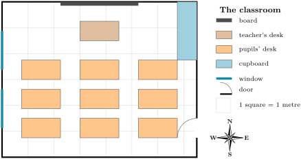
Along the north wall of the plan there are 10 squares. One square stands for 1 metre, so the classroom is 10 metres long. Along the west wall there are 8 squares: it is 8 metres wide. The board covers 4 squares of the north wall: it is 4 metres long.
4.3 From a plan to a map
A plan shows a small place. When we draw a bigger place — a whole town, a valley, a country — we draw a map.
Definition 4.5 (Map)
A map is a drawing of a large part of the Earth’s surface, seen from above and drawn much smaller than it really is.
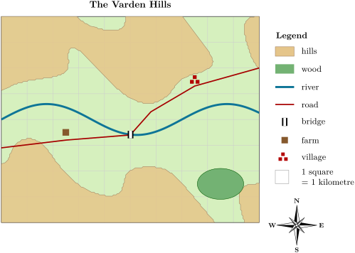
On a map, a house is far too small to draw as it really is, so map makers use small signs: a dot for a farm, a blue line for a river, a green shape for a wood. The meaning of every sign is given in a box beside the map.
Definition 4.6 (Legend)
A map symbol is a small sign that stands for one kind of thing on a plan or a map. The legend is the box that shows every symbol of the map with its meaning.
4.4 Finding our way: the four directions and the compass rose
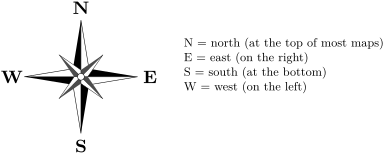
To say where something is, “on the left” or “on the right” is not enough: what is on your left is on the right of someone facing you. People use four directions that are the same for everybody: north, east, south and west. You have met them in the physics books, with the compass. In the morning the Sun rises in the east, and in the evening it sets in the west; north and south are halfway between them, opposite each other.
Definition 4.7 (Compass rose)
A compass rose is the star drawn on a map that shows the directions north, east, south and west. On most maps north is at the top, east on the right, south at the bottom and west on the left.
Safety
Never look at the Sun to find east or west: it can hurt your eyes for ever. Look at the shadows instead, or use a compass.
4.5 Reading a real map
Every good map has four parts: a title that says what the map shows, a legend, a scale, and a compass rose (or at least an arrow pointing north). Here is the map of a hilly valley, the Varden Hills. It is the invented valley that you will meet again and again in this book and in the next ones, each time drawn in more detail.
Method 4.8 (Reading a map)
- Read the title: what place does the map show?
- Read the legend: what does each symbol mean?
- Find the compass rose: where is north?
- Read the scale, and count squares to find distances.
Example 4.9 (From the farm to the village)
On the map of the Varden Hills, the farm is south of the river. To go to the village, the farmer takes the road eastwards, crosses the river on the bridge, and goes on to the north-east. The village is 5 squares east of the farm and 2 squares north of it: that is 5 kilometres to the east and 2 kilometres to the north.
4.6 Exercises
Exercise 4.1 ★
Is a plan drawn as seen from the side, or as seen from above?
Solution
Solution of Exercise 4.1.
As seen from above.
Exercise 4.2 ★
On the plan of the classroom, what is drawn in blue on the west wall? What is in the north-east corner?
Solution
Solution of Exercise 4.2.
The blue lines on the west wall are the windows. In the north-east corner there is the cupboard.
Exercise 4.3 ★
Name the four parts that every good map should have.
Solution
Solution of Exercise 4.3.
A title, a legend, a scale and a compass rose (or an arrow pointing north).
Exercise 4.4 ★
On most maps, which direction is at the top? Which is on the left?
Solution
Solution of Exercise 4.4.
North is at the top; west is on the left.
Exercise 4.5 ★
On the plan of the classroom, a pupils’ desk covers 2 squares by 1 square. How long and how wide is a desk in the real classroom?
Solution
Solution of Exercise 4.5.
One square stands for 1 metre: the desk is 2 metres long and 1 metre wide.
Exercise 4.6 ★
On the map of the Varden Hills, what does the brown square stand for? And the green shape?
Solution
Solution of Exercise 4.6.
The brown square is the farm; the green shape is the wood.
Exercise 4.7 ★★
On the map of the Varden Hills, is the wood north or south of the river? Is it east or west of the farm?
Exercise 4.8 ★★
On the map of the Varden Hills, the whole map is 10 squares from west to east and 8 squares from south to north. How many kilometres is that in each direction?
Solution
Solution of Exercise 4.8.
One square stands for 1 kilometre: 10 kilometres from west to east and 8 kilometres from south to north.
Exercise 4.9 ★★
On the classroom plan, how many pupils’ desks are there? A pupil sits at the desk nearest to the door. Is it in the north or in the south of the classroom?
Solution
Solution of Exercise 4.9.
Three rows of three desks: 9 desks. The door is in the south part of the east wall, so the desk nearest to the door is in the south (the south-east corner of the room).
Exercise 4.10 ★★
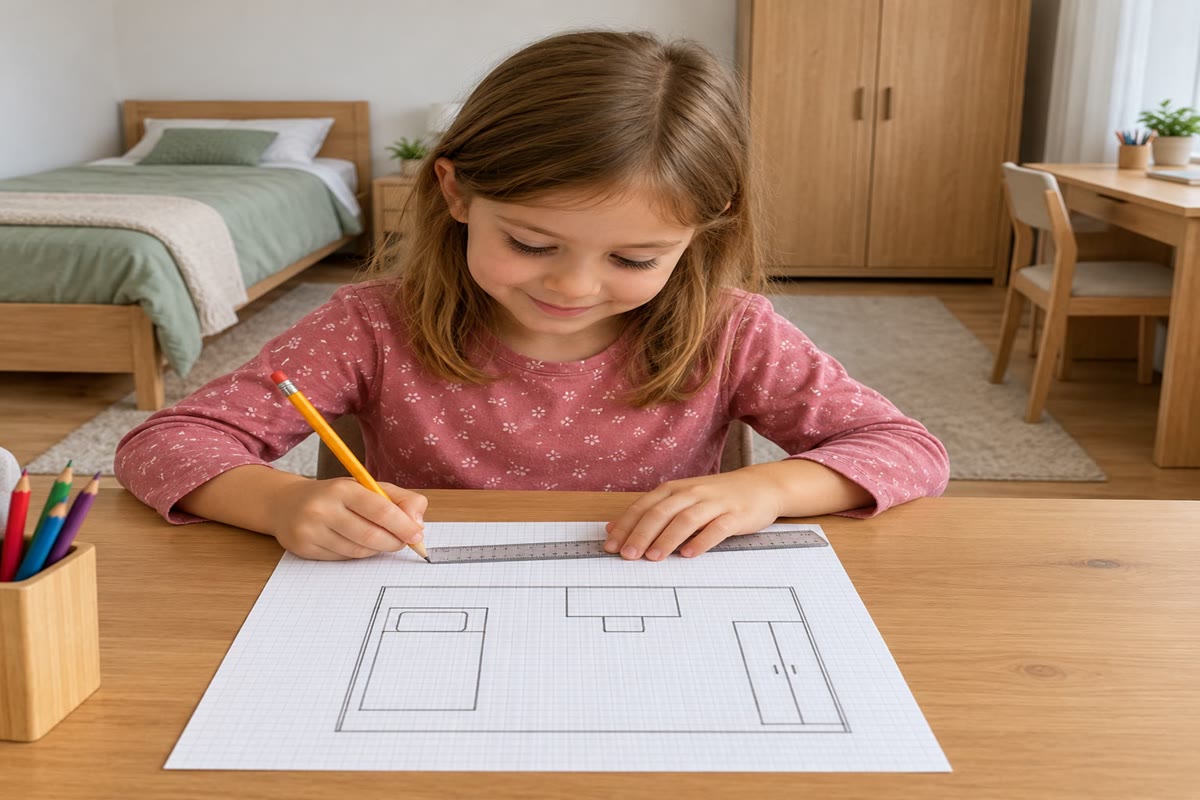
Lucas draws a plan of his bedroom. His bed is 2 metres long. With the scale “1 square stands for 1 metre”, how many squares long is the bed on his plan? His bedroom is 4 metres long and 3 metres wide: how many squares does the whole room cover?
Solution
Solution of Exercise 4.10.
The bed is 2 squares long. The room is 4 squares by 3 squares: 3 rows of 4 squares, that is squares.
Exercise 4.11 ★★
Lena says: “The river is on my left.” Why does this not tell us where the river is? Say it again in a way that is true for everybody, if she stands on the farm of the Varden Hills.