বইগুলো এখনো বাংলা ভাষায় পাওয়া যায় না — ইংরেজি সংস্করণ দেখানো হচ্ছে।
Primary & Middle School Earth and Space Sciences · শ্রেণি 1–9
19Volcanoes
On 17 May 1980, a geologist stood on a ridge ten kilometres from Mount St. Helens, in the north-west of the United States, and took the photograph on the left below: a smooth, snowy cone, one of the most graceful mountains of the country. For two months the mountain had been trembling, and its north side had been swelling outwards like a balloon. The next morning, at 8:32, a small earthquake shook it. The whole swollen side slid away, and the volcano exploded sideways. When the same ridge could be photographed again, in September, the mountain looked like the photograph on the right.
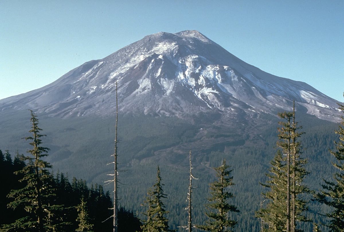
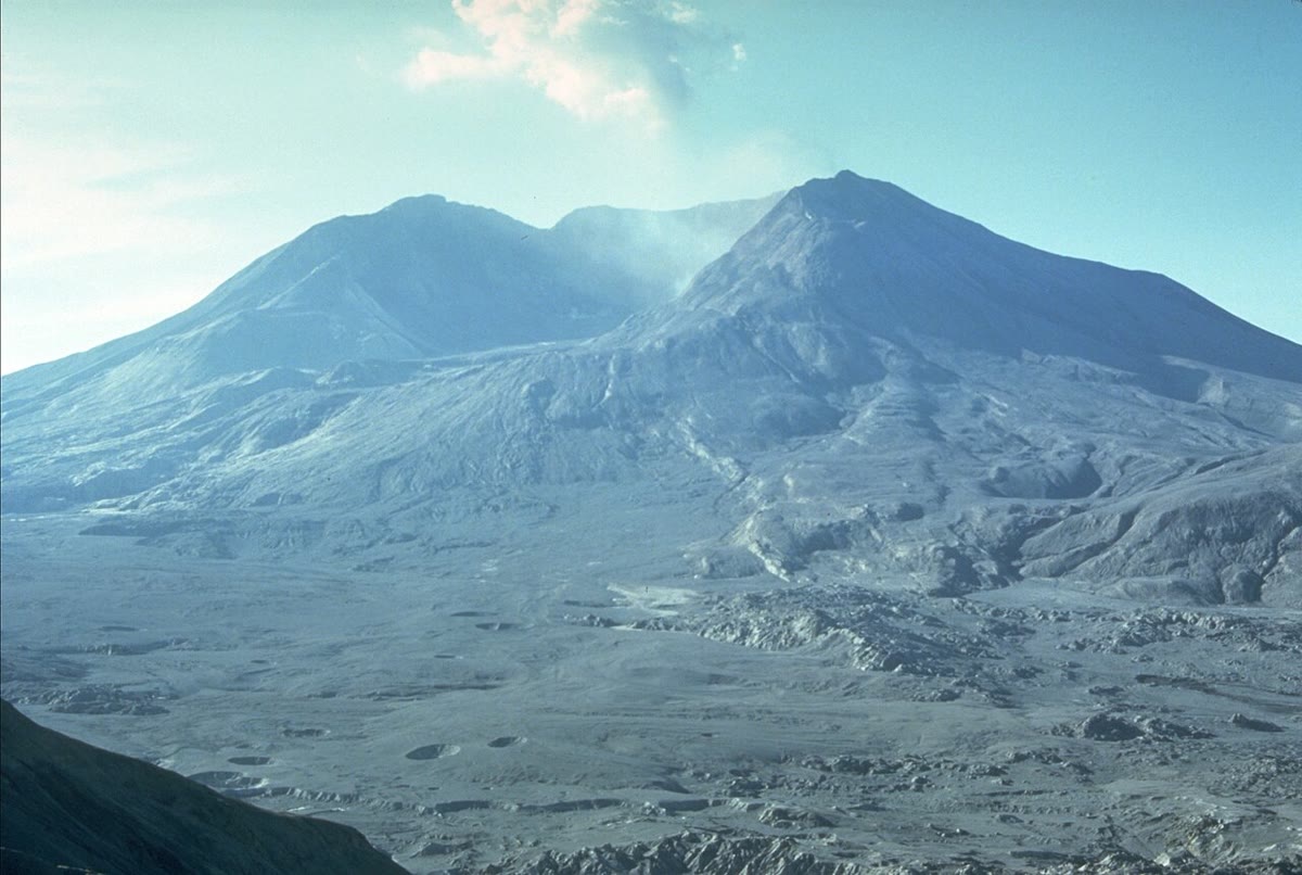
In this chapter we open a volcano up, to see what drives an eruption; we find out why some volcanoes pour out quiet rivers of lava while others blow themselves apart; and we look at the world map again, to see where the volcanoes are and why.
You already know
A volcano is a place where molten rock from deep inside the Earth comes out at the surface, and the hill or mountain that it builds there. During an eruption it throws out lava, ash and gas (Chapter 8). Below the crust, the mantle is made of hot rock which is solid, although it can creep very slowly (Chapter 16). Basalt and granite are igneous rocks: they form when molten rock cools and hardens (Chapter 15). The outer shell of the Earth is broken into plates which move a few centimetres a year; their edges are the plate boundaries (Chapter 18).
19.1 Inside a volcano
The mantle is solid. Yet in a few places, deep under the surface, a small part of the rock melts. The molten rock is lighter than the solid rock around it, so it rises slowly, squeezing up through cracks, like a drop of oil rising through water.
Definition 19.1 (Magma)
Magma is molten rock underground. It is a hot liquid which may also carry crystals and, dissolved in it, gases such as water vapour and carbon dioxide. Magma that comes out at the surface is called lava; as it comes out, it loses most of its gas.
Rising magma often stops on its way, a few kilometres below the surface, where it gathers in a large pocket. There it waits, sometimes for centuries, before an eruption empties part of it.
Definition 19.2 (Magma chamber)
A magma chamber is a large space in the rocks under a volcano, a few kilometres down, where magma gathers before an eruption.
Definition 19.3 (Vent and crater)
A vent is an opening at the surface through which magma, gas and ash come out. A crater is the bowl-shaped hollow around a vent, usually at the top of the volcano.
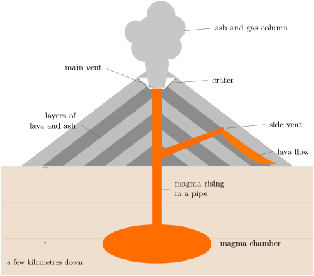
So the same molten rock has two names. Underground it is magma; once it has come out of a vent, it is lava. The difference is not only a matter of words: magma still holds its gas, while lava has lost most of it into the air. We shall see that this gas decides what kind of eruption a volcano has.
How hot is it? Scientists of the Hawaiian Volcano Observatory measure the lava as it comes out of the vents of Kilauea, one of the volcanoes of Hawaii: about . Hot rock glows, and the colour of the glow depends on its temperature: special cameras read the temperature of a flow from far away by measuring the colours of its glow. Even the eye gets a rough idea, as the table shows.
| colour of the glowing rock | temperature |
|---|---|
| yellow | about 1000 to |
| orange | about 800 to |
| red | about 600 to |
Remark 19.4 (A skin that cools in a second)
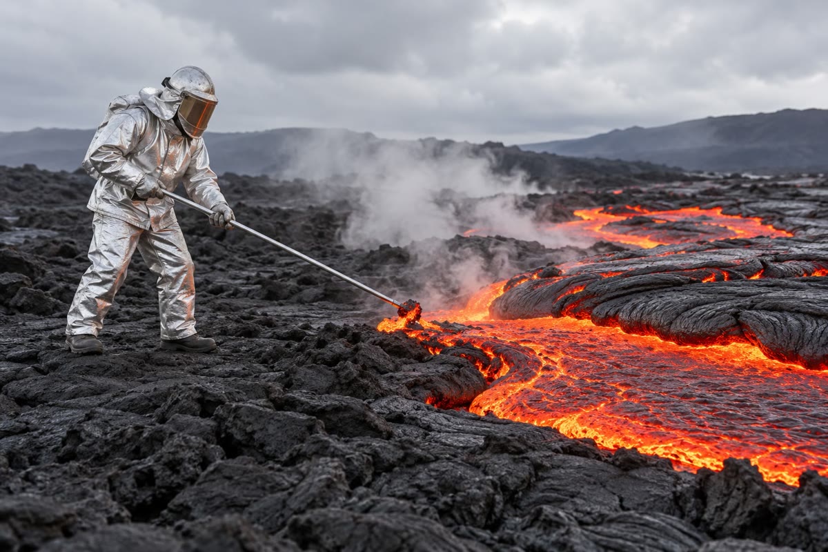
When lava first meets the air, its surface cools by hundreds of degrees every second: a dark skin forms at once on the glowing rock. Under the skin the lava stays hot for a long time. In Hawaii, lava has flowed in tunnels under its own hardened roof for , from a vent to the sea, and still reached the shore at about : only about 30 degrees cooler than at the vent.
19.2 Two ways to erupt
Mount St. Helens blew itself apart. The volcanoes of Hawaii, on the contrary, usually pour out lava which flows away down their slopes. Geologists sort eruptions into two kinds.
Definition 19.5 (Effusive and explosive eruptions)
In an effusive eruption the magma comes out quietly as lava, which flows away from the vent, sometimes for kilometres, or spurts up in fountains of glowing drops. In an explosive eruption the magma is blown to pieces by its own gas: a column of ash, gas and lumps of rock is thrown high into the sky.
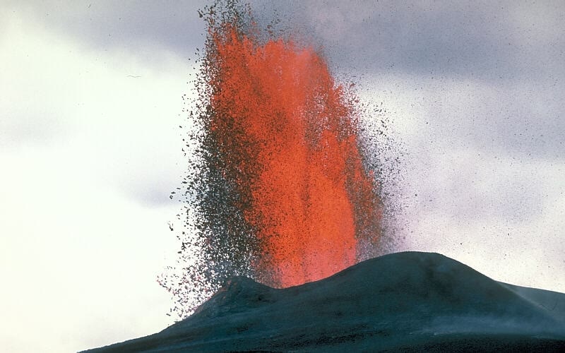
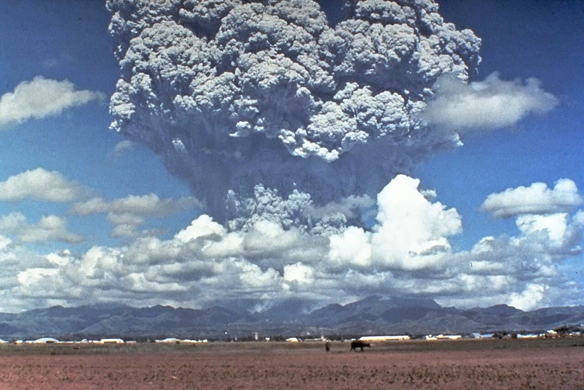
What makes the difference? Two things: how runny the magma is, and how much gas it holds.
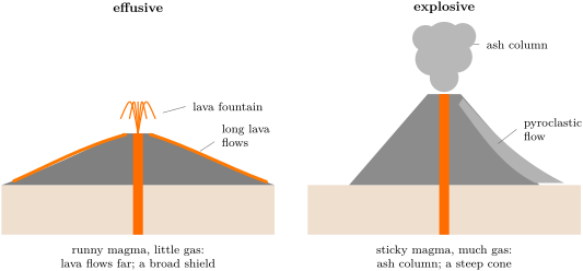
Runny or sticky. Some magma is runny, almost like warm honey: this is the case of the magma that cools into dark basalt, as in Hawaii. Other magma is thick and sticky, like cold honey or toothpaste. Through runny magma, gas bubbles rise easily and escape at the surface, a few at a time. In sticky magma the bubbles are trapped.
Little or much gas. A bottle of fizzy water holds a lot of gas dissolved in the water, kept there by the pressure inside the closed bottle; you cannot see it. Open the bottle and the pressure drops: bubbles appear everywhere, and if the bottle has been shaken, the foam bursts out. Magma deep underground also holds gas dissolved under high pressure. As it rises, the pressure drops and the gas comes out of solution as bubbles.
Put the two together. Runny magma with little gas lets its bubbles go and comes out as flowing lava: the eruption is effusive. Sticky magma full of gas keeps its bubbles until they swell so much that they tear the magma into shreds: the eruption is explosive. The shreds of frothy magma freeze in the air into ash and into pumice, a rock so full of bubbles that it can float.
Example 19.6 (Pinatubo, 1991: the flat soda and the shaken one)
In June 1991 the first magma reached the surface of Mount Pinatubo, in the Philippines. On its way up it had lost most of its gas, “like a bottle of soda pop gone flat”, in the words of the scientists who were watching. It oozed out slowly and piled up into a mound over the vent: no explosion. Then, on 12 June, magma still full of gas reached the surface and exploded — the column in the photograph above. On 15 June, even more gas-rich magma arrived, and the volcano had one of the largest eruptions of the twentieth century: it threw out more than five cubic kilometres of rock and ash, its ash cloud rose high, and the top of the mountain collapsed into a hollow across. The same volcano, the same week: the gas made the difference.
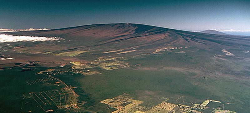
The shape of a volcano keeps the memory of its eruptions. Runny lava flows far before it hardens, so layer after layer it builds a broad mountain with gentle slopes, shaped like a warrior’s shield lying on the ground: a shield volcano. Mauna Loa, in Hawaii, is one. Sticky lava and ash pile up close to the vent, into a steep cone made of layers of lava and ash: a stratovolcano (strata means layers). Mount St. Helens and Pinatubo are two of them.
Method 19.7 (Effusive or explosive? Four clues)
To tell from a description or a photograph which kind of eruption a volcano has, look for these clues.
- What comes out? Lava flowing or spurting in fountains: effusive. A column of ash, lumps of rock thrown out: explosive.
- The shape of the volcano. A broad mountain with gentle slopes: mostly effusive eruptions. A steep cone: often explosive.
- The magma. Runny, little gas: effusive. Sticky, much gas: explosive.
- The rocks left behind. Dark, solid lava flows: effusive. Layers of ash and pumice: explosive.
Example 19.8 (Using the clues)
A traveller describes a volcano: “a huge, gently rounded mountain, black lava flows everywhere on its slopes, some of them only a few years old”. Clue 2 (gentle slopes) and clue 4 (dark lava flows) both point to effusive eruptions: it is a shield volcano, like Mauna Loa.
In the lab — A volcano in a bottle (in class, with the teacher)
The teacher takes two closed bottles of fizzy water. One has been left standing; the other has been gently shaken. Both are opened outdoors, over a basin, pointing away from everyone. The still bottle hisses and lets a few bubbles rise; the shaken one bursts into foam that shoots out. Which bottle is like the magma of Hawaii, which like Pinatubo’s? Then drop a piece of pumice and a pebble into a bowl of water: the pumice floats. Look at it through a magnifying glass: it is full of holes, the bubbles of gas frozen into the rock as the magma burst.
19.3 What comes out of a volcano
An eruption throws out much more than lava: gases, ash, lumps of rock and, in the worst cases, avalanches of hot ash.
The most abundant gas, by far, is water vapour. Large eruptions release huge amounts of gas in a short time: on a single day of 1991, Pinatubo is thought to have sent more than 250 million tonnes of gas into the upper atmosphere.
Definition 19.9 (Pyroclastic flow)
A pyroclastic flow is a fast avalanche of hot gas, ash and pieces of rock, from grains of dust to boulders, which rushes down the slopes of a volcano during an explosive eruption. (Pyro means fire and clastic means made of broken pieces.)
Pyroclastic flows usually move faster than , and the rocks and gas inside them are generally between 200 and . They generally follow the valleys, like water, and knock down, burn or bury nearly everything in their path. On 18 May 1980, the pyroclastic flows of Mount St. Helens raced at 80 to , at a temperature of at least , and reached from the crater.
The table sums up the products of a volcano.
| product | what it is | the danger |
|---|---|---|
| lava flow | molten rock flowing on the ground, then hardening | burns and buries what it meets, but usually slow enough for people to move out of the way |
| ash | tiny pieces of rock and glass, blown into the air | falls far away; roofs collapse under its weight; it damages aircraft |
| volcanic bombs | lumps of lava thrown out, which harden as they fly | crush what they hit, near the vent |
| gases | mostly water vapour, then carbon dioxide and sulfur dioxide | some are poisonous; carbon dioxide gathers in hollows |
| pyroclastic flow | an avalanche of hot ash, rock and gas | the deadliest: too fast and too hot to escape |
| mudflow | ash and rock mixed with water from rain or melted snow | rushes down valleys, sometimes far from the volcano |
Method 19.10 (How long does it take?)
To find how long something moving at a known speed takes to cover a distance, divide the distance by the speed:
With a distance in kilometres and a speed in kilometres per hour, the time comes out in hours; multiply by 60 to get minutes.
Example 19.11 (Racing a pyroclastic flow)
A pyroclastic flow moving at heads for a village down the valley. It takes hour, that is minutes. Three minutes: nobody can run, or even drive, out of the valley in time. People are only safe if they have left before the eruption.
Remark 19.12 (Mudflows: the danger that comes later)
An eruption leaves the slopes covered with loose ash. When rain falls on it, or when the heat melts the snow and ice of the summit, the ash turns into mudflows that rush down the valleys. On 18 May 1980, the mudflows of Mount St. Helens damaged 27 bridges and nearly 200 homes. Around Pinatubo, the heavy rains of the following years turned the ash into giant mudflows which buried whole villages: they did more damage than the eruption itself.
19.4 Where are the volcanoes?
The Smithsonian Institution, in Washington, keeps a list of all the volcanoes known to have erupted in the last 12 000 years: 1 214 of them, on land and under the sea. For each one the list says where it stands with respect to the plates. The map below colours them in this way.
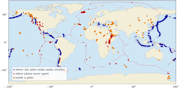

Proposition 19.13 (Most volcanoes stand on plate boundaries)
Of the 1 214 volcanoes active in the last 12 000 years, 838 (69 %) stand where one plate sinks under another and 221 (18 %) where plates move apart; 149 (12 %) stand inside a plate, far from its edges. For the last 6 (0.5 %) the setting is not known.
Where plates move apart. Along the ocean ridges, and in rifts such as the one that is tearing East Africa apart, the plates pull away from each other. Magma rises from the mantle into the widening cracks and fills them: new crust is made. Most of the ridges lie under the sea, but Iceland stands right on the Mid-Atlantic Ridge: there, these volcanoes can be seen on land. Their magma is mostly runny basalt, and their eruptions are mostly effusive.
Where one plate sinks under another. More than two volcanoes in three stand here, along lines that follow the edges of the Pacific Ocean — the “Ring of Fire” — and a few other places. Deep down, along the sinking plate, some of the rock partly melts; scientists still discuss exactly which rock melts, the sinking plate or the plate above it, or both. The magma that rises there is often sticky and full of gas: these are the explosive volcanoes, like Mount St. Helens and Pinatubo. The data show it: of the 660 steep cones (stratovolcanoes) in the list, 564 — that is 85 % — stand where one plate sinks under another.
Inside a plate. A few volcanoes are far from any boundary. The most famous are those of Hawaii, in the middle of the Pacific Ocean, more than from the nearest edge of a plate.
Definition 19.14 (Hotspot)
A hotspot is a place, deep in the mantle, which stays hot for millions of years and keeps feeding magma to volcanoes at the surface, even far from the edges of the plates.
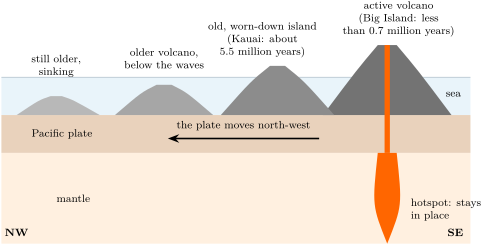
The hotspot stays where it is, while the plate above it moves. A volcano grows above the hotspot; then the moving plate carries it away, and it dies, while a new volcano grows over the hotspot behind it. In time, the plate carries a whole line of volcanoes, the oldest farthest from the hotspot. That is just what we see in Hawaii: the oldest rocks of the island of Kauai, at the north-west end of the inhabited islands, are about 5.5 million years old, and deeply worn down by rain and waves; on the Big Island, at the south-east end, the oldest rocks at the surface are less than 0.7 million years old, and new lava still comes out.
History — A geophysicist and a line of islands
Why should a chain of volcanic islands rise in the middle of the largest plate on Earth? In 1963 the Canadian geophysicist J. Tuzo Wilson proposed an answer. The Hawaiian islands, he suggested, are a line because the Pacific plate moves over a deep, fixed source of heat in the mantle, which partly melts the plate above it. If he was right, the islands should be older and more worn down the farther they are from the active volcanoes of the Big Island. The ages of their rocks show exactly that. A single idea explained both the line and the order of the ages. (Wilson is also the scientist who discovered the transform boundaries, where plates slide past each other.)
19.5 Living with volcanoes
Many people live near volcanoes: about 3 million lived in the region around Pinatubo in 1991. Luckily, a large eruption often gives warning signs. Rising magma pushes the rocks aside: the ground cracks and shakes with small earthquakes, the slopes swell, gas escapes. At Mount St. Helens, the first small earthquakes came on 16 March 1980; by 17 May there had been more than 10 000, and the north side had swollen outwards by at least . Scientists measured all this and the area was closed; even so, 57 people died on 18 May.
At Pinatubo, in 1991, the scientists who watched the earthquakes, the gas and the swelling of the volcano gave the warning in time: people living near the volcano left, and at least 5 000 lives were saved.
Remark 19.15 (Never go near an erupting volcano)
Watching an eruption is only for the places that the authorities have opened to the public. Gases, falling rocks, fresh lava crust that breaks under your feet and pyroclastic flows can kill, often without warning. Volcano observatories publish what is safe to visit: always follow them.
19.6 Exercises
Exercise 19.1 ★
Match each word with its meaning: magma; lava; magma chamber; vent; crater. (a) A bowl-shaped hollow at the top of a volcano. (b) Molten rock underground. (c) An opening through which magma comes out. (d) Molten rock that has come out at the surface. (e) A large pocket of magma a few kilometres under a volcano.
Exercise 19.2 ★
Effusive or explosive? (a) Rivers of glowing lava flow down a gentle slope. (b) A column of ash rises into the sky. (c) A fountain of glowing drops spurts from a crack. (d) An avalanche of hot ash and gas rushes down a valley.
Solution
Solution of Exercise 19.2.
(a) Effusive. (b) Explosive. (c) Effusive: a lava fountain throws out glowing drops which fall back and flow; the magma is not blown into ash. (d) Explosive: it is a pyroclastic flow.
Exercise 19.3 ★
True or false? Correct the false ones. (a) Magma and lava are two names of the same molten rock, underground and at the surface. (b) The most abundant volcanic gas is carbon dioxide. (c) A pyroclastic flow is a river of liquid lava. (d) The Hawaiian volcanoes stand on a plate boundary.
Solution
Solution of Exercise 19.3.
(a) True. (b) False: the most abundant volcanic gas is water vapour; carbon dioxide comes next. (c) False: a pyroclastic flow is an avalanche of hot gas, ash and pieces of rock. (d) False: they stand inside the Pacific plate, more than 3200 km from the nearest boundary, above a hotspot.
Exercise 19.4 ★
Use the table of glow colours. (a) Lava glows yellow: give its temperature. (b) A hardening flow glows dark red: give its temperature. (c) A photograph shows orange lava at the front of a flow and yellow lava near the vent. Where is it hotter? Why?
Exercise 19.5 ★★
Use the bar chart of the 1 214 volcanoes. (a) How many volcanoes stand on a plate boundary (where plates move apart, or where one sinks under another)? (b) What percentage of all the volcanoes is that? (c) Check that the four percentages of the proposition add up to about 100 %.
Solution
Solution of Exercise 19.5.
(a) volcanoes. (b) : about 87 %. (c) , about 100 %: the small difference comes from rounding each percentage.
Exercise 19.6 ★★
Of the 660 steep cones (stratovolcanoes) of the list, 564 stand where one plate sinks under another, 62 where plates move apart and 33 inside a plate. (a) Find the percentage of steep cones that stand where one plate sinks under another. (b) How many steep cones are left for the setting “not known”? (c) Use the four clues: what kind of eruptions should we expect along the Ring of Fire?
Solution
Solution of Exercise 19.6.
(a) : about 85 %. (b) : one steep cone. (c) Steep cones are built by sticky lava and ash, the mark of explosive eruptions: along the Ring of Fire, where one plate sinks under another, we expect many explosive eruptions, like those of Mount St. Helens and Pinatubo.
Exercise 19.7 ★★
At Kilauea, lava leaves the vent at about . In a lava tunnel it reached the sea, away, at about . (a) By how many degrees did it cool? (b) How many degrees is that per kilometre? (c) Lava in the open air cools by hundreds of degrees per second at its surface. Explain why the lava in the tunnel stayed so hot.
Solution
Solution of Exercise 19.7.
(a) degrees. (b) degrees per kilometre. (c) In the tunnel the lava does not touch the air: the hardened roof above it keeps the heat in, like the lid of a pot. In the open, its surface loses heat to the air at once.
Exercise 19.8 ★★
The oldest rocks of Kauai are about 5.5 million years old; those of the Big Island, less than 0.7 million years old. (a) Which island is older? By at least how many million years? (b) Which island is more worn down? Why? (c) Which island stands over the hotspot today? (d) Kauai lies north-west of the Big Island. In which direction does the Pacific plate carry the islands?
Exercise 19.9 ★★
The Hawaiian islands are more than from the nearest plate boundary. (a) Why is that surprising for volcanoes? (b) Explain in three or four sentences where their magma comes from. (c) On the map of the volcanoes, which colour are they?
Solution
Solution of Exercise 19.9.
(a) Almost all volcanoes stand on plate boundaries (87 % in the list): volcanoes so far from any boundary are an exception. (b) Deep in the mantle under Hawaii, a hotspot stays hot for millions of years. It partly melts the rock above it. The magma, lighter than the solid rock around it, rises through the plate and erupts. As the plate moves, new volcanoes grow over the hotspot and the old ones are carried away. (c) Orange dots (“inside a plate”).
Exercise 19.10 ★★
In June 1991 the first magma of Pinatubo oozed out quietly; three days later, other magma exploded. Using the two bottles of fizzy water, explain the difference. Which of the two magmas had lost its gas on the way up?
Solution
Solution of Exercise 19.10.
The first magma had lost most of its gas on the way up, like a bottle of fizzy water left open or left standing: when it reached the surface, nothing was left to blow it apart, and it oozed out. The magma of 12 and 15 June still held its gas, like the shaken bottle: as the pressure dropped near the surface, the gas formed bubbles all at once, which swelled and tore the sticky magma into ash. The first magma is the one that had lost its gas.
Exercise 19.11 ★★★
A village stands down a valley from a volcano. (a) A pyroclastic flow moves at . How many minutes would it take to reach the village? (b) Same question at . (c) A family needs 20 minutes to leave by car. Explain why the warning has to come before the eruption starts, not when the flow is seen.
Solution
Solution of Exercise 19.11.
(a) hour, and minutes. (b) hour, about minutes, so about 5 minutes. (c) The family needs 20 minutes, but the flow arrives in 5 to 8 minutes: once the flow is seen, it is too late. The family can only be safe if it leaves when the scientists see the warning signs, before the eruption.
Exercise 19.12 ★★★
The ash of Mount St. Helens went once around the whole Earth in 15 days. One degree of latitude is about , and a full turn is 360 degrees. (a) About how long is a full turn of the Earth, in kilometres? Round to the nearest thousand. (b) How many kilometres did the ash travel per day, on average? (c) How many kilometres per hour is that? (d) Is the ash carried by the wind or by its own speed? Explain.
Solution
Solution of Exercise 19.12.
(a) : about 40 000 km. (b) : about 2 670 km per day. (c) : about 110 km per hour. (d) By the wind: the fine ash has no speed of its own once the eruption has thrown it up; it floats high in the air and the wind carries it, while it slowly falls.
19.7 Problem: The day the mountain lost its top
Problem 19.1
Weekend problem — the warning signs of Mount St. Helens, the eruption of 18 May 1980, and how much of the mountain was gone
Mount St. Helens stands in the north-west of the United States. Use the photographs at the start of the chapter, the map of the volcanoes and the numbers below, measured by the U.S. Geological Survey.
Part I — Before the eruption.
- The first small earthquakes came on 16 March 1980; the great eruption on 18 May. How many days passed between the two? (March has 31 days, April 30.)
- By 17 May, more than 10 000 earthquakes had been recorded, in the 62 days since 16 March. About how many is that per day, on average?
- The north side of the mountain swelled outwards by at least . Explain why the swelling worried the scientists.
- On the map of the volcanoes, Mount St. Helens is a blue triangle. What does that tell you about its setting? Which kind of eruption do you expect, and which shape of volcano?
Part II — 18 May 1980.
- At 8:32 a small earthquake set the swollen side sliding. The landslide moved at up to . How many kilometres is that per minute?
- The landslide uncovered the magma like a cork pulled from a shaken bottle. Explain why the volcano then exploded sideways.
- The sideways blast moved at least and reached from the volcano. At that speed, how many minutes did it take, at most, to get there?
- The pyroclastic flows moved at up to and reached from the crater. How many minutes did they take at that speed? Round to the nearest minute.
Part III — After.
- The column of ash reached a height of about in less than 15 minutes. How many times higher than Mount Everest () is that? Round to one decimal.
- Between 1980 and 1986, sticky lava oozed out in the crater and built a mound high over the vent. Were these eruptions effusive or explosive? Which bottle of fizzy water do they remind you of?
- Look at the two photographs of the volcano. Describe in two sentences what changed.
- Before the eruption, the summit was above sea level; after it, the highest point was . How many metres of height did the mountain lose?
Solution
Solution of Problem 19.1.
1. From 16 to 31 March: days; then 30 days of April and 18 days of May: days.
2. : more than 160 small earthquakes a day, on average.
3. The swelling showed that magma had risen high inside the mountain and was pushing the rock outwards. It also made the north side steep and unstable, ready to slide.
4. A blue triangle stands where one plate sinks under another. We expect sticky, gas-rich magma, explosive eruptions and a steep cone (a stratovolcano) — just what the first photograph shows.
5. kilometres per minute.
6. The swollen side was holding the magma in, under pressure, like the cap of a bottle. When it slid away, the pressure dropped at once; the gas dissolved in the magma turned into bubbles all at once and burst out through the open side — sideways, where the lid had gone.
7. hour, and minutes. Since the blast moved at least that fast, it took at most about 3.4 minutes.
8. hour, and : about 4 minutes.
9. : the column rose about 2.7 times higher than Mount Everest.
10. Effusive: the sticky lava came out without exploding and piled up over the vent. Like the bottle that stood still, this magma had already lost most of its gas.
11. Before, the mountain was a smooth, pointed cone covered with snow, above green forests. After, its summit and north side are gone: a huge crater open towards us has taken their place, and the slopes and the valley in front are grey with ash and broken rock.
12. : the mountain lost about 401 m of height, about 400 metres, as told in grade 4.