University Earth and Space Sciences — Year 2 · Bachelor Year 2
14Collision and Andean Belts Compared
Two plateaus on Earth stand more than four kilometres high over hundreds of kilometres. Tibet was raised where India ran into Asia, two continents meeting after the ocean between them had gone. The Altiplano was raised where an ocean plate, the Nazca plate, still slides beneath South America, with no continent arriving at all. Two different engines built two similar landforms. This chapter takes the two belts apart, measures how thick their crust has become and why, and asks what stops them from growing higher.
You already know
From the high-school volume: continental collision and the suture; India’s northward drift, its slowdown and the debated age of the collision; the Tibetan Plateau about high over a crust about thick. From the Year 1 volume: Airy isostasy and the Bouguer slab; active margins, the subducting slab, the volcanic arc and the arc–trench gap; plate velocities from angular velocities; Byerlee’s law; the moment magnitude. From Chapter 12: Himalayan leucogranites. From Chapter 13: orogen, nappe, décollement, thin- and thick-skinned tectonics, fold–thrust belt, foreland basin, balanced cross-sections.
Definition 14.1 (Collision orogen; Andean-type orogen)
A collision orogen is an orogen built by the convergence of two continental margins after the ocean between them has been consumed; its axis is a suture. An Andean-type orogen is an orogen built on the overriding plate of an ocean–continent subduction zone, while subduction goes on beneath it; its axis is a volcanic arc.
14.1 India against Asia
India met the southern edge of Eurasia about 50 million years ago along the Indus–Tsangpo suture, also called the Indus–Yarlung suture; the exact date is still debated, as the high-school volume showed. Convergence did not stop. Today India and Asia approach each other at about a year; from the angular velocities of the NNR-MORVEL56 plate model, India moves at a year relative to Eurasia at N, E, towards east of north. Only part of that motion is taken up in the Himalaya. Across Nepal, GPS stations show India and southern Tibet converging at a year in the centre and east and a year in the west: about half of the total. The rest is spread over Tibet and the rest of Asia.
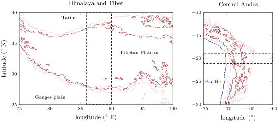
The maps below show the two belts with the same contours, and the swaths along which this chapter cuts them.
14.1.1 The units and the thrusts
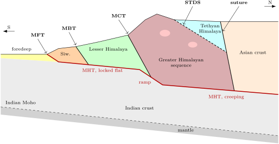
From the Ganges plain northwards, a traverse of the Himalaya crosses a pile of thrust sheets cut from India’s northern margin, separated by faults that run the length of the range.
- The Indo-Gangetic foredeep is the Himalayan foreland basin; it traps part of the debris eroded from the range.
- The sub-Himalaya, the Siwalik Hills, is made of the molasse of that basin, claystones to conglomerates of late Miocene to Pleistocene age, 3500 to thick, laid down between 14 and , then scraped off at the range front and folded above a décollement: a thin-skinned fold–thrust belt. Its southern edge is the Main Frontal Thrust (MFT).
- The Lesser Himalaya, rocks of medium metamorphic grade, lies between the Main Boundary Thrust (MBT) below and the Main Central Thrust (MCT) above.
- The Greater Himalayan sequence (the High Himalaya) above the MCT is made of high-grade metamorphic rocks, partly molten: the migmatites and leucogranites of Chapter 12, melted about 30 million years after the collision.
- The Tethyan Himalayan sequence, unmetamorphosed or weakly metamorphosed sediments of India’s old passive margin, rests on the Greater Himalayan sequence along the South Tibetan Detachment System (STDS), the only normal fault among the great east–west fault zones of the range, more than long.
- North of them comes the suture, and beyond it the Asian crust of southern Tibet.
The faults young southwards. The deformation front moved south as one thrust after another took over, from the Kangmar thrust to the MCT, then the MBT, and now the MFT, which in central Nepal is the only active structure of the sub-Himalaya. It is the same outward migration as in the Alps of Chapter 13, written here in rocks that are still moving. The STDS adds a surprise: a normal fault, extension, inside a range that is being shortened. It shows that compression and extension can work at the same time in one orogen, at different levels, and it helped bring the hot rocks of the Greater Himalayan sequence up from the root of the range.
14.1.2 One fault beneath the range
The thrusts at the surface root into a single gently dipping fault, the Main Himalayan Thrust (MHT), along which the Indian plate is pushed under the range. It reaches the surface at the MFT, runs as a flat beneath the Lesser Himalaya, steepens into a ramp at the front of the High Himalaya, and continues north beneath southern Tibet. Over the Holocene the folding of river terraces across the Siwaliks records a year of shortening on the MFT, the same as the geodetic rate across the whole range. The MHT is locked from the surface to about down dip, at 15 to depth; further north it creeps. The locked part stores the convergence as elastic strain and gives it back in great earthquakes, such as the Assam earthquake of 1950, of moment magnitude about 8.5.
How did the Greater Himalayan sequence, partly molten at depth, come to stand between a thrust below and a normal fault above? One hypothesis, channel flow, has the hot, weak middle crust flowing out southwards between the two shear zones, drawn up towards the surface where erosion is fastest. It is a hypothesis: the share of channel flow, collapse and delamination in the building of the Himalaya and Tibet is still contested.
The range does not float freely. Gravity profiles across Nepal show the Bouguer anomaly falling from about to from the Ganges plain to Tibet. Far from the range, local Airy isostasy holds; near it, the foreland is overcompensated and the high range undercompensated: the Indian plate is bent down like a beam under the load of the mountains and holds them up in part by its own stiffness, a regional support whose study belongs to the Year 3 volume.
In the field — Measuring a mountain belt that moves
A geodesy team in the Himalaya sets up permanent GPS stations: an antenna bolted to bedrock or to a concrete pillar, a receiver, a solar panel, a battery. Each station records its position every day. One day’s position scatters by millimetres, and the noise is not purely random: it wanders over weeks and seasons. The team therefore models the noise, white plus coloured, before fitting a straight line to years of daily positions; the slope is the station’s secular velocity, with an honest uncertainty. Across Nepal, about thirty stations watched for some twenty years show velocities that fall from India’s to southern Tibet’s over a belt about a hundred kilometres wide, above the place where the MHT passes from locked to creeping.
14.2 Tibet, the high plateau
Definition 14.2 (Orogenic plateau)
An orogenic plateau is a region of an orogen, hundreds of kilometres across, where the surface stands high and nearly flat on average, its relief small compared with its height above the surrounding lowlands.
Definition 14.3 (Crustal thickening)
Crustal thickening is the increase of the thickness of the crust of a region, by shortening of the crust itself, by addition of magma from below, or by other crust thrust or flowing beneath it.
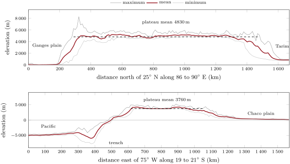
The profiles below cut both plateaus. Along the swath E the mean elevation rises from about on the Ganges plain to about in less than , then stays above for , from N to N, with a mean of . Under it the crust is 70 to thick, twice the 35 to of the Indian crust south of the Ganges plain.
How thick must the crust be under a plateau of given height? Airy’s answer, from the Year 1 volume, gives it in one line.
Proposition 14.4 (Crustal thickness from mean elevation)
Let a crust of density be thick where its surface is at sea level, over a mantle of density . If a plateau of mean elevation is compensated in Airy’s way, its crust is
Conversely, a thickening raises the surface by .
Proof. Airy isostasy gives the root beneath the normal base of the crust; the crust spans the height above sea level, the normal thickness and the root . Adding, . Solving for gives the converse. ∎
With the densities of the Year 1 volume, and , the factor is 5.5: every kilometre of plateau needs of extra crust, of it as root, and every of thickening buys only of height. For Tibet, with and , , short of the 70 to measured. Airy with these round densities underestimates the root; a denser crust, hence a smaller density contrast at the Moho, needs a deeper root for the same height. And near the range, as seen above, part of the load is carried by the bent plate rather than by a local root.
14.2.1 The weight of a plateau
A plateau weighs on its surroundings. At every depth down to the base of its root, a column under the plateau is under a higher pressure than a column under the lowlands next to it; only at the compensation depth are the two equal. The high column pushes outwards.
Proposition 14.5 (Excess potential energy of a plateau)
Under the hypotheses of Proposition 14.4, with gravity , the integral of the excess lithostatic pressure of the plateau column over the normal column, from the top of the plateau to the compensation depth at the base of its root , is
It is the excess gravitational potential energy of the plateau column per unit area, and the force per unit length of the plateau’s edge with which the plateau pushes on its surroundings.
Proof. Measure the depth downwards from sea level. In the plateau column the pressure is from to . In the normal column it is zero above sea level, in the crust, and below. The difference rises from 0 at to at sea level; it keeps this value through the normal crust, where both columns are crust; below it decreases linearly, by per metre, and reaches zero at since . The integral is the area of this trapezium: . The work done by the pressures when the two columns exchange matter sideways is this integral, which is why it measures both the energy and the push. ∎
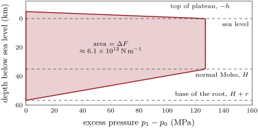
For Tibet, and . Spread over a lithosphere thick, that is a mean excess stress of about , of the order of the stresses that break rocks. A plateau so heavy can no longer simply rise: it tends to spread.
Definition 14.6 (Gravitational collapse)
The gravitational collapse of an orogen is the spreading of its thickened crust under its own weight, by extension of the high regions and outward flow or thrusting at the edges, driven by the excess potential energy of the thickened columns.
Tibet is being stretched while India still pushes it. Across southern Tibet, north–south rifts cut the plateau and accommodate east–west extension: about a year in all between and E, a year on the Yadong–Gulu rift alone; north of Nepal the GPS stations show the southern plateau stretching by about a year. Earthquakes tell the same story: thrust faulting and crustal thickening dominate the lower ground around the plateau, strike-slip and normal faulting its interior. Why it extends is debated. In the eastern plateau the extension has been read as gravitational collapse driven by the weight of the plateau; in the south, others tie it to the curved shape of the Himalayan arc, along which the thrusts diverge, or to India sliding beneath.
14.2.2 Escaping sideways
Definition 14.7 (Lateral extrusion)
Lateral extrusion (escape tectonics) is the expulsion of blocks of crust or lithosphere sideways from a collision zone, along large strike-slip faults, roughly perpendicular to the direction of convergence, towards a free boundary.
East of Tibet, Asia is not shortened only; it is pushed aside. Long left-lateral strike-slip faults, the Red River and the Altyn Tagh faults among them, are read as having guided the eastward and south-eastward escape of large blocks, first the Sunda block of South-East Asia, then Tibet and South China, while rifts and young ocean basins opened at their far ends. Experiments in which a rigid die was pushed into a layer of plasticine produced such faults; models that treated Asia as a continuous viscous sheet produced broad thickening instead, with no great faults. GPS supports the motion of blocks: relative to stable Siberia, the Tarim basin moves roughly northwards at about a year and South China towards the east-south-east at about a year. How much of India’s advance has been absorbed by thickening and how much by extrusion is still argued.
14.3 The Andes
The Nazca plate goes down beneath South America at about a year near S, towards the east-north-east, by the NNR-MORVEL56 angular velocities. No continent has arrived, yet the Central Andes carry the second highest plateau on Earth.
From west to east, between about and S, they comprise five zones: the forearc; the Western Cordillera, the volcanic arc; the high plateau, the Altiplano in the north and the Puna in the south; the Eastern Cordillera; and the thin-skinned fold–thrust belt of the Subandean zone, which passes into the Chaco plain. The profile above crosses them at S: from the trench, whose deepest node lies below sea level at W, the surface climbs more than in about to the edge of the plateau at W; the plateau stays above for with a mean of . The mean height is in the Altiplano and in the Puna. North of S the Moho is generally deeper than ; under the central Altiplano the crust is 59 to thick.
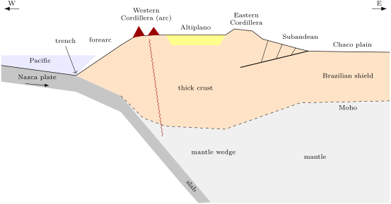
14.3.1 How the crust got thick
Where did the extra crust of the Altiplano come from? The first candidate is shortening: squeeze a strip of crust and it thickens, keeping its cross-sectional area.
Proposition 14.8 (Thickening by shortening)
Let a crust of uniform thickness be shortened, with no gain or loss of rock, into a crust of thickness over a width , the section staying parallel to the shortening. Its original width was , and the shortening is
Proof. The crust’s cross-sectional area is conserved, as in the area balance of Proposition 13.11: . Hence and . ∎
At S the plateau is about wide; if its crust, about thick, was once , the shortening needed is . Balanced sections near 16– S find about of shortening in the Altiplano and more than in the Subandean zone since the Oligocene. The crustal volumes computed from shortening fall about short of those computed from the depth of the Moho. Part of the difference may be wrong assumptions, about the initial thickness or the nature of the seismic Moho; part may be crust added in other ways. One compilation near S credits tectonic shortening with at least of the root, the hydration of the forearc mantle wedge with up to , and magmatic addition and tectonic erosion with only about . Rock may also move inside the belt: differences of crustal thickness create differences of potential energy, as in Tibet, and these can drive the hot lower crust to flow from thick to thin.
14.3.2 Flat slabs and lost roots
The angle of the slab is not fixed, and it matters at the surface.
Definition 14.9 (Flat-slab subduction)
Flat-slab subduction is subduction in which the slab, after its first descent, runs nearly horizontally beneath the overriding plate for hundreds of kilometres before sinking again.
Along the Andes, two segments of the Nazca slab are flat today, the Peruvian segment, flat since about , and the Pampean segment, since about . Above them there are no active volcanoes. When the Pampean slab flattened, the arc moved inland and erupted less lava; above the flat segments it has fallen silent. The arc–trench gap of the Year 1 volume explains the inland move: the gentler the slab beneath the arc, the farther from the trench it reaches the depth at which the wedge melts; and a slab that stays flat above that depth leaves no hot mantle wedge to melt at all.
Definition 14.10 (Lithospheric delamination)
Lithospheric delamination is the detachment and sinking into the asthenosphere of the lower part of a thickened lithosphere, its mantle lithosphere and sometimes a dense lower crust, replaced by hot asthenosphere.
Delamination has been proposed beneath the southern Puna, between and S, about 2 to ago, where young mafic lavas erupted; and along the plateau, changes of crustal thickness and elevation have been tied to a mantle lithosphere already removed beneath the southern Altiplano and not yet completely beneath the central Altiplano. Losing a dense mantle lid makes the remaining column lighter: the surface rises without any more shortening. The Puna stands about higher than the Altiplano on a crust about thinner, a contrast that needs either a lighter Puna crust or a lighter mantle beneath it.
14.4 Two belts compared
The two plateaus look alike from far away and differ in almost everything else, as the table below gathers.
| Himalaya and Tibet | Central Andes | |
|---|---|---|
| engine | continent against continent after the ocean closed | ocean plate sinking beneath a continent |
| axis | suture with ophiolites | volcanic arc above the slab |
| magmatism | crustal melts: leucogranites | arc andesites; mafic lavas where the lithosphere was lost |
| convergence | about a year, half taken in the range | about a year, mostly consumed by subduction |
| great earthquakes | on the MHT, Assam 1950, | on the subduction interface, Chile 1960, 9.5 |
| plateau | mean over ; crust 70– | mean over ; crust about |
| plateau tectonics | east–west extension, extrusion | shortening on the flanks; delamination proposed |
| foreland | Indo-Gangetic foredeep and Siwalik molasse | Subandean belt and Chaco plain |
The deepest difference is in what goes down. In the Andes the ocean plate keeps sinking, and most of the convergence, about a year, is consumed at the trench; shortening the upper plate by over some 30 million years would take only about a year of it. In the Himalaya nothing light can sink for long, so the convergence is spent on stacking, thickening and pushing Asia aside. Both belts grow plateaus because a thick crust is a high crust; both plateaus stop rising when their own weight balances the push at their edges, and then they spread.
14.5 How high can a mountain be?
The highest summit, Everest, stands above sea level by the joint survey announced in 2020. Why not twenty kilometres? A rough bound comes from the strength of rock.
Proposition 14.11 (A height limit from rock strength)
A column of rock of density standing a height above its surroundings, with no lateral support above their level, carries at its foot a vertical stress and a horizontal stress of zero on its free sides, hence a differential stress . If the rock fails at the differential stress , the column stands only if .
Proof. At the foot of the column the vertical stress is the weight of the rock above per unit area, . The sides are free, so the horizontal stress there is zero. The differential stress is the difference of the greatest and least principal stresses, here . Failure is avoided only if it stays below . ∎
A real mountain has sloping flanks that hold its core in, so the stress beneath it is smaller; as an order of magnitude take half, . For Everest, . Byerlee’s law of the Year 1 volume puts the frictional strength of rock on a fault under a normal stress of at : the same order. A mountain three times higher would load its base far beyond what rock can bear; it would fail and spread. On Earth, summits of eight to nine kilometres are close to the limit, and a plateau, which spreads long before its summits fail, levels off at five.
Exercises
Data for the exercises: ; densities of crust and mantle and unless stated; normal crust .
Exercise 14.1 ★
A plateau stands at a mean elevation of . Using Proposition 14.4, compute (a) its Airy root, (b) its crustal thickness. (c) By how much would more of crust raise it?
Solution
Solution of Exercise 14.1.
(a) . (b) , or . (c) .
Exercise 14.2 ★
A traverse of the Himalaya of Nepal runs from the Ganges plain to the Tibetan Plateau. (a) List, in order, the units it crosses and the faults that separate them. (b) Which fault is a normal fault? (c) How does the metamorphic grade change northwards up to the Greater Himalayan sequence, and then above it?
Solution
Solution of Exercise 14.2.
(a) Indo-Gangetic foredeep; Main Frontal Thrust; sub-Himalaya (Siwaliks); Main Boundary Thrust; Lesser Himalaya; Main Central Thrust; Greater Himalayan sequence; South Tibetan Detachment System; Tethyan Himalayan sequence; then the Indus–Tsangpo suture and the Asian crust. (b) The South Tibetan Detachment System. (c) The grade rises northwards: unmetamorphosed molasse, medium-grade Lesser Himalaya, high-grade and partly molten Greater Himalayan sequence; above the STDS it drops abruptly to unmetamorphosed or weakly metamorphosed Tethyan sediments, since the normal fault has removed the rocks in between.
Exercise 14.3 ★
In central Nepal a river terrace abandoned ago has been shortened by across the folds of the Main Frontal Thrust. (a) Compute the mean shortening rate in millimetres a year. (b) Compare it with the GPS convergence across the range, a year. (c) What does the agreement say about the faults north of the MFT?
Solution
Solution of Exercise 14.3.
(a) a year, about a year. (b) It is more than the a year of GPS, but of the same size: one rate is averaged over nine thousand years, the other over twenty. (c) Nearly all the shortening across the range is taken up at the front: the MBT, the MCT and the other faults north of the MFT are, at this longitude, practically inactive; they all root in the same MHT, which comes up at the MFT.
Exercise 14.4 ★
Sort each observation into collision orogen, Andean-type orogen or both: (a) a suture lined with ophiolites; (b) a line of active andesitic volcanoes; (c) leucogranites melted from the crust; (d) a deep oceanic trench along the front; (e) a foreland basin with molasse; (f) great earthquakes on a gently dipping fault beneath the range.
Solution
Solution of Exercise 14.4.
(a) Collision: the suture marks the vanished ocean. (b) Andean-type: an arc needs a slab going down. (c) Collision, typically: crustal melts of a thickened, heated crust (they also occur in thickened Andean crust, but the arc magmas dominate there). (d) Andean-type. (e) Both: the Siwaliks and the Subandean foreland. (f) Both: the MHT in the Himalaya, the subduction interface in the Andes.
Exercise 14.5 ★★
India moves at a year relative to Eurasia across the Himalaya; across Nepal the range itself absorbs a year in the east and a year in the west. (a) What fraction of the convergence does the range take in each case? (b) Where does the rest go? (c) Over , how much shortening does the remainder represent?
Solution
Solution of Exercise 14.5.
(a) in the east, in the west: about half. (b) Into the thickening and the faults of Tibet and the rest of Asia, and into the eastward extrusion of blocks along the great strike-slip faults. (c) a year, or in ; a year, or .
Exercise 14.6 ★★
(a) Using Proposition 14.5, compute the excess potential energy of the Altiplano, mean elevation . (b) Compare it with Tibet’s at . (c) Show that for a thin plateau, , grows in proportion to , and for a thick one faster: what does that imply for the growth of a plateau?
Solution
Solution of Exercise 14.6.
(a) ; . (b) Tibet: ; the Altiplano has of it. (c) With , : for the term dominates and is proportional to ; for a high plateau the term in grows faster. Each further kilometre of height costs more and more push at the edges, until the forces available can no longer raise the plateau; it then spreads instead of rising.
Exercise 14.7 ★★
(a) Compute beneath Everest, high, with . (b) By Byerlee’s law, below of normal stress and above; compute for and . (c) What height would a strength of allow, by the same order-of-magnitude rule?
Solution
Solution of Exercise 14.7.
(a) . (b) At : ; at : , the two branches agree. (c) : an order of magnitude, of the order of the highest summits, not far above them.
Exercise 14.8 ★★
The rifts of southern Tibet take up a year of east–west extension between and E. (a) How wide is that stretch at N, with per degree on a meridian? (b) Compute the mean extensional strain rate, per year and per second, with its range. (c) Compare with the a year found from GPS north of Nepal.
Solution
Solution of Exercise 14.8.
(a) . (b) a year (between and for 7 and a year), that is . (c) The two ranges overlap: spans 7.7 to . The southern plateau north of Nepal stretches as fast as, or a little faster than, the belt as a whole.
Exercise 14.9 ★★
The locked Main Himalayan Thrust beneath Nepal accumulates a moment deficit of a year; the earthquakes of the last 500 years released only a year. (a) What fraction of the deficit did they release? (b) With , compute the moment of an 8.5 earthquake. (c) How often would such earthquakes be needed to balance the deficit?
Solution
Solution of Exercise 14.9.
(a) . (b) . (c) : one such earthquake about every 110 years beneath Nepal, far more than history records; either much larger earthquakes are due, or part of the deficit is released otherwise.
Exercise 14.10 ★★★
The Puna stands higher than the Altiplano (4.4 against ) on a crust thinner. Take the Altiplano crust thick and of density , and a mantle of under both. (a) Write the equality of the masses of the two columns above a common compensation depth. (b) Find the density the Puna crust must have if the crust alone compensates the difference. (c) Compare with the 150 to quoted, and say what else could explain the contrast.
Solution
Solution of Exercise 14.10.
(a) Take the compensation depth at the base of the Altiplano crust, below sea level. The Puna crust reaches , so the Puna column holds of mantle above that depth: . (b) . (c) The difference, , lies at the lower end of the 150 to quoted: crust alone would need an unusually light Puna crust. A lighter column beneath it does it more easily: a mantle lithosphere removed by delamination, replaced by hot, light asthenosphere.
Exercise 14.11 ★★★
The volcanic front stands where the top of the slab is deep. (a) For a slab dipping uniformly at , compute the arc–trench gap with the formula of the Year 1 volume. (b) The slab now dips at down to , then at only : compute the new gap and the inland shift of the arc. (c) What happens to the arc if the slab flattens at depth and stays there for ?
Solution
Solution of Exercise 14.11.
(a) . (b) : the arc moves inland. (c) The slab never reaches beneath the plate for those , and no hot mantle wedge lies above it: no magma is made and the arc dies until the slab sinks again, further east.
Exercise 14.12 ★★★
Erosion removes about of rock per kilometre of the Himalaya per million years. India brings in crust thick at a year. (a) How much crust per kilometre of range per million years enters the belt? (b) What fraction does erosion remove? (c) Where can the rest be?
Solution
Solution of Exercise 14.12.
(a) a year is per million years: per kilometre of range per million years. (b) . (c) In the thickening of the range and of southern Tibet, in crust carried down with India beneath Tibet, and in the material that the MHT passes northwards.
Problem 14.1
Weekend problem — two plateaus
The swath profiles of this chapter give the mean elevation of the nodes across Tibet ( E) and across the Central Andes ( S). Sampled every of latitude and every degree of longitude, rounded to , they read as follows. Unless stated, , , and the normal crust is thick.
| latitude ( N) | 26.5 | 28.0 | 29.5 | 31.0 | 32.5 | 34.0 | 35.5 | 37.0 | 38.5 |
|---|---|---|---|---|---|---|---|---|---|
| mean elevation () | 70 | 5000 | 5030 | 4830 | 5020 | 5150 | 5050 | 4470 | 2210 |
| longitude () | ||||||||
|---|---|---|---|---|---|---|---|---|
| mean elevation () | 970 | 4150 | 3720 | 3740 | 4010 | 3030 | 1170 |
Part I — Reading the profiles.
- Taking as plateau the samples above , compute the mean elevation of Tibet , rounded to .
- Do the same for the Altiplano, , and compare with the mean height of quoted for the Altiplano and for the Puna.
- How wide is each plateau, at least, according to the samples ( per degree of latitude; per degree of longitude at S)?
- Compute the mean slope of the Himalayan front between and N, as a percentage.
- Why is the Andean profile so much more asymmetric than the Tibetan one?
Part II — Airy thicknesses.
- Compute the Airy root and the crustal thickness of Tibet from .
- Do the same for the Altiplano, .
- Compare with the seismic thicknesses, 70 to under Tibet and 59 to under the central Altiplano. Which estimate is further off?
- What crustal density would make Airy’s thickness for Tibet equal to ?
- What density would give for the Altiplano?
- Name two reasons, other than the crustal density, why a local Airy calculation can miss the observed root.
- The crust is thick under India and under Tibet. With a density contrast at the Moho of , estimate with the Bouguer slab, , the Bouguer anomaly of Tibet’s root relative to India, being the extra thickness below sea level (). Compare with the observed difference of .
Part III — Shortening the Altiplano. At S the plateau is wide and its crust about thick.
- Using Proposition 14.8, compute the restored width and the shortening needed if the crust was thick before.
- Balanced sections give about of shortening in the Altiplano and in the Subandean zone. What fraction of the needed shortening is missing?
- If shortening made only of the extra crust, how much shortening is needed?
- The Subandean belt is thin-skinned. Why must its shortening still thicken the crust somewhere?
- Suppose the of Part III accumulated over . Compute the mean rate, and the fraction of today’s Nazca–South America convergence, a year, that it represents.
- Where does the rest of the convergence go?
Part IV — The weight of Tibet.
- Using Proposition 14.5 with , compute Tibet’s excess potential energy per unit area.
- Compute it for the Altiplano with , and the ratio of the two.
- Spread Tibet’s over a lithosphere thick: what mean stress does it represent?
- The extension of southern Tibet, a year across , is how much strain a year?
- Why can Tibet extend east–west while India still pushes it north?
- To sum up: give the crustal thickness of Tibet computed from its mean elevation, rounded to the kilometre, and the fraction of the seismic it accounts for.
Solution
Solution of Problem 14.1.
1. Seven samples from to N: , . 2. Five samples from to : , , the value quoted for the Altiplano; the Puna, further south, is higher. 3. Tibet: at least ; the Altiplano: at least . 4. : . 5. The Andean profile starts on the ocean floor and in the trench, kilometres below sea level, west of the plateau; the Tibetan one starts on a continental plain near sea level, and ends on the high Tarim basin. 6. ; . 7. ; . 8. Tibet: against 70 to , short of the mid value (); the Altiplano: against 59 to , short of (). Tibet is further off. 9. : , . 10. : , . 11. Part of the load is carried by the bending of the plate, not by a local root; the normal crust may not have been thick; the mantle beneath may be lighter or denser than assumed; the seismic Moho may not be the base of the crust in the density sense. 12. The base of Tibet’s crust lies at , India’s at : . , that is relative to India, close to the observed . 13. ; . 14. , the shortfall found in the Central Andes. 15. , less than the of the balanced sections, which would then be more than enough. 16. The cover shortened above the décollement must be matched by shortening of the basement beneath it, further west, since both must lose the same length across the belt; the basement shortening thickens the crust under the Eastern Cordillera and the plateau. 17. a year, of the convergence. 18. It is consumed by subduction: the Nazca plate sinks beneath the continent. 19. ; . 20. ; the ratio is 0.70. 21. , about . 22. a year. 23. The push of India acts north–south and is balanced, in the high plateau, by the plateau’s own weight: north–south the plateau can no longer thicken, so the vertical stress, the weight, is the greatest; the least stress is east–west, towards the free edges of Asia, and the plateau extends that way, on north–south rifts. 24. , about of the measured.