书籍暂未推出简体中文版——当前显示英文版。
University Earth and Space Sciences — Year 2 · 本科二年级
15Ancient Massifs and the Wilson Cycle
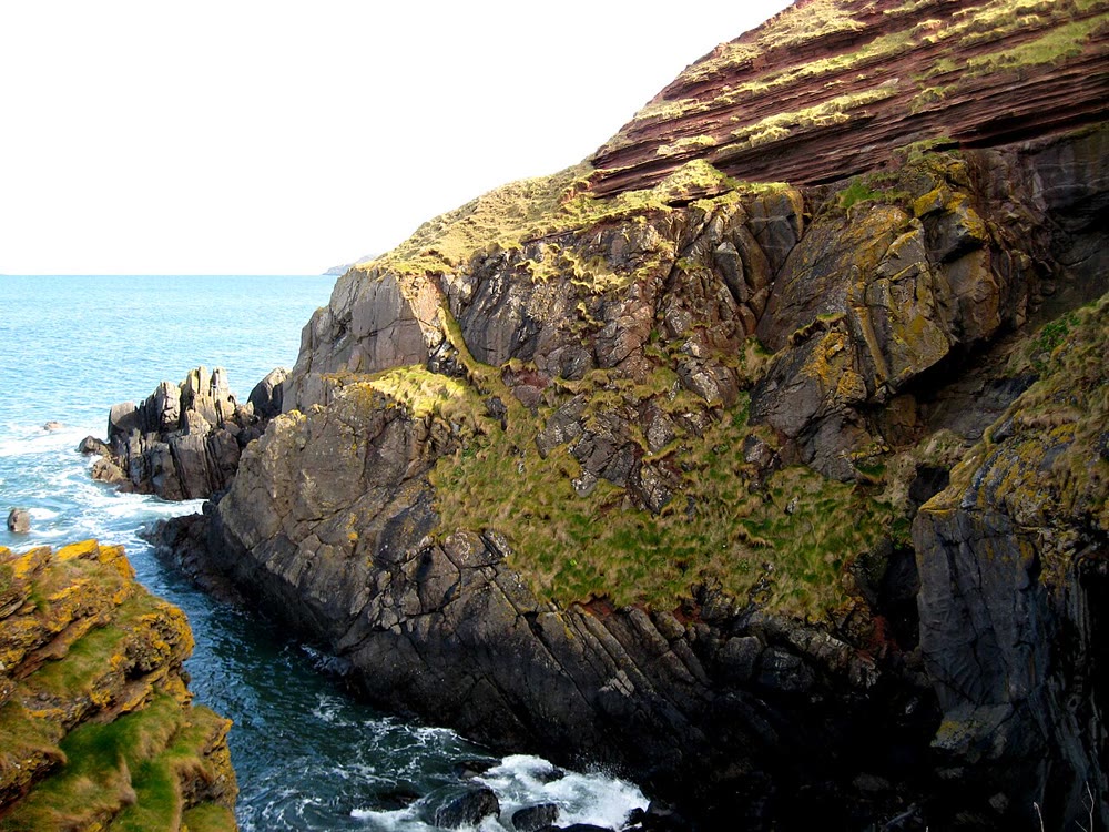
On the coast of south-east Scotland, at Siccar Point, grey beds of sandstone stand on end under a cap of red sandstone that dips gently towards the sea. The grey beds were laid down in an ocean early in the Silurian, then folded and cleaved when that ocean closed; they were worn down to an uneven surface; in the Late Devonian red gravels buried them, and a second, gentler mountain building tilted the red beds in turn. One cliff records an ocean that has vanished, a mountain belt that has gone, and the next one. This chapter reads such records, gathers them into a cycle that ocean basins follow, and steps back to the longest rhythm of all, the assembly and break-up of supercontinents.
You already know
From the school volumes: Pangaea and its break-up, supercontinents; unconformities; the denudation rate, isostatic rebound, and the exponential decay of a mountain range worn down by its rivers. From the Year 1 volume: continental rifts, passive margins and mid-ocean ridges, the full and half spreading rates; subduction and active margins. From Chapter 12 to Chapter 14: migmatites and granites; orogen, ophiolite, suture, nappe, flysch and molasse, foreland basin; collision and Andean-type orogens; crustal thickening, Airy thickness and gravitational collapse.
15.1 Belts worn to their roots
Western Europe and eastern North America are crossed by mountain belts far older than the Alps. Their summits have gone, but their rocks remain. Three of them matter here.
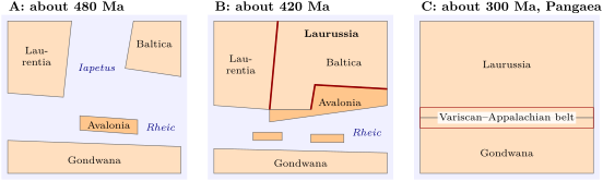
The Caledonian belt runs from Norway through Scotland and Ireland to Newfoundland and the northern Appalachians, and on through East Greenland and Svalbard. It is the record of an ocean, the Iapetus, that lay in the early Palaeozoic between Laurentia, the ancestor of North America and Greenland, to the north-west, and Baltica and Avalonia to the south-east and east. Its margins had rifted about 600 million years ago; its closure, from the Cambrian to the Devonian, produced a whole series of collisions, so that the Caledonian orogeny spans some 200 million years. The term names a place and an ocean, not an age.
The Variscan belt, called Hercynian in older texts, crosses Europe from south-west England and Belgium through France and Iberia into central Europe; the Appalachian belt of eastern North America is its western twin. Together they record the closure of the oceans between the southern continent, Gondwana, and the northern one, which had just been welded by the Caledonian collisions. Their last collision, in the Late Carboniferous and Permian, left a fold belt running east–west through southern Europe and north-east–south-west between eastern North America and north-west Africa, and with it the supercontinent Pangaea.
How does one recognise a mountain belt that has been eroded for three hundred million years? Not by its relief, which has gone. One looks for its parts, each of which the previous chapters have met:
- sutures lined with ophiolites, slices of the ocean floor that closed;
- belts of metamorphic rocks, often of high grade, the roots of the thickened crust, now at the surface because the kilometres above them were eroded;
- granites and migmatites, the products of the crustal melting that thickening and heating bring;
- sediments of the closing ocean and of the belt: flysch shed into deep basins during the convergence, molasse shed into foreland and intramontane basins;
- angular unconformities, where younger beds rest on beds that were folded and eroded before them, dating the deformation between the two.
Definition 15.1 (Peneplain)
A peneplain is a land surface of low relief, near the base level of erosion, cut across rocks of different hardness and structure by long erosion of a former relief.
The Variscan belt is a hot orogen. In the Alps of Chapter 13, the rocks followed metamorphic gradients of about per kilometre; in the Variscan belt, about per kilometre. Its crust melted widely: in the French Massif Central and Armorican Massif, migmatites formed between about 330 and 325 million years ago, and granites intruded them. That melting is the main difference from the Western Alps. As the collision ended, the thickened crust thinned by extension, metamorphic rocks were brought up along detachments, and intramontane basins opened; then erosion levelled the chain into a Permian and Triassic peneplain on which the sediments of the next cycle were laid.
| phase | age | what collided |
|---|---|---|
| Penobscotian | 490–485 Ma | an island arc thrust onto the Avalonian margin |
| Grampian, Taconian | 480–455 Ma | island arcs against Laurentia (Scotland; the northern Appalachians) |
| Shelveian | early Late Ordovician | Avalonia against Baltica; the Tornquist Sea closes |
| Scandian | 425–400 Ma | Baltica against Laurentia; the great nappes of Scandinavia |
| Acadian | Early Devonian | terranes from Gondwana against the new continent; Iapetus closed |
The Caledonian table above shows the other mark of old belts: they are composite. Before the two continents met, arcs and smaller blocks came in one by one and were welded on.
Definition 15.2 (Terrane; microcontinent)
A terrane is a fault-bounded block of crust whose geological history differs from that of its neighbours, brought to its present position by plate motion; it may be an island arc, an oceanic plateau, a slice of ocean floor or a fragment of continent. A microcontinent is a block of continental crust, smaller than a continent, separated from the continents by oceanic crust.
Avalonia was such a block: a strip of crust that left the margin of Gondwana, opened the Rheic Ocean behind it in the Ordovician, crossed the Iapetus and docked against Baltica and then Laurentia. Armorica and Saxothuringia, now in France and Germany, followed it in turn; their sutures, marked by ophiolites, divide the Variscan belt into zones from a northern foreland in the old northern continent to a southern foreland in Gondwana.
15.2 The Wilson cycle
In 1966 J. Tuzo Wilson asked whether the Atlantic had closed and then opened again. Fossils of the early and middle Palaeozoic told him that a wide ocean had then separated the faunas of North America from those of Western Europe, an ocean that no longer existed from the late Palaeozoic to the middle of the Mesozoic. The modern Atlantic had opened nearly where that older ocean, the Iapetus, had closed.
Definition 15.3 (Wilson cycle)
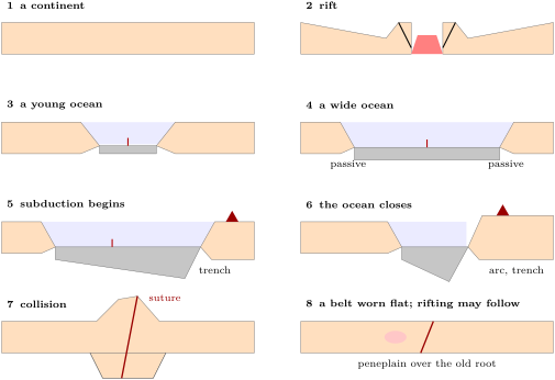
The Wilson cycle is the succession of stages through which an ocean basin opens and closes again between continental margins: continental rifting, break-up and sea-floor spreading, a widening ocean with passive margins, the start of subduction, the narrowing and closure of the ocean, continental collision, and the collapse and erosion of the belt, after which the welded continent may rift again along the same zone.
The figure below follows the stages. They are those of the previous chapters put in order: the rifts and passive margins of the Year 1 volume, the active margins and their arcs, the Alpine and Himalayan collisions, the gravitational collapse of Tibet, the slow wearing-down of the old belts.
15.2.1 How wide, how long?
An ocean grows by sea-floor spreading at its ridge and shrinks by subduction at its trenches. Simple bookkeeping gives its width.
Proposition 15.4 (Width of an ocean through a cycle)
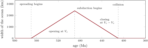
Let an ocean open at time and widen at the full spreading rate of its ridge, until a subduction zone starts at one margin at time and consumes ocean floor at the rate relative to that margin, with , the ridge still spreading. Its width is
greatest at , and the ocean closes a time after subduction begins. With symmetric spreading, the ridge moves towards the trench at .
Proof. Hold the margin with the trench fixed. Before the two margins separate at the full spreading rate , so the width grows at from zero. After the plate between trench and ridge moves towards the trench at ; the ridge adds to the distance between that plate and the far plate, so the far margin moves towards the trench at , the rate at which the width decreases. The width reaches zero after . With symmetric spreading the ridge moves at the mean of the velocities of the plates on either side, . ∎
The figure below plays this bookkeeping for a model ocean of the Iapetus type: spreading from at a year, subduction from consuming a year. The rates are assumptions, round values of the size measured today in the oceans; the real Iapetus was neither so simple nor so well known. The model ocean reaches and closes at , within the time span of the Scandian collision.
15.2.2 Opening where it closed
Wilson’s idea rests on a mechanical one: an old belt is a weak zone, and a continent that is pulled apart tends to break along its weak zones rather than through its strong, stable interior.
Definition 15.5 (Structural reactivation)
The structural reactivation of a pre-existing structure (a fault, a shear zone, a suture, a lithological contact) is the renewed concentration of deformation along it, under a later stress field that may differ from the one that formed it.
The North Atlantic is the test case, and it passes only in part. In the Central Atlantic the young ocean follows the Appalachians closely. Between Scandinavia and Greenland the break-up broadly follows the Caledonian belt. Further south it does not: the Iapetus suture still runs through northern England and central Ireland, and the Atlantic opened west of it, leaving pieces of Laurentia’s old crust on Europe’s north-western margin, around Rockall and Hatton. Further north-west, the Labrador Sea and Baffin Bay cut straight across older cratons and belts. Old structures guide later rifts, but not always: a weakness that has cooled for more than 30 to 50 million years may have become strong, and a new rift may follow the deeper fabric of the mantle rather than the crustal suture. The Wilson cycle is a guide, not a law.
Not every cycle opens a wide ocean. Many orogens close embryonic oceans, rifts that had barely started spreading, less than about wide: the Alps, the Pyrenees, most of the Variscan belt of western Europe. Others close wide, mature oceans, as the Scandinavian Caledonides did. The difference shows at the end. A belt that closed a wide ocean carried a long-lived arc, which drained the mantle beneath of its fusible part; its collapse was poor in magma, as in the Caledonides. A belt that closed a narrow basin sits on fertile mantle; its collapse can be rich in magma, as in the Variscan belt, where the Moho is now flat and the lower crust layered, read as basalt underplated beneath the crust or as lower crust sheared while hot. Within a few tens of millions of years the heat anomalies of a belt fade; its structures remain.
15.3 Supercontinents
Definition 15.6 (Supercontinent; supercontinent cycle)
A supercontinent is a landmass that gathers most of the Earth’s continental crust into a single block. The supercontinent cycle is the episodic assembly of the continents into a supercontinent and its later break-up, repeated through Earth’s history.
Pangaea, which Wegener reconstructed and the school volumes described, existed from about 325 to 200 million years ago. Earlier supercontinents have been proposed: Pannotia about 620 to 580 million years ago, whose existence is debated; Rodinia about 950 to 800 million years ago; Nuna, also called Columbia, about 1.6 to 1.4 billion years ago; and, more doubtful, Kenorland about 2.7 to 2.5 billion years ago and Ur about 3.0 billion years ago. They seem to have assembled and broken up at intervals of roughly half a billion years since perhaps the late Archaean. The cycle has been linked to the ages of mountain building, to peaks in the ages of granites and of the zircon grains they contain, to the growth of the crust, to large igneous provinces, to sea level and to climate: the assembly of a supercontinent tends to coincide with cooling.
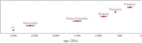
Is the cycle truly periodic? The midpoints of the intervals in the chart are separated by 400, 1100, 625, 275 and 337.5 million years: on average about 550, but scattered by a factor of four. “Roughly half a billion years” is a tendency, not a clock, and the earlier supercontinents rest on sparse evidence.
15.4 From mountains to plains
What turns a belt like the Himalaya into the low hills of Brittany? The high-school volume built a model: rivers wear a range down at a rate proportional to its mean elevation, , and every metre removed from the top is partly given back by isostatic rebound, so that only the fraction of it is lost as height. The mean elevation then decays as
with the time constant . In large mid-latitude basins, the denudation rate is proportional to the mean relief, and without uplift the relief would fall to a tenth of its value in about 11 million years: per million years. With the densities 2700 and , and : a range high still stands high some 30 million years later, and sinks below after about 60 million years.
The same rebound explains why old belts expose their roots. To bring a crust thickened from to back to sea level, all the extra thickness must be eroded, while the mean elevation was only : about 5.5 times more rock is removed than the height of the range. Rocks that were 20 or deep in the root come to the surface: the migmatites, granites and high-grade gneisses of the old massifs, such as those of the Massif Central.
The Variscan chain, whose last collisions ended about 290 million years ago, had been levelled into a peneplain during the Permian and Triassic: within the 60 million years or so that the model gives. Collapse can make it faster: the extension of a thickened crust, as in Tibet today, thins it directly, without waiting for the rivers. And at Siccar Point, Late Devonian gravels rest on Silurian beds folded in the Caledonian collisions, on an old land surface that still keeps some relief between the hard and the soft beds.
In the field — Reading an angular unconformity
Geologists who study an angular unconformity such as Siccar Point begin by measuring the attitude of the beds below and above the surface, strike and dip, at many places. They look for the way up of the lower beds, by graded bedding or by the marks on the bases of the beds, since folded beds can be overturned. They examine the surface itself: its relief, the weathering beneath it, the pebbles of the older rocks in the conglomerate above it. Then they date: the youngest fossils below give the age before which the folding cannot have happened, the oldest fossils above the age before which it had happened and the land had been worn down. The gap between the two brackets the orogeny. At Siccar Point the lower beds are early Silurian and the upper ones Late Devonian, and the Caledonian folding, uplift and erosion fit between; the gentle tilt of the upper beds is younger again, Variscan.
Exercises
Data for the exercises: ; densities of crust and mantle and ; normal crust ; ages of the bases of the Silurian, Devonian and Carboniferous 443.1, 419.6 and , of the Triassic .
Exercise 15.1 ★
The margins of the Iapetus rifted about ; the main Caledonian collision, the Scandian, ended about ; the first arc–continent collision with Laurentia began about . (a) How long did the whole cycle of the Iapetus last? (b) How long did the collisions last? (c) Why should “Caledonian” not be used to mean an age?
Solution
Solution of Exercise 15.1.
(a) , from the rifting of the margins to the last collision. (b) . (c) The Caledonian orogeny is a set of phases spread over some 200 million years, and each phase began at different times in different places: the word locates an ocean and its belt, not a moment. An age is given by the stratigraphic scale or in millions of years.
Exercise 15.2 ★
Put these situations in the order of the Wilson cycle and name the stage of each: (a) the Red Sea, a narrow ocean between young rifted margins; (b) the Himalaya; (c) the East African rift; (d) the Atlantic Ocean, wide, with passive margins on both sides; (e) the Pacific margin of South America; (f) the low hills of Brittany on an old granite and gneiss basement.
Solution
Solution of Exercise 15.2.
(c) the East African rift, rifting; (a) the Red Sea, a young ocean; (d) the Atlantic, a wide ocean with passive margins; (e) the Pacific margin of South America, subduction and the closing of an ocean; (b) the Himalaya, collision; (f) Brittany, a belt worn flat, after which rifting may start again.
Exercise 15.3 ★
At Siccar Point early Silurian beds lie under Late Devonian ones. (a) Between which bounds, given by the data above, must the folding, uplift and erosion have taken place? (b) What is the longest time they could have taken? (c) List in order the events the cliff records.
Solution
Solution of Exercise 15.3.
(a) After the deposition of the early Silurian beds, so after , and before the deposition of the Late Devonian beds, so before , the end of the Devonian. (b) Less than ; in fact less, since the lower beds are younger than the base of the Silurian and the upper beds older than its top. (c) Deposition of the grey turbidites in the ocean; folding and cleavage in the Caledonian collisions; uplift and erosion to an uneven land surface; deposition of the red breccias and conglomerates; gentle tilting in the Variscan orogeny; today’s erosion, which cuts the cliff.
Exercise 15.4 ★
Say whether each is a terrane, a microcontinent, both or neither, and why: (a) Avalonia; (b) Laurentia; (c) an island arc accreted to a continent; (d) the Iapetus suture.
Solution
Solution of Exercise 15.4.
(a) Both: a block of continental crust separated from the continents by oceans while it crossed the Iapetus, and, once docked, a fault-bounded block whose history differs from its neighbours’. (b) Neither: a continent, not a block added to one. (c) A terrane, not a microcontinent: its crust is that of an arc, not a fragment of a continent. (d) Neither: it is the boundary between terranes, the trace of the closed ocean.
Exercise 15.5 ★★
Take the midpoints of the intervals of the supercontinents Ur (3000), Kenorland (2600), Nuna (1500), Rodinia (875), Pannotia (600) and Pangaea (262.5), in millions of years ago. (a) Compute the five spacings and their mean. (b) What is the ratio of the largest spacing to the smallest? (c) Drop Kenorland and Ur, which are doubtful: what is the mean spacing of the other four? Is “half a billion years” a period?
Solution
Solution of Exercise 15.5.
(a) , , , , ; mean . (b) . (c) . The mean moves by a quarter when the doubtful points are dropped and the spacings vary fourfold: a rough recurrence, not a period.
Exercise 15.6 ★★
An ocean wide begins to be subducted at one margin at a year, while its ridge spreads at a year. (a) How long does it take to close? (b) How long if spreading stops at once? (c) Which plate’s motion sets the closing rate after the ridge has been subducted?
Solution
Solution of Exercise 15.6.
(a) . (b) . (c) Once the ridge has been subducted, the ocean floor left is part of the far plate, which carries the far continent: the closing rate is the velocity of that plate relative to the trench.
Exercise 15.7 ★★
Suppose that crustal melting starts at about and that the surface is at . (a) At what depth is that temperature reached along a gradient of per kilometre? Of per kilometre? (b) Which belt, the Alps or the Variscan belt, should then expose migmatites and granites of crustal origin? (c) Why does a fixed gradient overstate the depth in the first case?
Solution
Solution of Exercise 15.7.
(a) ; . (b) The Variscan belt: at per kilometre the middle crust melts; at per kilometre the melting temperature lies below the base of even a thickened crust. (c) The low gradient describes rocks carried down fast in a subduction zone, before they could heat up. Rocks that stay deep in a thickened crust warm towards a normal geotherm over millions of years, and can then reach melting at smaller depth.
Exercise 15.8 ★★
The Variscan collisions ended about ; a peneplain had formed by the Permian and Triassic. Use the decay model of the chapter, . (a) How long does a range take to fall from a mean elevation of to ? (b) At what age would that be? (c) What time constant would bring it there by the base of the Triassic? (d) What process can shorten the time?
Solution
Solution of Exercise 15.8.
(a) . (b) , in the Late Triassic. (c) . (d) The extensional collapse of the thickened crust, which thins it and lowers its surface directly; also a higher erosion rate, a wetter climate or softer rocks, or a lower starting elevation.
Exercise 15.9 ★★
(a) Explain why the Iapetus suture in northern England and central Ireland, and Laurentian crust near Rockall, show that the Atlantic did not reopen exactly along the old suture. (b) What would a geologist expect to find in the old basement on either side of the suture in Ireland? (c) The Appalachians had been deformed until the Early Permian; rifting began about 80 million years after the orogeny. Compare with the 30 to 50 million years after which a cooled zone may be too strong to reactivate.
Solution
Solution of Exercise 15.9.
(a) The suture, the trace of the Iapetus, lies on land in Britain and Ireland, east of the Atlantic; crust of Laurentia, from the far side of the Iapetus, lies near Rockall on the European side. The new rift cut west of the old suture: it opened near it, not along it. (b) North of the suture, basement and cover of the Laurentian margin; south of it, those of Avalonia, with different histories and, in the early Palaeozoic, different faunas. (c) Rifting came after 80 million years, more than the 30 to 50 after which a cooled zone may have grown strong; yet the Central Atlantic did follow the Appalachians. The heat of a belt fades; its faults, fabrics and compositions remain and can still guide a rift.
Exercise 15.10 ★★★
An ocean wide has its ridge in the middle, from a trench that consumes the plate on its side at a year; the ridge spreads at a year, symmetrically. (a) How fast does the ridge approach the trench? (b) When does it reach it? (c) How wide is the ocean then? (d) What happens to the volcanic arc when a ridge is subducted?
Solution
Solution of Exercise 15.10.
(a) a year. (b) . (c) The ocean narrows at a year: . (d) Young, hot lithosphere then arrives at the trench, and no old, cold slab dehydrates beneath the arc any more: the arc magmatism changes or stops.
Exercise 15.11 ★★★
A collision thickens a crust from to , compensated in Airy’s way. (a) What is the mean elevation, by Proposition 14.4? (b) How much rock must erosion remove to bring the surface back to sea level with a crust of normal thickness? (c) What was the lithostatic pressure on the rocks that end at the surface? (d) In which metamorphic facies can they have recrystallised?
Solution
Solution of Exercise 15.11.
(a) . (b) All the extra , 5.5 times the height of the range. (c) , about . (d) At about and the temperatures of the root of a thickened crust, several hundred degrees, the amphibolite or the granulite facies: the gneisses and migmatites of the old massifs.
Exercise 15.12 ★★★
After two continents meet, convergence goes on at a year for . The shortening is taken up across a belt that ends wide, in a crust that was thick. (a) Using Proposition 14.8, find the crustal thickness. (b) Find the Airy elevation and root. (c) Using Proposition 14.5, compute the excess potential energy and compare it with Tibet’s, . (d) What should follow?
Solution
Solution of Exercise 15.12.
(a) ; ; . (b) ; . (c) , 1.4 times Tibet’s. (d) Such a belt is heavier than Tibet, which already spreads: gravitational collapse, by extension of its high regions and thrusting at its edges.
Problem 15.1
Weekend problem — Iapetus from birth to death
A model ocean of the Iapetus type opens between two continents, L to the north-west and B to the south-east. Rifting begins at ; sea-floor spreading at . Unless stated, , , and the normal crust is thick. Spreading is symmetric and its rate constant.
Part I — Opening.
- At , ocean floor formed at lies from the ridge axis. Compute the half spreading rate in millimetres a year.
- Deduce the full spreading rate. To which class of ridge does it belong, among slow, fast and ultraslow ridges?
- How wide was the ocean at ?
- How wide was it at ?
- What did the model assume to get these widths?
- How old is the oldest ocean floor at , and where does it lie? Why is it a likely place for subduction to start?
Part II — Closing. At a subduction zone starts along the margin of L and consumes ocean floor at a year relative to L; the ridge goes on spreading.
- At what rate does the ocean narrow?
- If the ridge spread to the end, when would the ocean close?
- The ridge starts in the middle of the ocean. When does it reach the trench?
- How wide is the ocean then?
- After the ridge has gone down, spreading stops and B approaches L at a year. When does the ocean close?
- Compare with the ages of the Scandian phase, 425 to .
Part III — Collision. After the collision, convergence goes on at a year for ; the shortening is taken up across a belt that ends wide.
- How much shortening is that?
- Using Proposition 14.8, find the thickness of the crust.
- Using Proposition 14.4, find its Airy mean elevation and its root.
- Compute its excess potential energy and compare it with Tibet’s, .
- What do you expect the belt to do next?
Part IV — Wearing down. By , collapse has lowered the mean elevation to . Erosion then follows the model of the chapter, with per million years and rebound.
- Compute and the time constant .
- What is the mean elevation at ?
- When does the mean elevation fall below ?
- How much extra crust is removed while it falls from to ?
- What lithostatic pressure did the rocks then exposed bear in the root?
- Late Devonian sediments rest on the eroded belt at Siccar Point. Is the model’s timing consistent with that, given the base of the Carboniferous at ?
- To sum up: what was the greatest width the model ocean reached, in kilometres?
Solution
Solution of Problem 15.1.
1. per million years, a year. 2. a year: a slow-spreading ridge (20 to a year). 3. . 4. . 5. Symmetric spreading at a constant rate from zero width at , and no subduction before . 6. , at both edges of the ocean, against the continental margins. It is the coldest, thickest and densest oceanic lithosphere of the ocean, the most ready to sink. 7. a year. 8. after : at . 9. The ridge, from the trench, approaches it at a year: after , at . 10. . 11. later: at . 12. Inside the 425 to of the Scandian collision. 13. . 14. ; . 15. ; . 16. , about more than Tibet’s. 17. To stop rising and spread: extension and normal faults in its high interior, thrusts at its edges, as Tibet does today. 18. ; per million years; . 19. . 20. after : at . 21. The extra crust is : falls to , so of rock is removed. 22. , about . 23. Yes: by the Late Devonian the model belt is down to about of mean elevation and still falling, with relief left between its valleys and ridges; red gravels can gather in its lows well before , as at Siccar Point, where they rest on a surface with relief. 24. , at , when subduction began.