书籍暂未推出简体中文版——当前显示英文版。
University Earth and Space Sciences — Year 2 · 本科二年级
17Oceanic Islands
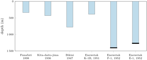
In 1952, on two islands of Enewetak Atoll in the western Pacific (then spelled Eniwetok), two drill holes went down through coral rock to more than . On Parry Island, the bit brought up cuttings of fresh basalt at a depth of 4,158 feet, , and then a core of olivine basalt. Above it lay limestone of Eocene age, full of reef corals of a kind that does not grow deeper than about . A coral reef had once grown on the shoulders of a volcano near sea level, and the volcano had sunk by more than a kilometre while the reef kept growing on top of it. This chapter follows an oceanic island through its whole life: how it grows, how its flanks fall into the sea, why it sinks, and how a ring of coral can outlive it.
You already know
From the Year 1 volume: hotspot, mantle plume, hotspot track and its age progression, the Hawaiian–Emperor chain and the Hawaiian swell; the depth–age law of the ocean floor; reefs, their fringing, barrier and atoll forms as Darwin described them, and the rule “keep up or drown”; eustasy and the sea level of the last glacial maximum, about lower than today. From the school volumes: the shield volcano; the wave-cut platform. From Chapter 9: tholeiitic and alkaline series.
17.1 The growth of a volcanic island
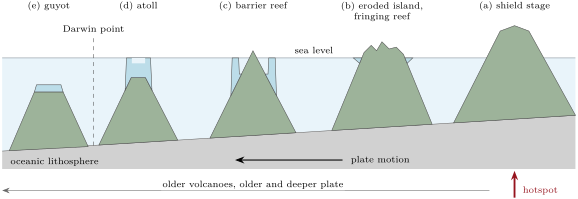
The Hawaiian Islands are the youngest end of the chain that the Year 1 volume followed across the northern Pacific. The main islands hold 19 known shield volcanoes: 15 stand above the sea, 3 are submerged, and one, newly born, is still under water. As the Pacific plate carries them north-west, each is born above the hotspot, grows, dies as it drifts away, and sinks. The life is regular enough to be cut into stages.
Definition 17.1 (Oceanic island; stages of growth)
An oceanic island is a volcanic island that rises from the ocean floor, built on oceanic lithosphere. An island of a hotspot chain passes through four eruptive stages: a preshield stage of small eruptions of alkalic lava on the sea floor; the shield stage, in which tholeiitic lava builds the bulk of the volcano while it lies over the hotspot; a postshield stage of fewer, more alkalic eruptions, which cap the shield; and, after a pause, a rejuvenated stage of rare, small alkalic eruptions. Erosion and sinking then take over.
The stages follow the supply of heat. Loihi, the newest volcano, lies south of the summit of Kilauea; its top is still under the sea but already above the sea floor around it, and its oldest lavas are alkalic. In the shield stage, the volcano lies over the hotspot and is fed at the highest rate. Each Hawaiian volcano erupts an estimated 80 to of its final volume in this stage, mostly within its first 1 to . Late in the stage the rate of eruption drops by a factor of ten. The shallow magma reservoirs, 1 to deep, can no longer be kept alive, though smaller ones at 20 to remain. The lava turns alkalic again, because a lower degree of melting gives it, as Chapter 9 showed. The rejuvenated stage comes after a pause of less than 0.5 to . It can be one or two episodes, or very long: on Niihau it lasted from 2.2 to , and on Kauai it has gone on since .
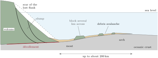
The volumes are enormous. The volume of Mauna Loa is estimated at about . When the boundary with Kilauea is drawn again so that Kilauea keeps only about , Mauna Loa’s share rises to . Young Loihi holds . The whole chain, since , comes to about ; an eruption rate integrated over that history, a year, would give nearly three times as much. The load is heavy enough to bend the plate: the oceanic crust under the islands is pressed down by as much as , along a trough called the Hawaiian Moat, and a low bulge, the Hawaiian Arch, rises a few hundred kilometres away. How a plate bends under a load is taken up in the Year 3 volume. Here the moat matters because it is where much of the debris of the islands ends up.
17.2 Flank collapse
A volcano several kilometres high, built of loose lava flows and rubble, standing on slopes that go down into the moat, is not stable. In 1975 the Kalapana earthquake, of magnitude 7.7, moved the south flank of Kilauea up to towards the sea in one go and raised a tsunami. In 1868, another flank movement came with a magnitude 7.9 earthquake and a tsunami that killed 46 people. Seismic profiles under these flanks show a deep reflector. It is read as a décollement along the top of the old oceanic crust, on which the whole flank slides. Usually the flank creeps; sometimes it fails.
Definition 17.2 (Flank collapse; debris avalanche; slump)
A flank collapse is the failure of a large part of the flank of a volcano, which slides away under its own weight. When the moving mass breaks up and runs out fast, as a flow of blocks and rubble that can travel far beyond the foot of the volcano, it is a debris avalanche. When it moves slowly, as large blocks rotating on faults rooted in a deep décollement and staying near the volcano, it is a slump.
The evidence lies under the sea. In the late 1980s, sidescan sonar mapping of the waters around the Hawaiian Islands showed debris strewn over the deep sea floor, several hundred kilometres from the islands, and slumps made of large segmented blocks. Seventeen large slides were identified around the main islands, formed in the past . Seventy are now known along the Hawaiian Ridge between the Island of Hawaii and Midway, formed over . That is at least one slide every around the main islands. These counts are minima, since a younger volcano can bury the scar and the debris of an older one: the summit caldera and a rift zone of Niihau are missing, and no deposit has been found for them. The giant slides seem most likely while the volcano grows fastest, from the late preshield to the early postshield stage, but they continue long after.
The largest is the Nuuanu landslide, which tore off the north-eastern flank of the Koolau volcano on Oahu. It is a debris avalanche spread over , extending more than from the island. Its blocks include Tuscaloosa Seamount, about long, wide and at least tall. The avalanche crossed the deep moat and climbed more than up the slope of the Hawaiian Arch. Its age is estimated at 2.1 to , near the end of the life of Koolau or after it, whose surface lavas are 1.8 to old. How many collapses it was made of, and how thick it is far from the island, are still open questions.
A slide that falls into the sea pushes the water aside. On Lanai and Molokai, chaotic breccias of coral and lava stand up to above sea level and have been read as the deposits of giant waves raised by collapses. The reading is disputed. Some authors explain the deposits by an uplift of the islands, though drowned reefs south of Lanai show no sign of such an uplift. Roughly a third of the giant Hawaiian slides were debris avalanches able to raise huge waves. How such a hazard is weighed, rare but very large, is a question for Chapter 28.
17.3 Why oceanic islands sink
Two processes make an oceanic island sink, and they overlap. The first is loading: as the volcano grows, its weight pushes the plate down. This rapid phase lasts perhaps a million years and drowns shorelines and reefs by more than a kilometre. Off the north-west coast of the Island of Hawaii, dated drowned reefs give a sinking rate of per thousand years. A small volcano can drown entirely in this phase: Mahukona, beside the Island of Hawaii, was briefly an island and now has its summit at about under water. The second process is the cooling of the plate, which goes on for a hundred million years, and which this section puts in numbers.
The Year 1 volume measured how the ocean floor deepens with its age (in ). In the form used in this chapter:
and, for plates older than about ,
The two forms agree within about between 20 and , and cross at .
Proposition 17.3 (Thermal sinking of an island)
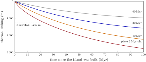
An island built on a plate of age , carried with the plate, loading it with a weight that no longer changes and leaving the cooling of the plate under it unchanged, sinks by
by the time the plate has reached the age , at the rate . With the root law,
and, with the exponential law, . Over a given interval, a young plate carries its islands down further than an old one.
Proof. Compare two columns of the plate, of the same age, one under the island and one under the open ocean far away. Both cool the same way, since the island leaves the cooling of the plate unchanged. So both contract by the same amount, and the top of each goes down by the same amount. The island’s own weight is already balanced and no longer changes, so it adds nothing more. The open-ocean column goes down by ; so does the island. Differentiating gives the rate. For the last claim: over a fixed interval , decreases as grows, since its derivative, , is negative. ∎
The proposition leaves out two things on purpose. The swell of the hotspot lifts the plate as it passes and lets it down again as it moves away, which adds to the sinking of the youngest islands (the Year 1 volume measured the swell). And a load changes while the volcano grows, which is the rapid phase above. Once both are over, the island follows the floor.
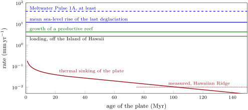
The rates are small. On a plate old, the root law gives per million years, less than a tenth of a millimetre a year. On a plate old, the exponential law gives per million years, or per thousand years. That is the rate measured along much of the Hawaiian Ridge and the Emperor Seamounts. The loading phase, at per thousand years, is some 250 times faster.
17.4 Reefs, atolls and guyots
The Year 1 volume described the three forms of reef as Darwin explained them, from a reef fringing an island to a ring of coral around a lagoon, and ended on a question: why do the islands sink, and how far? The previous section answered it. The forms can now be defined by the state of the island underneath.
Definition 17.4 (Fringing reef; barrier reef; atoll)
A fringing reef is a reef attached to the shore of an island, with no lagoon, or only a narrow, shallow channel, between them. A barrier reef is a reef separated from the shore by a lagoon, on the flanks of an island that has sunk while the reef grew upward. An atoll is a ring of reef, with low islands of reef debris, around a lagoon with no volcanic rock above sea level: its volcano lies entirely under the reef.
Definition 17.5 (Seamount; guyot)
A seamount is a volcano on the ocean floor whose summit lies below sea level, either because it never reached the surface or because it has sunk. A guyot is a seamount with a flat top, cut by waves or capped by a reef when it stood at sea level, and then drowned.
If a reef keeps its top at sea level while the volcano sinks under it, the reef rock piles up as fast as the island goes down. The thickness of the cap then records the sinking.
Proposition 17.6 (Thickness of a reef cap)
Let the last volcanic rock of an island go below sea level when its plate is old, and let a reef keep its top at sea level from then on, until the plate is old. If sea level has risen by between the two times (relative to the centre of the Earth), then the reef cap over the volcano is
thick, the second form with the root law. It does not depend on the rate at which the reef can grow, provided that rate is never smaller than the relative rise of sea level.
Proof. At the top of the volcano is at sea level; at it lies lower by Proposition 17.3, while the sea surface has risen by . The top of the reef is at the sea surface at both times, and its base is the top of the volcano. So the thickness is the distance between them, . A reef that keeps up stops at the surface, so a faster reef does not build a thicker cap; a reef that cannot keep up falls behind and drowns, which is the rule recalled from the Year 1 volume. ∎
Enewetak bears this out. On the root law, a cap of needs : for example, a volcano bevelled to sea level on a plate old and carried until the plate is old. That is , the order of time that separates the Eocene base of the limestone from today. The drill holes also showed what the proposition leaves out. Leached zones, where the aragonite of the corals has been dissolved or recrystallised, record times when the top of the atoll stood above the sea and rain fell on it. Sea level falls and rises with the ice ages, and the cap has been exposed and drowned again many times on its way down.
History — Drilling through atolls, 1896–1952
Darwin’s theory made a prediction that could be checked only with a drill: under an atoll there should be a thick pile of shallow-water reef rock, resting on volcanic rock. The first deep hole on a Pacific atoll was drilled at Funafuti from 1896 to 1898 and stopped at 1,114 feet, , without reaching the volcano. A hole on Kita-daito-jima, south of Japan and east of Okinawa, reached 1,416 feet in 1936, and one on Bikini 2,556 feet in 1947, neither of them reaching it. The holes on Enewetak, in 1951 and 1952, were the first to reach the foundation of an atoll. On Elugelab, hard basement was struck at 4,610 feet; on Parry Island, basalt at 4,158 feet, 450 feet higher, miles away. The drillers had found a basaltic volcano that rises two miles above the ocean floor, capped by reef limestone since the Eocene. Elugelab was destroyed in a test of a thermonuclear device shortly after the drilling ended.
In the field — Drilling an atoll
On Enewetak the geologists set the deep holes close to the lagoon shore, where they expected fewer caverns than near the seaward edge of the reef. Most of the hole was drilled straight, the rock ground to cuttings that the drilling fluid brought up. The cuttings came up late, so the team estimated this lag in order to know from what depth each sample came. At chosen depths a core barrel took a solid cylinder of rock. When the drilling was done, the holes were used as instruments. In one, cased solid down to , the water level still rose and fell with the ocean tide, in step and by the same amount: the limestone of the cap is porous and full of caverns throughout. Others measured the temperature in the holes as it returned to equilibrium.
A reef is not bound to drown because its island sinks. Corals and coralline algae build up millimetres a year: in one modern study, reefs dominated by branching corals grew a year. The cooling plate takes away at most a tenth of a millimetre a year. Thermal sinking alone will never outrun a healthy reef. Reefs drown when something else changes: the plate carries them into water too cool for fast growth; sea level rises faster than they can follow; or both happen at once.
Definition 17.7 (Darwin point)
The Darwin point of a hotspot chain is the place, and the time after the birth of the volcanoes, at which the upward growth of reefs, which slows down in cooler water, no longer makes up for the sinking of the islands. Atolls carried beyond it drown and become guyots.
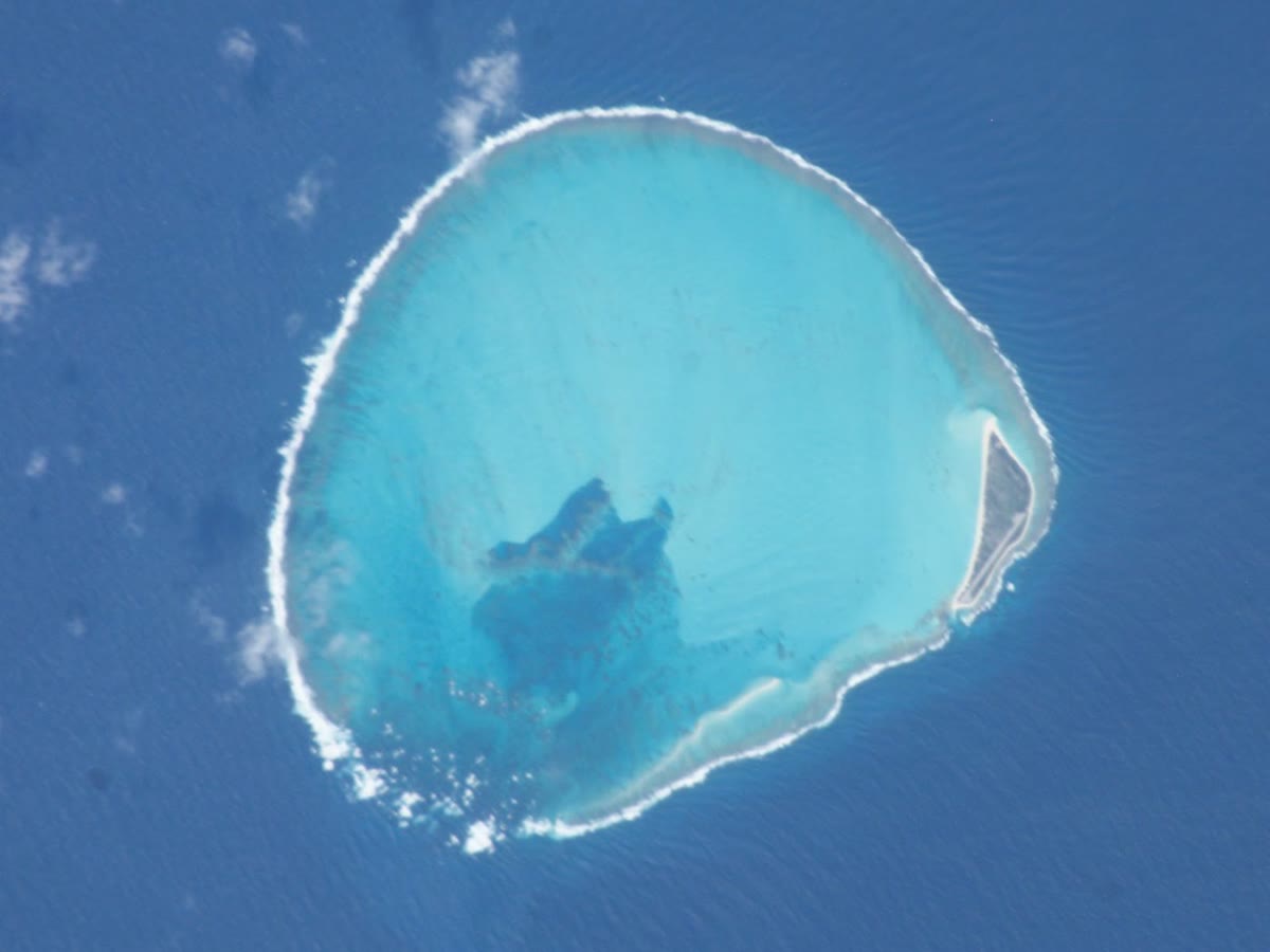
In the Hawaiian chain, the reefs drown about after their volcano was born. Kure Atoll, at the north-western end of the islands, is the northernmost coral atoll in the world, and stands at the Darwin point. Its reef is still growing slightly faster than the atoll sinks. Every volcano beyond Midway and Kure is submerged, and most are guyots. On Koko Seamount, in the southern Emperor chain, carbonate was laid down from about 50 to . Then the last deep-water coralline algae sank below their growth limit, about under the sea. Cooler water alone does not drown the reefs, nor does the sinking alone. The drowning needs the sinking, the drift north into cooler water and rapid changes of climate together.
17.5 Erosion, sea level and the end of an island
While it sinks, an island is also worn down. A high island catches the trade winds: on the windward slopes of the Hawaiian volcanoes, more than of rain falls in a year in places. Streams cut deep canyons in less than a million years, as on Kohala, on the Island of Hawaii. Some great cliffs once taken as the work of erosion alone, such as the sea cliffs of northern Molokai, are now read as the headwalls of giant slides, cut back since. Waves attack the coast and plane a wave-cut platform at sea level around it. Erosion and sinking together remove every trace of volcanic rock above the sea in about . Gardner Pinnacles, of about that age, is the oldest island of the chain where volcanic rock still stands above the water. Beyond it to the north-west there are only sand islands, atolls and drowned volcanoes.
Sea level does not stand still while this goes on. During the last glacial maximum it was about lower than today. The coast of an island then lay lower on its flanks, and the reefs that now fringe it were dry land. When the ice melted, the sea rose by an average of every thousand years over the main deglaciation, from 16.5 to . During Meltwater Pulse 1A it rose by at least a year. A reef on a sinking volcano must follow both rises. Off the north-west coast of the Island of Hawaii, at least six drowned reefs form a staircase on the flank, the oldest the deepest. Each grew at the shore, fell behind during a rise of the sea, and was carried down by the loading of the young island. Once a volcano has sunk more than about , the range of glacial sea level, it will not come back up into the waves.
The arch can work the other way. Oahu sits on the bulge raised by the load of the younger islands, and has risen a little: reefs of the last interglacial, 133 to old, crop out all round the island, and a reef about old now stands above sea level. The end of an oceanic island is thus written in its rocks and its reefs. Lava builds it, slides and rain cut it down, waves plane it, the plate carries it down, and a reef keeps its place at the surface until cold water and a rising sea drown that too.
Exercises
Data for the exercises, unless stated otherwise: depth–age law with for , and beyond ; , , ; reef growth up to .
Exercise 17.1 ★
Name the stage of each volcano: (a) a seamount whose summit is under the sea, erupting alkalic lava; (b) a volcano over the hotspot, erupting tholeiitic lava at a high rate; (c) an extinct volcano whose last flows, more alkalic than the bulk of the island, cap the shield; (d) an island where, after a silence of , a few small alkalic vents open; (e) a ring of reef around a lagoon with no volcanic rock in sight.
Solution
Solution of Exercise 17.1.
(a) Preshield stage, like Loihi today. (b) Shield stage. (c) Postshield stage. (d) Rejuvenated stage. (e) No eruptive stage any more: the volcano has sunk under its reef, which is now an atoll.
Exercise 17.2 ★
A volcano is built on a plate old. (a) How deep is the sea floor around it? (b) How far will it have sunk when the plate is old? (c) At what rate is it sinking then?
Solution
Solution of Exercise 17.2.
(a) . (b) . (c) per million years.
Exercise 17.3 ★
Seventeen large slides formed in the last around the main Hawaiian Islands, and seventy along the Hawaiian Ridge in . (a) Find the mean interval between two slides in each case. (b) Why are both only upper limits of the true interval?
Solution
Solution of Exercise 17.3.
(a) around the main islands; along the ridge. (b) Slides are missed: a younger volcano can bury the scar and the debris of an older one, and old deposits are covered by sediment. The true number is larger and the true interval shorter.
Exercise 17.4 ★
On Enewetak, basalt was met at 4,158 feet in one hole and hard basement at 4,610 feet in the other; the reef corals at the base of the limestone do not live deeper than 150 feet. (a) Convert the three depths to metres. (b) By at least how much has the top of the volcano under Parry Island sunk since the first reef grew on it? (c) The base of the limestone is Eocene, so at least old. What is the largest possible mean rate of sinking?
Solution
Solution of Exercise 17.4.
(a) ; ; . (b) The first reef grew no deeper than and its base is now at : the volcano has sunk by at least (more if sea level was higher then). (c) The sinking is at most about , over at least : at most per million years, a year.
Exercise 17.5 ★★
(a) Find the rate of thermal sinking, in per and in , of islands on plates 4, 25 and old. (b) How many times faster than the fastest of these can a productive reef grow? (c) And how many times faster is the loading phase off the Island of Hawaii, per thousand years?
Solution
Solution of Exercise 17.5.
(a) : () at , () at , () at . (b) times. (c) times: the loading phase sinks an island much faster than the cooling of a young plate.
Exercise 17.6 ★★
(a) With the exponential law, find the rate of sinking on a plate old, in per thousand years, and compare it with the per thousand years measured along the Hawaiian Ridge. (b) On what plate age is the rate exactly ? (c) Check that the two laws give nearly the same depth for a plate old.
Solution
Solution of Exercise 17.6.
(a) per million years, per thousand years: the measured per thousand years. (b) , . (c) Root law: ; exponential law: ; they differ by .
Exercise 17.7 ★★
The Hawaiian reefs drown about after their volcano was born, and volcanism moves along the chain at . (a) How far from the hotspot does an island lie when its reef drowns? (b) Midway is an atoll old: is it consistent that it still has a living reef? (c) Kure lies 55 miles beyond Midway. Estimate its age, and say whether it is close to the Darwin point.
Solution
Solution of Exercise 17.7.
(a) ; . (b) Yes: is less than the after which the reefs drown, so its reef should still be alive. (c) , or more: about . That is somewhat less than , but the is itself an approximate figure for the whole chain, and growth also depends on the water temperature at each atoll: Kure, the last living atoll, is indeed close to the Darwin point.
Exercise 17.8 ★★
In the Nuuanu debris avalanche, Tuscaloosa Seamount is a block about long, wide and at least tall. (a) What volume would a box of these dimensions hold? And a pyramid on the same base and with the same height? (b) Compare with the volume of Kilauea, . (c) The avalanche covers . If it were on average thick (an assumption: its thickness far from Oahu is poorly known), what would its volume be?
Solution
Solution of Exercise 17.8.
(a) Box: ; pyramid: a third, . (b) One block alone is a tenth (box) or a thirtieth (pyramid) of the whole volcano of Kilauea. (c) , a quarter of Kilauea; an estimate that stands or falls with the assumed thickness.
Exercise 17.9 ★★
Off the Island of Hawaii the flank sinks by per thousand years under the load of the volcano. (a) How long does it take to drown a shoreline by ? (b) A reef growing at sits on this flank. Does it keep up when sea level is steady? (c) During the main deglaciation, from 16.5 to , the sea rose by on average. How deep is the top of the reef at the end, if it started at the surface? (d) The same, for a reef on an old volcano that no longer sinks.
Solution
Solution of Exercise 17.9.
(a) . (b) Yes: per thousand years is , less than , a margin of . (c) Relative rise ; the reef falls behind by for : its top ends at . (d) . In both cases it stays above the deepest growth limit but in much dimmer water: whether it catches up depends on how its growth slows with depth.
Exercise 17.10 ★★★
(a) Show that, over a fixed interval , the root law makes an island sink less the older its plate. (b) Compute the sinking over for an island born at the ridge and for one born on a plate old. (c) The plate under a ridge is very hot, and the root law gives an infinite rate at . Is that a problem for the sinking over a finite interval? Explain.
Solution
Solution of Exercise 17.10.
(a) has the derivative : it decreases with . (b) ; . (c) No: is finite at , so the sinking over any interval is finite, in (b). Only the rate at the instant is infinite, where the law is no longer meant to describe the floor in detail.
Exercise 17.11 ★★★
An atoll sinks at , and sea level swings by about with the ice ages, in cycles of about . (a) How far does the atoll sink during one cycle? (b) At a glacial lowstand, how high does the top of the atoll stand above the sea? What happens to the reef rock then? (c) How many cycles does it take for the atoll to sink by the full ? (d) Explain the leached zones found in the Enewetak holes, and why Proposition 17.6 still gives the thickness of the cap over the long run.
Solution
Solution of Exercise 17.11.
(a) . (b) About if its top stood at sea level at the highstand: the atoll becomes a limestone island, rain dissolves the aragonite of the corals and the rock recrystallises to calcite, with caves. (c) cycles, . (d) The leached zones are these times of exposure, sealed under the reef that grew again when the sea came back. Over many cycles the sea returns to similar highstands, so is small, the reef top regrows to sea level at each highstand, and the thickness of the cap is set by the sinking, as the proposition says.
Exercise 17.12 ★★★
An atoll drowns when its plate is old: its reef falls behind and its top ends at the growth limit of the deepest coralline algae, under the sea. (a) With the exponential law, how much further does it sink before the plate is old? (b) How deep is the top of the guyot then? (c) A guyot beside Enewetak has its top at 700 fathoms. Convert, and compare. (d) Name two reasons why a real guyot could be deeper or shallower than this estimate.
Solution
Solution of Exercise 17.12.
(a) . (b) . (c) , deeper than the estimate. (d) The guyot may have drowned earlier, on a younger plate, and sunk more; a neighbouring volcano may have loaded it; its top may have been cut lower by waves, or be covered by sediment; the plate under it may be of a different age; and the sea level of the time of drowning was not today’s.
Problem 17.1
Weekend problem — From volcano to atoll
The invented Petrel Island is born over a hotspot on a plate old. Its volcano is a cone of basal radius . When its growth ends, its summit stands above sea level. Its last volcanic rock disappears below sea level later. A reef then keeps its top at sea level until the plate is old, when the atoll crosses the Darwin point. Use the depth–age law of the exercises (the root law up to , the exponential law beyond), a reef growth of , and the data of the chapter. Sea level is taken as constant, except in questions 8 to 10. Round depths to the metre.
Part I — Growth.
- How deep is the sea floor where Petrel is born?
- What is the height of the volcano above that floor when its growth ends, ignoring the sinking of the floor under the load?
- Find the volume of the cone.
- If of it erupted during a shield stage of , what was the mean rate of eruption? Compare with the supply of Kilauea today, about a year.
- How many Petrels would make one Mauna Loa, at ?
- Which lavas, tholeiitic or alkalic, make up most of the cone? Which cap it?
Part II — Loading and drowned reefs.
- During its growth, the load sinks the young island by in . What is the mean rate, and how does it compare with the per thousand years measured off the Island of Hawaii?
- A reef grows on the shore during this phase, with sea level steady. Does it keep up, and with what margin?
- Sea level then rises by . By how much does the reef fall behind each year?
- How long before its top reaches , the deepest growth limit? What does that leave on the flank of the island?
Part III — Sinking and erosion.
- By how much has Petrel sunk by the time its last volcanic rock disappears, the plate being then old?
- How much of the of the summit did erosion remove, and at what mean rate?
- At what rate is Petrel sinking when its growth ends, and when its summit disappears?
- How deep is the sea floor around it then?
- Compare the it took with the of the Hawaiian Islands. Give a reason why a high Hawaiian island lasts longer.
- Name two processes, besides rain and rivers, that remove the island above sea level.
- Which form of reef surrounds Petrel shortly before its summit disappears?
Part IV — Atoll and guyot.
- How thick is the reef cap when the plate is old?
- What mean rate of reef growth did that need? How many times smaller is it than the growth the reef could reach?
- Compare the cap with the depth of the basalt under Enewetak.
- How deep is the sea floor around the atoll when it crosses the Darwin point?
- With the exponential law, how much further does the drowned atoll sink before the plate is old?
- If the top of the reef stopped at when it drowned, how deep is the top of the guyot then?
- To sum up: how thick is the reef cap of Petrel atoll?
Solution
Solution of Problem 17.1.
1. . 2. . 3. . 4. in : a year, ten times less than Kilauea today. 5. : about eight. 6. Tholeiitic lava, from the shield stage; the alkalic lavas of the postshield stage cap it. 7. per thousand years, 2.6 times slower than off the Island of Hawaii. 8. Yes: to spare. 9. a year. 10. . A drowned reef terrace on the flank, a step of the kind found off the Island of Hawaii. 11. . 12. , at per million years. 13. at first; at the end. 14. . 15. The large Hawaiian islands rise up to about four times higher, so there is far more rock above sea level to remove; their shield stage also lasted longer. 16. Waves, which cut back the coast and plane a wave-cut platform; landslides and flank collapses. 17. A barrier reef, with a lagoon between the reef and the last of the volcanic shore. 18. . 19. per million years, a year: times less than the reef could grow. 20. thicker than the limestone over the basalt under Parry Island (), and thinner than under Elugelab (): the same size. 21. . 22. . 23. . 24. The reef cap of Petrel atoll is thick, about of reef limestone, as under Enewetak.